Fortified Cities from Kortrijk

This route was brought to you by:
RouteXpert Jan Koelstra (jan cabrio)
Last edit: 19-04-2025
 Route Summary
 In addition to admiring these fortifications, attention is also paid to the fortified towns and villages themselves as well as the general sights. The most important military fortifications of both world wars are also mentioned along the route.
The route is rated five stars because of the alternation between the vastness of the landscape, the pleasant, sometimes surprising roads on the one hand and the ingenious constructions of the fortified towns and forts on the other.
 Share this route


Animation

Verdict


Duration
8h 5m

Mode of travel
Car or motorcycle

Distance
190.17 km

Countries


 RouteXpert Review
 The claims of Louis XIV of France on Flanders resulted in five French occupations between 1646 and 1706 and the construction of fortifications as well as the construction of the citadel of Kortrijk. During the wars of Louis XIV of France it became clear that the Spanish Empire was no longer able to defend the Southern Netherlands. If the Southern Netherlands were lost, France would become a threat to the Republic and to the balance of power in Europe. On 11 January 1698, four months after the Peace of Rijswijk, Spain agreed to allow foreign garrisons in the Southern Netherlands. William III of Orange, as stadtholder of Holland and king of England, was allowed to permanently assist in the defence of eight cities: Nieuwpoort, Kortrijk, Oudenaarde, Ath/Aat, Mons/Bergen, Charleroi, Namur/Namen and Luxembourg.
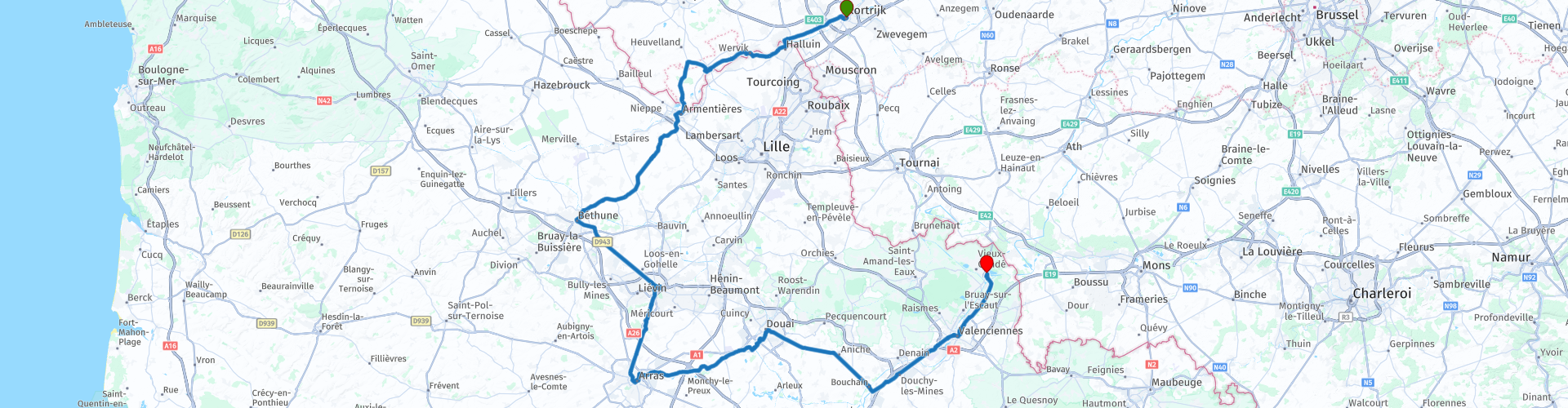
This route runs along the Belgian-French border, starting in Kortrijk in Belgium and ending in the fortified town of Condé-sur-l'Escaut in France.
In the late 17th century and the first half of the 18th century, Kortrijk was one of the fortified towns that formed part of the Dutch fortress barrier in the Southern Netherlands. France even agreed to a permanent Dutch presence in seven places near its border: Veurne, Fort Knokke, Ypres, Warneton/Waasten, Menen, Tournai/Doornik and Namur/Namen.
At your starting point in Kortrijk you will find many historical buildings with a military past, but mostly adapted to the present. The historical civilian buildings will also attract your attention. Well-known attractions of Kortrijk are the Beguinage, the Broel Towers and the shopping centre 'K in Kortrijk'. The Grote Markt of Kortrijk is the centre of the city. When you are on the Grote Markt, you will immediately notice the cosy atmosphere of the many terraces. Here you will find, among other things, the Belfry of Kortrijk, the statues of the Counts of Flanders and also the town hall in late Gothic Renaissance style. To see everything you can spend a week here, but you are not going to do that now. After possibly refuelling, take the road to Menen, once an important fortified town along the border with France.
As a border town, Menen was fortified early on. The first ramparts date from 1578, and Menen was already captured during their construction. Between 1579 and 1830, Menen was besieged twenty-two times. The sieges weighed heavily on the prosperity of the city, the population had left en masse for Haarlem since 1578, and the weaving industry would even halve in the next ten years. Vauban made Menen a model fortification (1679-1689). The fortifications had a circumference of three kilometres with eleven bastions and four city gates. In the following periods of conflict, control over Menen changed continuously between the Southern Netherlands and France until 1815. After the Battle of Waterloo, it became part of the Kingdom of the Netherlands. Menen once again became a fortified city directed against France. In 1830, Menen became part of the new state of Belgium, but the fortifications continued until 1840. From 1852, the fortifications were partially demolished and the military grounds sold. Fortunately, Menen still has many sights, such as the classicist town hall, the 33-metre-high belfry, the St. Vedastus Church and the St. Francis Church. Part of the city wall and casemates can also still be seen. The stone windmill De Goede Hoop, from the second half of the 17th century, was originally an oil mill, later a grain mill.
For Wervik, a few kilometres further on, the First World War also meant four years of German occupation. During the war years, the city was 'borderless', because Wervik and its French sister city Wervicq-Sud formed a single entity for the first time since 1713 (Peace of Utrecht). The quartering of German troops in particular, a stone's throw from the front, gave rise to unusual activities in the border town: a coming and going of German units, transport of wounded and prisoners of war, funeral processions and collective burials. But it was not all doom and gloom, because for the troops present the city also meant a place to catch their breath. The proximity of the battlefield ensured busy industrial and logistical activities to provide the armed forces at the front with the necessary material. The 'Pioniere' (German engineers) played an important role in this. Due to heavy obligations, prohibitions and requisitions, the inhabitants had a hard time. The city was almost completely evacuated in 1917 due to the impending British offensive.
Comines (France) and Comines/Komen (Belgium) are also twin cities and, like Menen and Kortrijk, have been occupied alternately by the neighbouring countries. Nevertheless, Comines has been able to focus on the production of woven carpets and curtains all this time.
In the Middle Ages, the city's centre of gravity was south of the Leie, which meant that the connecting bridge on the north side had to be protected by building fortifications there. The bridge was repeatedly attacked in the course of history. In the Middle Ages, the cloth industry flourished here and from the 18th century, ribbons were produced. However, the castle of Comines was destroyed by the troops of Louis XIV of France.
When the language border was established in 1963, Warneton/Waasten was classified as French-speaking with language facilities for the Dutch-speaking minority. As a result, the still independent municipality of the province of West Flanders was transferred to Hainaut. In 1977, Waasten was incorporated into the merged municipality of Comines-Warneton.
Mesen, the smallest city in Belgium, was at the height of its power in the 11th-12th century. Built around a monastery, which was later elevated to an abbey, it was, with its annual fair, a hub in the cloth industry. This city also regularly fell prey to sieges and destruction in the turbulent 16th century. Mesen barely survived the First World War; as a result, little remains of this historic city. The St. Nicholas Church has a striking domed tower. This is visible from far outside the centre and because of its shape people call it the "dikkop" of Mesen. This church was initially the abbey church of a monastery. After the total destruction in the First World War, it was not rebuilt until 1928. The abbey no longer exists. Under the choir of the church is a Romanesque crypt from the 11th century. There are many reminders of the First World War, such as several cemeteries. Adolf Hitler was said to have been wounded in the forehead by a bullet graze at Messines during the Battle of Ypres. That is why he wore his hair with a blaze to hide the scar on his forehead.
The first town across the current border to France is called Armentières. The same story here too: for centuries the town was on the border between the Dutch-speaking and French-speaking parts of the then county. In June 1518 the town burned down completely in four hours. Of the 1300 houses only three were spared. The town was finally incorporated into France in 1668. In the 19th century it became an industrial town with an important textile industry. The town suffered greatly during both world wars. During the First World War the town was conquered twice by the Germans. Nevertheless there are some sights, such as the Belfry and a number of churches.
After leaving the city, you drive a little further into the interior of France. In the landscape you will find many remains of the coal industry, such as cinder mountains, mine shafts and factory complexes.
As soon as you enter the Grand Place in Béthune, you immediately notice that Béthune must have once been a very important city. The city's history goes back about 1500 years. It all started with a castle, a church and a few houses around it. But soon it became a fortified city with large fortifications that were eventually improved by the famous architect Vauban. In the 13th and 14th centuries, the wealth came from the cloth trade.
Béthune is located at the top of the mining area, which made the region and the city very rich. Trade flourished until the First World War. Béthune was located a few kilometres from the trenches. The city was spared from major destruction for a long time, but in May 1918 it was destroyed for 90%. Fortunately, the residents did not give up and rebuilt their city between 1920 and 1930, in a contemporary style with a sense of tradition.
You may not know it, but besides the Louvre in Paris, there is a second Louvre in Lens. Because the museum in Paris was gradually becoming too small, the French government decided to place a second one here. They did not choose the city of Lens for nothing. Due to the closure of the mines, Lens could use an 'economic boost'. They saw here the opportunity to attract tourists to the old mining city again with the Louvre. The museum is built on a former coal mine and has no less than four departments of permanent collections and a few temporary ones. Although you should not take that 'permanent' too literally because the exhibitions are adjusted on a regular basis.
The city was hit extremely hard in the First World War. The Germans took it in 1914 after heavy fighting. There were also unexploded shells everywhere, which made it difficult to repair the damage. After the liberation in 1918, Lens looked like a moonscape. In addition, there was famine, bad weather and then an outbreak of Spanish flu. More than half of all inhabitants of Lens did not survive the years 1914-1919. Because of this devastation, Lens has almost no monumental buildings from before 1900. Only the 18th century church of Saint-Légèr, in the middle of the city, was carefully rebuilt in the old style.
The nightmare of the First World War has wreaked havoc on the city of Arras, which was already a religious centre in medieval times with the Saint-Vaast Abbey. A restoration has resulted in Arras once again being the magnificent square city of yesteryear. It was not until 1659 that the French crown was finally able to say that Arras was 'French and therefore free'. To defend this freedom, Vauban was sent to Arras. He designed an immense defence system. In this Citadelle Vauban you will find a chapel in baroque style. Arras is especially loved for its beautiful baroque squares, such as 'la Grand Place' and 'la Place des Héros', which are located in the beating heart. With its many houses in Flemish baroque style, the city can be called picturesque. You will automatically come across the Notre Dame Cathedral with its beautiful classical architecture. The interior of the cathedral is also a feast for the eyes. Further on is the Saint-Vaast Abbey, which now houses the Museum of Fine Arts.
The ornate Gothic bell tower of Douai was built in 1380 on the site of an earlier tower. The 80-metre-high belfry tower houses an impressive carillon with 62 bells with a range of 5 octaves. The belfry is part of the town hall complex. The massive city gate 'Porte de Valenciennes', a reminder of the military importance of the city in the past, was built in 1453. One side is built in Gothic style, while the other has a classicist design. Douai Abbey is a Roman Catholic monastery of monks of the English Benedictine Congregation, founded in Paris in 1615.
Next to the town hall with the Gothic style belfry and the gate of
Valenciennes, the collegiate church of Saint-Pierre, the church of Notre-Dame, the Dauphin's mansion overlooking the Place des Armées and the facade of the Palais de Justice can be admired. The Chartreuse Museum houses numerous works, including the relief plan by Vauban.
A little further east lies Bouchain, which was taken by Spanish troops in 1580. The governor of Bouchain negotiated a free retreat. However, he left behind burning fuses, which caused major explosions after his departure. After the function of the rampart no longer functioned, the ramparts of Bouchain were dismantled in several phases, between 1837 and 1893. The city suffered serious damage during the First World War. Of the described defences, only the Ostrevant tower from 1164 modified by Vauban, the gunpowder house from 1687, the bastion des Forges with part of the ring wall from the 16th century, tunnel galleries, two halls under the Timothée Trimmplein, a 19th-century site and the old moats of the fortifications in the lower city remain.
Since 1071, Valenciennes has been the capital of the county of Hainaut. As a result, it later became part of the Burgundian states and then also of the Habsburg Netherlands. Around 1560, Valenciennes was a hotbed of Calvinism. In 1562, the first violent resistance in the Netherlands against religious persecution broke out here: a few Protestants condemned to the stake were freed by a mob. After yet another siege in 1677, Valenciennes and large parts of Hainaut were occupied by the French and with the Peace of Nijmegen in 1678, the region became part of France. Valenciennes grew thanks to its mining and steel industry, and it takes some time to get under your skin. The Rue du Béguinag is interesting, which makes you long for the 1950s. Be sure to pass the atmospheric Place du Neuf Bourg, with cafés on one side and Parisian mansions on the other. And the Rue des Sayneurs, perhaps one of the most beautiful streets in the city. Perfectly renovated and restored to its former glory.
Surrounded by forests and situated on the Scheldt river, Condé-sur-l'Escaut still retains part of its fortifications. Its strategic location would make Condé one of the military centres of Northern France. Burgundian, Austrian and Spanish rulers left their mark there. What remains of the stronghold: a castle and a medieval wall, a gate, bastions (by Vauban), the Hôtel de Bailleul, a 15th century fortified building with corner turrets, and the cavalry quarter to the south, where two squadrons (almost 400 men and 300 horses) were stationed in the barracks.
After all the display of power, it is time to end this ride in a completely different style, by looking for a place where perhaps some of the local delights can be sampled.


 Links
Links  Usage
Usage Want to download this route?
You can download the route for free without MyRoute-app account. To do so, open the route and click 'save as'. Want to edit this route?
No problem, start by opening the route. Follow the tutorial and create your personal MyRoute-app account. After registration, your trial starts automatically.  Disclaimer
Use of this GPS route is at your own expense and risk. The route has been carefully composed and checked by a MyRoute-app accredited RouteXpert for use on TomTom, Garmin and MyRoute-app Navigation.
Changes may nevertheless have occurred due to changed circumstances, road diversions or seasonal closures. We therefore recommend checking each route before use.
Preferably use the route track in your navigation system. More information about the use of MyRoute-app can be found on the website under 'Community' or 'Academy'.

Hauts de France
About this region
Hauts-de-France (French pronunciation: [o də fʁɑ̃s] (listen); Picard: Heuts-d'Franche; lit. 'Heights of France') is the northernmost region of France, created by the territorial reform of French regions in 2014, from a merger of Nord-Pas-de-Calais and Picardy. Its prefecture is Lille. The new region came into existence on 1 January 2016, after regional elections in December 2015. The Conseil d'État approved Hauts-de-France as the name of the region on 28 September 2016, effective the following 30 September.With 6,009,976 inhabitants (as of 1 January 2015) and a population density of 189 inhabitants/km2, it is the third most populous region in France and the second most densely populated in metropolitan France after its southern neighbour Île-de-France. It is bordered by Belgium to the north.
Read more on Wikipedia
View region
 Statistics
  33
33Amount of RX reviews (Hauts de France)
 26533
26533Amount of visitors (Hauts de France)
 2309
2309Amount of downloads (Hauts de France)
 Route Collections in this region
 24 Magnificent trails in France
It is clear that France is one of the most beautiful and best touring countries. It offers an incredibly varied landscape with good roads and a pleasant climate. It is not for nothing that you see so many motorcyclists there. My previous collection of 25 routes in France (25 Magnificent routes in France) were based on the route descriptions from the Motortourgids France part 1 made by Bert Loorbach.
This collection of 24 routes comes from Motortourgids France part 2. In this collection, a difference has been made between approach routes and motorcycle tours in a certain area. The approach routes can also be used in combination with the routes from Motortourgids France part 1
The routes are sometimes slightly adjusted based on the tips that Bert Loorbach gives in his description, or because of another place to spend the night, or to reach the minimum length of 2 hours for the MRA Library. For each route, the review contains a more detailed description, including options to stay overnight or places of interest along the way, which are also indicated with a POI and if possible with a short description.
Two or more routes have been created for a number of areas, such as for Burgundy, Auvergne, The Alps, Tarn and Cévennes and Nord-Pas de Calais. These routes can be nicely combined in a multi-day trip.
View Route Collection
The 10 most downloaded routes in France from RouteXpert Catherine De Groote
Hello and welcome to this collection of the Top 10 MyRoute app downloaded routes in France.
A great new event will be announced soon, where all of these routes can be driven.
Download them all now and place them in a new "Top 10" folder so that you always have them at hand.
If you are going to drive one of these routes in the meantime, track them with the MRA Mobile App or with MRA Navigation. Take some photos (moments) along the way as they will come in handy.
Create a travelogue of your Top 10 driven routes and add the recorded track to it.
There will also be some great prizes on offer, so keep an eye on the MRA-RouteXperts page and your email.
View Route Collection