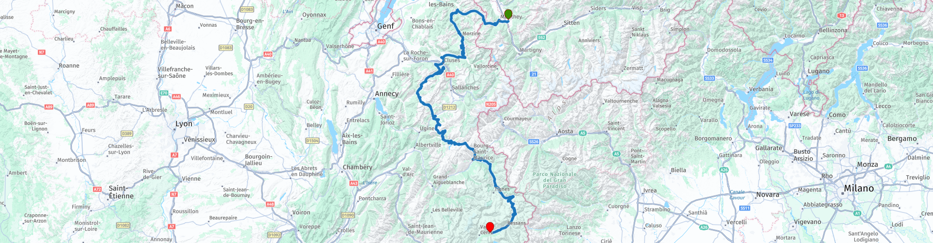
Bex Lanslebourg Rhonedal Mont Cenis

This route was brought to you by:
RouteXpert Hans van de Ven (Mr.MRA)
Last edit: 08-10-2024
 Route Summary
 The ride ends in Lanslebourg, and is available for TomTom, Garmin and MyRoute-app Navigation users. A ride from A to B that you should not miss, but be prepared for challenging mountain roads—average mountain experience is recommended.
If you plan to ride this route, make sure you are well prepared and enjoy the pure beauty of the Alps.
Source: Promotor 07, September/October 2018.
 Share this route


Animation

Verdict


Duration
7h 39m

Mode of travel
Car or motorcycle

Distance
330.52 km

Countries


 RouteXpert Review
 Col du Corbier (1235 m), Col du Ranfolly (1250 m), Col de Joux Plane (1700), Col de la Colombiére (1618 m), Col des Aravis (1498 m), Col des Saisies (1438 m), Cormet de Roselend (1938 m), Col de l'Isera (2270 m).
This 5-star route is one of the 24 most beautiful Alpine routes in recent years!
Colored route points:
rp 9 - Coffee stop at Lhottys
rp 15 - Lunch stop at Restaurant Le Jalouvre
rp 19 - Coffee stop at Le Mont-Blanc
rp 28 - Coffee stop at Restaurant La Bouida
rp -34 - Tank stop at Avia
Route details:
-Winter closing: Col de l'Iseran and Cormet de Roselend from the beginning of October to the end of May. The other passes and roads are closed briefly depending on the weather.
-Alternative routes: South side of the Col du Petit St. Bernard (2188 m).
Ideal months: June to October. Chance of closing the high passes in September.
- Driving pleasure: Constantly, but Cormet de Roselend and the south side of the Col de l'Iseran stand out.
-Landscape: Cormet de Roselend and Col de l´Iseran. The view of Val d'Isère from the north side of l'Iseran is beautiful. At the start of the tour, the Col de Joux Plane offers an impressive view of the north-western flank of the 4810 m high Mont Blanc massif.


 Links
Links  Usage
Usage Want to download this route?
You can download the route for free without MyRoute-app account. To do so, open the route and click 'save as'. Want to edit this route?
No problem, start by opening the route. Follow the tutorial and create your personal MyRoute-app account. After registration, your trial starts automatically.  Disclaimer
Use of this GPS route is at your own expense and risk. The route has been carefully composed and checked by a MyRoute-app accredited RouteXpert for use on TomTom, Garmin and MyRoute-app Navigation.
Changes may nevertheless have occurred due to changed circumstances, road diversions or seasonal closures. We therefore recommend checking each route before use.
Preferably use the route track in your navigation system. More information about the use of MyRoute-app can be found on the website under 'Community' or 'Academy'.
Vaud
About this region
Vaud ( VOH; French: (Canton de) Vaud, pronounced [kɑ̃tɔ̃ də vo]; German: (Kanton) Waadt, pronounced [vat] (listen) or [vaːt]), more formally the canton of Vaud, is one of the 26 cantons forming the Swiss Confederation. It is composed of ten districts and its capital city is Lausanne. Its flag bears the motto "Liberté et patrie" on a white-green background.
Vaud is the third largest canton of the country by population and fourth by size. It is located in Romandy, the French-speaking western part of the country; and borders the canton of Neuchâtel to the north, the cantons of Fribourg and Bern to the east, the canton of Valais to the south, the canton of Geneva to the south-west and France to the west. The geography of the canton includes all three natural regions of Switzerland: the Jura Mountains, the Swiss Plateau and the (Swiss) Alps. It also includes some of the largest lakes of the country: Lake Geneva and Lake Neuchâtel. It is a major tourist destination, renowned for its landscapes and gastronomy.
The largest city is Lausanne, followed by Yverdon-les-Bains and Montreux. As of 2020 the canton has a population of 814,762. It is one of the four cantons where French is the sole official language. Formerly a Bernese bailiwick, Vaud joined the Swiss Confederation as an independent canton in 1803.
Read more on Wikipedia
Vaud is the third largest canton of the country by population and fourth by size. It is located in Romandy, the French-speaking western part of the country; and borders the canton of Neuchâtel to the north, the cantons of Fribourg and Bern to the east, the canton of Valais to the south, the canton of Geneva to the south-west and France to the west. The geography of the canton includes all three natural regions of Switzerland: the Jura Mountains, the Swiss Plateau and the (Swiss) Alps. It also includes some of the largest lakes of the country: Lake Geneva and Lake Neuchâtel. It is a major tourist destination, renowned for its landscapes and gastronomy.
The largest city is Lausanne, followed by Yverdon-les-Bains and Montreux. As of 2020 the canton has a population of 814,762. It is one of the four cantons where French is the sole official language. Formerly a Bernese bailiwick, Vaud joined the Swiss Confederation as an independent canton in 1803.
View region
 Statistics
  14
14Amount of RX reviews (Vaud)
 14733
14733Amount of visitors (Vaud)
 278
278Amount of downloads (Vaud)
 Route Collections in this region
 The 24 Most Beautiful Alpine Routes
The Alps, The Alps are a mountain range in Europe, stretching from the French Mediterranean coast in the southwest to the Pannonian Plain in the east. The area of the mountain range is more than 200,000 km².
In other words Passes and Mountain Roads!
Driving through the mountains is great! Especially over the mountain passes with hairpin bends and narrow winding roads. Every bend a different view where you can enjoy. There are many beautiful mountain passes in the Alps.
A selection that has also been incorporated into these routes:
The Stlevio Pass:
The Stelvio Pass, also known as Passo dello Stelvio, is mainly known for the stage in the Giro d'Italia. Due to the length and the difference in height, this pass is seen as one of the toughest tests in cycling. The Stelvio Pass reaches a maximum height of 2758 meters and is therefore one of the highest in the Alps. The pass connects the towns of Bormio and Prato Allo Stelvio. In winter the pass is closed due to heavy snowfall.
The Reschenpass:
The Reschenpass, also known as Passo di Resia, connects the Austrian state of Tyrol with the Italian province of South Tyrol. The pass reaches a maximum height of 1,504 meters and has been one of the most important north-south connections in the Alps in recent centuries. The pass was used long before Roman times. Along the way you will pass several highlights and historical relics. One of the highlights is the Reschensee. This lake was created after the construction of the dam and has completely submerged the village of Graun. The only thing that reminds of that is the clock tower in the middle of the lake.
Col du Galibier:
The French mountain pass Col du Galibier connects the towns of Saint-Michel-de-Maurienne and Briançon via the Col du Lautaret in the south and the Col du Télégraphe in the north. The mountain pass is part of the Tour de France and very much feared, due to the fact that it can only be reached via the other two mountain passes. The pass reaches a maximum height of 2646 meters. From there you can take a walk to the viewpoint at 2704 meters. You can admire the peaks of the Grand Galibier, Mont Blanc and La Meije here.
The Grossglockner High Alpine Road:
With a height of 3798 meters the Grossglockner is the highest mountain in Austria. To fully enjoy this impressive mountain, you can drive over the Grossglockner High Alpine Road and the accompanying pass. The route starts from Bruck am Grossglockner and ends in Heiligenblut. Of course you can drive in two directions. The pass reaches a maximum height of 2504 meters and is closed in winter due to heavy snowfall. Along the way you pass several stops with fun activities, information points, mountain huts and viewpoints. A visit to the Kaiser-Franz-Josefs-Höhe and Pasterzen Glacier is highly recommended.
The Col d'Izoard:
Just like the Col du Galibier, the Col d'Izoard is also part of a stage of the Tour de France. The mountain pass connects Briançon with the valley of the river Guil. The pass is partly located in the Regional Natural Park du Queyras and reaches a maximum height of 2360 meters. What is special about the Col d'Izoard is the barren and rocky landscape. Sometimes it feels like driving a car over the moon! Along the way you can stop at several points to enjoy the beautiful view.
The Bernina Pass:
The Bernina Express is one of the most famous rail trains in Switzerland and the Alps. The route is beautiful and partly included on the UNESCO World Heritage List. Parallel to the railway lies the Bernina pass, which connects the Veltlin valley with the Egandin valley. This beautiful Alpine road has a total length of 56 kilometers and reaches a maximum height of 2328 meters. Along the way you can enjoy views of the Morteratsch Glacier.
The Sella Pass:
The Sella Pass, also known as Passo di Sella, takes you over one of the most impressive mountain ranges in the Dolomites: the Sella massif. The pass connects Valle di Fassa with Val Gardena and reaches a maximum height of 2236 meters. At this height is also the border of the Italian provinces of Trentino and Bolzano. Along the way you can enjoy the view of this spectacular mountain world. Admire, for example, the three peaks of the Sasso Lungo massif, the Sella massif or the peaks of the Marmolada. You can also drive the Sella pass in combination with the Gardena pass, Pordoi pass and Campolongo pass.
The Grimsel Pass:
The Grimsel Pass connects Goms in Wallis with the Halis Valley in the Bernese Oberland. The pass reaches a maximum elevation of 2165 meters and is closed in winter due to snowfall. Over the centuries, the mountain pass has played an important role in trade between Switzerland and Italy. Now it is mainly the reservoirs that have an important function. These are used to generate electricity. The landscape you drive through is rugged, rocky and impressive. On top of the pass is a hotel and a restaurant with a special marmot park. The Dodensee (Totensee) is also located here. This lake owes its name to the many soldiers who died in the time of Napoleon.
The Gotthard Pass:
The Gotthard Pass, also known as Passo del San Gottardo and Saint Gotthard, connects the Swiss towns of Airolo and Andermatt. The mountain pass and associated tunnel are especially known among holidaymakers driving from Switzerland to Italy. But where the majority opt for the tunnel, it is precisely the pass that really completes the holiday. The Gotthard Pass has a length of about 26 kilometers and reaches a maximum height of 2106 meters. The route is beautiful and takes you along old villages and beautiful views.
The Silvretta High Alpine Road and Silvretta Pass:
The Paznaun Valley in Tyrol and the Montafon in Vorarlberg are connected by the Silvretta High Alpine Road. The route has a length of 22.3 kilometers and leads from Galtür to Partenen in 34 hairpin bends, via the 2032 meter high Bielerhöhe. The Silvrettasee is also located at this point, where you can enjoy a lovely walk. The pass is closed in winter due to snowfall.
The Simplon Pass:
Just like the Gotthard Pass, many holidaymakers also travel over the Simplon Pass every year. This mountain pass connects the Rhone Valley in the canton of Valais with the Valle d'Ossola in Piemonte. The pass is open all year round and reaches a maximum height of 2005 meters. Along the way you pass a number of buildings, including the well-known Simplon Hospiz from 1825. The hospiz is managed by the monks of St. Bernard. From the highest point on the pass, all kinds of hiking routes are possible and you will also come across a hotel where you can spend the night.
The Gerlos Pass:
The Gerlos Pass connects the Salzach Valley in the Salzburgerland with the Zillertal Valley in Tyrol. The pass is part of the Gerlos Alpenstraße and runs right through the Hohe Tauern National Park. Along the way you can enjoy beautiful views of the surroundings. The pass has a length of 12 kilometers and reaches a maximum height of 1531 meters. A ride over the Gerlos Pass can be ideally combined with a visit to the Krimmler Wasserfälle.
The Great St. Bernard Pass:
The Great St. Bernard Pass, better known as Col du Grand Saint Bernard, connects the Italian province of Valle d'Aosta with the Swiss canton of Valais. The pass is one of the highest in Switzerland and reaches a maximum height of 2469 meters. Like a number of other mountain passes in this list, the Great St. Bernard Pass has also been used as a connecting road for centuries. The pass is named after the St. Bernard dogs that used to help stranded travelers along with the monks. The pass is closed in winter.
The Timmelsjoch High Alpine Road:
The Timmelsjoch High Alpine Road connects the towns of Sölden in the Ötztal and Meran in South Tyrol. Tolls must be paid on the Hochgurgl - Moos route. Via a mountain road with about 60 hairpin bends you drive through a beautiful mountain world. With the Timmelsjoch Experience you can learn more about the history, the road and the environment via various stations. You can also visit the Top Mountain Crosspoint museum.
Col de l'Iseran:
With a maximum pass height of 2770 meters, the Col l'Iséran is one of the highest mountain passes in the Alps. The pass connects Bourg-Saint-Maurice with Bonneval-sur-Arc. Via a road full of hairpin bends you pass, among other things, Val-d'Isère and a side valley of the Maurienne that lies entirely in the National Park de la Vanoise. You can spot animals such as marmots and chamois and there is also a restaurant with a chapel on top of the pass.
The Gavia Pass:
The Gavia Pass (Italian Passo di Gavia) is a mountain pass in the Italian Alps, in the Lombardy region.
It is one of the highest pass roads in Europe. The road leads through the unspoilt Stelvio National Park. The road was built in the First World War to supply Italian soldiers who fought in the Italian-Austrian border area. The pass height is one of the most beautiful in the Alps. Here is the large Lago Bianco with, to the north, the mountain San Matteo (3684 meters). Lago Nero is slightly lower on the south side of the pass. Here the mountain group of the Adamello determines the view. There are many well-marked walks in the area. During the winter the pass is closed due to the heavy snowfall. The pass is often closed until May and June due to the large amount of snow.
Promoter has made a selection of the 24 Most Beautiful Alpine routes that they have set out in recent years.
The routes go through:
France
Austria
Switzerland
Italy
The most beautiful roads, the most beautiful views, the most beautiful viewpoints. The highest mountains, the fastest descents, hairpin bend after hairpin bend, you name it you can't get enough of it.
If you go on holiday in this region, take advantage of it, ALL routes in this collection have been checked and made equal for TomTom, Garmin and MyRoute-app Navigation by a MyRoute-app RouteXpert.
Have fun with this collection and while driving one of these routes. Enjoy all the beauty that the Alps and the Dolomites have to offer. Click on “View route” to read the review of the chosen route.
I would like to hear your findings about the route(s).
View Route Collection
From the Eifel via the Alps to the Dordogne in 5 great days
Literally from the start of the Eifel you go to Camping Moto van Hans in 5 crazy rides. You cross 3 countries (Germany, France and Switzerland) several times and the number of motorcycle areas is phenomenal. Eifel, Moselle, Hunsrück, Pfälzerwald, Vosges, Jura, Alps and then along France's most beautiful rivers, the Drome, Tarn, Lot and Dordogne. The number of bends is indescribable. Make sure your phone / camera has enough space, because you will rarely experience so much beauty in such a short time. Note: Driving in mountainous areas requires some experience, the journey as a whole is "spicy"
Day 1 starts in the Eifel and ends in the middle of the Vosges. With MRA it is possible to find the smallest and best roads, which are ideal for this type of route. In the evening of course eating Flammkuchen! However, this route and that of day 2 have to be careful when working on the road in France. Gravel is sprinkled on the road here and that is not always convenient for motorcyclists.
Day 2 goes partly through the Vosges, then the Jura and then you drive a long way through Switzerland. Watch out for your speed here, otherwise it could be very expensive. You don't drive through the highest part of Switzerland, but there is plenty to steer and plenty to see. Your hotel is in Martigny. You can eat in the center, which you reach after 5 minutes.
Day 3 just starts in Switzerland and soon you are on the Route des Grandes Alpes. You tackle a number of very high passes here, such as the Iseran and the Galibier. The height differences are enormous here, you drive here deep valleys and high peaks. Spending the night in Serre Chevalier (where you could theoretically have skied a few months earlier) is a very special experience.
Day 4 still has some big passes in store, after that the route runs via the Drome and the Tarn. The rivers have cut very deep gorges in the relatively soft chalk, resulting in steep mountain formations. A lust for the eye! The old monastery where the hotel is located is not only a feast for the eyes, but also a rich culinary experience.
Day 5 is the last day and takes you through the Cévennes National Park. Simply put, a very large forest, but there is more. The highest peak is 1,900 meters and the roads in the Cévennes are generally very narrow. This has the advantage that they are not used much. Ergo low-traffic and excellent quality. However, on these very narrow roads you have to watch out for the local population and "waste" from the trees. The first don't take it so well with the course of the road and you regularly see it right in front of you on your side of the road, the second occasionally causes broken branches on the road. There is a good chance that at the end you will find Hans with a big grin and a welcome beer waiting for you.
All in all a very impressive ride. All 1,824.75 kilometers (according to MRA) are delightful. The roads are good, the hotels were all excellent, there were certainly culinary delights and the undersigned was very lucky that there were hardly any clouds during all 5 days (August 2023). For the less experienced rider it is advisable to gain some knowledge in advance about riding in mountains and/or to take a rest day after the "queen stage" (day 3).
For those who are going to make the journey: lots of safe kilometers and lots of fun.
View Route Collection