Day 12 TCH Winnipeg to Kenora

This route was brought to you by:
RouteXpert René Plücken (MRA Master)
Last edit: 05-11-2025
 Route Summary
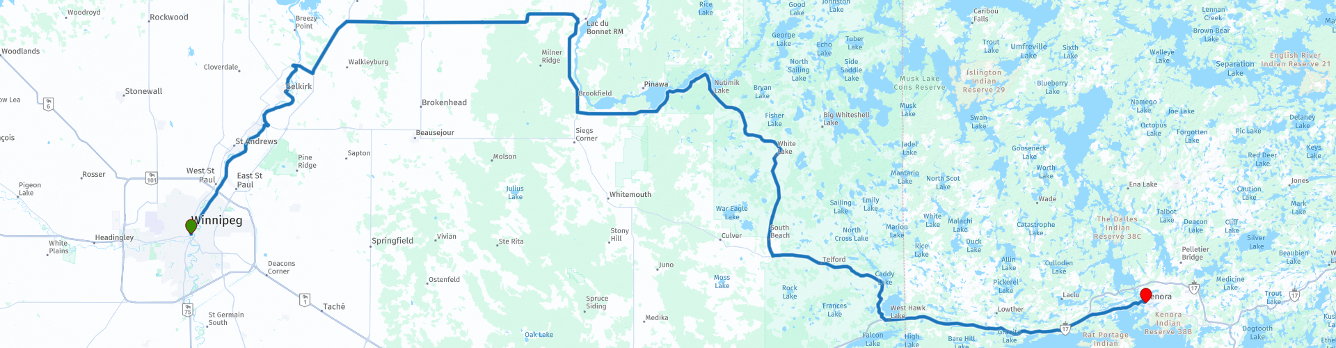
 This is section 12 which runs from Winnipeg to Kenora.
The Trans-Canada Highway passes through all of the country's southern provinces. The route can be driven in various ways, as there are several alternative routes that also belong to the Trans-Canada Highway. The total distance is around 8,000 km. We won't be driving solely the Trans-Canada Highway, but will be taking as much of the country's back roads as possible, as highway driving alone is too boring, and Canada boasts many beautiful roads through its stunning landscape.
You'll drive through all the provinces and through very diverse and picturesque landscapes, from the Rockies in the west, the Central Prairies to the eastern Maritimes and the northern forest.
The riding season is generally from April to October with longer seasons on the west coast and southern Ontario.
Make sure you have good all-season clothing or bring rain gear. Depending on the province and the season, the weather can change suddenly and you might be surprised by a rain shower, or even a snow or hail shower, so be prepared.
In Canada, the metric system is used, so speeds are indicated in km/h. Helmets are mandatory throughout Canada (DOT approved).
Throughout Canada, you'll see plenty of wildlife. Similar animals vary from province to province, including deer, buffalo, moose, caribou, wolves, cougars, bears, mountain goats, sheep, lynx, coyotes, foxes, raccoons, badgers, various rodents, and a variety of birds.
Even though it is very tempting to stop for a photo, don't do it, it can be very dangerous.
This route is 300 kilometers long and worth 3*** stars because of the beautiful nature, hills, lakes and green plains, unfortunately there are not many sights along the way where you can stop for a while.
 Share this route


Animation

Verdict


Duration
7h 38m

Mode of travel
Car or motorcycle

Distance
299.55 km

Countries

 RouteXpert Review
 The morning in Winnipeg is bright and crisp. Today we're driving to Kenora, a 300-kilometer stretch through the heart of Manitoba and a bit of Ontario. The official route via the Trans-Canada Highway is shorter, 223 kilometers, but also boring. We're opting for adventure: provincial roads, winding paths, and the land of 100,000 lakes.
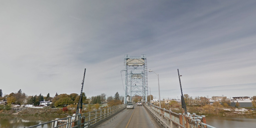
We leave Winnipeg via Main Street and follow Henderson Highway (42) along the Red River of the North. We cross the river via the Selkirk Lift Bridge, a steel bridge built in 1935. The central section can be lifted, an ingenious system of pulleys and counterweights, a nod to a time when engineering was pure art.
Further north, we take Provincial Trunk Highway 59 towards Libau, turn right onto Provincial Road 317 to Lac du Bonnet, and then follow Highway 11 along the glistening Winnipeg River. The landscape slowly changes: forests, rocks, and lakes appear like blue mirrors amidst the greenery. This is where the real Manitoba begins, the land of water and wilderness.
We take a break at Lac du Bonnet. There's a small supermarket, two restaurants, and a gas station—a welcome stop, as amenities are scarce along the way. We stock up on sandwiches and water.
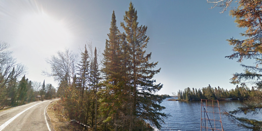
On Provincial Road 307, we drive deeper into the lake district. The asphalt winds along the banks, and with every bend a new panorama opens up. For hikers, there are well-marked and inviting trails along the route.
We stop at Bannock Point Petroforms, mystical stone formations shaped like turtles, snakes, and a Thunderbird. They were laid centuries ago by First Nations as part of ceremonies and lessons. It feels as if the stones whisper of a past that is still very much alive.
At the end of Road 307, we turn left onto Highway 44, continuing until we reach Whiteshell, where we join the Trans-Canada Highway for the final stretch to Kenora. At the Ontario border, there's an opportunity to stop at the Manitoba Visitors Center for a souvenir and to take a photo at the Ontario Welcome Sign.
The Ontario landscape is surprising: rolling hills, dense forests, and even more lakes. The road winds gently, and the sky reflects in the water. Just before Kenora, we stop at Husky the Muskie, a giant replica of a muskie fish, 12 meters long and weighing 2.5 tons. Since 1967, it has stood guard over Lake of the Woods, a symbol of pride and tradition.
As we enter Kenora, the evening sky turns pink over the water. This leg gets three stars: not for spectacular sights, but for the sheer beauty of the lakes, forests, and cliffs. Tomorrow we continue, deeper into Ontario, where adventure awaits.
 Links
Links  Usage
Usage Want to download this route?
You can download the route for free without MyRoute-app account. To do so, open the route and click 'save as'. Want to edit this route?
No problem, start by opening the route. Follow the tutorial and create your personal MyRoute-app account. After registration, your trial starts automatically.  Disclaimer
Use of this GPS route is at your own expense and risk. The route has been carefully composed and checked by a MyRoute-app accredited RouteXpert for use on TomTom, Garmin and MyRoute-app Navigation.
Changes may nevertheless have occurred due to changed circumstances, road diversions or seasonal closures. We therefore recommend checking each route before use.
Preferably use the route track in your navigation system. More information about the use of MyRoute-app can be found on the website under 'Community' or 'Academy'.

Manitoba
About this region
Manitoba ( (listen)) is a province of Canada at the longitudinal centre of the country. It is Canada's fifth-most populous province, with a population of 1,278,365 as of 2016. The easternmost of the three prairie provinces, Manitoba covers 649,950 square kilometres (250,900 sq mi) of widely varied landscape, from arctic tundra and the Hudson Bay coastline in the north to dense boreal forest, large freshwater lakes, and prairie grassland in the central and southern regions.
Indigenous peoples have inhabited what is now Manitoba for thousands of years. In the early 17th century, British and French fur traders began arriving in the area and establishing settlements. The Kingdom of England secured control of the region in 1673 and created a territory named Rupert's Land, which was placed under the administration of the Hudson's Bay Company. Rupert's Land, which included all of present-day Manitoba, grew and evolved from 1673 until 1869 with significant settlements of Indigenous and Métis people in the Red River Colony. In 1869, negotiations with the Government of Canada for the creation of the province of Manitoba commenced. During the negotiations, several factors led to an armed uprising of the Métis people against the Government of Canada, a conflict known as the Red River Rebellion. The resolution of the conflict and further negotiations led to Manitoba becoming the fifth province to join Canadian Confederation, when the Parliament of Canada passed the Manitoba Act on July 15, 1870.
Manitoba's capital and largest city is Winnipeg, the seventh most populous municipality in Canada. Winnipeg is the seat of government, home to the Legislative Assembly of Manitoba and the Provincial Court. Four of the province's five universities, all four of its professional sports teams, and most of its cultural activities (including Festival du Voyageur and Folklorama) are located in Winnipeg. The city has train and bus stations and an international airport; a Canadian Forces base, CFB Winnipeg, operates from the airport and is the regional headquarters of the North American Aerospace Defense Command.
Read more on Wikipedia
Indigenous peoples have inhabited what is now Manitoba for thousands of years. In the early 17th century, British and French fur traders began arriving in the area and establishing settlements. The Kingdom of England secured control of the region in 1673 and created a territory named Rupert's Land, which was placed under the administration of the Hudson's Bay Company. Rupert's Land, which included all of present-day Manitoba, grew and evolved from 1673 until 1869 with significant settlements of Indigenous and Métis people in the Red River Colony. In 1869, negotiations with the Government of Canada for the creation of the province of Manitoba commenced. During the negotiations, several factors led to an armed uprising of the Métis people against the Government of Canada, a conflict known as the Red River Rebellion. The resolution of the conflict and further negotiations led to Manitoba becoming the fifth province to join Canadian Confederation, when the Parliament of Canada passed the Manitoba Act on July 15, 1870.
Manitoba's capital and largest city is Winnipeg, the seventh most populous municipality in Canada. Winnipeg is the seat of government, home to the Legislative Assembly of Manitoba and the Provincial Court. Four of the province's five universities, all four of its professional sports teams, and most of its cultural activities (including Festival du Voyageur and Folklorama) are located in Winnipeg. The city has train and bus stations and an international airport; a Canadian Forces base, CFB Winnipeg, operates from the airport and is the regional headquarters of the North American Aerospace Defense Command.
View region
 Statistics
  3
3Amount of RX reviews (Manitoba)
 9302
9302Amount of visitors (Manitoba)
 125
125Amount of downloads (Manitoba)
 Route Collections in this region
 Trans Canada Highway
The Trans-Canada Highway (TCH) or Trans-Canadian Highway is a system of highways that cover all 10 provinces of Canada.
The Federal and Provincial Highways System that now forms the TCH were authorized by the Trans-Canada Highway Act of 1948 and opened in 1962. It was completed in 1971. The total length of the TCH is 7821 km.
Contrary to the American Interstate Highway System, the TCH does not consist of an unambiguous network of motorways, but forms a network of restricted access highways and other main routes that are more akin to the Dutch provincial roads. The route is indicated by a green shield with a white maple leaf.
The numbering of the roads that are part of the TCH is the domain of the provinces. Only the western provinces have aligned their numbering and the TCH has the designation Highway 1 there.
The main route of the TCH starts in Victoria in British Columbia and runs via Calgary and Regina to Winnipeg. From Winnipeg the route leads to Kenora in Ontario, after which several branches pass through Ontario to Ottawa.
Further east, the route passes through the province of Quebec via Montreal and Quebec, among others, to Moncton, New Brunswick. Then the TCH continues east through Nova Scotia, where a branch (via the Confederation Bridge) leads to Prince Edward Island. Another section runs down to the sea in the port city of Sydney, where a ferry service leaves for Channel-Port aux Basques on the island of Newfoundland. From there the route continues for more than 900 km to the provincial capital of St. John's, in the extreme southeast of the island.
We not only drive the TCH, but will take the rural roads as much as possible, because only Highway driving is too boring and Canada has many beautiful roads through its beautiful landscape. You drive through all provinces and through very varied and scenic landscapes, from the Rockies in the West, the Central Prairies to the Eastern Maritimes and the Northern Forest.
The riding season is generally April through October with longer seasons on the west coast and southern Ontario. Provide good all season clothing or bring rain gear, depending on the province and the season the weather can change and you may be surprised by a rain or even a snow or hail shower, so be prepared.
In Canada the metric system is used, so speeds are indicated in Km / h. A helmet requirement (DOT approved) applies throughout Canada.
You will see many wildlife throughout Canada. This varies from province to province, such as deer, buffalos, moose, caribou, wolves, pumas, bears, mountain goats, sheep, lynx, coyotes, foxes, raccoons, badgers, various rodents and all kinds of birds. Even if it is very tempting to stop for a photo, don't do it, it can be very dangerous.
The routes described in this review sometimes deviate from the Trans Canada Highway, bringing the total length to 9,300 kilometers. The routes are made so that you drive through the beautiful parts of Canada with truly beautiful panoramas and beautiful sights to visit, this differs from museums, parks to historical points. The routes are not too long so there is time to stop for photos and sights along the way. You can also choose to arrange and combine the stages differently or to add other routes to shorten or extend your journey. The routes are marked with a rating in stars, some routes are less challenging or interesting but are necessary to drive to the next point, which is why they often have a lower rating.
In the route description you will find more details about the routes and the points of interest along the way. These points and also hotels, restaurants, petrol stations etc. are indicated with a POI and sometimes also with a Route point. In the description you will also find links to interesting sites and to the routes that connect to that day.
The described routes are;
Day 01 TCH Victory to Nanaimo
Day 02 TCH Nanaimo to Hope
Day 03 TCH Hope to Kamloops
Day 04 TCH Kamloops to Revelstoke
Day 05 TCH Revelstoke to Lake Louise
Day 06 TCH Lake Louise to Calgary
Day 07 TCH Calgary to Medicine Hat
Day 08 TCH Medicine Hat to Moose Jaw
Day 09 TCH Moose Jaw to Regina
Day 10 TCH Regina to Brandon
Day 11 TCH Brandon to Winnipeg
Day 12 TCH Winnipeg to Kenora
Day 13 TCH Kenora to Ignace
Day 14 TCH Ignace to Thunder Bay
Day 15 TCH Thunder Bay to Marathon
Day 16 Thunder Bay to Wawa
Day 17 TCH Wawa to Sault Ste Marie
Day 18 TCH Sault Ste Marie to Espanola
Day 19 TCH Espanola to Mattawa
Day 20 TCH Mattawa to Ottawa
Day 21 TCH Ottawa to Montreal
Day 22 TCH Montreal to Quebec
Day 23 TCH Quebec to Riviere du Loup
Day 24 TCH Riviere du Loup to Grand Falls
Day 25 TCH Grand Falls to Fredericton
Day 26 TCH Fredericton to Moncton
Day 27 TCH Moncton to Charlottetown
Day 28 TCH Charlottetown to Truro
Day 29 TCH Truro to North Sydney
Day 30 TCH North Sydney to Corner Brook
Day 31 TCH Corner Brook to Grand Falls
Day 32 TCH Grand Falls to Clarenville
Day 33 TCH Clarenville to St John.
Have fun reading the reviews and planning your next road trip.
If you have driven this trip, I am very curious about your feedback!
View Route Collection