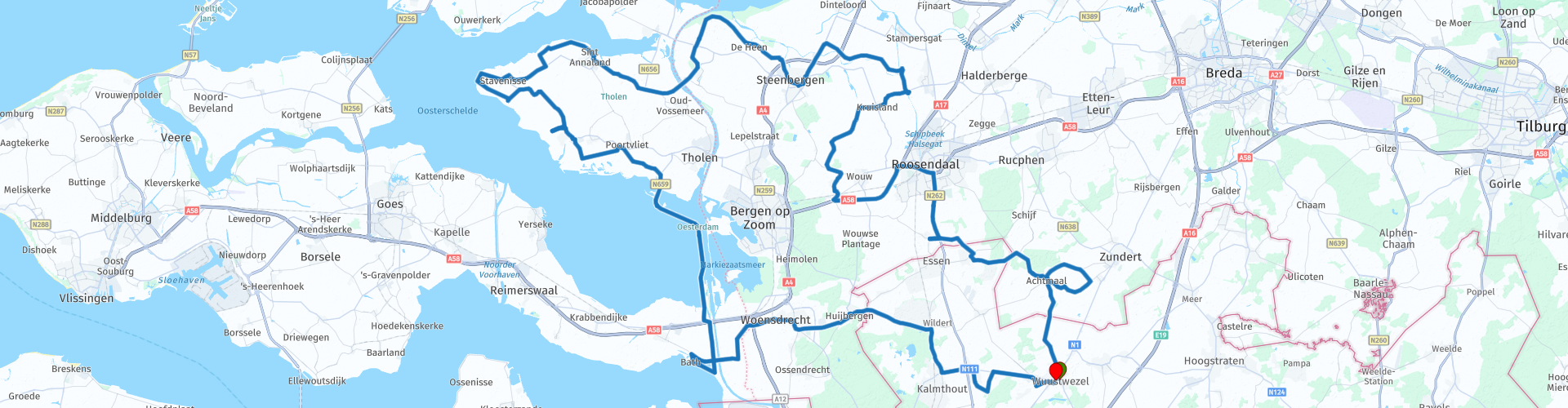
Roundtrip Oosterschelde from Wuustwezel

This route was brought to you by:
RouteXpert Guy Heyns - Adv. RouteXpert
Last edit: 10-12-2024
 Route Summary
 It is a very pleasant, quiet route in which old dikes, mills, farmsteads, medieval town centers, flower fields and modern dike and water technology play the leading role.
All this surrounded by the Oosterschelde National Park. Simple route in which relaxation is central on wonderfully good and open roads.
 Share this route


Animation

Verdict


Duration
4h 20m

Mode of travel
Car or motorcycle

Distance
174.25 km

Countries


 RouteXpert Review
 The departure in Wuustwezel immediately takes you into the middle of the agricultural Kempen landscape and after 5 kilometers (rp3) you will already enter the Dutch province of Noord-Brabant for the first time. On this route you will cross the border between the Netherlands and Belgium four times. Not that it matters much, unless you like to smuggle a few things, which immediately makes you part of the rich history of this region, in which the farmers in particular understood the art of getting a few things illegally across the border in the more difficult times . The many smaller country roads you drive on here certainly played an important role in this whole story.
Shortly after departure you will arrive in Nispen (rp12, km 35), a small village where you can simply take a break on one of the two terraces at the church. Nothing is mandatory, everything is allowed, so if you feel like it, the Gouden Leeuw or café Tivoli are ready for you for a first pleasant break.
However, if you are already ready for a rather hearty bite or you want to experience the Dutch gastronomy up close, you can make a stop 8 km further (rp 13, 43 km) at the 'Pannekoekenbakker' where you can enjoy both sweet and savory pancakes. (or something else). The choice is yours!
Just after rp 19 (refueling option) you drive zigzag along the 'Krommeweg' (what's in a name ...), under the watchful eye of the characteristic church tower of Steenbergen. This zigzagging road is a remnant from the time of the old moats. After all, Steenbergen has developed over time from a settlement on a donk via a walled medieval trading town to a 17th-century fortified town from 1637. In 1827 the fortress was abolished, but before that time it had already fallen into disrepair. Many of the fortifications were demolished, but a number of moats are still present, together with old remains such as at Fort Henricus (rp 22).
You will pass the Schede-Rhine connection and you will also leave the province of Noord-Brabant on route point 26 to reach Zeeland and the island of Tholen.
The history of the Scheldt Rhine connection is a story in itself. Both Belgium and Germany were strongly in favor of such a connection, but it was only in 1963 that the treaty was signed and then it would take another 10 years before the canal was actually opened. The Oesterdam, over which this route later runs, ensured that the canal became tidal-free, but the works are not yet finished. There are plans to build special passage locks in the Volkerakdam, the Philipsdam, the northern part of the Grevelingendam and in the Oesterdam. In this way, the fresh water of the Rhine, the Maas and the Scheldt, via the Scheldt-Rhine Canal, can mix more naturally with the salt water of the North Sea, in fact the Eastern Scheldt. Moreover, this water system can be designed as a retention area for the Great Rivers, with which the effect of climate change can be counteracted. In addition, a solution will be reached for the chronically poor water quality of these waters.
You will be given a first look at the Oosterschelde National Park near Sint-Annaland where you get a view of the Krabbenkreek. The name of Sint-Annaland is also special. After all, in 1475, Charles the Bold gave his half-sister Anna of Burgundy permission to dik a salt marsh area near the island of Tholen. She founded a church and a village, both of which she dedicated to her patron saint, St. Anne.
However, that patroness did not pay close attention on May 23, 1692… The small village was then hit by a fire, which in a short time lost 56 houses, a stove, a brewery and 34 barns. The house where the fire started was then ransacked in blind anger by the inhabitants of the village ... .. so ... if you want to leave the village unharmed, you should behave pretty well ...
A little over half the tour, at rp 31 you arrive in Stavenisse where 't Packhuys' offers you not only pleasant dishes, but also a nice view of the harbor of the village. You can park just next to the terrace or a little further after the Packhuys. Make sure you do not drive into the water. There are no fences to hold you back ...
It is admittedly shortly after the break in 't Packhuys (2km) when it is best to put the engine aside at rp 32 and climb the steep stairs on the dike. After all, at the top you get a particularly wide and impressive view of the entire Eastern Scheldt. Take a moment to take in the special panoramic view, after which you can make your way to Oesterdam via wonderful polder roads.
At rp 37 you start at the entrance to the Oesterdam, the dike that connects the island of Tholen with South Beveland. Pay attention to this! Here you will pass a particularly busy beach that is located just next to the road. Watch out for the many passers-by, young and old ...
When you have passed the lock, you enter the real Oesterdam. The construction of the 10.5 km long dam started in 1979 and ensured, among other things, that the Scheldt-Rhine Canal became tidal-free. The dam is also the direct connection between the island of Tholen and South Beveland.
We leave the Oesterdam and then drive next to the Bathse Spuikanaal, which runs parallel to the Schede-Rhine connection to the Scheldt, if only to give this river some credit. After all, this entire river delta to which both the Eastern and Western Scheldt belong is the source of much of our economic prosperity.
At rp 39 you can see the end of the drainage channel and the Scheldedijk comes into view. At rp 40 you can climb the dike for a moment to take a look at not only the Scheldt itself, but also the drowned Land van Saefthinge on the other side, the port industry of Antwerp and the nuclear power plant of Doel on your left.
Further along the route you can rinse everything again on the terrace of 'Non Plus Ultra' at rp 43, after which you will drive back into Flanders via rp 47 to arrive 19 kilometers later in Wuustwezel, the Kempen village from which you left.
The route is easy to drive and requires no special technical knowledge or special administrative skills. It can therefore also be recommended to the novice rider. But even the more experienced rider will find what they are looking for here because of the exceptionally good and fun, open roads where a lot of special things can be seen. If one is also open to some local facts and the (economic) importance of the region, then a score of 4 is the least one can give, even if only for the natural tranquility that emanates from the island of Tholen and the beauty that both the island and the total route offers you.
Perhaps this island 'Tholen' is the 'loser' of the larger Zeeland, but this route has hopefully made up for it by introducing you to a special island in a special region.


 Links
Links  Usage
Usage Want to download this route?
You can download the route for free without MyRoute-app account. To do so, open the route and click 'save as'. Want to edit this route?
No problem, start by opening the route. Follow the tutorial and create your personal MyRoute-app account. After registration, your trial starts automatically.  Disclaimer
Use of this GPS route is at your own expense and risk. The route has been carefully composed and checked by a MyRoute-app accredited RouteXpert for use on TomTom, Garmin and MyRoute-app Navigation.
Changes may nevertheless have occurred due to changed circumstances, road diversions or seasonal closures. We therefore recommend checking each route before use.
Preferably use the route track in your navigation system. More information about the use of MyRoute-app can be found on the website under 'Community' or 'Academy'.
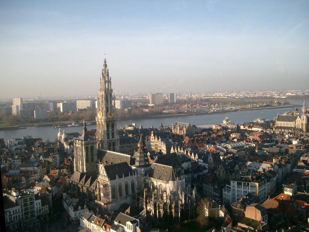
Antwerp Province
About this region
Antwerp Province (Dutch: Provincie Antwerpen [ˈɑntʋɛrpə(n)] (listen)) is the northernmost province both of the Flemish Region, also called Flanders, and of Belgium. It borders on the North Brabant province of the Netherlands to the north and the Belgian provinces of Limburg, Flemish Brabant and East Flanders. Its capital is Antwerp, which includes the Port of Antwerp, the second-largest seaport in Europe. It has an area of 2,876 km2 (1,110 sq mi), and with over 1.85 million inhabitants as of January 2019, is the country's most populous province. The province consists of three arrondissements: Antwerp, Mechelen and Turnhout. The eastern part of the province comprises the main part of the Campine region.
Read more on Wikipedia
View region
 Statistics
  27
27Amount of RX reviews (Antwerp Province)
 36500
36500Amount of visitors (Antwerp Province)
 5460
5460Amount of downloads (Antwerp Province)
 Route Collections in this region
 The 10 most beautiful car and motorcycle routes in South Holland
South Holland, if you say South Holland, you say Rotterdam, you say the Port of Rotterdam, who doesn't know it? But not only this, South Holland is one of the most densely populated and industrialized areas in the world. Yet there is also plenty to do and see for everyone in this province. With 2 large cities, The Hague and Rotterdam, beautiful nature reserves and a rich history, South Holland offers something for everyone.
But apart from being one of the most densely populated and industrialized areas in the world, you can also discover South Holland by car or motorcycle! For this, the MyRoute app RouteXpert has compiled a Top 10 of Car and Motor Routes for you.
All routes in this collection have been checked and made equal for TomTom, Garmin and MyRoute-app Navigation by a RouteRpert MyRoute-app.
If you think so, I have a very nice route that should certainly not be missing from this collection, send it to:
email: routexpert@myrouteapp.com
Subject: New Route for the Top 10 collection Province of South Holland compiled by Hans van de Ven.
The route will then be reviewed and then added to the Top 10. To make the Top 10 also the Top 10, 1 route will have to disappear from the Top 10, you can indicate this when submitting the new route.
Have fun with this collection and while driving one of these routes. Enjoy all the beauty that the Netherlands and in particular the province of South Holland has to offer. Click on “View route” to read the review of the chosen route.
I would like to hear your findings about the route (s).
View Route Collection
The 10 most beautiful car and motorcycle routes in North Brabant
Brabant, Brabant conviviality, bon vivants and who does not know the song by Guus Meeuwis about Brabant? "And then I think of Brabant, because there is still light burning there" and that is true, because the City of Light is in Brabant, in Eindhoven that is, but Eindhoven is also known as the match city of the Netherlands. The annual light festival (GLOW) in Eindhoven shows breathtaking lighting techniques, something you must see once.
But not only light, matches and Brabant cosiness in Brabant, but also a very beautiful province to tour by car or motorcycle and enjoy all the beauty that the province of Brabant has to offer. For this, the MyRoute app RouteXpert has put together a Top 10 of Car and Motorcycle routes for you.
All routes in this collection have been checked and made equal for TomTom, Garmin and MyRoute-app Navigation by a MyRoute-app RouteXpert.
If you think, I have a very nice route that should certainly not be missing from this collection, send it to:
email: routeexpert@myrouteapp.com
Subject: New Route for the Top 10 collection Province of Brabant composed by Hans van de Ven.
The route will then be reviewed and then added to the Top 10.
To make the Top 10 also the Top 10, 1 route will have to disappear from the Top 10, you can indicate this when submitting the new route.
Have fun with this collection and while driving one of these routes. Enjoy all the beauty that the Netherlands and in particular the province of Brabant has to offer. Click on “View route” to read the review of the chosen route.
I would like to hear your findings about the route(s).
View Route Collection