Waterfall tour out of Tongeren via Coo and Reinhardstein

This route was brought to you by:
RouteXpert Guy Heyns - Adv. RouteXpert
Last edit: 10-12-2024
 Route Summary
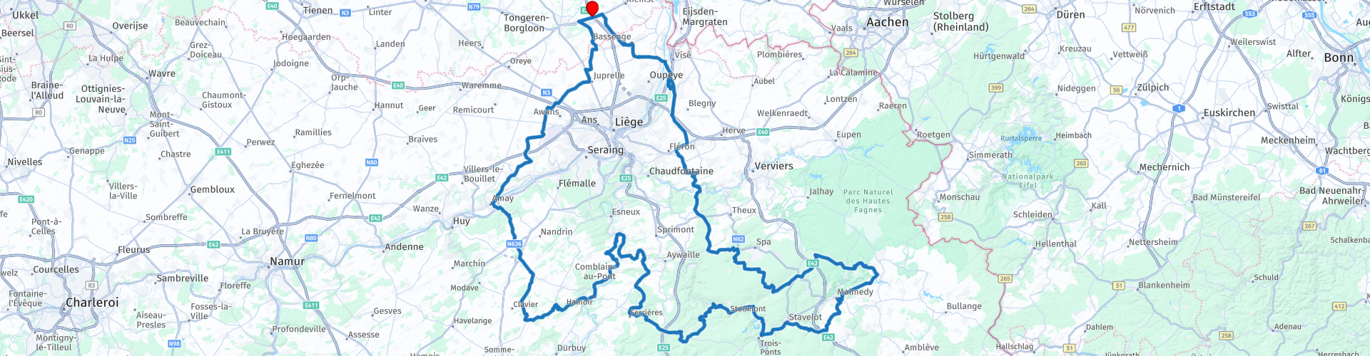
 Please do expect an exciting trip that will take you the whole day to complete if you want to take a stop at least at both waterfalls.
Please also do take into account that the roads are not the easiest ones. If a newbie is with you, then do pay attention to his / her fatigue and take an extra resting point if needed.
Then all will go well and all of you will enjoy this fabulous day trip that takes you across nice places like the Ourthe, the Amblève, Coo, Reinhardstein & Francorchamps, while driving through nice forests & woods on a rollercoaster with 600 meter height differences.
 Share this route


Animation

Verdict


Duration
6h 12m

Mode of travel
Car or motorcycle

Distance
279.26 km

Countries

 RouteXpert Review
 The departure of this tour is near Tongeren, the oldest city in Belgium. The main market there is decorated with a statue of Ambiorix & the Gallo-Roman museum, which enjoys international fame. More information about Tongeren can be found in the route links, but you can count on it that the city of Tongeren itself is more than worth a visit if you are staying in the area.
Shortly after departure at the Pauze, the place of departure and arrival, you will come across a petrol station at route point 2, after which we leave the main road. Almost immediately we dive into the Walloon landscape. Moreover, the speed limit in Wallonia is 90 km / h outside the city and village centers, so motorcycle fun is guaranteed.
The tour actually takes you in a wide circle around Liège. One of the points of contact with this very large city is the former military airport that is now also commercially exploited. (rp 7).
At route point 10 you cross the Maas, a very important river for both Belgium and the Netherlands and also the gate to the motor playground that this route actually is.
From route point 15 it is also best to take a look along the road. You will meet wonderful rivers such as the Ourthe and the Amblève and both will accompany you on this interesting trip. At route point 16 you can take a break along the banks of the Ourthe in 'Le Dilemme' or 'Le Bellevue' ... it is difficult to choose which of the two offers you the best view! (Do you have it?)
After route point 21 we leave the Amblève for a while to concentrate our route by route on the wonderful roads, but you will meet the peak of the Amblève just after rp 28 where you can visit the waterfalls of Coo. Please note, very touristic point as the waterfalls of Coo are the most famous in Belgium. Most people also think it is the highest waterfall in Belgium, but they are definitely mistaken there. The highest waterfall is that of Reinhardstein, which you will pass later on the route.
The Waterfalls of Coo were actually created artificially by the monks of Stavelot Abbey. To provide their water mill with sufficient water, a meander of the Amblève was re-laid and the excess water flowed away over the rocks. This created the waterfalls of Coo. You will find many establishments to take a short break if you wish. If time and energy permit, you can also take the chairlift for a trip to the watchtower, which offers a wonderful view of the surrounding region.
Another, much less known, but nevertheless the highest waterfall in Belgium, the Reinhardstein waterfall, is located 30 kilometers further on the route at route point 32. This 60 meter high waterfall is close to the castle of the same name, which is also open to visitors. and where the Middle Ages revive in words and images. Perhaps you will have to make a choice on this trip to visit one or the other. After all, both are worth it, although the tourist lover will feel more at home in the very touristic Coo region. And if you want a break in between, Malmédy (rp31) is the perfect place for this. Plenty of parking and a great place to stay on the marketplace, which is full of lovely terraces.
Fortunately, the cornering is far from over and the world's most famous cornering is still to come: the Spa-Francorchamps circuit. You almost touch it at route point 36. If you wish, you can take a short stop and visit the world-famous circuit.
But even after this the feast continues. Wonderfully winding asphalt keeps sliding under your wheels, even after you pass the Maas and the Albert Canal, two lifelines of Belgium, just after route point 47.
At route point 50 you will then re-enter Flanders and very quickly reach the end of the route.
The route is absolutely classy material. Not only the road quality, but also the variety, the many attractions and the technicality of the route make the five-star rating of this route absolutely just. However, beware of novice riders. Caution is advised and a fit of overconfidence is better left at home. Both the technicality and the length of the route will demand a lot from every rider. Even more experienced riders will have to admit some fatigue, so a beginner will certainly hit their limits here. No problem if this is acknowledged in time and taken into account. And if that is the case, then that smile in dreamland the night after is really deserved.


 Links
Links  Usage
Usage Want to download this route?
You can download the route for free without MyRoute-app account. To do so, open the route and click 'save as'. Want to edit this route?
No problem, start by opening the route. Follow the tutorial and create your personal MyRoute-app account. After registration, your trial starts automatically.  Disclaimer
Use of this GPS route is at your own expense and risk. The route has been carefully composed and checked by a MyRoute-app accredited RouteXpert for use on TomTom, Garmin and MyRoute-app Navigation.
Changes may nevertheless have occurred due to changed circumstances, road diversions or seasonal closures. We therefore recommend checking each route before use.
Preferably use the route track in your navigation system. More information about the use of MyRoute-app can be found on the website under 'Community' or 'Academy'.
;_vue_de_la_partie_occidentale_du_château-fort_(XIIIe–XIX_siècles).jpg/1280px-Bouillon_(Belgique);_vue_de_la_partie_occidentale_du_château-fort_(XIIIe–XIX_siècles).jpg)
Luxembourg
About this region
Luxembourg (French: Luxembourg [lyksɑ̃buʁ] (About this soundlisten); Dutch: Luxemburg [ˈlyksəmˌbʏrx] (About this soundlisten); German: Luxemburg [ˈlʊksəmbʊʁk] (About this soundlisten); Luxembourgish: Lëtzebuerg; Walloon: Lussimbork), also called Belgian Luxembourg, is the southernmost province of Wallonia and of Belgium. It borders on the country of Luxembourg to the east, the French departments of Ardennes, Meuse and Meurthe-et-Moselle to the south and southwest, and the Walloon provinces of Namur and Liège to the north. Its capital and largest city is Arlon (Luxembourgish: Arel, Dutch: Aarlen), in the south-east of the province.
It has an area of 4,459 km2 (1,722 sq mi), making it the largest Belgian province. With around 285,000 residents, it is also the least populated province, with a density of 64/km2 (170/sq mi), making it a relatively sparsely settled part of a very densely populated region.
It is significantly larger (70%), but much less populous than the neighbouring Grand Duchy of Luxembourg. About eighty percent of the province is part of the densely wooded Ardennes region. The southernmost region of the province is called Gaume or Belgian Lorraine (main city: Virton).
The Arelerland or Arlon region (in red on the map of arrondissements, below) bordering the neighbouring Grand-Duchy of Luxembourg has the particularity that many of its residents have historically spoken Luxembourgish, a language closely related to German, rather than the French or Walloon spoken elsewhere in the province.
The province was separated from the neighbouring Luxembourg by the Third Partition of Luxembourg, de jure in 1830–31 by the Conference of London dealing with the consequences of the Belgian Revolution of 1830, de facto in 1839, after William I, King of the Netherlands and Grand-Duke of Luxembourg, agreed to its decisions and thus the province was given to the newly created Kingdom of Belgium.
Read more on Wikipedia
It has an area of 4,459 km2 (1,722 sq mi), making it the largest Belgian province. With around 285,000 residents, it is also the least populated province, with a density of 64/km2 (170/sq mi), making it a relatively sparsely settled part of a very densely populated region.
It is significantly larger (70%), but much less populous than the neighbouring Grand Duchy of Luxembourg. About eighty percent of the province is part of the densely wooded Ardennes region. The southernmost region of the province is called Gaume or Belgian Lorraine (main city: Virton).
The Arelerland or Arlon region (in red on the map of arrondissements, below) bordering the neighbouring Grand-Duchy of Luxembourg has the particularity that many of its residents have historically spoken Luxembourgish, a language closely related to German, rather than the French or Walloon spoken elsewhere in the province.
The province was separated from the neighbouring Luxembourg by the Third Partition of Luxembourg, de jure in 1830–31 by the Conference of London dealing with the consequences of the Belgian Revolution of 1830, de facto in 1839, after William I, King of the Netherlands and Grand-Duke of Luxembourg, agreed to its decisions and thus the province was given to the newly created Kingdom of Belgium.
View region
 Statistics
  39
39Amount of RX reviews (Luxembourg )
 22390
22390Amount of visitors (Luxembourg )
 8125
8125Amount of downloads (Luxembourg )
 Route Collections in this region
 Route collection MRA NAVIGATION GRAND TOUR 2019
MRA NAVIGATION GRAND TOUR 2019 in short:
From 2019, MyRoute-app organizes every year the "MyRoute-app Navigation Grand Tour" exclusively for MyRoute-app Navigation users. During the Grand Tour you drive 4 routes during the calendar year. A few commands are included in each route. Participants who capture all 4 tracks via MyRoute-app Navigation have the chance to win a great prize. In 2019 we had chosen the 2nd World War as the theme for the 4 routes.
The routes and the assignments:
As mentioned, the theme of 2019 was the 2nd World War. A loaded theme, you are confronted with the dual nature of humanity; the willingness to kill for an ideology, we are better than them, cruelty, slaughter, but also heroism and sacrifices, would it ever change? I myself am very interested in world history, I have even studied it for a year at the university and certainly the 1st and 2nd world war have my interest. So it was no task to put together the routes, drive yourself and come up with the assignments.
Have fun driving these beautiful and interesting routes with a loaded theme!
View Route Collection
5 tours in Belgium in flat Flanders the hills of the Pays des Collines and the Ardennes
Those who like a winding and hilly course, along many small lanes with little to no traffic, will certainly find what they are looking for in the Pays des Collines, the region east and south of Ronse.
Between Diksmuide and Ypres there are many commemorative monuments of the First World War. In Vinkt in East Flanders, the monument commemorates the massacre that took place in May 1940.
Along rural quiet roads you can taste the history of World War I and II.
Marche-en-Famenne is an excellent starting point to thoroughly explore this plateau, which is cut by rivers and strewn with coniferous forests. The real Ardennes are the most hilly areas of Belgium behind the Meuse. Nature plays an all-important role on this trip.
In addition to the Ardennes, the route with start and end point in Huy also goes through a part of Condroz and Famenne. The Condroz, where wooded hills and valleys alternate, and the Famenne, which makes the transition to the Ardennes plateaus. In the summer it is wonderful motorcycling in the vast forests. You will not only enjoy the natural beauty, but you will also pass numerous castles, wild flowing Ardennes rivers, quiet villages and authentic tourist towns.
The tour from Namur runs through the Meuse area where you discover that the tributaries of the Meuse are of picturesque beauty. You will pass a large number of castles and fortresses. The roads along the Maas are busy arterial roads. But as soon as you can you will look for the smaller roads that are immediately a lot quieter and take us through forests and meadows.
View Route Collection