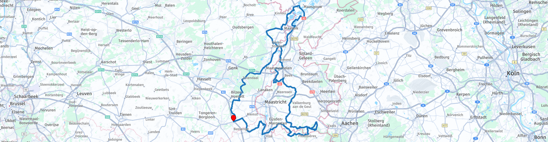
Limburgse Maas tour out of Tongeren via Valkenburg and Thorn

This route was brought to you by:
RouteXpert Guy Heyns - Adv. RouteXpert
Last edit: 10-12-2024
 Route Summary
 The route departs near Tongeren, the oldest city in Belgium. It brings you a surprising and hilly curves that has no equal in the region. The route also passes a number of very beautiful and interesting areas, cities and villages that are more than worth a visit. The Voerstreek, the Limburg hills, Valkenburg, De Maasvallei, Thorn, the 'white' town, the controversial Monastery of Opgrimbie and the Grand Commandery of Alden Biesen are all on the program, as are excellent asphalt that slides under your wheels.
For those who also thought that badges do not exist in Flanders and the Netherlands, this route repeatedly proves the opposite.
But not only the quality of the route, the views, the region or the roads are worth mentioning. The extensive choice of break points, terraces, gastronomy and tourism also make this route a winner.
It is up to you to fully enjoy it.
 Share this route


Animation

Verdict


Duration
6h 4m

Mode of travel
Car or motorcycle

Distance
225.23 km

Countries


 RouteXpert Review
 The starting point is at 'De Pauze' near Tongeren, the oldest city in Belgium.
The facilities of the Pauze (parking, drinks, food, toilet) are particularly well suited for meeting each other as a group. Near Tongeren and also the motorway, so that arrival and departure can be easily organized.
Immediately after departure you will find a petrol station on rp 2. Then you dive into the Limburg agricultural landscape in the direction of the Walloon border, where the curves really begin.
If you wish, you can free up time to visit the Fort of Eben-Emael at route point 6. More information can be found in the attached link, but the story of this - completely built into the mountain - fortress is at least remarkable. The cannons of the Fort have fired just one shot and then as a test. And the Germans only needed one bomb to destroy the entire fort. Bizarre ... and a blot on the Belgian military, moreover ...
After this point, the first two pins will appear. Just before the second, when you leave the high plateau, you will find a beautiful vantage point at route point 7. Many people stop here to enjoy the view, but the parking options are rather limited. You can only park along the edge of the road. However, if you drive in a duo or in a limited group, a short break is certainly possible. In clear weather, you can look at three countries at the same time and get an impression of the economic and military importance of the region.
After the pins you drive over the suspension bridge (enjoy the architecture for a moment) to the zone between the Albert Canal and the 'Maas'. These two lifelines have made a flourishing regional economy possible, also due to the presence of the so-called 'Marl', a very soft limestone with excellent building properties. Many houses in the region are therefore built from this marl stone, quarried in the region itself. Therefore, be careful that you do not suddenly disappear into a hole. Because of the 'mining' of the marlstone, large parts of the region are tunnelled and occasionally a tunnel collapses ...
Two highly recommended 'marl' highlights can be found on this route: the previously mentioned fortress of Eben-Emael and the village of Valkenburg, which is mentioned a little further.
Before arriving in Valkenburg, however, the route takes you through the Belgian Voer region and the Limburg hills. The particularly beautiful Voer region has long been the scene of the battle for the Flemish-Walloon antagonism, a political issue in Belgium. After all, the Voer region is officially Flemish territory, but is completely surrounded by Wallonia. And when Walloon political groups wanted to seize power, the Flemish feeling of struggle erupted. To this day, the Voer is and remains Flemish territory, but the discussion is not over yet.
No matter how beautiful the region is, you should be aware that this Walloon-Flemish contrast is still breeding under the skin. So be very careful if you should broach the subject if you want to enjoy a coffee in café 'De Berwien' just after RP 10. After all, you never know whether you will bump into a 'Flamigant' or a 'Wallon' ... And if you give the 'wrong' opinion to the 'wrong' person, it could just be that you will find it for the rest of the ride with one eye less ... And that would be a real shame on this ride ...
After 'De Berwien' you flirt a number of times with the Belgian-Dutch border. Before finally entering the Netherlands via RP16, you will find the Beusdael castle between RP15 and RP16. The route offers you a beautiful approach to this enchanting castle when you leave the Teuvenerberg Forest Reserve. As you descend the hill, you can take a look several times at this very beautiful castle that - even today - is completely in private hands.
Just after route point 17, the approach is made to the famous loop through the Vijlenerbos. Breathtakingly beautiful. No other words for…. A beautiful qualitative road through a majestic forest in which even a number of pins and a so-called 'hollow' road (RP19) have been incorporated.
Should you see the opportunity, try driving the loop - or even the entire route - on a working day. During the weekend, and certainly in good weather - not only the entire region, but in particular also the Vijlenerbos, is the meeting point for everyone with walking shoes and / or a bicycle. Many tourists know this forest and it is often busy. But don't let this stop you from driving the loop (carefully) anyway. It is therefore best not to cut the loop and you will notice why when you ride it.
Because of the busyness on the loop itself, after the loop, we marked the first three options for a break on the route (RP's 20, 21 and 22). However, there are more to be found in the immediate vicinity. Feel free to stop where there is still a nice spot to be found.
On the way to Valkenburg, the route pampers you even more via the winding and hilly course. You will notice it automatically by the traffic when you approach Valkenburg.
Valkenburg (RP 30) is a fairly large and pleasant city to stretch your legs. Many establishments invite you to take a seat before or after the pleasant marl caves or castle visit, and both are highly recommended. 'Mergelrijk' and the 'Velvet Cave' are just two examples, but the possibilities are endless. For example, the adventurers can even go for a round of 'cave biking' while the creative people attend a workshop in marl studio Aarts. The gourmets will find what they are looking for in the beautiful café on top of the mountain where nice views are their share, assuming of course that the ride had not spoiled them enough in this regard. As a small side note, it should be noted that you should record the engine well in Valkenburg. A forewarned man ...
After Valkenburg the route takes you in the direction of the Maas valley. Where you were allowed to put on a number of pins at the beginning of the route before arriving there, it is no different here. The curves (RP 34) appear very unexpectedly, but are no less pleasant. You will then be 'squeezed' again between the Maas and the Juliana Canal, crossing some very pleasant small villages. Geule aan de Maas, Meers, Berg aan de Maas, Obbicht, Grevenbicht, are just a few nice examples. Via the Maasplassen, vast artificial lakes created by gravel extraction, we reach Thorn, a famous Dutch village.
Thorn was once a mini-kingdom ruled only by women. An abbey and monastery was founded that was not populated by nuns, but by the so-called 'stift' ladies. After all, the Abbey of Thorn was a so-called 'pen', a monastic community in which the rules were interpreted liberally. Rich, noble ladies entered the order pending a marriage with a good party….
The typical white character of the village was created when the French introduced house tax, based on the size of the windows. Immediately, everyone installed smaller windows and the houses were all painted white to hide the masonry. The unique character of the 'white' village acts as a magnet for many artists and tourists who find a warm welcome in Thorn.
After a visit to Thorn, we slowly say goodbye to the Maasplassen and drive towards Maaseik & Stokkem. If desired, a short break can be inserted on the nice market square of Eisden, where there is more than enough parking space, an excellent beer café for the duos and a typical Belgian snack for the hungry.
After crossing the suburbs of Maasmechelen you will reach Opgrimbie where the controversial 'Royal' monastery of Opgrimbie (dis) adorns the forests. After all, when King Baudouin died, he had announced that a monastery had to be built on the Royal domain, in the middle of the 'Hoge Kempen' nature reserve. The necessary building permits were applied for, but never obtained. Despite this, the monastery was built with ministerial permission, but to this day the monastery is disputed and has a bad reputation among many nature lovers.
After route point 63, cross the Albert Canal again and drive in the direction of Bilzen. Just after this town we meander past the Grand Commandery of Alden Biezen, a beautiful castle that has been completely restored and is open to the public and events.
After a short photo stop, you can then drive through the lovely Limburg landscape back to 'De Pauze', where you started the route.
This route deserves the full 5 star rating. Not only because of the road quality, the beautiful views, beautiful small villages and the extensive views, but also because of the surprising elements such as the suddenly appearing pins, the existing 'mountains' in perhaps the flattest country in the world and the historian & natural elements that pop up here and there in the entire story while you traverse the Limburg hills and the Meuse valley. Just like us, you will be pleasantly surprised and a return is certainly not excluded.
Enjoy!


 Links
Links  Usage
Usage Want to download this route?
You can download the route for free without MyRoute-app account. To do so, open the route and click 'save as'. Want to edit this route?
No problem, start by opening the route. Follow the tutorial and create your personal MyRoute-app account. After registration, your trial starts automatically.  Disclaimer
Use of this GPS route is at your own expense and risk. The route has been carefully composed and checked by a MyRoute-app accredited RouteXpert for use on TomTom, Garmin and MyRoute-app Navigation.
Changes may nevertheless have occurred due to changed circumstances, road diversions or seasonal closures. We therefore recommend checking each route before use.
Preferably use the route track in your navigation system. More information about the use of MyRoute-app can be found on the website under 'Community' or 'Academy'.