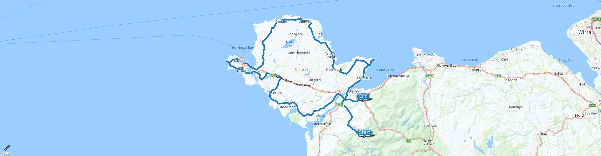
Nant Peris to Tregarth via the Isle of Anglesey

This route was brought to you by:
RouteXpert Nick Carthew - (MRA Master)
Last edit: 13-04-2021
 Route Summary
 I have awarded 4**** stars for this route because of the beautiful countryside, dramatic sea views, quiet roads and good attractions.
 Share this route


Animation

Verdict


Duration
7h 13m

Mode of travel
Car or motorcycle

Distance
181.16 km

Countries

 RouteXpert Review
 Now you will head for the Isle of Anglesey over the historic Menai Bridge situated on the banks of the Menai Strait.
Thomas Telford’s Menai Suspension bridge (Pont Menai), Opened in 1826. The World’s first iron suspension bridge, it is 1,265 feet (305m) long, with a central span of 579 feet (177m) with its roadway set 98 feet (30m) above the water to allow tall ships to sail beneath.
After crossing the magnificent bridge you are now on the Isle of Anglesey. A place of unparalleled beauty with its stunning landscape and sea views. Much of the coastline has been declared 'Areas of outstanding natural beauty'. Anglesey is an historic island full of character, and a place that inspires and appeals to all the senses.
A short ride from the bridge is Beaumaris Castle, situated just beside the road so you'll have a fantastic view of it.
Beaumaris Castle is the great unfinished masterpiece. It was built as one of the 'Iron Ring' of North Wales castles by the English monarch Edward I, to stamp his authority on the Welsh. But it was never finished money and supplies ran out before the fortifications reached their full height. Beaumaris is nonetheless an awesome sight, regarded by many as the finest of all the great Edwardian castles in Wales. Begun in 1295, it was also the last. In pure architectural terms Beaumaris, the most technically perfect castle in Britain, has few equals. Its ingenious and perfectly symmetrical concentric 'walls within walls' design, involving no less than four successive lines of fortifications, was state of the art for the late 13th century.
Further along the coast is Penmon Priory. Penmon’s history stretches back to the 6th century, when a monastery was established here by St Seiriol. The holy well (with reputed healing properties) that bears his name is thought to be associated with this period, though the ‘cell’ that houses it is a much later construction. The remains of the priory that stand today largely date from the 13th century, when it became part of the Augustinian order.
There is a short toll road now that will take you to Penmon Point for some great views across the bay towards Great Orme. Puffin Island is also just off the coast as is the Penmon Lighthouse. There is also the Pilot House Cafe making this an ideal coffee stop while you enjoy the views. You can choose not to visit the priory and Penmon Point by turning left at RP 10 and picking the route up again at RP 14. I have suggested an alternative coffee stop 15 miles on from RP 10.
Enjoy the landscape and occasional coastal views as you head for RP 18, here you'll find the ancient village of Din Lligwy.
The huge blocks of white limestone megaliths that make up this site are striking, even to the most casual visitor. The place has an atmosphere, a feeling of old and of a connection with the old people and the old ways. This Neolithic structure was once described as 'the hill of the old people'. It's just 200m from the roadside and free to visit.
A visit to the north east coast of Anglesey now at Amlwch Port. Amlwch is a major draw for those interested in industrial heritage. Walking around this peaceful town, with its three windmills, it’s hard to imagine that in its mining heyday, it was one of the busiest ports in Wales, and home to nearly 10,000 people. The old harbour at Port Amlwch is well worth a visit with its new copper Kingdom visitor centre.
From here you will pass through the beautiful countryside that is mainly pasturelands often with a view to the sea. You will then hop from one island to another across the Cymyran Strait from Anglesey to Holy Island. It is called "Holy" because of the high concentration of standing stones, burial chambers, and other religious sites on the small island.
Holyhead is where I have suggested a lunch stop, at McDonalds but there are numerous other places to choose from. The origins of Holyhead (Caergybi) date from 450 AD, when Celtic King Caswallon defeated Irish invaders on Holy Island.
The port of Holyhead is the busiest UK Irish ferry port and was home to the largest seagoing ferry in the World.
The Stena Hollandica was launched on 16th May 2010 and was built in the Nordic yards in Germany. It now operates between Hook of Holland and Harwich in England.
A short ride from Holyhead takes you to South Stack.
South Stack is one of Anglesey’s must-see landscapes. It is Anglesey’s most westerly point, lying some 3 miles to the west of Holyhead. The cliffs at South Stack support large colonies of seabirds. The area has an amazing seascape, with magnificent views of the Lleyn Peninsula and Bardsey Island. It is even possible to see Ireland’s Wicklow Mountains on a clear day! The spectacular 300ft (100m) high sea cliffs can be viewed from the path leading to the lighthouse.
Heading back towards the mainland now and you will pass RAF Valley home to No 4 Flying Training School, responsible for training the UK's next generation of world-class fighter pilots. Aircrew are also trained at RAF Valley for mountain and maritime operations throughout the world. You may be lucky to see some aircraft action as you ride by the base.
Crossing over the River Cefni indicates that you only have 20 minutes before you reach the second of the two bridges that connect the Isle of Anglesey to the mainland.
The Britannia Bridge is a twin deck bridge serving both rail and road. The bridge was designed by Robert Stephenson and work began in 1846, Stephenson himself fitted the last rivet of the structure, marking the bridge's official completion in March 1850. As you cross, you will see to your left the Menai Bridge and a very small island with houses on it. This is the Island of Gorad Goch. The name literally translated means ‘the island of red weirs’. The remains of these weirs can be found along the shore of the Menai Straits, but the best examples are found on Gorad Goch itself. The exact date of construction of the remaining weirs on Gorad Goch are not known but are estimated to be around 1824 when a fish smoking chamber was also built on the island. The system works as the weirs are built near eddy currents and therefore water is sucked into the weirs, leaving fish trapped.
The end of the route is at Dinas Farm Touring Park where you can pitch a tent. As an alternative, there are hotels, guest houses and B&Bs; nearby in the town of Bangor.


 Links
Links  Usage
Usage Want to download this route?
You can download the route for free without MyRoute-app account. To do so, open the route and click 'save as'. Want to edit this route?
No problem, start by opening the route. Follow the tutorial and create your personal MyRoute-app account. After registration, your trial starts automatically.  Disclaimer
Use of this GPS route is at your own expense and risk. The route has been carefully composed and checked by a MyRoute-app accredited RouteXpert for use on TomTom, Garmin and MyRoute-app Navigation.
Changes may nevertheless have occurred due to changed circumstances, road diversions or seasonal closures. We therefore recommend checking each route before use.
Preferably use the route track in your navigation system. More information about the use of MyRoute-app can be found on the website under 'Community' or 'Academy'.

Wales
About this region
Wales (Welsh: Cymru [ˈkəm.rɨ] (listen)) is a country that is part of the United Kingdom. It is bordered by England to the east, the Irish Sea to the north and west, and the Bristol Channel to the south. It had a population in 2011 of 3,063,456 and has a total area of 20,779 km2 (8,023 sq mi). Wales has over 1,680 miles (2,700 km) of coastline and is largely mountainous with its higher peaks in the north and central areas, including Snowdon (Yr Wyddfa), its highest summit. The country lies within the north temperate zone and has a changeable, maritime climate.
Welsh national identity emerged among the Britons after the Roman withdrawal from Britain in the 5th century, and Wales is regarded as one of the modern Celtic nations. Llywelyn ap Gruffudd's death in 1282 marked the completion of Edward I of England's conquest of Wales, though Owain Glyndŵr briefly restored independence to Wales in the early 15th century. The whole of Wales was annexed by England and incorporated within the English legal system under the Laws in Wales Acts 1535 and 1542. Distinctive Welsh politics developed in the 19th century. Welsh Liberalism, exemplified in the early 20th century by David Lloyd George, was displaced by the growth of socialism and the Labour Party. Welsh national feeling grew over the century; a nationalist party, Plaid Cymru was formed in 1925 and the Welsh Language Society in 1962. Established under the Government of Wales Act 1998, the Senedd (the Welsh Parliament, formerly known as the National Assembly for Wales) is responsible for a range of devolved policy matters.
At the dawn of the Industrial Revolution, development of the mining and metallurgical industries transformed the country from an agricultural society into an industrial nation; the South Wales Coalfield's exploitation caused a rapid expansion of Wales' population. Two-thirds of the population live in South Wales, including Cardiff, Swansea, Newport and the nearby valleys. Now that the country's traditional extractive and heavy industries have gone or are in decline, the economy is based on the public sector, light and service industries, and tourism. In livestock farming, including dairy farming, Wales is a net exporter, contributing towards national agricultural self-sufficiency.
Wales closely shares its political and social history with the rest of Great Britain, and a majority of the population in most areas speaks English as a first language, but the country has retained a distinct cultural identity. Both Welsh and English are official languages; over 560,000 Welsh-speakers live in Wales, and the language is spoken by a majority of the population in parts of the north and west. From the late 19th century onwards, Wales acquired its popular image as the "land of song", in part due to the eisteddfod tradition. At many international sporting events, such as the FIFA World Cup, Rugby World Cup and the Commonwealth Games, Wales has its own national team. At the Olympic Games, Welsh athletes compete for the UK as part of a Great Britain team. Rugby union is seen as a symbol of Welsh identity and an expression of national consciousness.
Read more on Wikipedia
Welsh national identity emerged among the Britons after the Roman withdrawal from Britain in the 5th century, and Wales is regarded as one of the modern Celtic nations. Llywelyn ap Gruffudd's death in 1282 marked the completion of Edward I of England's conquest of Wales, though Owain Glyndŵr briefly restored independence to Wales in the early 15th century. The whole of Wales was annexed by England and incorporated within the English legal system under the Laws in Wales Acts 1535 and 1542. Distinctive Welsh politics developed in the 19th century. Welsh Liberalism, exemplified in the early 20th century by David Lloyd George, was displaced by the growth of socialism and the Labour Party. Welsh national feeling grew over the century; a nationalist party, Plaid Cymru was formed in 1925 and the Welsh Language Society in 1962. Established under the Government of Wales Act 1998, the Senedd (the Welsh Parliament, formerly known as the National Assembly for Wales) is responsible for a range of devolved policy matters.
At the dawn of the Industrial Revolution, development of the mining and metallurgical industries transformed the country from an agricultural society into an industrial nation; the South Wales Coalfield's exploitation caused a rapid expansion of Wales' population. Two-thirds of the population live in South Wales, including Cardiff, Swansea, Newport and the nearby valleys. Now that the country's traditional extractive and heavy industries have gone or are in decline, the economy is based on the public sector, light and service industries, and tourism. In livestock farming, including dairy farming, Wales is a net exporter, contributing towards national agricultural self-sufficiency.
Wales closely shares its political and social history with the rest of Great Britain, and a majority of the population in most areas speaks English as a first language, but the country has retained a distinct cultural identity. Both Welsh and English are official languages; over 560,000 Welsh-speakers live in Wales, and the language is spoken by a majority of the population in parts of the north and west. From the late 19th century onwards, Wales acquired its popular image as the "land of song", in part due to the eisteddfod tradition. At many international sporting events, such as the FIFA World Cup, Rugby World Cup and the Commonwealth Games, Wales has its own national team. At the Olympic Games, Welsh athletes compete for the UK as part of a Great Britain team. Rugby union is seen as a symbol of Welsh identity and an expression of national consciousness.
View region
 Statistics
  21
21Amount of RX reviews (Wales)
 19057
19057Amount of visitors (Wales)
 2418
2418Amount of downloads (Wales)
 Route Collections in this region
 5 days through Wales on roads less travelled
As the title suggests, this is a 5 day tour through Wales on 'roads less travelled'. Each daily route has spectacular scenery through sometimes, dramatic landscapes. The tour visits some of Wales' well known sights and some not so well known. It travels across open moorland, deep valleys, the mountains of Snowdonia National Park and the beautiful countryside and coast. You will travel over historic bridges and see historic buildings and sights. This truly is an adventurous tour that I am certain you will enjoy.
View Route Collection
Top 10 Downloaded UK routes by RouteXpert Nick Carthew
Hello and welcome to this collection of the Top 10 MyRoute app downloaded routes in the UK.
There will be a great new event to be announced soon, where all these routes can be ridden.
Download them all now and place them in a new "Top 10" folder, so that you always have them at hand.
If you are going to drive one of these routes in the meantime, track them with the MRA Mobile App or with MRA Navigation. Take some photos (moments) along the way as these will come in handy.
Create a travelstory of your Top 10 driven routes and add the recorded track to it.
There will also be some great prizes on offer, so keep an eye on the MRA-RouteXperts page and your email.
View Route Collection