TTT 2017 04 Rondje Vulkaaneifel vanuit Slenaken

This route was brought to you by:
RouteXpert Hans van de Ven (Mr.MRA)
Last edit: 15-04-2021
 Route Summary
 This TTT are touring through the Netherlands with the occasional trip to Belgium, Germany or even Luxembourg, which are driven 6 to 7 times a year. The 1st around March and the last around October. These TTTs have a starting point, a pause location and an end point. It is nice to discover what you have not seen in your own country and which nice roads you did not know before.
This TTT is from 2017, so the route may differ slightly from the original.
I have checked all route points and, where necessary, placed them neatly on the road. Also, if necessary, I have further set the starting point and end point of the route a little further apart to prevent navigation to the end point directly and added the POI files of the start and end point, as well as possible pause location (s).
Finally, I made the route the same for TomTom, Garmin and MRA Navigation users.
Thanks to ANWB / Promoter.
 Share this route


Animation

Verdict


Duration
4h 53m

Mode of travel
Car or motorcycle

Distance
245.86 km

Countries


 RouteXpert Review
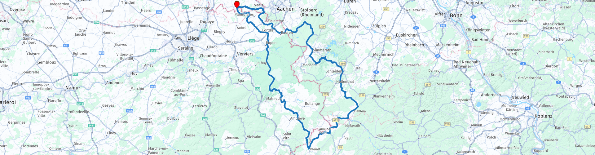
 Eifel motorcycle paradise is just a stone's throw from the Netherlands. You can enjoy curves, rolling landscapes, beautiful villages and romantic castles. You start in Slenaken, and drive south through towns such as Heyenrath, Vaals and Moresnet. Not long afterwards you will drive along the north side of the High Fens to the German town of Kronenburg, where we will photograph you at Restaurant Pfeffer und Salz. Nach Mittagessen goes the route straight through the High Fens of Belgium back to Slenaken. (Source: Promoter 05-2017).
Because I have driven this route myself, this route gets 5 stars.
General information:
Start & end point: De Slenakervallei, Dorpsstraat 1, Slenaken.
The Hoge Venen are part of the Hoge Venen-Eifel nature park. The High Fens are located on a plateau, largely in the Ardennes and to a smaller extent in the Eifel. It is located in Wallonia in eastern Belgium, there in the province of Liège, and in a bit of neighboring Germany.
The Eifel is the eastern part of the middle-high plateau of the Eifel-Ardennes. It lies north of the Moselle and west of the Rhine. The largest part is in Germany, a small part is in Belgium, in the East Cantons. The German part of Eifel is located in the states of North Rhine-Westphalia and Rhineland-Palatinate.


 Links
Links  Usage
Usage Want to download this route?
You can download the route for free without MyRoute-app account. To do so, open the route and click 'save as'. Want to edit this route?
No problem, start by opening the route. Follow the tutorial and create your personal MyRoute-app account. After registration, your trial starts automatically.  Disclaimer
Use of this GPS route is at your own expense and risk. The route has been carefully composed and checked by a MyRoute-app accredited RouteXpert for use on TomTom, Garmin and MyRoute-app Navigation.
Changes may nevertheless have occurred due to changed circumstances, road diversions or seasonal closures. We therefore recommend checking each route before use.
Preferably use the route track in your navigation system. More information about the use of MyRoute-app can be found on the website under 'Community' or 'Academy'.