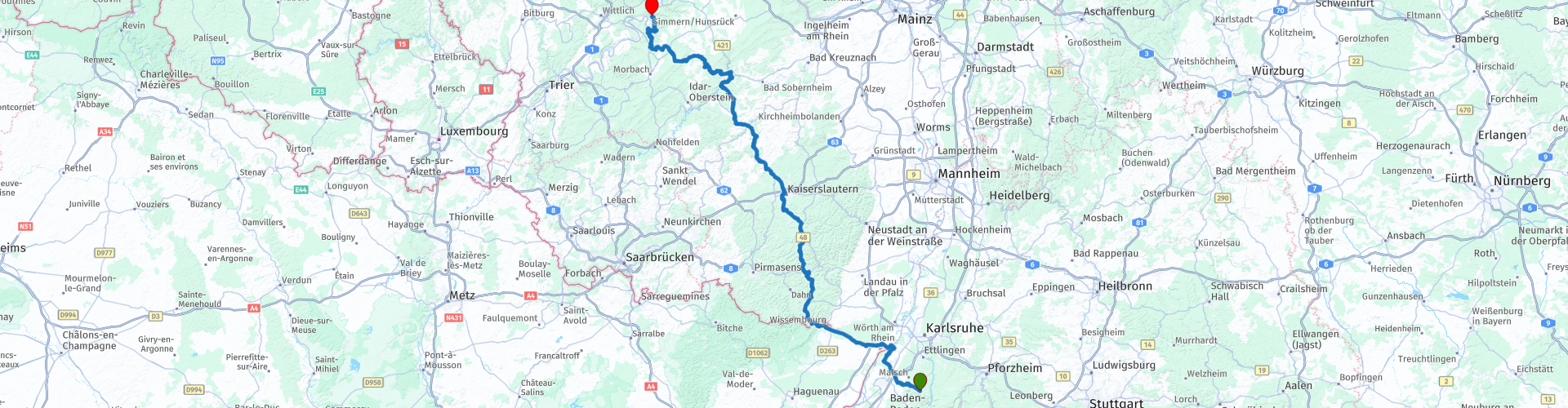
18 From Moosbronn to Enkirch via the Pfalz and Mosel

This route was brought to you by:
RouteXpert Leonor Orban - Sr. RouteXpert
Last edit: 05-02-2021
 Route Summary
 For many, the route will increasingly pass through familiar terrain. From Moosbronn (Black Forest) you cross the Rhine fairly quickly to enter France, after which you enter the Palatinate Forest via Wissembourg.
A fast route eventually leads you into the Moselle to your final destination today: Hotel Dampfmuhle in Enkirch.
Along the way, it is especially wonderful to enjoy the easy to drive and well-paved winding roads. Here and there a few small trips are included to stretch the legs. Consider, for example, a walk to the Luitpoldturm, the Nahy Skywalk and Castle Dhaun. There are also plenty of options to enjoy a delicious drink and a drink. For these reasons, the route receives 4 stars.
 Share this route


Animation

Verdict


Duration
7h 28m

Mode of travel
Car or motorcycle

Distance
255.19 km

Countries

 RouteXpert Review
 The 18th stage of the tour through the Alps and Eastern Europe goes from Moosbronn in the Black Forest to Enkirch on the Moselle. The route is based on a journey that Marc Telkamp set out and drove in 2015.
After a good night's sleep comes a delicious breakfast. Take your time and enjoy a cup of coffee or tea before the journey begins. Today a simple route is planned. The distance is not too long, the roads wind wonderfully through the landscape and along the way there are plenty of beautiful impressions to be gained thanks to the beautiful and varied landscape and a number of nice stops.
After your departure from Moosbronn you drive out of the Black Forest fairly quickly to enter the lowlands of the Rhine. This lowland was created about 35 million years ago after an elongated subsidence of the earth's crust. The Vosges and the Black Forest were thus separated from each other and the Rhine also found its way here due to the depth of the area. In Neuburg am Rhein you cross the river by ferry (rp 4). For more information you can visit the website of the ferry service.
Soon after the crossing you enter the most north-eastern point of France. The route will soon follow its path along the border to Wissembourg (rp 7). The city, founded around 800 AD, has formed around a monastery and has grown over the centuries to its current size. The city has also changed nationality countless times. Started as the German Weissemburg (white castle), then French, then again German ... French ... German ... And nowadays French again, with the honorary title "Gateway to the Vosges".
Despite the turbulent history in the region, the old town has been well preserved. Several old buildings tell the story of this region and therefore make a walk through this town very pleasant. Along the way you will also come across plenty of opportunities to take a break on a terrace.
Once bored in Wissembourg, the tour begins towards the Pfälzerwald in Germany. Immediately after the border crossing you will pass the Europa-Denkmal (rp 9) where you can stop for a photo or, for those who have not stopped in Wissembourg, to take a break at Waldrestaurant Sankt Germanshof.
The Palatinate Forest (with an area of 1771km2), together with the Vosges Mountains in France, form the UNESCO-registered Palatinate Forest - North Vosges Biosphere Reserve. This makes it one of the largest forest areas in Europe. And you will also notice that on the road. How wonderfully winding the roads are, often your view will be a thick and dark forest. Fortunately, the Luitpoldsturm (rp 11) offers a nice break from this cadence. You can walk to the tower from the parking lot along the route. It stands at an altitude of 611m on the top of the Weißenberg. In good weather you not only have a spectacular view of the forests of the Palatinate Forest, but also the Vosges and the Black Forest in the distance.
Such a walk can arouse hunger and thirst. Not much further you come through the village of Schwarzbach (rp 12) where you can choose. You can take a break at Gasthof Johanniskreuz or Cafe Nicklis. The first is directly along the route and can therefore sometimes be busy. If there is no space there, you can keep left in the village at a y-junction, deviate briefly from the route and settle down at Cafe Nicklis.
After the break, the route continues through the forest towards Kaiserslautern. Once you have crossed the city, the stretch through the Hunsrück begins. This low mountain range was volcanic in the distant past. Air bubbles formed in the lava, around which crystals again formed. In the 20th century, these crystals were dug up to work and to sell as gemstones. Nowadays there is also a tourist route through this area named after these activities: the German Gemstone Route. Great inspiration for a new road trip!
In the Hunsrück you will also come across a number of beautiful sights. You will drive past Kirn and see on a lonely mountain Schloss Kyrburg (rp 18), where nowadays a special whiskey museum is housed. Because it is difficult to taste Whiskey while riding a motorcycle, we leave the museum for now and look for another exciting activity. A little further on the route you will pass St. Johanniskreuz (rp 19). From the parking lot it is about a 300 meter walk to the Nahe Skywalk. It hangs about 70 meters above the Nahe valley. Enjoy the valley through which you just drove and then a short continuation of the route to stop a little further at Schloss Dhaun (rp 20).
This castle was built in the 12th century and has been owned by German nobility. In 1794 the French conquered the area including the castle. The soldiers sold the castle and the new owners broke it down to use the building materials elsewhere. For decades, a ruin stood here until a new owner decided to renovate the castle. There is still plenty of work to do, but the castle has been restored to some extent. You can visit the castle or settle down on a terrace on the other side of the parking lot and admire the view of the castle. The end point is about an hour away, so a break to get some energy for the last part is a good choice.
And you absolutely want to drive that last part with full attention. The winding roads from Dhaun to near Traben-Trarbach are a pure pleasure. The bends just keep on coming, even a good number of hairpin bends have to be overcome.
And then there is a little surprise at the end. At Starkenburg (rp 27) you get high enough and you have a spectacular view over the Moselle. In the right season, the vines on the steep walls along the Moselle are in full bloom and the valley turns a beautiful green.
After this view, the Moselle disappears behind the trees again and you descend to the village of Enkirch. Here the route ends at Moselromantik-Hotel Dampfmühle (rp 28). The owners were also "Winzer" themselves in the young past and would like to welcome you in their hotel with a glass of wine of their own making.
With the motorbike safely “in the stable” in the barn and a delicious dinner on the greenhouse, overgrown with grape vines, you will hopefully look back on a beautiful day.


 Links
Links  Usage
Usage Want to download this route?
You can download the route for free without MyRoute-app account. To do so, open the route and click 'save as'. Want to edit this route?
No problem, start by opening the route. Follow the tutorial and create your personal MyRoute-app account. After registration, your trial starts automatically.  Disclaimer
Use of this GPS route is at your own expense and risk. The route has been carefully composed and checked by a MyRoute-app accredited RouteXpert for use on TomTom, Garmin and MyRoute-app Navigation.
Changes may nevertheless have occurred due to changed circumstances, road diversions or seasonal closures. We therefore recommend checking each route before use.
Preferably use the route track in your navigation system. More information about the use of MyRoute-app can be found on the website under 'Community' or 'Academy'.

Rheinland Pfalz
About this region
Rhineland-Palatinate (German: Rheinland-Pfalz, [ˈʁaɪ̯nlant ˈp͡falt͡s] (listen)) is a western state of Germany. It covers 19,846 km2 (7,663 sq mi) and has about 4.05 million residents. It is the ninth largest and sixth most populous of the sixteen states. Mainz is the capital and largest city. Other cities are Ludwigshafen am Rhein, Koblenz, Trier, Kaiserslautern and Worms. It is bordered by North Rhine-Westphalia, Saarland, Baden-Württemberg and Hesse and by the countries France, Luxembourg and Belgium.
Rhineland-Palatinate was established in 1946 after World War II, from parts of the former states of Prussia (part of its Rhineland province), Hesse and Bavaria (its former outlying Palatinate kreis or district), by the French military administration in Allied-occupied Germany. Rhineland-Palatinate became part of the Federal Republic of Germany in 1949 and shared the country's only border with the Saar Protectorate until the latter was returned to German control in 1957. Rhineland-Palatinate's natural and cultural heritage includes the extensive Palatinate winegrowing region, picturesque landscapes, and many castles and palaces.
Read more on Wikipedia
Rhineland-Palatinate was established in 1946 after World War II, from parts of the former states of Prussia (part of its Rhineland province), Hesse and Bavaria (its former outlying Palatinate kreis or district), by the French military administration in Allied-occupied Germany. Rhineland-Palatinate became part of the Federal Republic of Germany in 1949 and shared the country's only border with the Saar Protectorate until the latter was returned to German control in 1957. Rhineland-Palatinate's natural and cultural heritage includes the extensive Palatinate winegrowing region, picturesque landscapes, and many castles and palaces.
View region
 Statistics
  132
132Amount of RX reviews (Rheinland Pfalz)
 41219
41219Amount of visitors (Rheinland Pfalz)
 24540
24540Amount of downloads (Rheinland Pfalz)
 Route Collections in this region
 Top 5 Car and Motorcycle Routes in the Eifel
The Eifel is the eastern part of the medium plateau Eifel-Ardennes. It is located north of the Moselle and west of the Rhine. The largest part is in Germany, a small part is in Belgium, in the East Cantons. The German part of Eifel is located in the federal states of North Rhine-Westphalia and Rhineland-Palatinate. The highest point is the Hohe Acht with 747 meters.
Several chains can be distinguished in the Eifel:
The northernmost part is called the Nordeifel, which in Belgium connects to the High Fens;
To the east of this is the Ahrgebirge, this part is located north of the Ahr in the Ahrweiler district;
South of the Ahr is the Hohe Eifel (or Hocheifel), of which the Hohe Acht (747 m) is the highest point, and also the highest point in the entire Eifel region;
To the west, near the Belgian border, the hills are known as Schneifel, part of the wider Snow Eifel area with peaks reaching up to 698 metres;
South and east of the Hohe Eifel is the Volcano-Eifel, a volcanic area with many crater lakes (Maare).
The southern part of the Eifel is less high. The area is bisected by streams and rivers running southwards. These streams flow into the Moselle. The largest of these rivers is the Kyll; the hills around this river are known as the Kyllwald;
In the south, the Eifel ends in the Voreifel.
In the north of the Eifel there are some large reservoirs. The largest of these is the reservoir in the Roer that was created by the construction of the Roerdal dam.
The Nürburgring is also located in the Eifel, a well-known car circuit for Formula 1 races, among other things. Since 2004, part of the north of the Eifel has become the Eifel National Park. This National Park falls entirely within the German-Belgian nature park High Fens-Eifel. Another part of the Eifel falls within the South Eifel Nature Park.
Well-known throughout the Netherlands and Belgium by car and motorcyclists, so reason enough for the MyRoute app RouteXpert to compile a Top 5 of Car and Motorbike routes for you.
All routes in this collection have been checked and made equal for TomTom, Garmin and MyRoute-app Navigation by a MyRoute-app RouteXpert.
If you think, I have a very nice route that should certainly not be missing from this collection, send it to:
email: routeexpert@myrouteapp.com
Subject: New Route for the Top 5 collection Eifel composed by Hans van de Ven.
The route will then be reviewed and then added to the Top 5. To make the Top 5 also the Top 5, 1 route will have to disappear from the Top 5, you can indicate this when submitting the new route.
Have fun with this collection and while driving one of these routes. Enjoy all the beauty that the Eifel has to offer. Click on “View route” to read the review of the chosen route.
I would like to hear your findings about the route(s).
View Route Collection
Route collection hairpins in the Eifel
This collection is composed of the most beautiful and winding roads in the Eifel. Forget Bundesstraßen, forget the road along the Moselle, if you have driven these roads, you can really say that you have been to the Eifel.
No less than 6 routes and 1,800 kilometers are waiting for you!
No less than 6 routes and 1,800 kilometers are waiting for you!
View Route Collection