01 Santander to Potes

This route was brought to you by:
RouteXpert Nick Carthew - (MRA Master)
Last edit: 02-04-2025
 Route Summary
  Share this route


Animation

Verdict


Duration
5h 59m

Mode of travel
Car or motorcycle

Distance
224.51 km

Countries

 RouteXpert Review
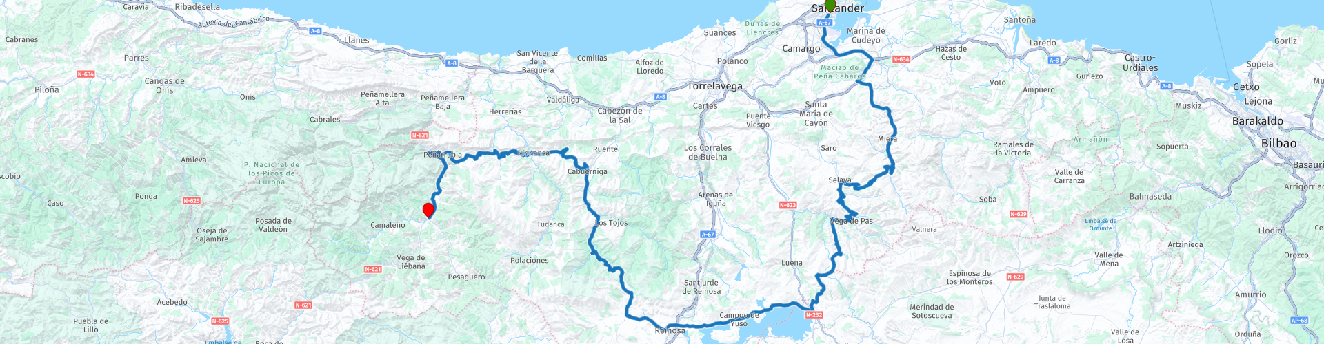
 The route uses the S10 to quickly get you away from the chaos of the busy ferry port and it is a little unconventional because it takes you south, via the enormous Ebro Reservoir where most other routes would take you on the A-67 and A-8 motorways to head west out of Santander.
This route is all about the roads and views and after only 15 minutes of leaving you will be in the Spanish countryside and a further 30 minutes and you'll be encountering mountain roads and hairpin bends.
The Cantabrian Mountain range is one of the main systems of mountain ranges in Spain. They stretch for over 300 km across northern Spain, from the western limit of the Pyrenees to the Galician Massif in Galicia, along the coast of the Cantabrian Sea.
The twisty roads are a natural playground for motorcycles with stunning views on nearly every corner.
There are several places to stop for pictures as indicated by the green route point markers but to be honest, the views are fantastic along most of this route.
I have suggested a food or coffee stop on the banks of the mighty Ebro Reservoir. The Ebro reservoir was finished by Franco in 1945 to provide better water supplies to areas downriver. The remains of 9 villages lie beneath the waters, although several were relocated to shore level. It’s a drive of around 60km and around an hour to circumnavigate the lake, and makes an interesting trip with many things to stop off and see. (Worth remembering)
You start to head north after the reservoir and you are soon at Puerto de Palombera, at 1260 metres it is the highest part of this route. It is also set within the Saja-Besaya Natural Park and area that contains some of the best forests in Cantabria, which provide shelter to a valuable fauna, including deer, roe deer, wild boar, wolves, chamois, various birds of prey, occasionally a brown bear! Keep your eyes peeled.
The final road into Potes contains the Desfiladero de La Hermida, an amazing gorge and at 20 km long it is the longest in the Iberian Peninsula. The river Deva runs through its interior, flanked by rock walls that reach 600 meters in height, which makes the gorge a true scenic spectacle and a great way to end day one of this nine day tour.
There are lots of hotels and all sorts of accommodation at Potes, I have included links for just a few below this review.
Enjoy.


 Links
Links  Usage
Usage Want to download this route?
You can download the route for free without MyRoute-app account. To do so, open the route and click 'save as'. Want to edit this route?
No problem, start by opening the route. Follow the tutorial and create your personal MyRoute-app account. After registration, your trial starts automatically.  Disclaimer
Use of this GPS route is at your own expense and risk. The route has been carefully composed and checked by a MyRoute-app accredited RouteXpert for use on TomTom, Garmin and MyRoute-app Navigation.
Changes may nevertheless have occurred due to changed circumstances, road diversions or seasonal closures. We therefore recommend checking each route before use.
Preferably use the route track in your navigation system. More information about the use of MyRoute-app can be found on the website under 'Community' or 'Academy'.