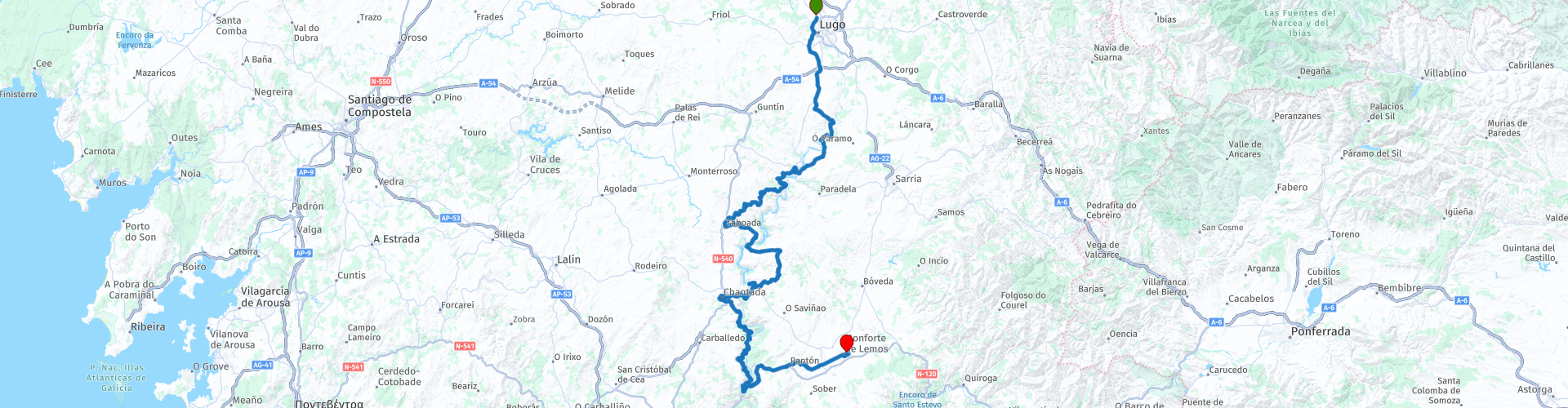
The road from Lugo to Monforte de Lemos along the Mino River

This route was brought to you by:
RouteXpert Jordi honrubia (RouteXpert)
Last edit: 14-02-2025
 Route Summary
  Share this route


Animation

Verdict


Duration
10h 39m

Mode of travel
Car or motorcycle

Distance
166.85 km

Countries

 RouteXpert Review
 Starting in Lugo, for which it is advisable if possible to come a day before to do some tourism in Lugo where you can enjoy a little bit of everything in this beautiful city, both its history, the oldest in Galicia, as well as its heritage and its gastronomy.
Lugo:
We will go out on this First Route of Lugo, which is recommended if possible to come a day before to do some sightseeing in Lugo where you can enjoy a little bit of everything in this city, both its history, the oldest in Galicia, its heritage and its gastronomy.
One of the best things to do in Lugo is to cross the wall through one of its old gates such as Porta Miñá, which is preserved in a more original state.
This gate and the other 9 that gave access to the old Roman walled city were built at the end of the 3rd century when the Roman Empire needed to protect itself from the incursions of barbarian peoples.
The Porta Miñá or del Carmen, whose name comes from the exit to the Miño, is also the departure point for pilgrims heading to Santiago de Compostela following the Camino Primitivo, a variant of the Camino de Santiago that leaves from Oviedo.
This wall, 2,266 metres long and declared a World Heritage Site by UNESCO, is the only Roman wall in the world that is preserved intact around its entire perimeter, making it one of the most important historical monuments in the entire peninsula.
Gastronomy: The vast majority of bars and taverns in Lugo offer a free tapa with every drink or glass of wine.
Portomarin:
The town of Portomarín, located in the province of Lugo, on the banks of the Miño River, it retains the characteristics of the traditional Galician village, with arcades, cobbled streets and low houses, which gives it a special charm. Formerly, the town was located in a valley, but due to the construction of a reservoir in the 1960s, the town was under the waters of the Miño River and was moved to a nearby hill. This move made Portomarín a unique place, where you can enjoy stunning panoramic views of the reservoir and the surrounding area. The municipality is known for being an important stop on the Camino de Santiago. Pilgrims often enjoy local hospitality, rest in cozy hostels and explore the charming cobbled alleys of Portomarín.
After Portomarin we will continue along very narrow and entertaining roads, which border the Miño river and its vineyards with many viewpoints which are beautiful to enjoy.
Taboada:
Taboada is located at the foot of the O Faro mountain range on the western side of the Belesar reservoir. Native oak and chestnut forests predominate, as well as agricultural areas and vine cultivation on the banks. Its Festivals Festa do Caldo de Ósos ("Bone Broth Festival"). "Bone broth" is a typical Taboada dish that enjoys a certain fame throughout Galicia. It is a broth made with the backbone of the pig, chickpeas, potatoes, brains, a sauté of oil, garlic and paprika and hot pepper to taste. Since the 90s this festival of gastronomic exaltation has been celebrated.
Mirador de Taboada:
Viewpoint over the Belesar reservoir, on the Miño River, with attractive views of the vineyard terraces. From the viewpoint you can see Ponte Mourulle, popularly known as the "screw bridge", due to the construction technique used. A short distance away is also the Ponte Mourulle nautical club, with magnificent facilities for practicing water sports.
Mourulle Bridge:
A 270-metre bridge on the banks of the Miño. It is a structure that joins the banks of the Miño River, in a natural and cultural environment of great importance in Galicia. A work of art and engineering Built in 1969 by the engineer José Antonio Torroja Cabanillas, father of the renowned singer Ana Torroja of the group Mecano, the Mourelle Bridge is much more than a physical connection between the parishes of San Xián de Ínsua and San Vicente de Mourulle. Made up of three spans, with the central one standing out with a span of 156 metres. Its metal structure design gives it a modern and elegant air, affectionately earning it the nickname "a ponte dos parafusos" or "bridge of screws".
Belesar Reservoir and its Hydroelectric Plant:
Belesar is one of the many artificial reservoirs built during the Franco military dictatorship for the development of hydroelectric energy through mini-power plants.
In August 1957, work began on this giant concrete reservoir, which included the diversion of the Miño River. It has a capacity of 655 hm3, making it the largest of the artificial reservoirs on the Miño. At its deepest point, it reaches a height of 135 metres.
The harsh conditions of its construction. More than 3,500 people worked on its construction for 5 years, 24 hours a day in shifts; another 2,000 worked indirectly in two 12-hour shifts a day. Many of those who worked on its construction were political prisoners who lived in very harsh conditions.
The construction of the Belesar reservoir left several towns under water, including Portomarín; Only its medieval part, which had been declared a Historic-Artistic Site in 1946, was saved from being devastated, changing its location to its current location. The Romanesque church of San Xoan, also known as San Nicolás, or the “Casa del General” among other notable monuments, was moved stone by stone.
Chantada:
Between the Miño Canyon and the Galician Ridge with Monte Faro as its summit, its beautiful old town and the numerous examples of Romanesque architecture in the town stand out.
The geographical location of the municipality presents it as “the heart of Galicia”, and it has a variety of landscapes, mixing the mountains and the riverbank. Among its attractions we would add an impressive and abundant Historical Artistic Heritage where Romanesque is present to a large extent.
The origin of the name of Chantada is linked by many authors to “Plantata”, probably in relation to an old defensive fortification.
Its old town preserves traditional arcades, especially in Rúa do Comercio.
I have suggested a lunch stop here at restaurant Os Pendellos where you’ll find a great selection of homemade local dishes.
Church of Santa María de Nogueira de Miño:
The church stands at the top of the famous Cabo do Mundo meander. Santa Maria de Nogueira combines parts of the second half of the 12th century and late 18th century, a time when significant work was done on the façade, which now features the old Romanesque rose window and bell tower, and baroque shapes. Inside are some impressive Renaissance paintings, which were restored in the second decade of the 21st century and have earned it the nickname of the Galician Sistine Chapel. They are frescoes on lime mortar and sand. In the section of the apse you can see the scene of the Kiss of Judas, on the left panel, on the right a scene of the Via Crucis, and on the ceiling the four winds together with the moon and the sun.
Panton:
Panton is a small town whoose geographical boundaries are determined by the rivers Miño, Cabe and Sil, which make Pantón the Galician Mesopotamia! Until the 1990s, we can say that this municipality was very prosperous thanks to commerce, especially meat, since this sector was focused on the main street of Ferreira de Pantón, where the old national road 120 ran. With the creation of the current highway, Pantón lost a lot of business and, therefore, purchasing power. The main feature of Panton is a monastery called the Monasterio Cisterciense de Ferreria. This monastery is only a short walk from the town center and it offers an unusual experience for those who are able to speak some Spanish.
Monasterio Cisterciense de Ferreria:
The only female monastery that still preserves monastic life in the whole of Ribeira Sacra, also known as the Monastery of the Bernardas. It was founded in the 10th century as a double monastery and remained so until this type of monastery was suppressed in the 12th century. In 1175 it was annexed to the Cistercian order and a new stage of spiritual and economic renewal began. The nuns keep inside the monastery an image of a Virgin and Child, Romanesque from the end of the 12th century or beginning of the 13th century.
Monforte de Lemos:
The route ends in the city of Monforte de Lemos, located in between the valleys of the Miño River and the Sil River, in the south of Lugo. It is an important city in Galicia, and it is one of the places you can find on the Way of Saint James, one of the many different routes that lead you to Santiago de Compostela's Cathedral, where Saint James' tomb is located.
The city grew around the 10th-century Benedictine Abbey of San Vicente del Pino (now a hospital) and became the capital of the county of Lemos in the 12th century. Dominating Monforte is the medieval keep of the counts, built on the site of a Roman camp.
You won't want to miss a visit to the Colegio de Los Escolapios (Piarist School), a majestic building more than 100 meters in length. Construction of the structure was begun in 1593 and completed in 1913, after more than three centuries of work. Its grandeur evokes El Escorial Monastery and its walls bear the coats of arms of the counts of Lemos, the House of Alba and the Piarist Fathers, who were responsible for completing the work. The school's museum, previously the sacristy, houses paintings by El Greco and Andrea del Sarto, among others.
Monforte de Lemos is also an exceptional location for exploring the Ribera Sacra region, with its rivers, vineyards, Romanesque churches, gastronomy and festivals. In the area around the town you will discover indescribably beautiful landscapes, including the Sil River Canyon and the magical Sierra de O Caurel mountains.


 Links
Links  Usage
Usage Want to download this route?
You can download the route for free without MyRoute-app account. To do so, open the route and click 'save as'. Want to edit this route?
No problem, start by opening the route. Follow the tutorial and create your personal MyRoute-app account. After registration, your trial starts automatically.  Disclaimer
Use of this GPS route is at your own expense and risk. The route has been carefully composed and checked by a MyRoute-app accredited RouteXpert for use on TomTom, Garmin and MyRoute-app Navigation.
Changes may nevertheless have occurred due to changed circumstances, road diversions or seasonal closures. We therefore recommend checking each route before use.
Preferably use the route track in your navigation system. More information about the use of MyRoute-app can be found on the website under 'Community' or 'Academy'.
Galicia
About this region
Galicia (; Galician: Galicia [ɡaˈliθjɐ] or Galiza [ɡaˈliθɐ]; Spanish: Galicia, Portuguese: Galiza) is an autonomous community of Spain and historic nationality under Spanish law. Located in the northwest Iberian Peninsula, it includes the provinces of A Coruña, Lugo, Ourense and Pontevedra.
Galicia is located in Atlantic Europe. It is bordered by Portugal to the south, the Spanish autonomous communities of Castile and León and Asturias to the east, the Atlantic Ocean to the west, and the Cantabrian Sea to the north. It had a population of 2,701,743 in 2018 and a total area of 29,574 km2 (11,419 sq mi). Galicia has over 1,660 km (1,030 mi) of coastline, including its offshore islands and islets, among them Cíes Islands, Ons, Sálvora, Cortegada Island, which together form the Atlantic Islands of Galicia National Park, and the largest and most populated, A Illa de Arousa.
The area now called Galicia was first inhabited by humans during the Middle Paleolithic period, and takes its name from the Gallaeci, the Celtic people living north of the Douro River during the last millennium BC. Galicia was incorporated into the Roman Empire at the end of the Cantabrian Wars in 19 BC, and was made a Roman province in the 3rd century AD. In 410, the Germanic Suebi established a kingdom with its capital in Braga (Portugal); this kingdom was incorporated into that of the Visigoths in 585. In 711, the Islamic Umayyad Caliphate invaded the Iberian Peninsula conquering the Visigoth kingdom of Hispania by 718, but soon Galicia was incorporated into the Christian kingdom of Asturias by 740. During the Middle Ages, the kingdom of Galicia was occasionally ruled by its own kings, but most of the time it was leagued to the kingdom of Leon and later to that of Castile, while maintaining its own legal and customary practices and culture. From the 13th century on, the kings of Castile, as kings of Galicia, appointed an Adiantado-mór, whose attributions passed to the Governor and Captain General of the Kingdom of Galiza from the last years of the 15th century. The Governor also presided the Real Audiencia do Reino de Galicia, a royal tribunal and government body. From the 16th century, the representation and voice of the kingdom was held by an assembly of deputies and representatives of the cities of the kingdom, the Cortes or Junta of the Kingdom of Galicia. This institution was forcibly discontinued in 1833 when the kingdom was divided into four administrative provinces with no legal mutual links. During the 19th and 20th centuries, demand grew for self-government and for the recognition of the culture of Galicia. This resulted in the Statute of Autonomy of 1936, soon frustrated by Franco's coup d'etat and subsequent long dictatorship. After democracy was restored the legislature passed the Statute of Autonomy of 1981, approved in referendum and currently in force, providing Galicia with self-government.
The interior of Galicia is characterized by a hilly landscape; mountain ranges rise to 2,000 m (6,600 ft) in the east and south. The coastal areas are mostly an alternate series of rias and beaches. The climate of Galicia is usually temperate and rainy, with markedly drier summers; it is usually classified as Oceanic. Its topographic and climatic conditions have made animal husbandry and farming the primary source of Galicia's wealth for most of its history, allowing for a relative high density of population. With the exception of shipbuilding and food processing, Galicia was based on a farming and fishing economy until after the mid-20th century, when it began to industrialize. In 2018, the nominal gross domestic product was €62,900 million, with a nominal GDP per capita of €23,300. Galicia is characterised, unlike other Spanish regions, by the absence of a metropolis dominating the territory. Indeed, the urban network is made up of 7 main cities (the four provincial capitals A Coruña, Pontevedra, Ourense and Lugo, the political capital Santiago de Compostela and the industrial cities Vigo and Ferrol and other small towns. The population is largely concentrated in two main areas: from Ferrol to A Coruña in the northern coast, and in the Rías Baixas region in the southwest, including the cities of Vigo, Pontevedra, and the interior city of Santiago de Compostela. There are smaller populations around the interior cities of Lugo and Ourense. The political capital is Santiago de Compostela, in the province of A Coruña. Vigo, in the province of Pontevedra, is the largest municipality in Galicia, while A Coruña is the largest Galician city. · .Two languages are official and widely used today in Galicia: the native Galician, a Romance language closely related to Portuguese with which it shares the Galician-Portuguese medieval literature; and Spanish, usually called Castilian. While most Galicians are bilingual, a 2013 survey reported that 51% of the Galician population spoke Galician most often on a day-to-day basis, while 48% most often used Spanish.
Read more on Wikipedia
Galicia is located in Atlantic Europe. It is bordered by Portugal to the south, the Spanish autonomous communities of Castile and León and Asturias to the east, the Atlantic Ocean to the west, and the Cantabrian Sea to the north. It had a population of 2,701,743 in 2018 and a total area of 29,574 km2 (11,419 sq mi). Galicia has over 1,660 km (1,030 mi) of coastline, including its offshore islands and islets, among them Cíes Islands, Ons, Sálvora, Cortegada Island, which together form the Atlantic Islands of Galicia National Park, and the largest and most populated, A Illa de Arousa.
The area now called Galicia was first inhabited by humans during the Middle Paleolithic period, and takes its name from the Gallaeci, the Celtic people living north of the Douro River during the last millennium BC. Galicia was incorporated into the Roman Empire at the end of the Cantabrian Wars in 19 BC, and was made a Roman province in the 3rd century AD. In 410, the Germanic Suebi established a kingdom with its capital in Braga (Portugal); this kingdom was incorporated into that of the Visigoths in 585. In 711, the Islamic Umayyad Caliphate invaded the Iberian Peninsula conquering the Visigoth kingdom of Hispania by 718, but soon Galicia was incorporated into the Christian kingdom of Asturias by 740. During the Middle Ages, the kingdom of Galicia was occasionally ruled by its own kings, but most of the time it was leagued to the kingdom of Leon and later to that of Castile, while maintaining its own legal and customary practices and culture. From the 13th century on, the kings of Castile, as kings of Galicia, appointed an Adiantado-mór, whose attributions passed to the Governor and Captain General of the Kingdom of Galiza from the last years of the 15th century. The Governor also presided the Real Audiencia do Reino de Galicia, a royal tribunal and government body. From the 16th century, the representation and voice of the kingdom was held by an assembly of deputies and representatives of the cities of the kingdom, the Cortes or Junta of the Kingdom of Galicia. This institution was forcibly discontinued in 1833 when the kingdom was divided into four administrative provinces with no legal mutual links. During the 19th and 20th centuries, demand grew for self-government and for the recognition of the culture of Galicia. This resulted in the Statute of Autonomy of 1936, soon frustrated by Franco's coup d'etat and subsequent long dictatorship. After democracy was restored the legislature passed the Statute of Autonomy of 1981, approved in referendum and currently in force, providing Galicia with self-government.
The interior of Galicia is characterized by a hilly landscape; mountain ranges rise to 2,000 m (6,600 ft) in the east and south. The coastal areas are mostly an alternate series of rias and beaches. The climate of Galicia is usually temperate and rainy, with markedly drier summers; it is usually classified as Oceanic. Its topographic and climatic conditions have made animal husbandry and farming the primary source of Galicia's wealth for most of its history, allowing for a relative high density of population. With the exception of shipbuilding and food processing, Galicia was based on a farming and fishing economy until after the mid-20th century, when it began to industrialize. In 2018, the nominal gross domestic product was €62,900 million, with a nominal GDP per capita of €23,300. Galicia is characterised, unlike other Spanish regions, by the absence of a metropolis dominating the territory. Indeed, the urban network is made up of 7 main cities (the four provincial capitals A Coruña, Pontevedra, Ourense and Lugo, the political capital Santiago de Compostela and the industrial cities Vigo and Ferrol and other small towns. The population is largely concentrated in two main areas: from Ferrol to A Coruña in the northern coast, and in the Rías Baixas region in the southwest, including the cities of Vigo, Pontevedra, and the interior city of Santiago de Compostela. There are smaller populations around the interior cities of Lugo and Ourense. The political capital is Santiago de Compostela, in the province of A Coruña. Vigo, in the province of Pontevedra, is the largest municipality in Galicia, while A Coruña is the largest Galician city. · .Two languages are official and widely used today in Galicia: the native Galician, a Romance language closely related to Portuguese with which it shares the Galician-Portuguese medieval literature; and Spanish, usually called Castilian. While most Galicians are bilingual, a 2013 survey reported that 51% of the Galician population spoke Galician most often on a day-to-day basis, while 48% most often used Spanish.
View region
 Statistics
  3
3Amount of RX reviews (Galicia)
 18439
18439Amount of visitors (Galicia)
 92
92Amount of downloads (Galicia)