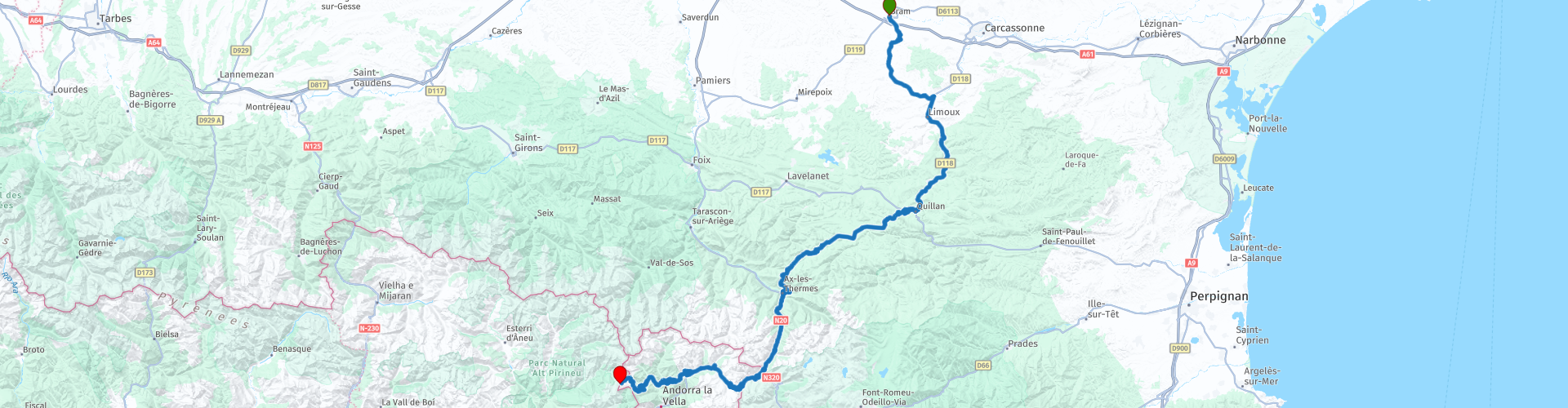
AUDE Bram to Andorra

This route was brought to you by:
RouteXpert Steve Montreal
Last edit: 11-02-2024
 Route Summary
 Along the way you will ride through valleys, along a high level plateau, over a 2400m mountain before finishing at the 2300m Port de Cabus in Andorra.
This route earns its 4* rating because of its thrilling mixture of spectacular scenery, thought provoking local history and some truly challenging riding roads.
This is another favourite of mine, no matter what the season.
There will be snow in winter, bright sunshine in summer & beautifully coloured landscapes in Spring and Autumn.
Ride Safe
 Share this route


Animation

Verdict


Duration
7h 57m

Mode of travel
Car or motorcycle

Distance
206.13 km

Countries


 RouteXpert Review
 Located on the eastern edge of the Lauragais in the Aude, the village of Bram has developed at the crossroads of two Roman roads: the Via Aquitania between Narbonne and Toulouse (the D33 follows its path), and a north-south road linking the Montagne Noire to the Ariège.
Its location was most certainly occupied as early as the 2nd century BC, according to the archaeological remains unearthed and the collections displayed at the Eburomagus Museum, Eburomagus being the original name of the village.
The ‘modern’ town is built in the circular style that was a typical of many built in the Languedoc during the 12th - 13th century.
There are 20+ other villages in the region built in this manner, known as ‘circulades’.
In 1210, at the beginning of the crusade against the Albigensians, the fortified village of Bram, was besieged by Simon de Montfort.
After a three-day siege, around 100 residents were taken as prisoners.
For good measure, the crusaders gouged their eyes & cut off their noses. Only one of them was spared an eye to lead an ominous procession to the Chateau de Lastours and announce the Crusaders arrival.
It's quite safe to walk the town these days, so take a wander around the old narrow streets, or explore the vibrant market that occurs each Wednesday.
In 1939 Bram was the site of a refugee camp housing Republican escapees from Spain at the end of the Spanish Civil War.
The roadside memorial now stands for the 224 refugees that perished in the camp.
They were first buried in a field at the end of the camp, but later they were transferred to the Montreal cemetery at the beginning of the 1950s.
The 12 hectare site, beside the railway line from Lavelanet, consisted of 170 wooden huts, each of 150 m2.
The first refugees from the coast were transported there by train, in convoys made up of men and children.
From May 1940, 1,300 women and more than 1,000 children were initially interned there, although up to 17,000 refugees lived there at one time.
The camp was surrounded by barbed wire more than two meters high with a watch tower at its centre.
This route later ends at the Smugglers Track in Andorra, which was also used by many fleeing Spanish refugees.
Later you will approach the town of Montreal, which is dominated by the Collegiale St.Vincent, which has more dark history from the time of the Albigensian Crusade.
In 1209, Montréal was taken and razed by Simon de Montfort´s troops.
The Lord of Lavaur and Montréal, was hanged, his sister was thrown into a well, 80 of his knights were executed and up to 400 Cathars were burned to death.
In 1273 the erection of the new castle started - and probably the church seen here was built in a "Tolosan-Gothic" style at the same time.
It was completed, using locally quarried pink marble, in 1318.
Recently the Collegiale has been subjected many phases of restoration, inside and out & is well worth a visit.
The impressive Puget pipe organ has recently undergone a €1.2 million restoration & is due to give its first public performance in May 2024.
Leaving Montreal you travel south east, through the vineyards & agriculture of the Malapere, towards Limoux.
Limoux is reputedly the home to the worlds oldest sparkling wine, Blanquette de Limoux, which was first created by Benedictine Monks in 1521 at the nearby St Hilaire Abbey.
Blanquette is made from locally grown Mausac grapes giving a distinct flavour.
Allegedly Dom Perignon visited the Abbey and worked with the monks. He later returned to Epernay, now the home of Champagne, taking the Blanquette ‘methode’ away with him to later create Champagne from Chardonnay grapes.
After Limoux, the route will follow the Aude River south to Quillan before climbing the Col de Portel hill climb course.
Each year, usually in May or June, this 5 km section of mountain road is used for a round of the French Hill Climb Championship.
Some seriously fast cars race up the challenging hill in fierce, high speed, competition. This twisting & challenging road is often included on the Tour de France route.
Ride it safely.
At the top of the hill climb you begin to travel along the high Plateau de Sault to the Col de Chiolua at 1449m, before descending into the spa town of Ax-les-Thermes.
Take time for a coffee beside the hot spring pool that is continuously filled by the hot mountain water that emerges nearby. Perhaps you may dangle your feet in its soothing waters.
Beware, it can be up to 70C at the back of the pool nearest the spring.
After coffee, you then join the main road south that follows the Ariege River until the long climb to the Province of Andorra and the town of Pas de la Casa.
Andorra is a tiny, independent principality situated between France and Spain in the Pyrenees mountains.
It is known for its ski resorts and tax-haven status that encourages duty-free shopping.
If shopping, make yourself aware of the duty free allowances, as regular checks are often carried out in both France and Spain.
Free motorcycle parking is available opposite the Daytona motorcycle clothing shop & there are many restaurants here in which to find a tasty lunchtime meal.
It is often advantageous to top up with petrol in Andorra as it is usually much cheaper.
Leaving Pas de la Casa, you will climb to the top of col at the 2408m Port de Envalira, for stunning views across the valleys.
Usually there is snow here from November to April, although the roads are normally kept clear.
On a recent visit we were sharing the large parking area with Skidoos!!
Descend the valley, avoiding the principality’s bustling main town of Andorra La Vella, by turning right at Canillo to visit the spectacular new viewpoint at Mirador del Quer.
Take the short walk to the 20-metre walkway & platform that is suspended in mid-air.
Part of the walkway is made of transparent glass & gives impressive views over the valleys of Montaup and Valira d’Orient.
The sculpture at the end of the walkway, ‘The Ponderer', by artist Miguel Ángel González, is sitting on a beam, undaunted, it appears as if the height causes him no fear whatsoever.
Later you pass through Ordino towards the final climb of the Col de Cabus.
The route ends, as does the tarmac, at the ‘Smugglers Track’ on the Port de Cabus at 2302m for more stunning views.
The Smugglers Route trail begins here and continues to Tor, a small village that lies on the border of Spain and Andorra, before ending in Ains on the Spanish side.
The Smugglers Route has been a safe corridor since the 20th Century, traversed by not only pilgrims, peddlars, and smugglers of contrabands, but by Spaniards fleeing the Spanish Civil War between 1936 and 1939 as well as WW2 refugees and evaders.
It is UNPAVED, but is still used by adventurous travellers on two wheels and four.
I have ridden it several times on an enduro bike, but I would advise caution if you intend to follow it on anything bigger.
If looking for accommodation in the area, I have used Hotel Coma, in Ordino which is a pleasant hotel which has secure garage parking for motorcycles.


 Links
Links  Usage
Usage Want to download this route?
You can download the route for free without MyRoute-app account. To do so, open the route and click 'save as'. Want to edit this route?
No problem, start by opening the route. Follow the tutorial and create your personal MyRoute-app account. After registration, your trial starts automatically.  Disclaimer
Use of this GPS route is at your own expense and risk. The route has been carefully composed and checked by a MyRoute-app accredited RouteXpert for use on TomTom, Garmin and MyRoute-app Navigation.
Changes may nevertheless have occurred due to changed circumstances, road diversions or seasonal closures. We therefore recommend checking each route before use.
Preferably use the route track in your navigation system. More information about the use of MyRoute-app can be found on the website under 'Community' or 'Academy'.

Occitanie
About this region
Occitanie (French pronunciation: [ɔksitani] (listen); Occitan: Occitània [utsiˈtanjɔ]; Catalan: Occitània [uksiˈtaniə]), Occitany or Occitania (), is the southernmost administrative region of metropolitan France excluding Corsica, created on 1 January 2016 from the former regions of Languedoc-Roussillon and Midi-Pyrénées. The Council of State approved Occitanie as the new name of the region on 28 September 2016, coming into effect on 30 September 2016.The modern administrative region is named after the larger cultural and historical region of Occitania, which corresponds with the southern third of France. The region Occitanie as it is today covers a territory similar to that ruled by the Counts of Toulouse in the 12th and 13th centuries. The banner of arms of the Counts of Toulouse, known colloquially as the Occitan cross, is used by the modern region and is also a popular cultural symbol. In 2015, Occitanie had a population of 5,839,867.
Read more on Wikipedia
View region
 Statistics
  71
71Amount of RX reviews (Occitanie)
 25940
25940Amount of visitors (Occitanie)
 3641
3641Amount of downloads (Occitanie)
 Route Collections in this region
 25 Magnificent trails in France
This MRA route collection contains 25 beautiful motorcycle routes in different parts of France, such as the Ardennes, the Alsace, Vercors, the Drôme, the Ardèche, Cote d'Azure, Gorges du Verdon, the Ariège, the Dordogne and Brittany.
The routes have been carefully created by Bert Loorbach, who is an enthusiastic motorcyclist himself. He lived in France for a year and a half, during which time he devoted himself to mapping the unknown and beautiful back roads of France especially for motorcyclists.
The routes are bundled in the Motortourgids France part 1 of Kosmos publishing house and now also available in MyRouteApp.
I have taken over the routes in MRA and sometimes adjusted them slightly to make them even more interesting for the motorcyclist.
View Route Collection
24 Magnificent trails in France
It is clear that France is one of the most beautiful and best touring countries. It offers an incredibly varied landscape with good roads and a pleasant climate. It is not for nothing that you see so many motorcyclists there. My previous collection of 25 routes in France (25 Magnificent routes in France) were based on the route descriptions from the Motortourgids France part 1 made by Bert Loorbach.
This collection of 24 routes comes from Motortourgids France part 2. In this collection, a difference has been made between approach routes and motorcycle tours in a certain area. The approach routes can also be used in combination with the routes from Motortourgids France part 1
The routes are sometimes slightly adjusted based on the tips that Bert Loorbach gives in his description, or because of another place to spend the night, or to reach the minimum length of 2 hours for the MRA Library. For each route, the review contains a more detailed description, including options to stay overnight or places of interest along the way, which are also indicated with a POI and if possible with a short description.
Two or more routes have been created for a number of areas, such as for Burgundy, Auvergne, The Alps, Tarn and Cévennes and Nord-Pas de Calais. These routes can be nicely combined in a multi-day trip.
View Route Collection