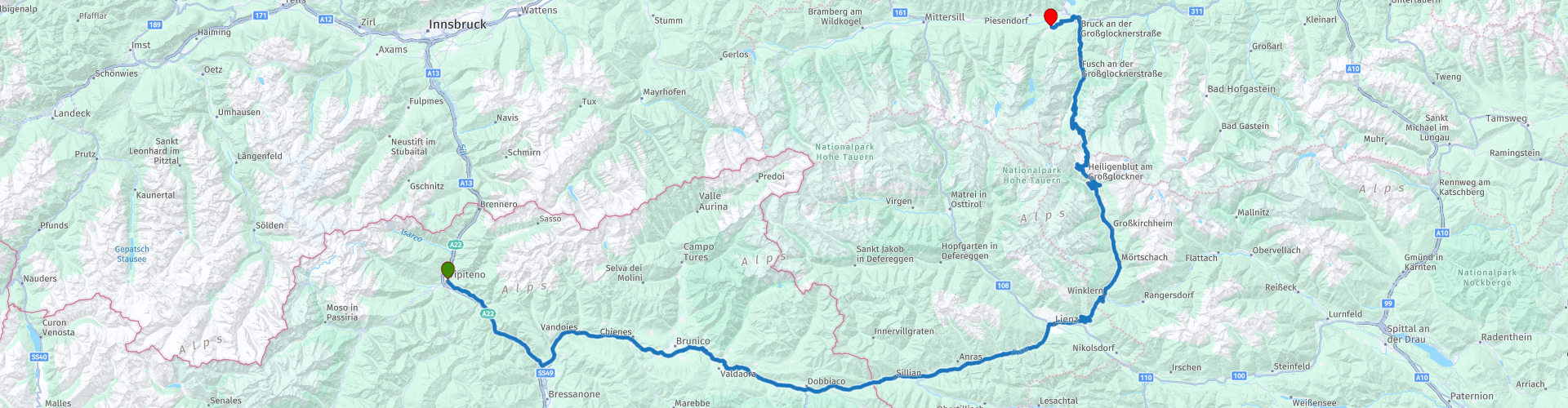
D5 Vipiteno Kaprun

This route was brought to you by:
RouteXpert Albert van den Elsen
Last edit: 27-10-2023
 Route Summary
 The route starts in the Texelgruppe Nature Park, in the north of Italy. The entire ride is a true paradise for nature lovers. You will find high mountains, lakes and forests. The route passes several nature reserves along the way, with the Hohe Tauern National Park as its highlight. So that promises something.
You continue your route east to Lienz and a coffee stop is planned just before the Austrian border.
The real adventure begins from Lienz. After one more stop you start your ride on the Großglockner High Alpine Road, an adventure along what is said to be the most beautiful road in Austria. The road takes you through the Hohe Tauern National Park, where you can enjoy breathtaking views of Austria's highest mountains. Just before the planned lunch stop, if the weather is good, you can enjoy a beautiful view of the Großglockner, the highest mountain in Austria. After a few hours of driving, after the lunch stop, you will arrive in Kaprun, a charming village in Salzburgerland. This is also the end point of this route.
Due to the many hairpin bends and beautiful views, this is another route in the 5 star category.
nb
The Großglockner High Alpine Road is open between May and November. Please note that tolls must be paid to pass through this street. In 2023, the tickets were €30 for a car and €23.50 for a motorcycle.
 Share this route


Animation

Verdict


Duration
6h 2m

Mode of travel
Car or motorcycle

Distance
218.66 km

Countries


 RouteXpert Review
 The adventure begins in the extensive Texelgruppe Nature Park, which covers no less than 33,430 hectares, making it the largest nature park in the region. This natural paradise is located between the Etschtal in the south, the picturesque Schnalstal in the west, the enchanting Passeiertal in the east, and the majestic main Alpine ridge in the north.
After a scenic drive of 8 kilometers, on the right side of the road, 'Schloss Welfenstein', also known as 'Castello Guelfo', appears near the town of Mules.
Although not a traditional castle, it is home to a leading wine cooperative that produces a rich variety of wines. As you drive past, the impressive sight of this building will enchant you and provide a glimpse into the wonderful world of wine production in this region.
If you continue along the road, you will reach the village of Franzensfeste, where you can enjoy a breathtaking view of the reservoir. This lake plays a crucial role in the generation of hydroelectric energy. A little further on you will pass the impressive Franzensfeste Fortress, named after Emperor Franz I of Austria. This fortress was built in the 19th century as part of the fortifications erected to protect the strategic Brenner Pass.
From here you continue your route via the Pustertalbahn along the river Rienz and you will encounter the Pustertaler autobahn tunnel, the first of many toll-free tunnels of the same name on this road.
A little further, just after Mühlbach, you can admire the Ruine Mühlbacher Klause on the left. This was once an important fortress with a strategic role along the trade route across the Alps, where tolls were collected and passage was guarded. Over the centuries, the structure has lost its military function and has been transformed into a picturesque ruin, now reminiscent of a bygone era.
The first mountain pass you encounter is the "Kniepass," also known as 'La Serra'. It is located at an altitude of 830 meters and serves as an essential connection between the Sarntal valley and the Passeiertal. This is a popular destination for tourists and locals alike, especially in the summer months. Shortly afterwards you reach Bruneck, where you encounter the second Pustertal Autobahn tunnel.
The next point of interest is the beautiful Olangersee, a mountain lake surrounded by the majestic Dolomites. You reach the lake just before you enter the next tunnel at Welsber. Near the town of Innichen you will later come across a military cemetery, where soldiers from both the First and Second World Wars found their final resting place. It is a solemn place worth paying tribute to.
As you approach the border with Austria, you will find 'Bar Café Pizzeria Tempele' on the left of the road. It is an ideal place to enjoy a cup of coffee before saying goodbye to Italy and entering Austria.
Once in Austria, you follow the Drau River and continue your journey along it, and slowly but surely more and more impressive mountain peaks appear on the horizon. Eventually you reach Lienz, a city that is more than worth a stopover for its historic city center. Once you've parked your vehicle, walk towards the famous Hauptplatz. Surrounded by historic buildings, this square is an attractive meeting place in the heart of the city, plays an important role in the social and commercial life of Lienz and is often the setting for events and markets, giving it a lively atmosphere. The beautiful architecture and views of the surrounding mountains make it an ideal place to soak up the atmosphere of the city and enjoy the unique charm of this historic place.
After exploring Lienz, set sail towards an iconic route, considered one of the most beautiful in all of Austria. While you pass many majestic mountain peaks, the Rossbach road transforms into the Großglockner High Alpine Road. From this point you will be taken along 48km and 36 hairpin bends along this legendary route to the highest point of this road, revealing the breathtaking panorama of the Hohe Tauern mountain range. First the road takes you to the Hochtor Pass.
At this pass, at a height that seems to defy the limits of imagination, you will stop to enjoy the impressive view that stretches out before you. Let your camera click as you try to capture the overwhelming beauty. Here, in this enchanting place, the boundaries between dream and reality disappear.
After your moment of wonder, drive fearlessly into the tunnel that serves as a connection between the picturesque province of Styria and the highly acclaimed Carinthia. On either side of this tunnel tube is the text 'in te domini speravi', which no longer means 'I hoped in You, O Lord'. A meaning like 'thank you that a long-awaited wish for the construction of the tunnel has become reality'.
As you leave, you embrace not only a new landscape but also the continued promise of adventure and discovery on this epic journey through the Austrian Alps and all its mountain ranges.
Finally, you reach the highlight of this unforgettable route, the Fusher Törl viewpoint and the adjacent restaurant of the same name, where you can enjoy a delicious lunch.
In particular, the 'Fusher Törl' viewpoint offers you a breathtaking view of the Hohe Tauern National Park, where the most enchanting mountain peaks stretch out before you.
From the restaurant you can enjoy a panoramic view of the enchanting winding roads that extend both left and right of this location. If you are going to enjoy lunch, from personal experience I can highly recommend the local Goulash soup. That one is really delicious. But in addition to time for lunch, also take some time to enjoy this special panoramic place and do not hesitate to take countless photos, because the beauty of this area deserves to be remembered forever.
Immediately after your lunch you will arrive at the Eberhard Stüber Research Station or "The Eberhard Stüber Research Station for High Alpine Studies". Scientists and researchers here conduct research in various fields, such as ecology, geology, climate science, biology and other disciplines relevant to high alpine environments. Take some time to visit the research center here and view the surroundings.
After braving a series of challenging hairpin bends, enjoying the beautiful views of the surrounding mountains, you reach Ferleiten, where you arrive at the toll gate of the Großglockner High Alpine Road. Here you will have the opportunity to pay the toll for using this beautiful road, which contributes to the preservation of this natural wonder. But that is not the only highlight that Ferleiten has to offer.
At this location you can also visit the adjacent Ferleiten Wild Park. In this park you can admire a range of native animals, including deer, chamois, mouflons, lynx, and much more. What makes Wildpark Ferleiten really special is the opportunity to observe these animals in their natural habitat, directly from the strategically located viewing points.
It is a great opportunity to get closer to nature and experience the beauty and diversity of native wildlife while enjoying the beautiful landscape that surrounds the Großglockner High Alpine Road.
When leaving Ferleiten, the last stage to the final destination of this unforgettable route begins. With 30 kilometers to go, you can look back on a day full of special and impressive experiences. It was a day full of highlights, and the many hairpin bends that transformed you into a true expert in navigating these mountain areas.
Just before your arrival in Kaprun, you will make a quick fuel stop. Looking back on the day, enjoying a refreshing drink and delicious food, you realize that this adventure has been an unforgettable experience. It was a day that will certainly hold a place in your heart.


 Links
Links  Usage
Usage Want to download this route?
You can download the route for free without MyRoute-app account. To do so, open the route and click 'save as'. Want to edit this route?
No problem, start by opening the route. Follow the tutorial and create your personal MyRoute-app account. After registration, your trial starts automatically.  Disclaimer
Use of this GPS route is at your own expense and risk. The route has been carefully composed and checked by a MyRoute-app accredited RouteXpert for use on TomTom, Garmin and MyRoute-app Navigation.
Changes may nevertheless have occurred due to changed circumstances, road diversions or seasonal closures. We therefore recommend checking each route before use.
Preferably use the route track in your navigation system. More information about the use of MyRoute-app can be found on the website under 'Community' or 'Academy'.

Carinthia
About this region
Carinthia (German: Kärnten [ˈkɛʁntn̩] (listen); Slovene: Koroška [kɔˈɾóːʃka] (listen)) is the southernmost Austrian state or Land. Situated within the Eastern Alps, it is noted for its mountains and lakes. The main language is German. Its regional dialects belong to the Southern Bavarian group. Carinthian Slovene dialects, forms of a South Slavic language that predominated in the southeastern part of the region up to the first half of the 20th century, are now spoken by a small minority in the area.
Carinthia's main industries are tourism, electronics, engineering, forestry, and agriculture. The multinational corporations Philips, Infineon Technologies and Siemens have large operations there.
Read more on Wikipedia
Carinthia's main industries are tourism, electronics, engineering, forestry, and agriculture. The multinational corporations Philips, Infineon Technologies and Siemens have large operations there.
View region
 Statistics
  35
35Amount of RX reviews (Carinthia)
 35247
35247Amount of visitors (Carinthia)
 4801
4801Amount of downloads (Carinthia)
 Route Collections in this region
 The 24 Most Beautiful Alpine Routes
The Alps, The Alps are a mountain range in Europe, stretching from the French Mediterranean coast in the southwest to the Pannonian Plain in the east. The area of the mountain range is more than 200,000 km².
In other words Passes and Mountain Roads!
Driving through the mountains is great! Especially over the mountain passes with hairpin bends and narrow winding roads. Every bend a different view where you can enjoy. There are many beautiful mountain passes in the Alps.
A selection that has also been incorporated into these routes:
The Stlevio Pass:
The Stelvio Pass, also known as Passo dello Stelvio, is mainly known for the stage in the Giro d'Italia. Due to the length and the difference in height, this pass is seen as one of the toughest tests in cycling. The Stelvio Pass reaches a maximum height of 2758 meters and is therefore one of the highest in the Alps. The pass connects the towns of Bormio and Prato Allo Stelvio. In winter the pass is closed due to heavy snowfall.
The Reschenpass:
The Reschenpass, also known as Passo di Resia, connects the Austrian state of Tyrol with the Italian province of South Tyrol. The pass reaches a maximum height of 1,504 meters and has been one of the most important north-south connections in the Alps in recent centuries. The pass was used long before Roman times. Along the way you will pass several highlights and historical relics. One of the highlights is the Reschensee. This lake was created after the construction of the dam and has completely submerged the village of Graun. The only thing that reminds of that is the clock tower in the middle of the lake.
Col du Galibier:
The French mountain pass Col du Galibier connects the towns of Saint-Michel-de-Maurienne and Briançon via the Col du Lautaret in the south and the Col du Télégraphe in the north. The mountain pass is part of the Tour de France and very much feared, due to the fact that it can only be reached via the other two mountain passes. The pass reaches a maximum height of 2646 meters. From there you can take a walk to the viewpoint at 2704 meters. You can admire the peaks of the Grand Galibier, Mont Blanc and La Meije here.
The Grossglockner High Alpine Road:
With a height of 3798 meters the Grossglockner is the highest mountain in Austria. To fully enjoy this impressive mountain, you can drive over the Grossglockner High Alpine Road and the accompanying pass. The route starts from Bruck am Grossglockner and ends in Heiligenblut. Of course you can drive in two directions. The pass reaches a maximum height of 2504 meters and is closed in winter due to heavy snowfall. Along the way you pass several stops with fun activities, information points, mountain huts and viewpoints. A visit to the Kaiser-Franz-Josefs-Höhe and Pasterzen Glacier is highly recommended.
The Col d'Izoard:
Just like the Col du Galibier, the Col d'Izoard is also part of a stage of the Tour de France. The mountain pass connects Briançon with the valley of the river Guil. The pass is partly located in the Regional Natural Park du Queyras and reaches a maximum height of 2360 meters. What is special about the Col d'Izoard is the barren and rocky landscape. Sometimes it feels like driving a car over the moon! Along the way you can stop at several points to enjoy the beautiful view.
The Bernina Pass:
The Bernina Express is one of the most famous rail trains in Switzerland and the Alps. The route is beautiful and partly included on the UNESCO World Heritage List. Parallel to the railway lies the Bernina pass, which connects the Veltlin valley with the Egandin valley. This beautiful Alpine road has a total length of 56 kilometers and reaches a maximum height of 2328 meters. Along the way you can enjoy views of the Morteratsch Glacier.
The Sella Pass:
The Sella Pass, also known as Passo di Sella, takes you over one of the most impressive mountain ranges in the Dolomites: the Sella massif. The pass connects Valle di Fassa with Val Gardena and reaches a maximum height of 2236 meters. At this height is also the border of the Italian provinces of Trentino and Bolzano. Along the way you can enjoy the view of this spectacular mountain world. Admire, for example, the three peaks of the Sasso Lungo massif, the Sella massif or the peaks of the Marmolada. You can also drive the Sella pass in combination with the Gardena pass, Pordoi pass and Campolongo pass.
The Grimsel Pass:
The Grimsel Pass connects Goms in Wallis with the Halis Valley in the Bernese Oberland. The pass reaches a maximum elevation of 2165 meters and is closed in winter due to snowfall. Over the centuries, the mountain pass has played an important role in trade between Switzerland and Italy. Now it is mainly the reservoirs that have an important function. These are used to generate electricity. The landscape you drive through is rugged, rocky and impressive. On top of the pass is a hotel and a restaurant with a special marmot park. The Dodensee (Totensee) is also located here. This lake owes its name to the many soldiers who died in the time of Napoleon.
The Gotthard Pass:
The Gotthard Pass, also known as Passo del San Gottardo and Saint Gotthard, connects the Swiss towns of Airolo and Andermatt. The mountain pass and associated tunnel are especially known among holidaymakers driving from Switzerland to Italy. But where the majority opt for the tunnel, it is precisely the pass that really completes the holiday. The Gotthard Pass has a length of about 26 kilometers and reaches a maximum height of 2106 meters. The route is beautiful and takes you along old villages and beautiful views.
The Silvretta High Alpine Road and Silvretta Pass:
The Paznaun Valley in Tyrol and the Montafon in Vorarlberg are connected by the Silvretta High Alpine Road. The route has a length of 22.3 kilometers and leads from Galtür to Partenen in 34 hairpin bends, via the 2032 meter high Bielerhöhe. The Silvrettasee is also located at this point, where you can enjoy a lovely walk. The pass is closed in winter due to snowfall.
The Simplon Pass:
Just like the Gotthard Pass, many holidaymakers also travel over the Simplon Pass every year. This mountain pass connects the Rhone Valley in the canton of Valais with the Valle d'Ossola in Piemonte. The pass is open all year round and reaches a maximum height of 2005 meters. Along the way you pass a number of buildings, including the well-known Simplon Hospiz from 1825. The hospiz is managed by the monks of St. Bernard. From the highest point on the pass, all kinds of hiking routes are possible and you will also come across a hotel where you can spend the night.
The Gerlos Pass:
The Gerlos Pass connects the Salzach Valley in the Salzburgerland with the Zillertal Valley in Tyrol. The pass is part of the Gerlos Alpenstraße and runs right through the Hohe Tauern National Park. Along the way you can enjoy beautiful views of the surroundings. The pass has a length of 12 kilometers and reaches a maximum height of 1531 meters. A ride over the Gerlos Pass can be ideally combined with a visit to the Krimmler Wasserfälle.
The Great St. Bernard Pass:
The Great St. Bernard Pass, better known as Col du Grand Saint Bernard, connects the Italian province of Valle d'Aosta with the Swiss canton of Valais. The pass is one of the highest in Switzerland and reaches a maximum height of 2469 meters. Like a number of other mountain passes in this list, the Great St. Bernard Pass has also been used as a connecting road for centuries. The pass is named after the St. Bernard dogs that used to help stranded travelers along with the monks. The pass is closed in winter.
The Timmelsjoch High Alpine Road:
The Timmelsjoch High Alpine Road connects the towns of Sölden in the Ötztal and Meran in South Tyrol. Tolls must be paid on the Hochgurgl - Moos route. Via a mountain road with about 60 hairpin bends you drive through a beautiful mountain world. With the Timmelsjoch Experience you can learn more about the history, the road and the environment via various stations. You can also visit the Top Mountain Crosspoint museum.
Col de l'Iseran:
With a maximum pass height of 2770 meters, the Col l'Iséran is one of the highest mountain passes in the Alps. The pass connects Bourg-Saint-Maurice with Bonneval-sur-Arc. Via a road full of hairpin bends you pass, among other things, Val-d'Isère and a side valley of the Maurienne that lies entirely in the National Park de la Vanoise. You can spot animals such as marmots and chamois and there is also a restaurant with a chapel on top of the pass.
The Gavia Pass:
The Gavia Pass (Italian Passo di Gavia) is a mountain pass in the Italian Alps, in the Lombardy region.
It is one of the highest pass roads in Europe. The road leads through the unspoilt Stelvio National Park. The road was built in the First World War to supply Italian soldiers who fought in the Italian-Austrian border area. The pass height is one of the most beautiful in the Alps. Here is the large Lago Bianco with, to the north, the mountain San Matteo (3684 meters). Lago Nero is slightly lower on the south side of the pass. Here the mountain group of the Adamello determines the view. There are many well-marked walks in the area. During the winter the pass is closed due to the heavy snowfall. The pass is often closed until May and June due to the large amount of snow.
Promoter has made a selection of the 24 Most Beautiful Alpine routes that they have set out in recent years.
The routes go through:
France
Austria
Switzerland
Italy
The most beautiful roads, the most beautiful views, the most beautiful viewpoints. The highest mountains, the fastest descents, hairpin bend after hairpin bend, you name it you can't get enough of it.
If you go on holiday in this region, take advantage of it, ALL routes in this collection have been checked and made equal for TomTom, Garmin and MyRoute-app Navigation by a MyRoute-app RouteXpert.
Have fun with this collection and while driving one of these routes. Enjoy all the beauty that the Alps and the Dolomites have to offer. Click on “View route” to read the review of the chosen route.
I would like to hear your findings about the route(s).
View Route Collection
The 12 most beautiful car and motorcycle routes in Carinthia
“Motorradland Kärnten” where you feel so wonderfully welcome as a motorcyclist!
Own website for motorcyclists, own curated routes, hotels, campsites and guest houses with attention for motorcyclists, a wonderful area where motorcyclists are very popular.
Kärnten or Carinthia, at the crossroads of the Germanic, Slavic and Roman worlds. Three cultures within a few kilometres, southern flair, culinary delights, cross-border tours. Breakfast in Italy, lunch in Slovenia, dinner in Austria - all in one day. Experience the diversity in the borderless Alps-Adriatic region, the area for motorcyclists.
Extensive day trips on winding mountain paths, romantic panoramic routes and beautiful lakes, here the 12 TOP routes Kärnten / Carinthia. Enjoy!
View Route Collection