R07 Castello Molina di Fiemme to Reutte

This route was brought to you by:
RouteXpert Arno van Lochem - Senior RX
Last edit: 23-09-2022
 Route Summary
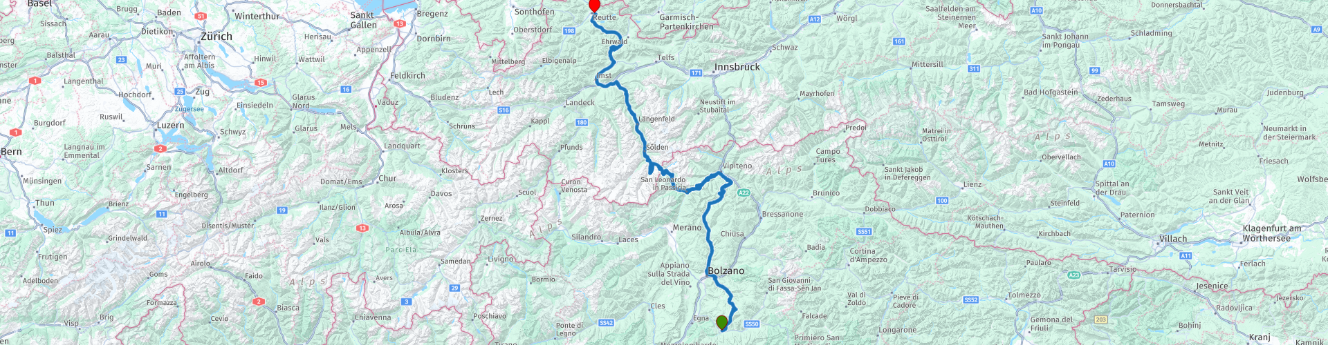
 In this route you actually start the (long) journey back home. Don't worry, there is still a lot of beautiful things on the program today. How about the almost 2500 meters high Timmelsjoch? In addition, if you feel like it, you can visit the highest point of this 10-day tour. You then turn right before Solden to the Ötztaler Gletscherstraße and climb to an altitude of 2829 meters. Note: The last 8 kilometers toll must be paid (see links for prices)
There are a number of beautiful viewpoints marked along the way, but there are so many more. You also pass a number of sights on the Timmelsjoch, perhaps nice to stop for a while.
Because of the beautiful passes, the great roads and all the beauty that can be seen along the way, this route deserves 5 stars.
Given the distances in mountainous areas and the many hairpin bends that can be very narrow at times, this route is suitable for the more advanced motorcyclist.
 Share this route


Animation

Verdict


Duration
9h 11m

Mode of travel
Car or motorcycle

Distance
289.02 km

Countries


 RouteXpert Review
 You leave the hotel via the same road you came in. Shortly after the start you have the opportunity to fill the tank again if necessary. The first few kilometers you will head for Cavaleze, where you will begin the ascent of the first pass in this route: The Lavazèpass. The Lavazè Pass (Italian: Passo di Lavazè) is located on the border of the Italian provinces of Trento and South Tyrol. It is also the Italian-German language border. The Lavazè Pass is open all year round.
From the south, the road starts in Cavalese, which is located in the Valle di Fiemme. The place made headlines in 1998 when a fighter jet flew through the cables of a mountain railway, causing 20 casualties. A good road goes up through Varena through thick forests to the top. On the way, a road branches off to the right to the 1431 meter high Passo di Pramadiccio (driven in R06) which leads to Stava. The last kilometers before the pass height have a significantly higher gradient (up to 12%). From the pass height one has a view of the mountain group of the Latemar. To the west a road leads to another pass: the Grimmjoch. The descent goes through the Selva di Ega (Eggenwald) down to Ponte Nova in the Eggental. Along the way, there are occasional views of the Rosengarten massif.
After driving through two tunnels you will enter Bolzano. First a piece of industrial estate, later through a part of the center. It is not a punishment to drive through this city, there is plenty to see. The fairly narrow streets occasionally reflect the (busy) Italian life.
You will soon be out again and you will be driving between the green mountain slopes and meadows again. You're heading for the Penser Joch. This pass (Italian: Passo di Pénnes) is a mountain pass in the Italian South Tyrol. The 2211 meter high pass connects the Sarntal north of the provincial capital Bozen (Bolzano) and the Wipptal near Sterzing (Vipiteno). As the crow flies, the route over the Penser Joch is the shortest connection between Bozen and Innsbruck in Austria. The current road was completed in 1938, with the construction of the section between the top and Sterzing.
The pass height can be reached from both the north and the south via a well-maintained road. Near the top, however, it is occasionally narrower and curvier. From the Penser Joch you have a good view of the Zillertal Alps. Along the way great green panoramic views where the road meanders wonderfully in between. The ascent of the Penser Joch is a very quiet, very gradual climb to the top, where it is high time for a cup of coffee.
The Penser Joch's descent is one to remember. With the right speed you can whiz through the many bends. Far too soon you arrive in the valley at Sterzing-Vipiteno. There you turn left to visit the next pass, the Giovopass. This is a mountain pass in the Italian South Tyrol. The 2099 meter high pass connects the Passeiertal at Sankt Leonhard in Passeier with the Wipptal at Sterzing, close to the Brenner Pass. The winding road has twenty hairpin bends and a total length of 39 km.
To the north of the pass road are the high peaks of the Ötztal Alps, to the south those of the Sarntal Alps. Around the pass are the peaks of the Jaufenspitz (2483 meters) and the Saxner (2359 meters) and the wide Ratschingstal.
Almost at the end of the wonderful descent over perfect asphalt you pass a viewpoint which gives a great view over the Passiria Valley. Good place to stop for a while and feast your eyes.
After San Leonardo in Passiria the ascent of the Timmelsjoch begins. Soon you will arrive in Moso in Passiria where you will again find a viewpoint called Garnetshebt with a beautiful view. Standing on the rocky hill near Stuls, a beautiful view opens up to the village of Moos and over the far end of the Passeiertal valley. Two shells, modeled after the geological rock formations in the Passeiertal, serve as an exhibition space and viewing platform. Again worth a stop. And then the long ascent of the Timmelsjoch begins...
The Timmelsjoch (Italian: Passo del Rombo) is a 2,509 meter high mountain pass on the border between Austrian Tyrol and Italian South Tyrol. The pass connects Sölden in the Ötztal with St. Leonhard in Passeier in the Passeiertal towards Meran. The Timmelsjoch separates the Ötztal Alps from the Stubai Alps and is located between two mountain peaks, the Jochköpfl (3141 m) in the northeast and the Wurmkogl (3082 m) in the southwest. The pass is much less important for traffic than the Reschen Pass (40 kilometers to the west) or the Brenner Pass (25 kilometers to the east). The name Timmels probably comes from the Latin tumulus, which means hill.
In prehistoric times from the south, the first inhabitants moved from the Passeiertal via the Timmelsjoch to the Ötztal. As early as 1241 the pass was mentioned as Thymels. Around 1320 a steep mountain path for pack mules was built. It formed an early trading route for the merchant families Fugger and Welser from Augsburg. In 1897 the Tyrolean Landdag decided to build a road over the Timmelsjoch, but other projects were given priority.
The 1919 Treaty of Saint-Germain crossed the pass between Austria and Italy. In the last weeks of the Second World War in April and May 1945, large numbers of Wehrmacht soldiers retreated to the Ötztal.
Shortly after the Second World War, the plan was put on the table to build a road over the Timmelsjoch. Austrian politician Eduard Wallnöfer took the lead. Between 1955 and 1959 the road was built on the north side for a total construction cost of 28 million schillings (approximately 2 million euros). The southern part from the Passeiertal to two kilometers below the pass had already been built during the reign of Benito Mussolini from 1933. However, upon the conclusion of the Axis alliance in 1936, Mussolini and Adolf Hitler agreed to cease operations. On July 7, 1959, the entire road was built, but it was not until September 15, 1968 before the road was opened in both directions.
The Timmelsjoch is normally accessible from mid-June to mid-October, between 07:00 and 20:00. Due to the high gradients, the road is off limits for freight traffic and is a popular trip by car or motorcycle for many tourists. The Ötztal bicycle marathon takes place every year over the Timmelsjoch and in 1988 the Giro d'Italia also crossed the pass. Timmelsjoch is Austria's highest border crossing. A toll is charged at the village of Hochgurgl. Part of the toll is paid to South Tyrol. The region has also become known for the discovery of Ötzi, the name given to the ice mummy of a man from the Copper Age. Two German amateur mountaineers found him on September 19, 1991 in the Italian Ötztal Alps, Timmelsjoch area.
Along the way on the Timmelsjoch there are a number of places of interest: The (already mentioned) Garnets, Telescope, Transit, Passmuseum, Walkway and Smuggler. All interesting places to take a look:
- Motorcycle Museum. The highest motor museum in Europe is also located at the toll gate. Recently completely burned down, but they managed to rebuild it in no time. The architecture of the museum is already very remarkable, but the combination with the exhibits makes it a must-see - even if you're not a motorcyclist. On 3,000 m², about 230 classic motorcycles from about 100 manufacturers are presented along with some automotive rarities.
- Garnets: Standing on the rocky hill near Stuls, a beautiful view opens up towards the village of Moos and over the extremity of the Passeiertal valley. Two shells, modeled after the geological rock formations in the Passeiertal, serve as an exhibition space and viewing platform.
- Telescope: The vast area below the Scheibkopf mountain offers a beautiful 180° panorama over the Texelgruppe nature reserve. A telescope draws the viewer's attention to the Granatkogel (3,304 m) and the Hohe First (3,403 m), which stand out clearly from the eternal glacial ice.
- Transit: An old military barracks from the 1930s has been converted into a special museum space.
There are unpublished images of the road construction and authentic contemporary witness interviews of people from the Passeier and the Ötztal. The exhibition is intended to commemorate the road builders.
- Passmuseum: The new Passmuseum on the North Tyrolean side protrudes like a jagged boulder into the South Tyrolean side and underlines the cross-border character of the Timmelsjoch Experience. The "Ice Cave" in the museum is a tribute to the pioneers of the High Alpine Road and their remarkable achievement.
- An unparalleled panorama opens up at the site of the toll booth in Hochgurgl, offering sweeping views over the far end of the Ötztal valley and the awe-inspiring rise of 3000m peaks. An innovative walkway, which offers a totally new and breathtaking perspective, provides in-depth information about the area and its distinctive features.
- Smuggler: A walk-in cube is created where the Timmelsjochweg crosses the ancient path from Zwieselstein to Moos im Passeier. It takes you to a world of adventure and danger, the world of the smugglers and their ancient route across the Timmelsjoch.
By now you are driving in Austria and you are heading towards Sölden, known to many as the ski resort. In Sölden you have the opportunity to visit the highest asphalted point in Austria. The Ötztal Gletscherstraße is an Austrian road in the state of Tyrol. The road starts in Sölden in the Ötztal, where the road branches off from the main road through this valley, the Ötztalstraße (B186).
The road leads to the Ötztal glaciers Rettenbachferner and Tiefenbachferner. The part of the road leading to the Tiefenbachferner runs through the highest tunnel in Europe. At the end of this tunnel, the road reaches the highest tarmac point in Austria at an altitude of 2829 metres. This road is open to motorized traffic in the summer months (passenger cars and motorcycles; caravans and trailers not allowed).
A toll has to be paid for the last 8 kilometers to the top (see link for prices). Of course these are the most beautiful kilometers of the Gletscherstraße, that should be clear. But you do get something in return. Excellent asphalt and great views over the glacier. They do their utmost not to let the thing melt too much, but if that will work.... I sincerely hope so!
After Sölden you continue to the north through Tyrol and after about 60 kilometers you get a view of the last pass of this route, the Fernpass. The Fern Pass is a 1,212 meter high mountain pass in the Austrian state of Tyrol. The pass provides a fast connection between Imst in the Inn Valley and Reutte in northern Tyrol. Garmisch-Partenkirchen is also quickly accessible from the west of the Oberinntal via this pass. The Fern Pass is located between the Lechtaler Alps in the west and the Mieminger Mountains in the east. The Zugspitze is located 13.5 km northeast of the pass in the Wetterstein Mountains. The pass height, which is located slightly south-west of Ehrwald, lies between the Grubigstein (2233 m), the Wannig (2493 m) and the Loreakopf (2471 m).
The pass was created about 4100 years ago by a large landslide, which filled the valleys between the mountains. The Fern Pass leads over this mountain ridge, past a number of lakes, of which the Blindmeer is the largest. Over the Fern Pass lies the busy Austrian B179, which connects Reutte via the Lermooser Tunnel with Nassereith and Tarrenz or Imst. The connecting roads connect Garmisch-Partenkirchen (Germany), Mieming and Telfs. This makes the pass one of the most traveled passes in the Eastern Alps. The maximum gradient is 8%, the height difference to be overcome is 371 meters.
The Fern Pass has been known as a mountain pass for many centuries. The Via Claudia Augusta ran over the Fern Pass in Roman times, which was the main route between Germania and northern Italy.
The pre-Roman trade in amber is said to have already passed through the Fern Pass. Archaeological finds have been made along the many roads leading to the pass, showing the significance of the Fern Pass for trade between the Baltic Sea and northern Italy and even Greece. The Fernpass is the second alpine pass on the old Reschenroute, built by the Romans. The Romans expanded the existing road in the years 46/47 AD and the road remained in use until the late Middle Ages. The road was named after its designer, Emperor Claudius. The Via Claudia Augusta. Later it was also called High Street, in contrast to the Lower Street, the nickname of the Brenner route. For a long time, the road was the most important German-Italian alpine connection, due to the relative security against winter and flooding and the fact that there were virtually no steep, dangerous road sections.
After this last pass in the route, it is still a short distance in the direction of Reutte, where the end point, Alpenhotel Ernberg, can be found. This is a hotel with a rural feel where they serve a good meal (both breakfast and dinner) and a good pot of beer, all for a reasonable price. Recommended!
Have fun driving this route!


 Links
Links  Usage
Usage Want to download this route?
You can download the route for free without MyRoute-app account. To do so, open the route and click 'save as'. Want to edit this route?
No problem, start by opening the route. Follow the tutorial and create your personal MyRoute-app account. After registration, your trial starts automatically.  Disclaimer
Use of this GPS route is at your own expense and risk. The route has been carefully composed and checked by a MyRoute-app accredited RouteXpert for use on TomTom, Garmin and MyRoute-app Navigation.
Changes may nevertheless have occurred due to changed circumstances, road diversions or seasonal closures. We therefore recommend checking each route before use.
Preferably use the route track in your navigation system. More information about the use of MyRoute-app can be found on the website under 'Community' or 'Academy'.

Tyrol
About this region
Tyrol (; German: Tirol [tiˈʁoːl] (listen); Italian: Tirolo) is a state (Land) in western Austria. It comprises the Austrian part of the historical Princely County of Tyrol. It is a constituent part of the present-day Euroregion Tyrol–South Tyrol–Trentino (together with South Tyrol and Trentino in Italy). The capital of Tyrol is Innsbruck.
Read more on Wikipedia
View region
 Statistics
  35
35Amount of RX reviews (Tyrol)
 44633
44633Amount of visitors (Tyrol)
 5496
5496Amount of downloads (Tyrol)
 Route Collections in this region
 The 24 Most Beautiful Alpine Routes
The Alps, The Alps are a mountain range in Europe, stretching from the French Mediterranean coast in the southwest to the Pannonian Plain in the east. The area of the mountain range is more than 200,000 km².
In other words Passes and Mountain Roads!
Driving through the mountains is great! Especially over the mountain passes with hairpin bends and narrow winding roads. Every bend a different view where you can enjoy. There are many beautiful mountain passes in the Alps.
A selection that has also been incorporated into these routes:
The Stlevio Pass:
The Stelvio Pass, also known as Passo dello Stelvio, is mainly known for the stage in the Giro d'Italia. Due to the length and the difference in height, this pass is seen as one of the toughest tests in cycling. The Stelvio Pass reaches a maximum height of 2758 meters and is therefore one of the highest in the Alps. The pass connects the towns of Bormio and Prato Allo Stelvio. In winter the pass is closed due to heavy snowfall.
The Reschenpass:
The Reschenpass, also known as Passo di Resia, connects the Austrian state of Tyrol with the Italian province of South Tyrol. The pass reaches a maximum height of 1,504 meters and has been one of the most important north-south connections in the Alps in recent centuries. The pass was used long before Roman times. Along the way you will pass several highlights and historical relics. One of the highlights is the Reschensee. This lake was created after the construction of the dam and has completely submerged the village of Graun. The only thing that reminds of that is the clock tower in the middle of the lake.
Col du Galibier:
The French mountain pass Col du Galibier connects the towns of Saint-Michel-de-Maurienne and Briançon via the Col du Lautaret in the south and the Col du Télégraphe in the north. The mountain pass is part of the Tour de France and very much feared, due to the fact that it can only be reached via the other two mountain passes. The pass reaches a maximum height of 2646 meters. From there you can take a walk to the viewpoint at 2704 meters. You can admire the peaks of the Grand Galibier, Mont Blanc and La Meije here.
The Grossglockner High Alpine Road:
With a height of 3798 meters the Grossglockner is the highest mountain in Austria. To fully enjoy this impressive mountain, you can drive over the Grossglockner High Alpine Road and the accompanying pass. The route starts from Bruck am Grossglockner and ends in Heiligenblut. Of course you can drive in two directions. The pass reaches a maximum height of 2504 meters and is closed in winter due to heavy snowfall. Along the way you pass several stops with fun activities, information points, mountain huts and viewpoints. A visit to the Kaiser-Franz-Josefs-Höhe and Pasterzen Glacier is highly recommended.
The Col d'Izoard:
Just like the Col du Galibier, the Col d'Izoard is also part of a stage of the Tour de France. The mountain pass connects Briançon with the valley of the river Guil. The pass is partly located in the Regional Natural Park du Queyras and reaches a maximum height of 2360 meters. What is special about the Col d'Izoard is the barren and rocky landscape. Sometimes it feels like driving a car over the moon! Along the way you can stop at several points to enjoy the beautiful view.
The Bernina Pass:
The Bernina Express is one of the most famous rail trains in Switzerland and the Alps. The route is beautiful and partly included on the UNESCO World Heritage List. Parallel to the railway lies the Bernina pass, which connects the Veltlin valley with the Egandin valley. This beautiful Alpine road has a total length of 56 kilometers and reaches a maximum height of 2328 meters. Along the way you can enjoy views of the Morteratsch Glacier.
The Sella Pass:
The Sella Pass, also known as Passo di Sella, takes you over one of the most impressive mountain ranges in the Dolomites: the Sella massif. The pass connects Valle di Fassa with Val Gardena and reaches a maximum height of 2236 meters. At this height is also the border of the Italian provinces of Trentino and Bolzano. Along the way you can enjoy the view of this spectacular mountain world. Admire, for example, the three peaks of the Sasso Lungo massif, the Sella massif or the peaks of the Marmolada. You can also drive the Sella pass in combination with the Gardena pass, Pordoi pass and Campolongo pass.
The Grimsel Pass:
The Grimsel Pass connects Goms in Wallis with the Halis Valley in the Bernese Oberland. The pass reaches a maximum elevation of 2165 meters and is closed in winter due to snowfall. Over the centuries, the mountain pass has played an important role in trade between Switzerland and Italy. Now it is mainly the reservoirs that have an important function. These are used to generate electricity. The landscape you drive through is rugged, rocky and impressive. On top of the pass is a hotel and a restaurant with a special marmot park. The Dodensee (Totensee) is also located here. This lake owes its name to the many soldiers who died in the time of Napoleon.
The Gotthard Pass:
The Gotthard Pass, also known as Passo del San Gottardo and Saint Gotthard, connects the Swiss towns of Airolo and Andermatt. The mountain pass and associated tunnel are especially known among holidaymakers driving from Switzerland to Italy. But where the majority opt for the tunnel, it is precisely the pass that really completes the holiday. The Gotthard Pass has a length of about 26 kilometers and reaches a maximum height of 2106 meters. The route is beautiful and takes you along old villages and beautiful views.
The Silvretta High Alpine Road and Silvretta Pass:
The Paznaun Valley in Tyrol and the Montafon in Vorarlberg are connected by the Silvretta High Alpine Road. The route has a length of 22.3 kilometers and leads from Galtür to Partenen in 34 hairpin bends, via the 2032 meter high Bielerhöhe. The Silvrettasee is also located at this point, where you can enjoy a lovely walk. The pass is closed in winter due to snowfall.
The Simplon Pass:
Just like the Gotthard Pass, many holidaymakers also travel over the Simplon Pass every year. This mountain pass connects the Rhone Valley in the canton of Valais with the Valle d'Ossola in Piemonte. The pass is open all year round and reaches a maximum height of 2005 meters. Along the way you pass a number of buildings, including the well-known Simplon Hospiz from 1825. The hospiz is managed by the monks of St. Bernard. From the highest point on the pass, all kinds of hiking routes are possible and you will also come across a hotel where you can spend the night.
The Gerlos Pass:
The Gerlos Pass connects the Salzach Valley in the Salzburgerland with the Zillertal Valley in Tyrol. The pass is part of the Gerlos Alpenstraße and runs right through the Hohe Tauern National Park. Along the way you can enjoy beautiful views of the surroundings. The pass has a length of 12 kilometers and reaches a maximum height of 1531 meters. A ride over the Gerlos Pass can be ideally combined with a visit to the Krimmler Wasserfälle.
The Great St. Bernard Pass:
The Great St. Bernard Pass, better known as Col du Grand Saint Bernard, connects the Italian province of Valle d'Aosta with the Swiss canton of Valais. The pass is one of the highest in Switzerland and reaches a maximum height of 2469 meters. Like a number of other mountain passes in this list, the Great St. Bernard Pass has also been used as a connecting road for centuries. The pass is named after the St. Bernard dogs that used to help stranded travelers along with the monks. The pass is closed in winter.
The Timmelsjoch High Alpine Road:
The Timmelsjoch High Alpine Road connects the towns of Sölden in the Ötztal and Meran in South Tyrol. Tolls must be paid on the Hochgurgl - Moos route. Via a mountain road with about 60 hairpin bends you drive through a beautiful mountain world. With the Timmelsjoch Experience you can learn more about the history, the road and the environment via various stations. You can also visit the Top Mountain Crosspoint museum.
Col de l'Iseran:
With a maximum pass height of 2770 meters, the Col l'Iséran is one of the highest mountain passes in the Alps. The pass connects Bourg-Saint-Maurice with Bonneval-sur-Arc. Via a road full of hairpin bends you pass, among other things, Val-d'Isère and a side valley of the Maurienne that lies entirely in the National Park de la Vanoise. You can spot animals such as marmots and chamois and there is also a restaurant with a chapel on top of the pass.
The Gavia Pass:
The Gavia Pass (Italian Passo di Gavia) is a mountain pass in the Italian Alps, in the Lombardy region.
It is one of the highest pass roads in Europe. The road leads through the unspoilt Stelvio National Park. The road was built in the First World War to supply Italian soldiers who fought in the Italian-Austrian border area. The pass height is one of the most beautiful in the Alps. Here is the large Lago Bianco with, to the north, the mountain San Matteo (3684 meters). Lago Nero is slightly lower on the south side of the pass. Here the mountain group of the Adamello determines the view. There are many well-marked walks in the area. During the winter the pass is closed due to the heavy snowfall. The pass is often closed until May and June due to the large amount of snow.
Promoter has made a selection of the 24 Most Beautiful Alpine routes that they have set out in recent years.
The routes go through:
France
Austria
Switzerland
Italy
The most beautiful roads, the most beautiful views, the most beautiful viewpoints. The highest mountains, the fastest descents, hairpin bend after hairpin bend, you name it you can't get enough of it.
If you go on holiday in this region, take advantage of it, ALL routes in this collection have been checked and made equal for TomTom, Garmin and MyRoute-app Navigation by a MyRoute-app RouteXpert.
Have fun with this collection and while driving one of these routes. Enjoy all the beauty that the Alps and the Dolomites have to offer. Click on “View route” to read the review of the chosen route.
I would like to hear your findings about the route(s).
View Route Collection
The 12 most beautiful car and motorcycle routes in Carinthia
“Motorradland Kärnten” where you feel so wonderfully welcome as a motorcyclist!
Own website for motorcyclists, own curated routes, hotels, campsites and guest houses with attention for motorcyclists, a wonderful area where motorcyclists are very popular.
Kärnten or Carinthia, at the crossroads of the Germanic, Slavic and Roman worlds. Three cultures within a few kilometres, southern flair, culinary delights, cross-border tours. Breakfast in Italy, lunch in Slovenia, dinner in Austria - all in one day. Experience the diversity in the borderless Alps-Adriatic region, the area for motorcyclists.
Extensive day trips on winding mountain paths, romantic panoramic routes and beautiful lakes, here the 12 TOP routes Kärnten / Carinthia. Enjoy!
View Route Collection