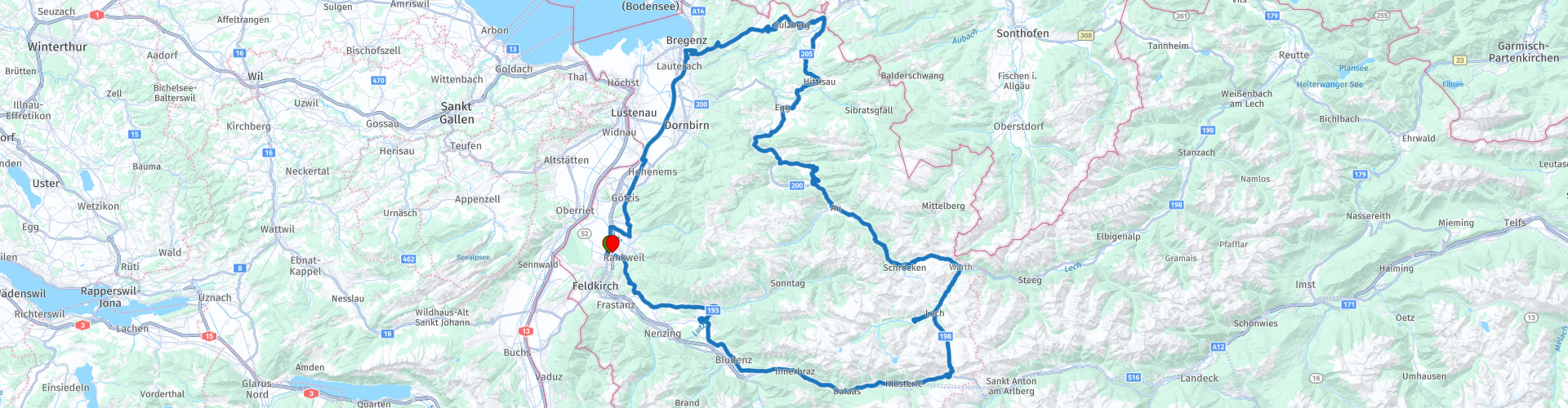
Vorarlberg roundtrip 2 Rankweil to Bregenz to the Arlberg

This route was brought to you by:
RouteXpert Edgar Hofer
Last edit: 03-04-2023
 Route Summary
 This is the 2nd route in my Vorarlberg circular tours collection.
This tour leads "Around Vorarlberg". Through the Bregenzerwald to the Arlberg, past very beautiful vantage points and through beautiful landscapes.
Start and finish: Rankweil (gastronomy workshop)
Course: Rankweil - Bregenz - Sulzberg - Hittisau - Schnepfau - Schoppernau - Schröcken - Hochtannbergpass - Lech - Flexenpass - Klostertal - Rankweil
The route is identical for TomTom, Garmin and MyRoute app.
If you drive this tour, please note the following information:
● some mountain experience necessary
● The Warth – Lech connection, depending on snow conditions, only opens towards the end of April at the beginning of May.
● A motorway vignette is not required for this tour. However, I recommend buying a vignette for a longer stay in Austria. (Motorcycle: 10 days EUR 5.80; 2 months EUR 14.50).
I give this tour 5 stars. It offers everything that a great motorcycle tour needs. Fantastic landscapes, beautiful views and very good roads.
 Share this route


Animation

Verdict


Duration
6h 49m

Mode of travel
Car or motorcycle

Distance
207.66 km

Countries


 RouteXpert Review
 That is why this tour is a typical “Ländle tour”. Like the first tour, the tour starts at the workshop in Rankweil and leads through the Rhine Valley to Bregenz.
A small detour leads via St. Arbogast to Götzis. In St. Arbogast you will see the walls of Neu-Montfort Castle. Built between 1311 and 1319 by the Counts of Montfort, it was pledged to Hugo Thumb von Neuburg in 1362. However, in the same year it was forcibly taken away by Rudolf III of Montfort-Feldkirch. With the death of Rudolf IV of Montfort-Feldkirch in 1390, Neu-Montfort fell to the House of Habsburg on the basis of a treaty. Today you can still visit the remains of the keep and enjoy the fantastic view over the Rhine Valley. The castle can be reached in a few minutes on a narrow path.
From Hohenems, take the Autobahn in the direction of Bregenz. A vignette is not required from Hohenems to Bregenz. On the way to Bregenz-Fluh you will pass one of the best vantage points for Lake Constance. Depending on the weather, almost the entire Lake Constance can be overlooked. The Festspielhaus with its floating stage can also be seen from there.
The Bregenz Festival is a lake festival that takes place annually in July and August in Bregenz. The main attraction for a large number of visitors is the play on the lake, which is offered in two summer seasons on the world's largest lake stage; usually an opera production, always together with the Wiener Symphoniker. The festival is known for the beauty of the natural backdrop of Lake Constance, oversized stage sets, technical showpieces and unique acoustics.
In the spring of 2008, the James Bond film A Quantum of Solace was also filmed on the lake stage, and ZDF also made guest appearances on the lake stage with the EM studio for daily reporting during the 2008 European Football Championship.
The tour continues on the Langener Straße to Sulzberg. Especially the approach to Sulzberg offers everything that makes a motorcyclist's heart beat faster.
That's why a coffee break is the order of the day in Sulzberg. Coffee can be enjoyed on a beautiful terrace with a magnificent view of the Bregenzerwald.
The next few kilometers of the tour run precisely through this landscape, which you had just seen on the terrace. Shortly before Hittisau, the engine is switched off again to take a few more souvenir photos of the surrounding, grandiose landscape.
You continue to the rear Bregenzerwald. After Andelsbuch you will pass a beautiful wooden barn. This serves as a showroom for the motorcycle dealer Scalet. Harley Davidson and Indian brand motorcycles are displayed for sale here. If you have some time, a short stop is also worthwhile. The owner is always looking forward to a nice chat.
In Bezau you leave the main road and drive to Bizau to drive via Schnepfegg. You will pass the Berghaus Kanisfluh. This inn has a magnificent terrace and offers excellent local food. For today's tour, however, it is still too early for lunch. That's why today they only enjoy the beautiful view of the landmark of the Bregenzerwald, the Kanisfluh. On a later tour of mine, lunch will be planned here.
You drive on and you will notice that the valley gets narrower and narrower. The ascent to Schröcken and the first pass of today's tour, the Hochtannbergpass, begins shortly after Schoppernau. This driveway also offers everything a motorcyclist dreams of.
The journey continues to Warth in a relaxed manner. Although the road is well developed and has no confusing curves, caution is advised. Don't be distracted by the breathtaking scenery!
The tour continues to Lech. One of the most famous ski resorts in the Alps and for many years the holiday resort of the Dutch royal family. The road to Lech is well developed, but contains a few confusing curves. Therefore, caution is required here and precise cornering is necessary.
Arrived in Lech, it's time for lunch. The range of gastronomy in Lech is also very large in summer. When driving through Lech, you will surely find something. But if you want to eat fish, I can definitely recommend the fish pond in Lech (pt. 30). The fish pond is a beautifully situated pond with excellent food.
On a very well-developed road you continue to Zürs and the Flexenpass. Through the gallery, shortly after the Flexenpass, some concentration is necessary again, after that a very well-developed road meanders down to Stuben.
After Stuben, the tour leads through the Klostertal to Bludenz. If you have a motorway vignette and want to shorten the tour, you can take the direct route on the motorway from point 39 to Rankweil. A short detour to the Große Walsertal will be made on the planned route. This detour is highly recommended, as the road to Satteins offers wonderful views.
The “Schwarzer See Stüble” is ideal for reviewing today’s impressions. But you're sure to find a nice spot on the terrace of the Rankweil workshop.


 Links
Links  Usage
Usage Want to download this route?
You can download the route for free without MyRoute-app account. To do so, open the route and click 'save as'. Want to edit this route?
No problem, start by opening the route. Follow the tutorial and create your personal MyRoute-app account. After registration, your trial starts automatically.  Disclaimer
Use of this GPS route is at your own expense and risk. The route has been carefully composed and checked by a MyRoute-app accredited RouteXpert for use on TomTom, Garmin and MyRoute-app Navigation.
Changes may nevertheless have occurred due to changed circumstances, road diversions or seasonal closures. We therefore recommend checking each route before use.
Preferably use the route track in your navigation system. More information about the use of MyRoute-app can be found on the website under 'Community' or 'Academy'.

Vorarlberg
About this region
Vorarlberg ( FOR-arl-burg, Austrian German: [foːɐ̯ˈarlbɛrk] (listen); Vorarlbergisch: Vorarlbearg, Voralbärg, or Voraadelbearg) is the westernmost state (Land) of Austria. It has the second-smallest geographical area after Vienna and, although it has the second-smallest population, it also has the second-highest population density (also after Vienna). It borders on three countries: Germany (Bavaria and Baden-Württemberg via Lake Constance), Switzerland (Grisons and St. Gallen), and Liechtenstein. The only Austrian state that shares a border with Vorarlberg is Tyrol, to the east.
The capital of Vorarlberg is Bregenz (29,698 inhabitants), although Dornbirn (49,845 inhabitants) and Feldkirch (34,192 inhabitants) have larger populations. Vorarlberg is also the only state in Austria in which the local dialect is not Austro-Bavarian, but rather an Alemannic dialect; it therefore has much more in common culturally with (historically) Alemannic-speaking German-speaking Switzerland, Liechtenstein, Swabia, and Alsace than with the rest of Austria, southeastern Bavaria, and South Tyrol.
Vorarlberg is to a large extent mountainous. About 37% (97,000 hectares) of its surface is forest.
Read more on Wikipedia
The capital of Vorarlberg is Bregenz (29,698 inhabitants), although Dornbirn (49,845 inhabitants) and Feldkirch (34,192 inhabitants) have larger populations. Vorarlberg is also the only state in Austria in which the local dialect is not Austro-Bavarian, but rather an Alemannic dialect; it therefore has much more in common culturally with (historically) Alemannic-speaking German-speaking Switzerland, Liechtenstein, Swabia, and Alsace than with the rest of Austria, southeastern Bavaria, and South Tyrol.
Vorarlberg is to a large extent mountainous. About 37% (97,000 hectares) of its surface is forest.
View region
 Statistics
  15
15Amount of RX reviews (Vorarlberg)
 16048
16048Amount of visitors (Vorarlberg)
 1232
1232Amount of downloads (Vorarlberg)
 Route Collections in this region
 The 24 Most Beautiful Alpine Routes
The Alps, The Alps are a mountain range in Europe, stretching from the French Mediterranean coast in the southwest to the Pannonian Plain in the east. The area of the mountain range is more than 200,000 km².
In other words Passes and Mountain Roads!
Driving through the mountains is great! Especially over the mountain passes with hairpin bends and narrow winding roads. Every bend a different view where you can enjoy. There are many beautiful mountain passes in the Alps.
A selection that has also been incorporated into these routes:
The Stlevio Pass:
The Stelvio Pass, also known as Passo dello Stelvio, is mainly known for the stage in the Giro d'Italia. Due to the length and the difference in height, this pass is seen as one of the toughest tests in cycling. The Stelvio Pass reaches a maximum height of 2758 meters and is therefore one of the highest in the Alps. The pass connects the towns of Bormio and Prato Allo Stelvio. In winter the pass is closed due to heavy snowfall.
The Reschenpass:
The Reschenpass, also known as Passo di Resia, connects the Austrian state of Tyrol with the Italian province of South Tyrol. The pass reaches a maximum height of 1,504 meters and has been one of the most important north-south connections in the Alps in recent centuries. The pass was used long before Roman times. Along the way you will pass several highlights and historical relics. One of the highlights is the Reschensee. This lake was created after the construction of the dam and has completely submerged the village of Graun. The only thing that reminds of that is the clock tower in the middle of the lake.
Col du Galibier:
The French mountain pass Col du Galibier connects the towns of Saint-Michel-de-Maurienne and Briançon via the Col du Lautaret in the south and the Col du Télégraphe in the north. The mountain pass is part of the Tour de France and very much feared, due to the fact that it can only be reached via the other two mountain passes. The pass reaches a maximum height of 2646 meters. From there you can take a walk to the viewpoint at 2704 meters. You can admire the peaks of the Grand Galibier, Mont Blanc and La Meije here.
The Grossglockner High Alpine Road:
With a height of 3798 meters the Grossglockner is the highest mountain in Austria. To fully enjoy this impressive mountain, you can drive over the Grossglockner High Alpine Road and the accompanying pass. The route starts from Bruck am Grossglockner and ends in Heiligenblut. Of course you can drive in two directions. The pass reaches a maximum height of 2504 meters and is closed in winter due to heavy snowfall. Along the way you pass several stops with fun activities, information points, mountain huts and viewpoints. A visit to the Kaiser-Franz-Josefs-Höhe and Pasterzen Glacier is highly recommended.
The Col d'Izoard:
Just like the Col du Galibier, the Col d'Izoard is also part of a stage of the Tour de France. The mountain pass connects Briançon with the valley of the river Guil. The pass is partly located in the Regional Natural Park du Queyras and reaches a maximum height of 2360 meters. What is special about the Col d'Izoard is the barren and rocky landscape. Sometimes it feels like driving a car over the moon! Along the way you can stop at several points to enjoy the beautiful view.
The Bernina Pass:
The Bernina Express is one of the most famous rail trains in Switzerland and the Alps. The route is beautiful and partly included on the UNESCO World Heritage List. Parallel to the railway lies the Bernina pass, which connects the Veltlin valley with the Egandin valley. This beautiful Alpine road has a total length of 56 kilometers and reaches a maximum height of 2328 meters. Along the way you can enjoy views of the Morteratsch Glacier.
The Sella Pass:
The Sella Pass, also known as Passo di Sella, takes you over one of the most impressive mountain ranges in the Dolomites: the Sella massif. The pass connects Valle di Fassa with Val Gardena and reaches a maximum height of 2236 meters. At this height is also the border of the Italian provinces of Trentino and Bolzano. Along the way you can enjoy the view of this spectacular mountain world. Admire, for example, the three peaks of the Sasso Lungo massif, the Sella massif or the peaks of the Marmolada. You can also drive the Sella pass in combination with the Gardena pass, Pordoi pass and Campolongo pass.
The Grimsel Pass:
The Grimsel Pass connects Goms in Wallis with the Halis Valley in the Bernese Oberland. The pass reaches a maximum elevation of 2165 meters and is closed in winter due to snowfall. Over the centuries, the mountain pass has played an important role in trade between Switzerland and Italy. Now it is mainly the reservoirs that have an important function. These are used to generate electricity. The landscape you drive through is rugged, rocky and impressive. On top of the pass is a hotel and a restaurant with a special marmot park. The Dodensee (Totensee) is also located here. This lake owes its name to the many soldiers who died in the time of Napoleon.
The Gotthard Pass:
The Gotthard Pass, also known as Passo del San Gottardo and Saint Gotthard, connects the Swiss towns of Airolo and Andermatt. The mountain pass and associated tunnel are especially known among holidaymakers driving from Switzerland to Italy. But where the majority opt for the tunnel, it is precisely the pass that really completes the holiday. The Gotthard Pass has a length of about 26 kilometers and reaches a maximum height of 2106 meters. The route is beautiful and takes you along old villages and beautiful views.
The Silvretta High Alpine Road and Silvretta Pass:
The Paznaun Valley in Tyrol and the Montafon in Vorarlberg are connected by the Silvretta High Alpine Road. The route has a length of 22.3 kilometers and leads from Galtür to Partenen in 34 hairpin bends, via the 2032 meter high Bielerhöhe. The Silvrettasee is also located at this point, where you can enjoy a lovely walk. The pass is closed in winter due to snowfall.
The Simplon Pass:
Just like the Gotthard Pass, many holidaymakers also travel over the Simplon Pass every year. This mountain pass connects the Rhone Valley in the canton of Valais with the Valle d'Ossola in Piemonte. The pass is open all year round and reaches a maximum height of 2005 meters. Along the way you pass a number of buildings, including the well-known Simplon Hospiz from 1825. The hospiz is managed by the monks of St. Bernard. From the highest point on the pass, all kinds of hiking routes are possible and you will also come across a hotel where you can spend the night.
The Gerlos Pass:
The Gerlos Pass connects the Salzach Valley in the Salzburgerland with the Zillertal Valley in Tyrol. The pass is part of the Gerlos Alpenstraße and runs right through the Hohe Tauern National Park. Along the way you can enjoy beautiful views of the surroundings. The pass has a length of 12 kilometers and reaches a maximum height of 1531 meters. A ride over the Gerlos Pass can be ideally combined with a visit to the Krimmler Wasserfälle.
The Great St. Bernard Pass:
The Great St. Bernard Pass, better known as Col du Grand Saint Bernard, connects the Italian province of Valle d'Aosta with the Swiss canton of Valais. The pass is one of the highest in Switzerland and reaches a maximum height of 2469 meters. Like a number of other mountain passes in this list, the Great St. Bernard Pass has also been used as a connecting road for centuries. The pass is named after the St. Bernard dogs that used to help stranded travelers along with the monks. The pass is closed in winter.
The Timmelsjoch High Alpine Road:
The Timmelsjoch High Alpine Road connects the towns of Sölden in the Ötztal and Meran in South Tyrol. Tolls must be paid on the Hochgurgl - Moos route. Via a mountain road with about 60 hairpin bends you drive through a beautiful mountain world. With the Timmelsjoch Experience you can learn more about the history, the road and the environment via various stations. You can also visit the Top Mountain Crosspoint museum.
Col de l'Iseran:
With a maximum pass height of 2770 meters, the Col l'Iséran is one of the highest mountain passes in the Alps. The pass connects Bourg-Saint-Maurice with Bonneval-sur-Arc. Via a road full of hairpin bends you pass, among other things, Val-d'Isère and a side valley of the Maurienne that lies entirely in the National Park de la Vanoise. You can spot animals such as marmots and chamois and there is also a restaurant with a chapel on top of the pass.
The Gavia Pass:
The Gavia Pass (Italian Passo di Gavia) is a mountain pass in the Italian Alps, in the Lombardy region.
It is one of the highest pass roads in Europe. The road leads through the unspoilt Stelvio National Park. The road was built in the First World War to supply Italian soldiers who fought in the Italian-Austrian border area. The pass height is one of the most beautiful in the Alps. Here is the large Lago Bianco with, to the north, the mountain San Matteo (3684 meters). Lago Nero is slightly lower on the south side of the pass. Here the mountain group of the Adamello determines the view. There are many well-marked walks in the area. During the winter the pass is closed due to the heavy snowfall. The pass is often closed until May and June due to the large amount of snow.
Promoter has made a selection of the 24 Most Beautiful Alpine routes that they have set out in recent years.
The routes go through:
France
Austria
Switzerland
Italy
The most beautiful roads, the most beautiful views, the most beautiful viewpoints. The highest mountains, the fastest descents, hairpin bend after hairpin bend, you name it you can't get enough of it.
If you go on holiday in this region, take advantage of it, ALL routes in this collection have been checked and made equal for TomTom, Garmin and MyRoute-app Navigation by a MyRoute-app RouteXpert.
Have fun with this collection and while driving one of these routes. Enjoy all the beauty that the Alps and the Dolomites have to offer. Click on “View route” to read the review of the chosen route.
I would like to hear your findings about the route(s).
View Route Collection
11 day trip from the Netherlands
8 countries in 11 days; The Netherlands, Germany, Austria, Italy, Switzerland, France, Luxembourg and Belgium. This route collections consists of 10 routes that I have driven with friends in the summer of 2019.
The start is in Geldermalsen Netherlands, the first 7 days you drive through the Netherlands, Germany, Austria, Italy, Switzerland, France and a piece of Luxembourg with overnight stays in hotels.
The last three days you stay in Barweiler (D) in the Eifel and you drive two beautiful tours through the Eifel, Luxembourg and parts of the Belgian Ardennes.
There is no highway in the routes, only beautiful provincial and country roads, many beautiful passes with beautiful panoramas.
Be sure to check whether the passes are open before you leave.
These are routes for experienced drivers.
View Route Collection