06 TAS Strathgordon to Strahan

This route was brought to you by:
RouteXpert Hans van de Ven (Mr.MRA)
Last edit: 11-02-2023
 Route Summary
 Tasmania is known for its many national parks, green rugged landscapes and the Tasmanian Devil. Only a few living specimens of the Tasmanian Devil are known. Much of the island is untouched and designated as a national or wildlife park. In addition, one can find many waterfalls in Tasmania. Tasmania's coastline is mountainous with a number of white sand beaches. In the waters around Tasmania you can dive and snorkel to the colorful underwater life. Tasmania has a diversity of flora and fauna; the most diverse types of plants, trees and animals, especially birds and a lot of typical Australian marsupials, which you will not find anywhere else in the world!
You're going to see and experience it all in this 5 star rated amazing tour of Tasmania, a tour that also visits the capital Hobart is one to remember!
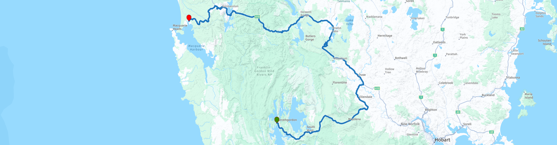
Starting Point: Strathgordon, Pedder Wilderness Lodge
End point: Strahan, Strahan Village
ATTENTION: DRIVE LEFT!
 Share this route


Animation

Verdict


Duration
8h 13m

Mode of travel
Car or motorcycle

Distance
337.61 km

Countries

 RouteXpert Review
 The route mainly goes through a beautiful green, quiet area where you will almost feel alone in the world. In the town of Tarraleah you can stop for something to eat and/or drink, and get to know the locals.
You will also stop at the Early Surveyors Centre, The Tasmanian Division of the Institute of Surveyors decided to erect a monument to the early surveyors who explored and mapped the state.
Where you will definitely stop a little longer is: The Wall in the wilderness. Greg Duncan began sculpting a wall 10 feet high and over 100 feet long on March 1, 2005 in one of the most beautiful parts of Tasmania. The material would be Huon Pine. Book your tickets online in advance! (https://thewalltasmania.com.au/)
Be surprised in Suprise Valley, truly amazing views. Or take a short walk to Nelson Falls. A delightful short walk from the Lyell Highway takes you along a babbling river to a stunning series of waterfalls. The mossy forest, with sassafras, myrtle and a variety of ferns, indicates high rainfall in this area. These falls are always a beautiful sight, but can be a spectacular roaring deluge after heavy rainfall. You go back via the same track.
You will also take a look at the Iron Blow Lookout. This gives you a glimpse into Tasmania's troubled mining history. Gold was discovered in the hills of the Linda Valley on Tasmania's west coast in 1883 at a site called the Iron Blow. Miners came to the site to discover much more profitable copper deposits. They then ravaged the land to expose it before leaving the nearby mining ghost towns of Gormanston and Linda. Then another stop at a viewpoint. But above all enjoy the beautiful, peaceful surroundings. Just before you reach the end point, refuel and do some shopping and then review the impressions of this day one more time. This, of course, while enjoying a snack and a drink.
Info Tasmania:
Tasmania was connected to the Australian mainland for most of the past 100,000 years. As a result, it was probably populated quite soon after the arrival of the first explorers in Australia. The first Australians may have arrived on the continent as early as 60,000 years ago. Tasmanians looked like dark Africans. They were quite large: the men averaged 5'6" to 5'7", but some were up to 2' tall. The oldest archaeological sites on the island are Warreen Cave, estimated to be 34,790 years old, and Parmerpar Meethaneer Cave, which is between 44,200 and 34,000 years old. The stone tools of the Tasmanians were quite primitive compared to those of other modern humans. The island became separated from the mainland again about 8,000 years ago. Subsequently, this underwent considerable development, while in Tasmania some techniques, such as those of tools with handles, were even lost. The Tasmanians lived as hunters and gatherers. They numbered, according to estimates, between 3,000 and 10,000 people. There were several tribes that regularly fought among themselves. The Tasmanians, like people elsewhere, made art, including rock art.
The governor of the Dutch East Indies, Antonie van Diemen, commissioned Abel Tasman on a voyage of discovery to mainland Australia. On his journey, Tasman discovered the island that was later named after him on November 24, 1642. He named it after his client: Van Diemensland. At the end of the 18th century, the English colonized the island and took English and Irish deportees there. After these deportations from England were stopped, the Vandiemenslanders changed the name of the island to 'Tasmania' on January 1, 1856, after its Dutch discoverer. The capital Hobart is, after Sydney, the oldest city in Australia. In 1803, the English governor, John Bowen, declared martial law. The original Tasmanians (Aboriginals) were almost completely wiped out until 1830. There are no direct descendants of Tasmanians left, only people who are descended from female Tasmanians and Europeans. The last full-blooded Tasmanian, Trucanini, died in May 1876. Although the island is the smallest state, there are approximately 500 self-contained protected areas, totaling 40% of Tasmania's land area. For example, the Styx Valley is threatened by logging companies and many other nature areas that are not protected are also threatened with total destruction. Nevertheless, the Tasmanian wilderness is a World Heritage Site in terms of nature and culture.
There are two types of predatory marsupials in Tasmania. For example, the island is the only place where the Tasmanian devil still roams, a 60 cm long, carnivorous and black and white colored marsupial, known for its great voracity and ferocity. Since the late 20th century, the number of Tasmanian devils has been visibly declining. This is the result of, among other things, a tumor disease. Another predatory marsupial mainly found in Tasmania is the spotted marsupial, a marsupial averaging 35 cm in length with a white-spotted, light brown color. Until the early 1930s, Tasmania was also the only area where the marsupial wolf (or Tasmanian tiger) still lived, but the last specimen of this predatory marsupial animal died in 1936 at Hobart Zoo. Tasmania is home to a number of other animals that are not (or no longer) found anywhere else. The Pseudomys higginsi is an approximately 13 cm large rodent, which mainly lives in the higher forests. The red-bellied pademelon is a brownish kangaroo about 60 cm high that only jumps around in Tasmania. The Tasmanian bristle-tailed kangaroo rat is a 12-inch (30 cm) long, brownish-gray kangaroo rat that lives only in Tasmania and moves at night and on the ground.
The Tasmanians were the indigenous people of the Australian state of Tasmania. Today, however, they are considered extinct as there are no full-blooded Tasmanians left. The people disappeared (due to murders and European diseases) in the years after the European colonization of Tasmania. The last full-blooded Tasmanian, a woman named Truganini, died in 1876.
The descendants of the Tasmanians still live in Tasmania, but much of their original culture and language has been lost. However, since the 1970s, attempts have been made to revive this culture.


 Links
Links  Usage
Usage Want to download this route?
You can download the route for free without MyRoute-app account. To do so, open the route and click 'save as'. Want to edit this route?
No problem, start by opening the route. Follow the tutorial and create your personal MyRoute-app account. After registration, your trial starts automatically.  Disclaimer
Use of this GPS route is at your own expense and risk. The route has been carefully composed and checked by a MyRoute-app accredited RouteXpert for use on TomTom, Garmin and MyRoute-app Navigation.
Changes may nevertheless have occurred due to changed circumstances, road diversions or seasonal closures. We therefore recommend checking each route before use.
Preferably use the route track in your navigation system. More information about the use of MyRoute-app can be found on the website under 'Community' or 'Academy'.