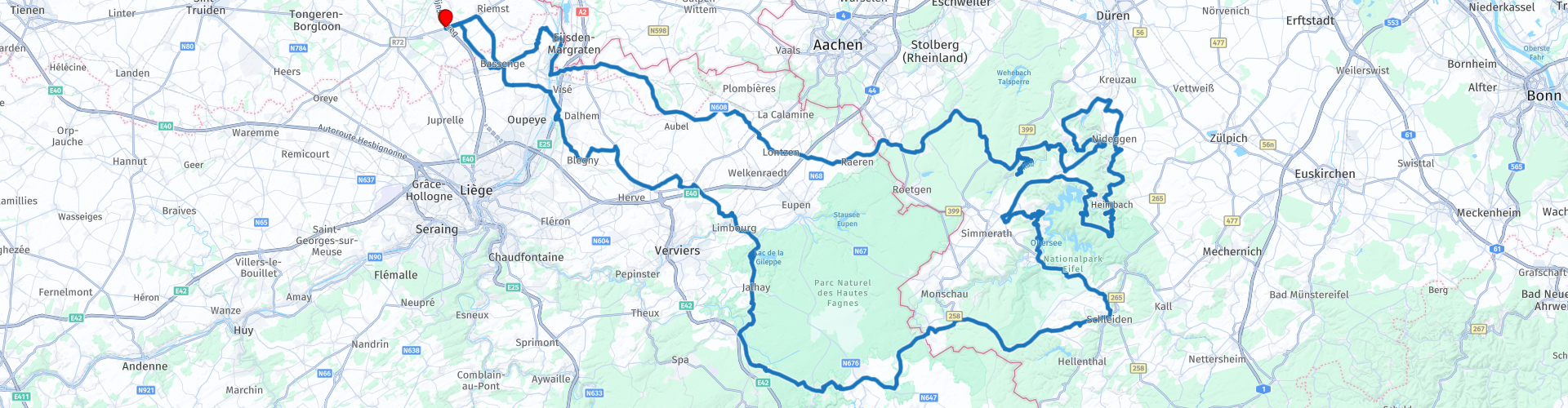
Eifeltour out of Tongeren via Vogelsang and Lake Gileppe

This route was brought to you by:
RouteXpert Guy Heyns - Adv. RouteXpert
Last edit: 10-12-2024
 Route Summary
 Driving this tour, you will pass through several interesting areas with both historical & geological value. The Albert Canal, so brandnew and so important in WW II, The Meuse river that has given so much pleaseure & economic value, the 'Voer' in Belgium where a lot of 'battles' were won by the Flandriens, and of course, the High Fens, home of the favorite meal of Asterix & Obelix townmates ....
So, be carefull when you drive those woods .... and don't forget to enjoy the Eifel curves near the Ruhrsee ..
So close to Belgium & the Netherlands and so nice to drive ..... Hop on this tour & enjoy it!
 Share this route


Animation

Verdict


Duration
6h 39m

Mode of travel
Car or motorcycle

Distance
317.83 km

Countries


 RouteXpert Review
 The departure of this tour is at Tongeren, the oldest city in Belgium. The main market there is decorated with a statue of Ambiorix & the Gallo-Roman museum in the city is internationally renowned. Gauls, Ambiorix, Romans… it is very reminiscent of the comics of Asterix & Obelix. So be careful as you drive through the vast forests of this pleasant tour. They will undoubtedly have eaten a lot of wild boars those Gauls, but there are still a lot of them around, so beware of crossing game. You will not be the first or the last to be suddenly treated to a surprise by Mother Nature during your passage through the vast High Fens and the Eifel region.
Shortly after departure at the Pauze, the place of departure and arrival, you will come across a petrol station at route point 2. We would be happy to advise you to fill up the fuel properly, price-wise. After all, German petrol is a lot more expensive today. In addition, you may have to queue at the petrol stations in the Eifel. You will not be the only one there to enjoy a nice sunny day.
Between rp 4 and rp 9 you flirt with the Flemish-Walloon border. Consider the differences in speed. In Flanders 70 is the norm, while in Wallonia you can drive smoothly at 90. Interesting to know, especially when you drive back into Flanders. Watch out for official hobby photographers who would like to give you a (reasonably expensive) memory of this otherwise pleasant trip.
Just after rp 5 and 6 (take a short break at the lookout point if you have room to stop…) you will pass an important area. The Albert Canal played a crucial role in World War II and, together with the Maas, the canal provides enormous prosperity from Liège to Antwerp. It not only connects these cities, but also the Maas with the Scheldt. Thanks to the canal, the city of Antwerp can be reached from Liège in 18 hours instead of 8 days. A world of difference.
At route point 12 you cross the German border and see the first deep forests emerge of the High Fens, the largest nature reserve in Belgium that extends far beyond the German borders. It also flows seamlessly into the German Eifel region, which you can safely compare with the Belgian Ardennes. Only the road surface is much, much better…. .
From route point 15, various establishments in Simonskall are marked where you can make a short stop. Landhotel Kallbach is known for its tasty lunches. If you have a picnic with you and want to take a break in the 'open air', you will find some stops marked after rp 16 where you can plan a small stop for a short (coffee) break if you wish. Plenty of place (s) to do this and it is also recommended. All the more because after these stops you can enjoy the many Eifel bends in one trek that will reduce the pubic area on your tires. Enjoy from here to rp 24, the obligatory stop at the famous Biker Ranch, perhaps very well known by many. The place to take a longer break, to enjoy a (German) snack and a drink and to meet fellow sufferers who, just like you, enjoy what the beautiful nature has to offer here.
After this stop, the route meanders nicely and also takes you past the infamous Vogelsang fort, the former training center of the Nazis, which lies in the middle of the beautiful Eifelse Nature Park.
Once past this, the route slowly takes you back to the German border and the High Fens, and this through vast, imposing forests and forests. We would like to repeat the warning to always be on the lookout for common and crossing wildlife.
Once back in Belgium, you will pass the Gileppe reservoir at rp 34. If you would like to take a break, then a visit to the tower that overlooks Lake Gileppe is highly recommended. However, beware… the parking is prone to theft during the season….
Just after rp 39 you will again pass the Maas and the Albert Canal. Again, pay attention to the industry that lives off these two waterways. Shortly after crossing the Albert Canal you can return a tank at rp 41, after which you quickly reach the final destination of this route; the Pause, wherever you started this route.
The route can be enjoyed by everyone as a fun day trip. Due to the technicality of some Eifel bends, some may be a bit slower than others, but in general the route is really suitable for everyone. It also runs on excellent road surfaces and offers more than enough variation. That's why the route gets a five-star rating from us. So close and so nice to drive. An absolute must for anyone who wants to get a taste of the better German road network. But beware… once tasted …… We are therefore not responsible for further household consequences. Your next trip to the Eifel will probably not be long…. You arrange it yourself at home ...


 Links
Links  Usage
Usage Want to download this route?
You can download the route for free without MyRoute-app account. To do so, open the route and click 'save as'. Want to edit this route?
No problem, start by opening the route. Follow the tutorial and create your personal MyRoute-app account. After registration, your trial starts automatically.  Disclaimer
Use of this GPS route is at your own expense and risk. The route has been carefully composed and checked by a MyRoute-app accredited RouteXpert for use on TomTom, Garmin and MyRoute-app Navigation.
Changes may nevertheless have occurred due to changed circumstances, road diversions or seasonal closures. We therefore recommend checking each route before use.
Preferably use the route track in your navigation system. More information about the use of MyRoute-app can be found on the website under 'Community' or 'Academy'.