MTG2 23 Gent Tielt Hondschoote Bergues Ardres Mimoyecques Wissant

This route was brought to you by:
RouteXpert René Plücken (MRA Master)
Last edit: 12-02-2021
 Route Summary
 climate. It is not for nothing that you see so many motorcyclists there. My previous series of routes in France were based on the route descriptions from the Motortourgids France part 1 made by Bert Loorbach.
This route comes from Motortourgids France part 2 and the original name is "Nord-Pas de Calais; Route description 1st route: French Flanders".
In Motorbike guide France part 2 a difference has been made between approach routes and trips in a certain area. The approach routes can also be used in combination with the routes from Motortourgids France part 1
The routes are sometimes slightly adjusted based on the tips that Bert Loorbach gives in his description, or because of a different place to spend the night, or to achieve the minimum length of 2 hours for the MRA Library. For each route there is a more detailed description in the review, including options to stay overnight or places of interest en route, which are also indicated with a POI and if possible with a short description
The route is made suitable for Garmin, TomTom, Harley-Davidson BoomBox 2019 and Navigation App, can be downloaded for free and without My-Route-app registration. To do this, first click on the 'Use route' button and then on 'Save as'.
 Share this route


Animation

Verdict


Duration
4h 1m

Mode of travel
Car or motorcycle

Distance
198.88 km

Countries


 RouteXpert Review
 This is the first of two surprising trips close to home, both of which can also be used as approach routes, or as part of a trip further south.
The approach route for both routes is via the highway from Ghent if you want to hurry up, but there are also better alternatives on the nicer N and D roads, I have included these in the original routes.
It is a bit of a mixture of Flanders and France, we come across mills and canals, but also rugged coasts and fortified cities. Along these tours you will also find traces and memories from the Second World War everywhere, such as a series of fortress cities, some of which are still completely intact, such as Bergues in the first route.
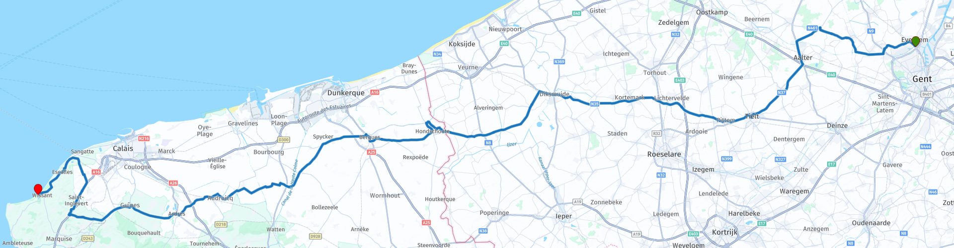
The starting point is the McDonalds at the R4-N456 traffic square near Ghent.
From here we drive through the villages of Belzele, Ursel in the direction of Tielt (RP5), in the center of this small town there are several cafés for a break for a nice cup of coffee. The Halletoren (Belfort van Tielt) is located on the square in the city.
Then we drive via Lichtervelde and Diksmuide on the N35 and the N364 to Hondschoote in France. Especially after Diksmuide this is a very nice route where you enter France on a very small and rural road. There are large pieces with concrete slamming slabs, so a kidney belt is advisable.
Just outside the town of Hoogschoote is RP10 De Noordmeulen (Moulin du Nord), a post mill that was used as a flour mill. The Noordmeulen dates from at least 1547 and is therefore the oldest windmill in the north of France and even the oldest windmill in Europe. The foundations date from 1127.
Arriving in Hondschoote (RP12) you are also at the starting point of the original route as described in the Motorbike Guide France part 2.
The next place is Bergues (RP13). This is a fortified town with beautiful city walls, gates and a spacious square. So definitely worth stopping here to stretch your legs for some sight seeing. When leaving the city you drive at RP14 through the Gates of Dunkirk, part of the old city walls.
After this we follow the canal of the Colme and you almost imagine yourself in the north of the Netherlands among the fields, farms and straight roads and canals. At RP15, cross the canal over a concrete bridge.
Not only does the landscape affect the Netherlands, the place names are also more Dutch than French; such as Kappellebroek, Sint Pietersbroek and Ouderwijk (Audruicq).
We continue on a winding road to Audruicq and Ardres (RP17). This last place has a beautiful lane with shady linden trees that you come straight to. There is also a nice triangular square with old houses and a number of restaurants in the center are ideal for planning lunch here.
In Gumes (RP19) the last and also the most beautiful part of the journey towards Cap Blanc-Nez starts. This is also well signposted after the village. We drive here on winding roads through the north of the Parc Naturel Régional des Caps et Marais d'Opale via Landrethun-de-North to St. Inglevert.
Those interested in the Second World War can visit the Fort of Mimoyecques (RP20). This is located exactly 150 kilometers from London and was intended as the basis for the V3 rocket, the successor of the V1 and V2. This was meant to wipe London off the map. For this, the German
sers immense cannons invented 130 meters long, which had to be placed underground. The huge structure was literally leaked in July 1944 by an Allied 'Tallboy' bomb. The complex can now be viewed.
After this we continue to RP22 to drive along the Côte Opal (Opal coast) to the Cap Blanc-Nez (RP23) on the Channel. Its summit is 134 m above sea level. Cap Blanc-Nez is located 16 km northeast of Cap Gris-Nez. The cape can be reached on foot and by car. There is a walking path from the top of the cape to the beach. Here the view is wide! With clear weather you can easily see the English coast and the many ferries that operate the regular services. This cape owes its name (Cape White Nose) to the white chalk cliffs and to the fact that the cape looks a bit like a nose.
We drive to the terminus Wissant (RP25), this is one of the nicer places on this Opal coast. It really still breathes the atmosphere of a small old fishing village. There is a huge beach that has also been discovered by windsurfers. the atmosphere is friendly and calm. Here you can enjoy a wonderful moment on the beach of this beautiful day before you spend the night in one of the many hotels or on a campsite.
This is a beautiful route with a lot of history, the roads are beautiful, good but not spectacular, so I rate this route with 4 **** Stars.


 Links
Links  Usage
Usage Want to download this route?
You can download the route for free without MyRoute-app account. To do so, open the route and click 'save as'. Want to edit this route?
No problem, start by opening the route. Follow the tutorial and create your personal MyRoute-app account. After registration, your trial starts automatically.  Disclaimer
Use of this GPS route is at your own expense and risk. The route has been carefully composed and checked by a MyRoute-app accredited RouteXpert for use on TomTom, Garmin and MyRoute-app Navigation.
Changes may nevertheless have occurred due to changed circumstances, road diversions or seasonal closures. We therefore recommend checking each route before use.
Preferably use the route track in your navigation system. More information about the use of MyRoute-app can be found on the website under 'Community' or 'Academy'.