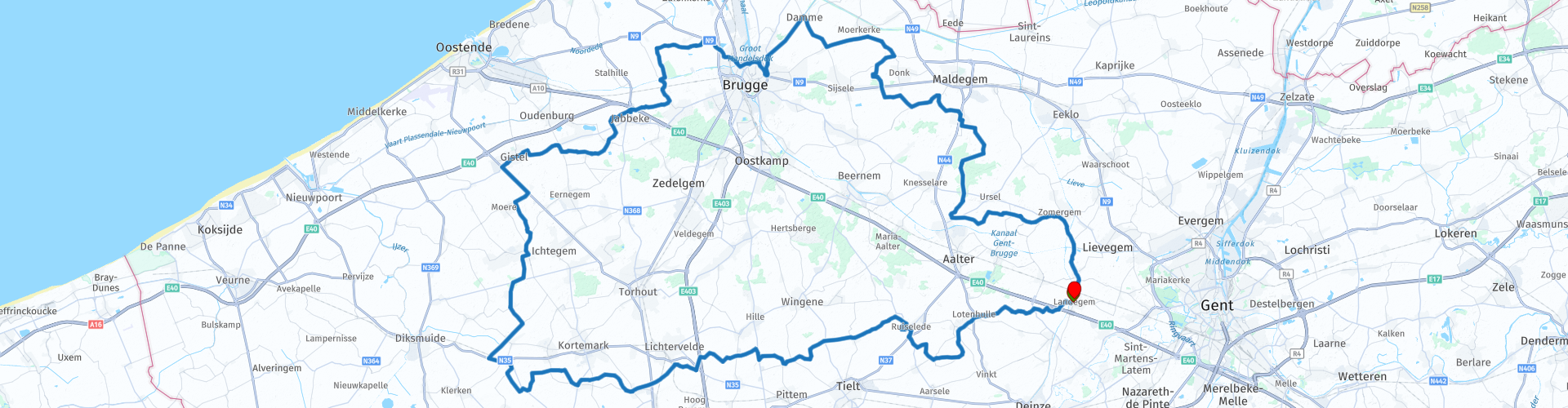
Roundtrip from Landegem along 14 windmills

This route was brought to you by:
RouteXpert Catherine De Groote RouteXpert
Last edit: 08-01-2021
 Route Summary
 You usually drive along quiet roads, here and there a mill and, like everywhere in Flanders, numerous chapels.
 Share this route


Animation

Verdict


Duration
5h 37m

Mode of travel
Car or motorcycle

Distance
177.30 km

Countries

 RouteXpert Review
 The Meetjesland consists in the north of the creek area and in the south the Houtland. The Houtland that you cross is the most wooded area in East Flanders and owes its name to the extensive forests. The parcels of agricultural land are bordered by rows of pollard willows, reed hedges and bushes. Some channels draw straight lines through the Meetjesland. With its 550 ha, the Drongengoed is the largest contiguous forest area in East Flanders. The forest is an important remnant of the medieval forest between Ghent and Bruges.
The Brugse Ommeland is a surprisingly green region with picturesque village views. Green recreational axes form the Damse Vaart and the Ghent-Ostend canal. In the north around Damme, the landscape extracted at sea is open. To the south, the wooded Bruges green belt extends to the Houtland. The Brugse Ommeland unites canals and dikes, castles and abbeys, protected villages and monuments, historic farms and mills, green areas and nature reserves.
The route starts in Landegem, which has been part of Deinze, Het Land van Nevele, since 2019. The village is located on the Schipdonk Canal, which approximately follows the route of the Oude Kale. Immediately after the start you cross the canal and leave the traffic of the village. The landscape now consists of an alternation of coulters, bulks and valley areas.
Past Lotenhulle you arrive at the castle of Poeke (RP 5). This pale pink moated castle has Loire castle allures, and it owes it only to itself, not to the very modest Poekebeek that flows past it.
The castle park is a wooded park of 56 hectares with a truly beautiful castle in neoclassical style. The gardens are open daily from sunrise to sunset. In addition to the beautiful castle with its pink facades, the domain can still be seen in the domain: French and English garden, dog kennel with bakery oven, horse stables, coach house and caretaker's house and farm and carburettor house.
The Artemeersmolen (RP 7) is located on the border between Poeke and Kanegem. It is a round stone corn mill, without a gallery, built on a mill mountain. The Artemeers Mill was originally both an oil and a flour mill. In October 1918, the mill was badly damaged by the war violence of the departing German army. The restoration of the mill dates from 1975-1976. To visit: every Wednesday and Saturday from 10 am to 5 pm. By appointment.
The Mevrouwmolen (RP 8) in Kanegem is a stone corn windmill (at that time also an oil mill). Originally it was a wooden mill built in the mid-17th century. A new stake mill was erected in 1736. In 1843 the mill was destroyed by fire and replaced by the current brick tower mill that was converted into a grain and oil mill. The mill was shut down in 1954. Restoration of the mill started in 2016 and was completed in 2018.
Ruiselede is known as a windmill village. They owe that name to the many mills that worked here in the past. Hostensmolen and the Knokmolen are still regularly operated today. There is also no shortage of nature. Ruiselede is part of the Landscape Park Bulskampveld.
You can drive along a dead end street (between house no. 4 and 6) to the Hostensmolen. The Hostensmolen (also Hostesmolen) (RP 11), is a brick windmill that was built around 1774 on the site of a former wooden mill. The mill was raised around 1856 for better windage. This stone tower mill has been protected as a monument since 1949. From 1961 the mill was shut down and fell into disrepair. The mill was restored in 1999. The mill has been in use again since September 2001. The blades have a flight of 24 meters. It is still run regularly, especially on Sunday morning.
The Knokmolen (RP 13) is a stone flour mill, built in 1840 and owes its name to the Knokstraat along which it can be reached. The mill had many setbacks in the past century. In 1912 there was heavy damage to the wooden shaft head, which had to be replaced. This became an iron shaft head that came from a mill from Kanegem. A heavy storm in 1940 caused the mill to turn incorrectly so that the sail cross had to be completely renewed. Finally, the wooden gallery also broke off, which was then replaced by a concrete construction. The Knokmolen is still in operation almost every Saturday.
The tour continues through the flat to slightly undulating landscape with fields and meadows along winding country roads along which numerous farms are located. The 305 m high VRT transmission tower in Egem (RP 17) dominates the landscape. It was built in 1973 and is made of metal. It is used for distributing the radio and television signals of the VRT and various commercial radio stations such as JOE fm, Q-Music and Nostalgie.
Kortemark is located in the valley of the Krekebeek, a branch of the Yser. In the borough of Handzame, the name changes to Handzamevaart.
The Handzamevaart valley is an open polder area. The area was used for centuries as hay and pasture and still has many historical plot boundaries. There is a rich flora of moist grasslands, while the area is also rich in birds. The area is treeless, except for a few rows of trees.
The Couchez Mill (RP 32), also called the white mill because of its whitewashed hull, is a stone windmill in Zarren. This brick tower mill is a whopper of its kind: 25 m high to the ridge and thus the highest mill in Belgium. There are no fewer than seven attics. The mill was built in 1870 and has been protected since 1944. In 1914 the mill was operated under the supervision of the German military. During the liberation in 1918, the mill remained practically unharmed, which was highly exceptional, as thirteen other mills were destroyed in the region. Strangely enough, it was the Germans who classified this mill in 1944. After the war, the mill was used exclusively as a grain mill until 1949. In the early 2000s it was thoroughly restored and turned into a mill museum (2006).
Opening hours: Every Sunday from April to September: 2 pm - 6 pm - Every 1st and 4th Sunday of the month, the wind is milled with sufficient wind. Closed on public holidays.
Prices: Individual: free.
The Wullepit Mill (RP 33), a standard mill built on four brick cubs, is a 17th-century mill in Zarren. It was founded in Zerkegem in 1623 and transferred to Zarren in 1923. It was rebuilt on the same 'mountain' where the old Zarren-Linde mill was destroyed by an artillery hit during the First World War. This transferred wooden mill has only had a short grinding career. In 1994, the province of West Flanders bought this mill and fully restored it. In 2017, the city council bought back the mill from the province.
Opening hours: The mill can be visited every 1st Sunday of April to September between 2 and 6 pm. Closed on public holidays.
The Kruisstraat mill can only be reached via a narrow dead end unpaved track. The Kruisstraat mill (RP 36) in Werken is a wooden mill from 1773. It was transferred from Torhout in 1921. It is special for two reasons: it is a 'three-attic mill', which means that an extra attic, the 'hell', was provided under the grain attic. There the flour was ground into flour. Moreover, this was the first windmill in Belgium with blades (flight 25 meters), equipped with the so-called 'Brussels system'. This mill was operated until 1975. The mill is owned by the municipality of Kortemark and protected since April 14, 1944.
Opening hours: At least every 2nd Sunday in the months of April to September from 2 to 6 pm. Groups by appointment.
Koekelare forms the transition from the Westhoek and De Polders to the Houtland.
From a distance you can see the vanes of the Oostmolen (RP 41) cheerfully turning in the wind. It is located on the eastern edge of the city center of Gistel. Due to its dual function of grain and oil mill, the Oostmolen should be regarded as a single example among the stake mills. The mill has already been mentioned in 1302. The current mill building dates from the 18th century. After a fire in 1979, the stake mill was completely rebuilt between 1979 and 1982. Every Sunday afternoon from April to mid October, the enthusiastic millers turn the blades and there are continuous guided tours. Grain is also ground on a regular basis and oil is beaten.
Relax and dream in a rural inn with a beautiful outdoor terrace at Bistro de Molenhoeve (RP 41).
De Witte Molen (RP 45), in the borough of Roksem, is a typical example of a mountain mill built on an artificial hill to catch more wind. The mill not only ground grain, but also crushed oats and pressed oil, which made paint. The current windmill hull dates from 1843 and was restored by the city of Oudenburg.
After crossing the E40 motorway near Jabbeke you drive through the Meetkerkse Moeren. This is a 570 hectare nature reserve located between Meetkerke and the canal from Bruges to Ostend. Large parts of the area are below sea level. It used to be a peat bog where peat was extracted as fuel in the Middle Ages.
The Poldermolen (RP 52) in Meetkerke, which has been running again since 2014 after a restoration, has been built to pump excess water from the area to the Blankenbergse Vaart. The Meetkerkse Moeren form an important biotope for special plants and birds. In the context of the construction of the A11 motorway, among other things, nature restoration work was carried out in the 2010s to preserve the natural value of the area.
The Zandwegemolen (RP 53) in Bruges is located on the Oude Oostendse Steenweg in the Sint-Pieters-op-den-Dijk district. The mill was built in 1860 and served as a grain and oil mill. In 1932, the mill underwent a thorough repair. On Thursday, September 7, 1944, a heavy storm raged. While turning, a strong gust of wind prevented the mill from stopping quickly enough. This broke the ash head into three pieces. Just after the Second World War, however, there was not enough money to repair the mill. In 1970 a new complex was built around the mill. For example, the Zandwegemolen turned into a catering facility. The mill has been a listed monument since 1982.
Near the Dampoort and the Dampoortsas in Bruges is a replica of an old crane (RP 57). It was made by the students of the Free Technical Institute and was intended for Bruges 2002, European Capital of Culture. As an example, they took the old city crane that mainly stood on the Kraanplein in the late Middle Ages. For several years, this replica stood on Jan Van Eyckplein, so close to where the original city crane stood and close to the quay walls where the canals now end.
Since the outer city walls were built at the end of the 13th century, windmills have adorned the Bruges city fortresses. Until well into the 19th century they had an important economic function. The
A little further you come to the Sint-Janshuis Mill (RP 59). The windmill that now stands has its year of construction in 1770 and functions as a flour mill. It is already the third mill in that place. He owes his name to the guesthouse of Sint-Jan. The guesthouse may never have owned the mill, but interest was charged in favor of it. The mill underwent a thorough overhaul in 2001, in function of "Bruges, European Capital of Culture 2002". The mill can still be visited.
The Bonne-Chière Mill (RP 60) was built in 1844 and functions as a grist and oil mill. The current mill was built in Olsene in East Flanders. In 1876 the mill was sold to a miller from Bruges. This mill replaced a previous mill in Bruges that was blown down in 1903 during a violent storm. In 1997 the mill was restored on a large scale, so that the dilapidated mill was able to grind again. Today, the Bonne-Chière mill is still in the same place, but it is not possible to visit the mill.
You leave Bruges via the Damse Vaart. The canal is nowadays known for its bicycle-friendly character in the beautiful setting that the green polders are and the wind-blown Marilandica poplars. You continue your tour through the polder area of Moerkerke. The road winds further towards Drongengoed. The Drongengoedbos is the largest forest in the province of East Flanders. The forest is 750 hectares in size and is a European nature reserve. They are restoring part of the Drongengoedbos back to its original state. It used to be largely heathland and peat bogs and they are now being built back.
In the Drongengoedbos is a military domain (214 hectares) with an airport, which used to belong to NATO. It has been a military training ground since 1993, with no permanent military presence.
The airport is used for sports flying. Wings and Wheels and Ursel Avia also take place at and around the military airport and international cycling teams regularly train at the airport.
The airport used to be located in the southern part of the Landscape Park Drongengoed. You can rediscover that WWII airport with the Allied code name B-67, which has since disappeared.
During the liberation in 1944-1945, four squadrons of the British Royal Air Force (RAF) Hawker Typhoon operated here.
In the middle of the Drongengoedbos is the Drongengoedhoeve, an abbey farm that was used by the Norbertines to mine forest, especially in the 18th century. Now the Drongengoedhoeve is a visitor center.
You can eat or drink something in Brasserie Het Jagershof (RP 69).
The Pietendriesmolen (RP 71) is a windmill on the border between the Meetjesland villages of Ursel, Knesselare and Aalter. It is the oldest post mill in the region. The first mention of this windmill dates from 1563.
In 1804, after a storm, the mill was rebuilt. Many parts were recovered in the new mill. In 1975 the municipality of Knesselare (which became owner in 1974) decided to repair the mill.
Four years later, in 1979, work began on restoring the dilapidated mill. After a phased restoration, the mill has been in regular operation again since 2009.
Via Zomergem you will return to your starting point in Landegem.
This route gets 5 stars. The landscape is very varied with creeks, meadows, fields and forests. The roads are quiet and wind through the flat land. Because the roads are in very good condition, you can fully enjoy the landscape and nature. There are 14 mills and various chapels scattered along this rural route.


 Links
Links  Usage
Usage Want to download this route?
You can download the route for free without MyRoute-app account. To do so, open the route and click 'save as'. Want to edit this route?
No problem, start by opening the route. Follow the tutorial and create your personal MyRoute-app account. After registration, your trial starts automatically.  Disclaimer
Use of this GPS route is at your own expense and risk. The route has been carefully composed and checked by a MyRoute-app accredited RouteXpert for use on TomTom, Garmin and MyRoute-app Navigation.
Changes may nevertheless have occurred due to changed circumstances, road diversions or seasonal closures. We therefore recommend checking each route before use.
Preferably use the route track in your navigation system. More information about the use of MyRoute-app can be found on the website under 'Community' or 'Academy'.