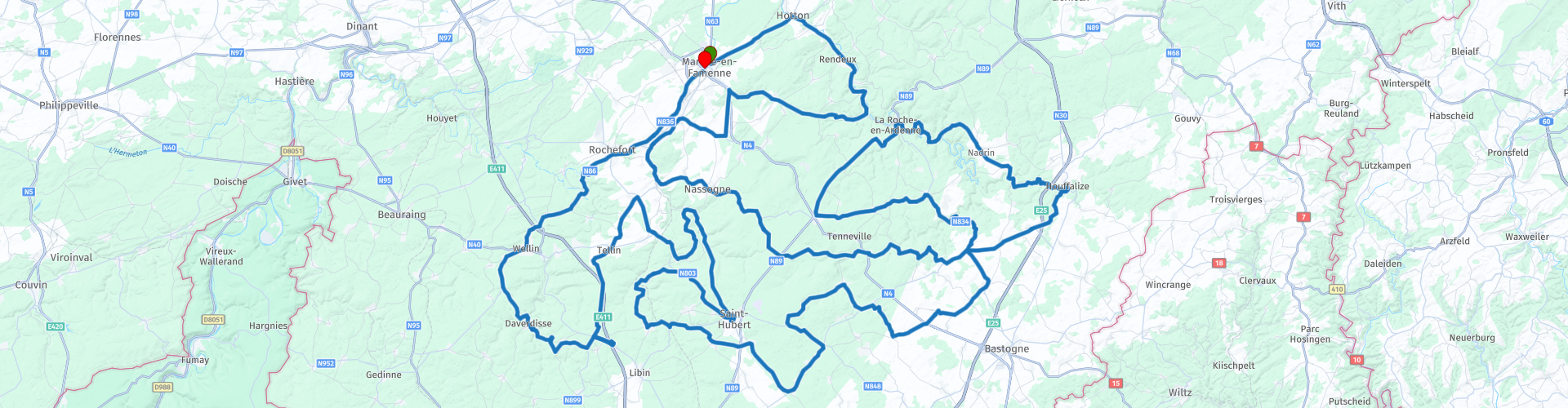
Roundtrip from Marche through the heart of the Ardennes

This route was brought to you by:
RouteXpert Catherine De Groote RouteXpert
Last edit: 01-05-2021
 Route Summary
 Wide, beautiful asphalt roads meander over the hills, often forced into a hairpin bend. But there are also numerous small roads through dense forests where no one drives. Culture and nature merge perfectly here. Monuments, castles, industrial heritage… you will encounter it all on this tour that deserves 5 stars.
 Share this route


Animation

Verdict


Duration
10h 22m

Mode of travel
Car or motorcycle

Distance
330.74 km

Countries

 RouteXpert Review
 You take towards Hotton, which is a well-known tourist attraction. The history of this place goes far in the past. This is evident from traces found in the cave of Porte Aïve. This is a prehistoric cemetery about 50 meters above the Isabelle valley. Hotton is known to many from the Battle of the Bulge. The municipality was therefore severely affected by the violence of the Second World War. The advance of the German army was halted here along the left bank of the Ourthe. A memorial stone can be found at the bridge.
For the next 10 km you keep following the Ourthe. Open spaces alternate with dense wooded strips.
In Nassogne, a small and cozy village, you will pass the Saint Mono Church. The choir is some 700 years older than the rest of the 17th century building. Here you can have a coffee stop at the Relais Saint-Monon.
You continue through the protected forest of Nassogne and enjoy the rural road, which does not immediately invite you to continue driving, because there is a lot of fine gravel on the road surface.
It is therefore unexpected that you suddenly cross a relatively busy dual carriageway that splits the forest in two. Coniferous trees alternate with deciduous trees. The Ourthe Valley beckons.
A row of sharp hairpin bends down and suddenly you are in the city center of La Roche, which is dominated by the castle ruins. It is a popular holiday resort.
There is a large parking lot at the Quai de L'Ourthe and you can walk to a large number of attractions. The American Tank and the Castle are within walking distance.
The tank is a tribute to the 2nd and 3rd Armored Divisions of the United States Army. It was these divisions that liberated La Roche-en-Ardenne in December 1944 during the Battle of the Bulge. The tank was unveiled on December 17, 2004, 60 years after the Battle of the Bulge.
From the main shopping street, Rue Chamont, of La Roche-en-Ardenne you turn into a side street and then it is quite a climb to the entrance of the castle. The castle was built between the 11th and 14th centuries and is made entirely of slate. The castle was inhabited until the end of the 18th century and then it was gutted by the inhabitants of the city. All usable parts were brutally demolished from the castle. It was not until the end of the 20th century that the tourist value of the Castle was recognized and a start was made to clear it and make it accessible. From the castle you have a magnificent view over La Roche-en-Ardenne and the river Ourthe.
Opening dates and hours: July and August: from 10 am to 6 pm - April, May, June, September, October: from 11 am to 5 pm - From November 9 to April: on weekdays from 1 pm to 4 pm / During weekends and Christmas and spring break from 11am to 4.30pm
Entrance fee: € 6.50 pp
In the tourist center of La Roche there are several restaurants and brasseries where you can relax on the terrace.
In Maboge you leave the meandering Ourthe. Beyond Nadrin you will pass the Europalia monument. The sculpture is made in pink marble from Portugal by the Portuguese artist João Charters de Almeida. The monument was inaugurated in 1991 by the wife of Portuguese President Mário Soares as part of Europalia Portugal. The work consists of a stylized portico in the shape of a dolmen, which symbolizes the openness of Europe. There are six pillars on both the left and right, representing the, at that time, twelve European member states. These columns refer to the menhirs, which are considered the oldest witnesses of European civilization.
From Houffalize it goes back to Saint-Hubert, along smaller roads. Here the forest has made way for arable farming.
The first texts referring to Laval Castle date from 1385. The building was destroyed in 1410. The 'Seigneurie' was partially rebuilt between 1532 and 1548. The coat of arms carved into the stone above the main entrance dates from that time. At the end of the 19th century, the residential wing was added, which today is called 'the Tower'. Now holiday homes have been created.
The closer you get to Saint-Hubert, the more conspicuous the forest takes over again. At the roundabout, take the first exit to the center of Saint-Hubert.
Saint Hubert is known as the 'capital of the real Ardennes' thanks to hunting. The city initially grew around the Saint-Hubert Chapel, but later the focus shifted to the Saint-Hubert Abbey. The Abbey of Saint-Hubert was a Benedictine monastery founded in the Ardennes in 687 and suppressed in 1797. The former abbey church is now a minor basilica in the diocese of Namur. It was listed as a heritage site in 1938 and as an exceptional monument in 2016. In front of the abbey church, there is the possibility to eat something in the Italian restaurant 'Il diablo'.
Now you return to the roundabout and take the second exit. You continue your way through the wooded provincial domain of Mirwart.
Fourneau Saint-Michel is a hamlet and open-air museum to the north of Saint-Hubert, between the wooded hills of the green valley of the river Masblette. Benedictine monks used to live in this valley. Fourneau Saint-Michel is an old ironworking center.
In the Domain Fourneau Saint-Michel, you can stroll along eight hamlets typical of rural architecture: houses, farms, a school, a chapel, etc. The iron museum is located on the site of a protected industrial monument. heritage, namely a unique blast furnace with charcoal. You will be guided through the history of this thriving industry in the 17th and 18th centuries through beautiful scenes and exceptional historical objects. You will discover the techniques and the daily use of iron.
OPENING HOURS: from 01/03/2019 to 30/11/2019: Tuesday-Sunday: 9.30am-5pm - from 01/07/2019 to 31/08/2019: Monday-Sunday: 9.30am-6pm - from 01/12/2019 until 28/02/2020: only accessible for walks.
Entrance price: € 5.00 pp.
In Tellin you can visit the old bell foundry. In this still intact unique foundry you can discover the work of the master founders, the art of the bell tower and the symbolism of the bells. The Causard-Slégers bell foundry started its activities in 1832 and experienced considerable commercial growth. Almost 13,000 bells have sunk. In the years 55 to 60, the foundry employed more than 35 workers. It ceased operations in 1970.
The foundry is open according to a schedule (see link below). All tours are guided. A visit includes the projection of a historical film recording in the active Tellin foundry (+/- 1/2 hour) followed by the tour of the old foundry (+/- 1 hour).
Entrance price: € 5.00 pp.
At the next roundabout after crossing the E411 you can deviate from the route for a visit to the Euro Space Center where you can learn everything about space travel.
The Euro Space Center was inaugurated in 1991. The center is modeled on the US Space Camp in Huntsville, Alabama, United States and uses the same advanced equipment and software as the real astronaut training at the Marshall Space Flight Center, also in Huntsville is located. In the meantime, the Euro Space Society has also been founded, which is chaired by astronaut Viscount Dirk Frimout. The society aims to interest a wide audience (and mainly young people) in space science and technology.
Entrance price: from € 12.00 to € 24.00 pp. according to the selected program.
After a possible visit you drive back to the roundabout.
Redu is internationally known as a book village. Many bookstores have been established in the village since 1984, mostly antique dealers and second-hand bookstores. The village with about 500 inhabitants attracts more than 300,000 visitors every year. Globally, it ranks second as a book village after Hay-on-Wye. You can take a break here for a drink in the Auberge Gourmande, chez Manu.
There is also an ESA tracking station on the territory of Redu. It is part of the ESA ground station network and home to the space weather data center - the Space Weather Data Center - which is part of ESA's Space Situational Awareness Preparatory Program.
The ground station has been operational since January 1, 1968 and covers a total area of 29,000 square meters. On an area of 3,000 square meters, there are, among other things, control centers, rooms with technical equipment and antenna bunkers. On the site there are 43 rotatable antennas that are operational in different frequency bands. The largest antennas are the Galileo IOT L band (a dish antenna with a diameter of 20 meters), the Estrack S band (15 meters) and the TMS-1M Ka band (13.5 meters).
The final runs towards Daverdisse and Wellin to the Domain of the Caves of Han, which is well worth a visit.
The reception hall of the domain is located in the center of the village opposite the church. The Safari car and the tram leave from this place to the domain.
Your PassHan ticket gives you access to: the Cave of Han, the Wildlife Park, the PrehistoHan, Han 1900.
It is valid all season. The various attractions of the Domain can be visited on different days: you can easily spend a day in the Wildlife Park and explore the Cave another time. The same goes for the PrehistoHan and Han 1900 museums.
Price online: € 29.90 pp.
Gradually the forests give way to rolling farmland and after a few kilometers you are back in Marche-en-Famenne. At restaurant Le Creta you can reminisce about this more than 300 km long ride with a nice meal.
In this region you come to enjoy a nature panorama. Wide, beautiful asphalt roads meander over the hills, often forced into a hairpin bend. But there are also numerous small roads through dense forests where no one drives. The disadvantage of these roads is that the road surface is sometimes not that good. Culture and nature merge perfectly here. Monuments, castles, industrial heritage… you will encounter it all on this tour that deserves 5 stars.


 Links
Links  Usage
Usage Want to download this route?
You can download the route for free without MyRoute-app account. To do so, open the route and click 'save as'. Want to edit this route?
No problem, start by opening the route. Follow the tutorial and create your personal MyRoute-app account. After registration, your trial starts automatically.  Disclaimer
Use of this GPS route is at your own expense and risk. The route has been carefully composed and checked by a MyRoute-app accredited RouteXpert for use on TomTom, Garmin and MyRoute-app Navigation.
Changes may nevertheless have occurred due to changed circumstances, road diversions or seasonal closures. We therefore recommend checking each route before use.
Preferably use the route track in your navigation system. More information about the use of MyRoute-app can be found on the website under 'Community' or 'Academy'.
;_vue_de_la_partie_occidentale_du_château-fort_(XIIIe–XIX_siècles).jpg/1280px-Bouillon_(Belgique);_vue_de_la_partie_occidentale_du_château-fort_(XIIIe–XIX_siècles).jpg)
Luxembourg
About this region
Luxembourg (French: Luxembourg [lyksɑ̃buʁ] (About this soundlisten); Dutch: Luxemburg [ˈlyksəmˌbʏrx] (About this soundlisten); German: Luxemburg [ˈlʊksəmbʊʁk] (About this soundlisten); Luxembourgish: Lëtzebuerg; Walloon: Lussimbork), also called Belgian Luxembourg, is the southernmost province of Wallonia and of Belgium. It borders on the country of Luxembourg to the east, the French departments of Ardennes, Meuse and Meurthe-et-Moselle to the south and southwest, and the Walloon provinces of Namur and Liège to the north. Its capital and largest city is Arlon (Luxembourgish: Arel, Dutch: Aarlen), in the south-east of the province.
It has an area of 4,459 km2 (1,722 sq mi), making it the largest Belgian province. With around 285,000 residents, it is also the least populated province, with a density of 64/km2 (170/sq mi), making it a relatively sparsely settled part of a very densely populated region.
It is significantly larger (70%), but much less populous than the neighbouring Grand Duchy of Luxembourg. About eighty percent of the province is part of the densely wooded Ardennes region. The southernmost region of the province is called Gaume or Belgian Lorraine (main city: Virton).
The Arelerland or Arlon region (in red on the map of arrondissements, below) bordering the neighbouring Grand-Duchy of Luxembourg has the particularity that many of its residents have historically spoken Luxembourgish, a language closely related to German, rather than the French or Walloon spoken elsewhere in the province.
The province was separated from the neighbouring Luxembourg by the Third Partition of Luxembourg, de jure in 1830–31 by the Conference of London dealing with the consequences of the Belgian Revolution of 1830, de facto in 1839, after William I, King of the Netherlands and Grand-Duke of Luxembourg, agreed to its decisions and thus the province was given to the newly created Kingdom of Belgium.
Read more on Wikipedia
It has an area of 4,459 km2 (1,722 sq mi), making it the largest Belgian province. With around 285,000 residents, it is also the least populated province, with a density of 64/km2 (170/sq mi), making it a relatively sparsely settled part of a very densely populated region.
It is significantly larger (70%), but much less populous than the neighbouring Grand Duchy of Luxembourg. About eighty percent of the province is part of the densely wooded Ardennes region. The southernmost region of the province is called Gaume or Belgian Lorraine (main city: Virton).
The Arelerland or Arlon region (in red on the map of arrondissements, below) bordering the neighbouring Grand-Duchy of Luxembourg has the particularity that many of its residents have historically spoken Luxembourgish, a language closely related to German, rather than the French or Walloon spoken elsewhere in the province.
The province was separated from the neighbouring Luxembourg by the Third Partition of Luxembourg, de jure in 1830–31 by the Conference of London dealing with the consequences of the Belgian Revolution of 1830, de facto in 1839, after William I, King of the Netherlands and Grand-Duke of Luxembourg, agreed to its decisions and thus the province was given to the newly created Kingdom of Belgium.
View region
 Statistics
  39
39Amount of RX reviews (Luxembourg )
 22658
22658Amount of visitors (Luxembourg )
 8245
8245Amount of downloads (Luxembourg )
 Route Collections in this region
 Route collection MRA NAVIGATION GRAND TOUR 2019
MRA NAVIGATION GRAND TOUR 2019 in short:
From 2019, MyRoute-app organizes every year the "MyRoute-app Navigation Grand Tour" exclusively for MyRoute-app Navigation users. During the Grand Tour you drive 4 routes during the calendar year. A few commands are included in each route. Participants who capture all 4 tracks via MyRoute-app Navigation have the chance to win a great prize. In 2019 we had chosen the 2nd World War as the theme for the 4 routes.
The routes and the assignments:
As mentioned, the theme of 2019 was the 2nd World War. A loaded theme, you are confronted with the dual nature of humanity; the willingness to kill for an ideology, we are better than them, cruelty, slaughter, but also heroism and sacrifices, would it ever change? I myself am very interested in world history, I have even studied it for a year at the university and certainly the 1st and 2nd world war have my interest. So it was no task to put together the routes, drive yourself and come up with the assignments.
Have fun driving these beautiful and interesting routes with a loaded theme!
View Route Collection
5 tours in Belgium in flat Flanders the hills of the Pays des Collines and the Ardennes
Those who like a winding and hilly course, along many small lanes with little to no traffic, will certainly find what they are looking for in the Pays des Collines, the region east and south of Ronse.
Between Diksmuide and Ypres there are many commemorative monuments of the First World War. In Vinkt in East Flanders, the monument commemorates the massacre that took place in May 1940.
Along rural quiet roads you can taste the history of World War I and II.
Marche-en-Famenne is an excellent starting point to thoroughly explore this plateau, which is cut by rivers and strewn with coniferous forests. The real Ardennes are the most hilly areas of Belgium behind the Meuse. Nature plays an all-important role on this trip.
In addition to the Ardennes, the route with start and end point in Huy also goes through a part of Condroz and Famenne. The Condroz, where wooded hills and valleys alternate, and the Famenne, which makes the transition to the Ardennes plateaus. In the summer it is wonderful motorcycling in the vast forests. You will not only enjoy the natural beauty, but you will also pass numerous castles, wild flowing Ardennes rivers, quiet villages and authentic tourist towns.
The tour from Namur runs through the Meuse area where you discover that the tributaries of the Meuse are of picturesque beauty. You will pass a large number of castles and fortresses. The roads along the Maas are busy arterial roads. But as soon as you can you will look for the smaller roads that are immediately a lot quieter and take us through forests and meadows.
View Route Collection