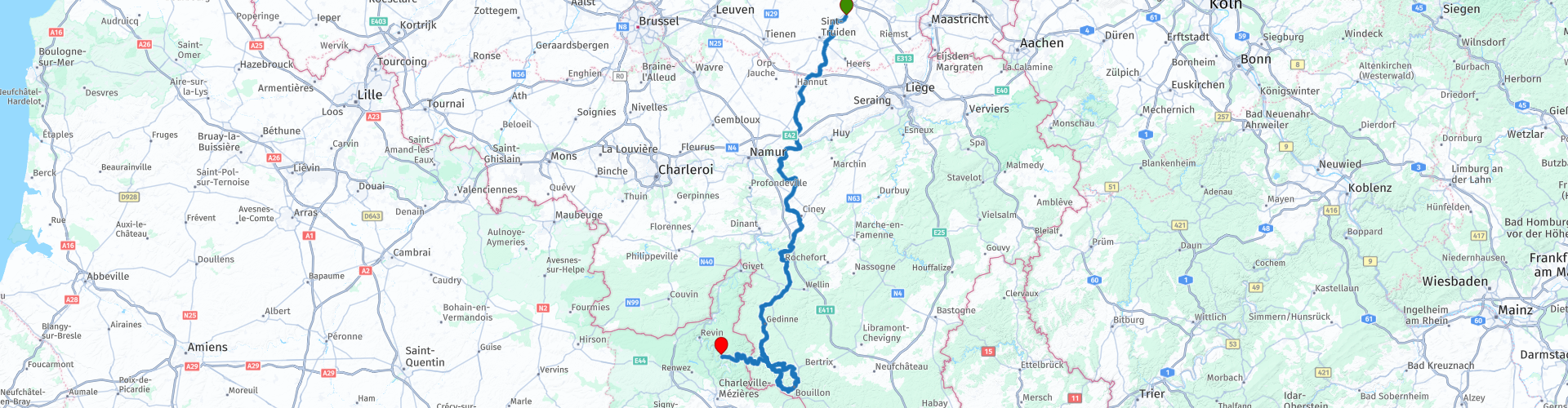
From Alken to the French Ardennes

This route was brought to you by:
RouteXpert Guy Heyns - Adv. RouteXpert
Last edit: 10-12-2024
 Route Summary
 It is a pleasant course that turns completely into a motorbike playground from route point 28.
Nice curves on excellent asphalt slide under your wheels in a loop while you are on your way through a very interesting and very beautiful area to Monthermé, a quiet French village where you can enjoy a good night's sleep.
Relaxing ride on which multiple types of motorcyclists can easily feel at home.
 Share this route


Animation

Verdict


Duration
5h 3m

Mode of travel
Car or motorcycle

Distance
251.45 km

Countries


 RouteXpert Review
 The departure (rp1) is in the center of Alken, the Limburg village that is very well known in Belgium for its brewery (marked on the map) and located near the departure point. You can easily park just in front of 'In de Ton', a local and cozy café with plenty of parking space in front and next to it.
Immediately after departure you dive into the country roads. Before you reach the first petrol station on your road (rp4 - 13 km), you should have a nice look around ... after all, this route takes you past several beautiful castles and just past rp 3 you have already passed the Castle of Ordingen (on your right side…).
We are not going to list all the castles along the route, but would like to draw your attention to the fact that you will encounter many nice things along this route, including some beautiful castles. Not all of them are equally well preserved and some of them are even dilapidated, but that is no less beautiful or interesting.
At route point 6 you leave Flanders and enter Wallonia. From here you are allowed - unless otherwise indicated - to drive 90 km / hour outside the center - good to know in any case… even if you return to Flanders. The Flemish road police will not hesitate to supplement your holiday album with a more expensive photo copy if you do not comply with the Flemish rules upon your return.
The route continues in a very relaxing and pleasant way towards route point 14, where you will encounter the Maas for the first time. Please feel free to take a look at the breadth of this lifeline and the industry that has been placed around it. You will also get to know the Maas further on this route, and a little higher upstream, in its 'natural' habitat.
Before that, however, we will first enjoy the Walloon roads and the playground that is yet to come….
At route point 17, we would like to draw your attention to the Castle of Faulx-les Tombes. Note… you are only going to see a flash of it at this waypoint and you must look carefully at the top right. But it is a beauty of a castle, unfortunately not to visit because it is privately owned.
Fun fact is that the village of Faulx-les-Tombes, which was built all the way around the castle, actually consists of two different villages (Faulx & Les Tombes), separated by a river called 'Samson' (what's in a name…).
The comfort that the road offers you allows you to dream away for a moment of any wealth and how - you too - can become lord of such an estate, but as long as the lottery shop is not nearby, it is best to drive on and stay enjoy the nice road that takes you further to Ciney at route point 20.
Ciney is known not only for the famous beer that bears her name, but also because Ciney is the capital of this Condroz region. By the way… the beer in question…. is brewed in ... Alken, the village where you left 100 kilometers ago ... Not only all Ciney beers are made there, but also a lot of other abbey beers ... Take a look at the bottom left where the Alken-Maes brewery is explained.
Historically, Ciney played a very important role in the wars between the County of Namur and the Principality of Liège. One of the most important wars was the 'Guerre de la Vache', which ruined the local atmosphere for three years between 1275 and 1278. The war started after a dispute over the sale of a cow on the market. The farmer, who was convicted of stealing the cow, was falsely executed by the 'other party' and the fire was lit for three years….
Today you can take a pleasant break in Ciney, because it is a pleasant village, although I can imagine that opening a beef steak restaurant may raise some questions here. Perhaps that is why you will find many pizzerias & pita tents ... No problem, therefore, to enjoy a short and tasty lunch here. And you can do that here. Further along the route, catering establishments are much scarcer ...
On the way to route point 27, where the curves playground starts, you will notice that the course is becoming more and more winding. Especially enjoy the beautiful surroundings through which you drive.
Just after route point 28 you will arrive on the loop placed in the route. Open all your senses and absorb the surroundings of Bouillon deep into you. Driving in this region is breathtakingly beautiful and varied. The roads are beautiful and they lead you through beautiful woods and forests. Keep in mind that the entire Ardennes area is a lavish hunting area where deer, wild boars and other large game are abundantly present. So be careful in the forest areas and adjust your speed, unless you unintentionally wish to thin out the wildlife stock.
Bouillon (rp33) is a small, but not unimportant city in this region. Godefroid de Bouillon, one of the most important leaders of the first Crusade, came from here. But also the great (?) Napoleon himself spent the night here shortly after his defeat against the Prussian army and just before his surrender. So, historically, bouillon has contributed quite a bit.
But also geologically, Bouillon is interesting and the region attracts a lot of tourists, purely because of its beauty and pure nature, which the river Semois is not foreign to. Bouillon is also literally surrounded by a large meander of this Semois that forms the 'The tomb of the giant'. The name came about because the trees on this peninsula in winter more or less form a large cross on the island.
The rest of the route takes place all the way along the banks of the Semois, you meander, along with the river, into France at route point 39. You then follow the Semois all the way until it surrenders in the arms of the Meuse, the river where you sleep along in hotel 'Les Boucles de Meuse' in Monthermé, the end point of this route.
The route from Alken to Monthermé is very fun, pleasant to ride, surprising and versatile and offers all types of riders a special atmospheric stay on excellent road surfaces. The area is breathtakingly beautiful and extremely varied as you drive 'through mountain and valley' to your destination - Monthermé. Not only because of all these characteristics, but also because of the historical value of the region around Bouillon, we give this route a five-star rating and we are not alone here. Michelin's maps also indicate a great many beautiful and 'green' roads with which they want to draw the attention of all kinds of drivers to the special road quality and beauty in and of this region. Enjoy it!


 Links
Links  Usage
Usage Want to download this route?
You can download the route for free without MyRoute-app account. To do so, open the route and click 'save as'. Want to edit this route?
No problem, start by opening the route. Follow the tutorial and create your personal MyRoute-app account. After registration, your trial starts automatically.  Disclaimer
Use of this GPS route is at your own expense and risk. The route has been carefully composed and checked by a MyRoute-app accredited RouteXpert for use on TomTom, Garmin and MyRoute-app Navigation.
Changes may nevertheless have occurred due to changed circumstances, road diversions or seasonal closures. We therefore recommend checking each route before use.
Preferably use the route track in your navigation system. More information about the use of MyRoute-app can be found on the website under 'Community' or 'Academy'.

Wallonia
About this region
The Walloon Region (French: Région wallonne [ʁeʒjɔ̃ walɔn]; German: Wallonische Region; Dutch: Waals gewest), usually simply referred to as Wallonia (; French: Wallonie [walɔni]; Walloon: Waloneye; German: Wallonien [vaˈloːni̯ən] (listen) or Wallonie [valoˈniː]; Dutch: Wallonië [ʋɑˈloːnijə] (listen)), is one of the three Regions of Belgium—alongside the Flemish Region and the Brussels-Capital Region.Covering the southern portion of the country, Wallonia is primarily French-speaking, and accounts for 55% of Belgium's territory, but only a third of its population. The Walloon Region was not merged with the French Community of Belgium, which is the political entity responsible for matters related mainly to culture and education, because the French Community of Belgium encompasses both Wallonia and the bilingual Brussels-Capital Region.
There is a German-speaking minority in eastern Wallonia, resulting from the annexation of three cantons previously part of the German Empire at the conclusion of World War I. This community represents less than 1% of the Belgian population. It forms the German-speaking Community of Belgium, which has its own government and parliament for culture-related issues.
During the industrial revolution, Wallonia was second only to the United Kingdom in industrialization, capitalizing on its extensive deposits of coal and iron. This brought the region wealth, and from the beginning of the 19th to the middle of the 20th century, Wallonia was the more prosperous half of Belgium. Since World War II, the importance of heavy industry has greatly diminished, and the Flemish Region has exceeded Wallonia in wealth as Wallonia has declined economically. Wallonia now suffers from high unemployment and has a significantly lower GDP per capita than Flanders. The economic inequalities and linguistic divide between the two are major sources of political conflicts in Belgium and a major factor in Flemish separatism.
The capital of Wallonia is Namur, and the most populous city is Charleroi. Most of Wallonia's major cities and two-thirds of its population lie along the east-west aligned Sambre and Meuse valley, the former industrial backbone of Belgium. To the north of this valley, Wallonia lies on the Central Belgian Plateau, which, like Flanders, is a relatively flat and agriculturally fertile area. The south and southeast of Wallonia is made up of the Ardennes, an expanse of forested highland that is less densely populated.
Wallonia borders Flanders and the Netherlands (the province of Limburg) in the north, France (Grand Est and Hauts-de-France) to the south and west, and Germany (North Rhine-Westphalia and Rhineland-Palatinate) and Luxembourg (Capellen, Clervaux, Esch-sur-Alzette, Redange and Wiltz) to the east. Wallonia has been a member of the Organisation Internationale de la Francophonie since 1980.
Read more on Wikipedia
There is a German-speaking minority in eastern Wallonia, resulting from the annexation of three cantons previously part of the German Empire at the conclusion of World War I. This community represents less than 1% of the Belgian population. It forms the German-speaking Community of Belgium, which has its own government and parliament for culture-related issues.
During the industrial revolution, Wallonia was second only to the United Kingdom in industrialization, capitalizing on its extensive deposits of coal and iron. This brought the region wealth, and from the beginning of the 19th to the middle of the 20th century, Wallonia was the more prosperous half of Belgium. Since World War II, the importance of heavy industry has greatly diminished, and the Flemish Region has exceeded Wallonia in wealth as Wallonia has declined economically. Wallonia now suffers from high unemployment and has a significantly lower GDP per capita than Flanders. The economic inequalities and linguistic divide between the two are major sources of political conflicts in Belgium and a major factor in Flemish separatism.
The capital of Wallonia is Namur, and the most populous city is Charleroi. Most of Wallonia's major cities and two-thirds of its population lie along the east-west aligned Sambre and Meuse valley, the former industrial backbone of Belgium. To the north of this valley, Wallonia lies on the Central Belgian Plateau, which, like Flanders, is a relatively flat and agriculturally fertile area. The south and southeast of Wallonia is made up of the Ardennes, an expanse of forested highland that is less densely populated.
Wallonia borders Flanders and the Netherlands (the province of Limburg) in the north, France (Grand Est and Hauts-de-France) to the south and west, and Germany (North Rhine-Westphalia and Rhineland-Palatinate) and Luxembourg (Capellen, Clervaux, Esch-sur-Alzette, Redange and Wiltz) to the east. Wallonia has been a member of the Organisation Internationale de la Francophonie since 1980.
View region
 Statistics
  96
96Amount of RX reviews (Wallonia)
 26714
26714Amount of visitors (Wallonia)
 21543
21543Amount of downloads (Wallonia)
 Route Collections in this region
 The 10 most beautiful car and motorcycle routes in Limburg
Limburg, who thinks of Limburg, thinks of flan, coal mines, marl and the hill country. The coal mines have been closed for almost 40 years, the last load of coal was brought up from the Oranje-Nassau coal mine in Heerlen on 31 December and, as they say, South Limburg was transformed from Black to Green and unfortunately there is still little left. view of this period.
But not only pie, marl and coal in Limburg, but also a very beautiful province to tour by car or motorcycle and enjoy all the beauty that the province of Limburg has to offer. For this, the MyRoute app RouteXpert has put together a Top 10 of Car and Motorcycle routes for you.
All routes in this collection have been checked and made equal for TomTom, Garmin and MyRoute-app Navigation by a MyRoute-app RouteXpert.
If you think, I have a very nice route that should certainly not be missing from this collection, send it to:
email: routeexpert@myrouteapp.com
Subject: New Route for the Top 10 collection Province of Limburg composed by Hans van de Ven.
The route will then be reviewed and then added to the Top 10.
To make the Top 10 also the Top 10, 1 route will have to disappear from the Top 10, you can indicate this when submitting the new route.
Have fun with this collection and while driving one of these routes. Enjoy all the beauty that the Netherlands and in particular the province of Limburg has to offer. Click on “View route” to read the review of the chosen route.
I would like to hear your findings about the route(s).
View Route Collection
Top 5 Car and Motorcycle Routes in the Eifel
The Eifel is the eastern part of the medium plateau Eifel-Ardennes. It is located north of the Moselle and west of the Rhine. The largest part is in Germany, a small part is in Belgium, in the East Cantons. The German part of Eifel is located in the federal states of North Rhine-Westphalia and Rhineland-Palatinate. The highest point is the Hohe Acht with 747 meters.
Several chains can be distinguished in the Eifel:
The northernmost part is called the Nordeifel, which in Belgium connects to the High Fens;
To the east of this is the Ahrgebirge, this part is located north of the Ahr in the Ahrweiler district;
South of the Ahr is the Hohe Eifel (or Hocheifel), of which the Hohe Acht (747 m) is the highest point, and also the highest point in the entire Eifel region;
To the west, near the Belgian border, the hills are known as Schneifel, part of the wider Snow Eifel area with peaks reaching up to 698 metres;
South and east of the Hohe Eifel is the Volcano-Eifel, a volcanic area with many crater lakes (Maare).
The southern part of the Eifel is less high. The area is bisected by streams and rivers running southwards. These streams flow into the Moselle. The largest of these rivers is the Kyll; the hills around this river are known as the Kyllwald;
In the south, the Eifel ends in the Voreifel.
In the north of the Eifel there are some large reservoirs. The largest of these is the reservoir in the Roer that was created by the construction of the Roerdal dam.
The Nürburgring is also located in the Eifel, a well-known car circuit for Formula 1 races, among other things. Since 2004, part of the north of the Eifel has become the Eifel National Park. This National Park falls entirely within the German-Belgian nature park High Fens-Eifel. Another part of the Eifel falls within the South Eifel Nature Park.
Well-known throughout the Netherlands and Belgium by car and motorcyclists, so reason enough for the MyRoute app RouteXpert to compile a Top 5 of Car and Motorbike routes for you.
All routes in this collection have been checked and made equal for TomTom, Garmin and MyRoute-app Navigation by a MyRoute-app RouteXpert.
If you think, I have a very nice route that should certainly not be missing from this collection, send it to:
email: routeexpert@myrouteapp.com
Subject: New Route for the Top 5 collection Eifel composed by Hans van de Ven.
The route will then be reviewed and then added to the Top 5. To make the Top 5 also the Top 5, 1 route will have to disappear from the Top 5, you can indicate this when submitting the new route.
Have fun with this collection and while driving one of these routes. Enjoy all the beauty that the Eifel has to offer. Click on “View route” to read the review of the chosen route.
I would like to hear your findings about the route(s).
View Route Collection