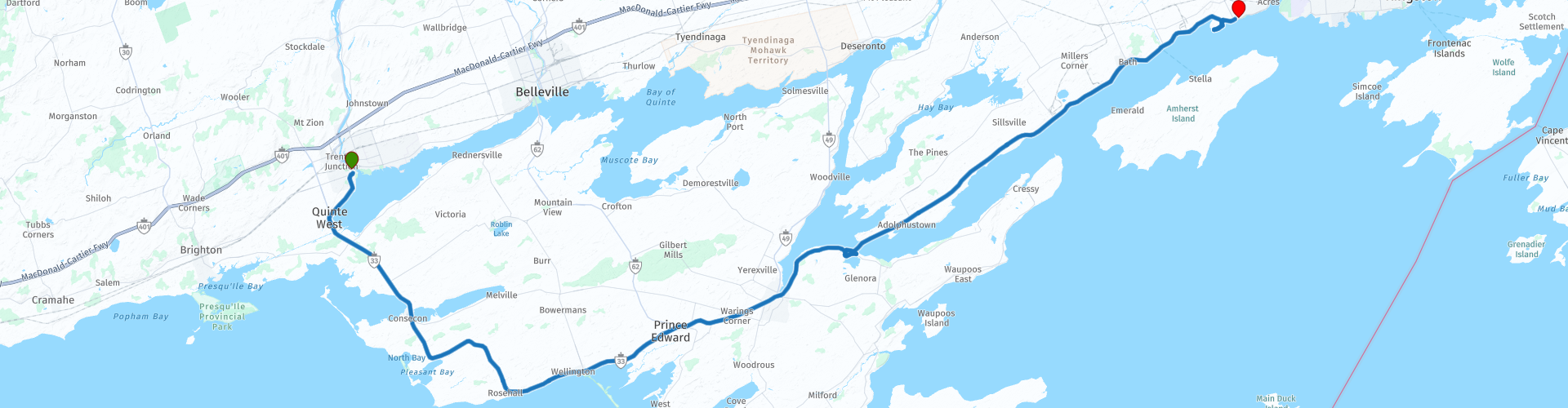
Loyalist Parkway from Trenton to Amherstview

This route was brought to you by:
RouteXpert William Edward Henry
Last edit: 07-11-2021
 Route Summary
 Due to its historic role in early colonisation and its prime scenic location, the original route from Kingston westward through Bath and the Quinte Region is commemorated as the Loyalist Parkway.
The United Empire Loyalists were of different racial and religious backgrounds but were united by their loyalty to the Crown. They fled the United States following the American War of Independence in the late 1700’s, and were granted parcels of land to settle by King George III of Britain. Many of their descendants still live and work in the region.
The Eastern entrance to the Parkway is marked by impressive gates that Her Majesty Queen Elizabeth II officially dedicated in 1984. The Western entrance, at the roundabout intersection with County Road 40 in Quinte West, is highlighted by a sign featuring the Parkway's logo, surrounded by foliage provided and maintained by the Loyalist Parkway Association.
Between the east and west gates there are more than three dozen commemorative plaques describing historical attractions and events including the family home of Canada's first Prime Minister, Sir John A. MacDonald.
Among the many attractions available to the traveler today are parks and parkettes in the communities of Carrying Place, Ameliasburgh, Hillier, Wellington, Picton, Glenora, Adolphustown, Lennox Power Station and Bath, including roadside parks along the Lakeshore and at the Eastern Gates at the Fairfield-White House.
This route makes a small diversion from the Parkway to visit the Lake on the Mountain Provincial Park.
After visiting the Lake, we take the ferry ride between Glenora to Adolphustown with its splendid views, free of charge.
I give this route a three-star rating. The roads are not challenging, but the scenery is beautiful and the historical context is of great interest. The short ferry ride across Adolphus Reach is a fun diversion. It's a nice route for a lazy ride along a scenic historic road.
 Share this route


Animation

Verdict


Duration
4h 7m

Mode of travel
Car or motorcycle

Distance
106.96 km

Countries

 RouteXpert Review
 Following the American Revolution of 1776 to 1783, individuals who had supported Britain or had wished to remain neutral on religious and ethical grounds were persecuted, deprived of their property, and often their lives. Survivors fled to areas of British protection around the globe. Those who had fought alongside the British as Loyalist Regiments joined the exodus.
The first legal British settlement in Canada other than military establishments took place in what was then western Quebec and is now eastern Ontario. The settlers were made up of soldiers from Loyalist Regiments, e.g., the Kings Royal Regiment of New York and Jessup's Rangers, European (Hessian) troops in British service, and civilians. Many were from lower New York State and the Mohawk Valley. Their numbers included many Mohawk Indians.
These early settlers suffered terribly from cold, starvation and disease but persevered to become major participants in the formation of Ontario and ultimately Canada.
The Loyalist Parkway is a commemoration of their loyalty and determination. They founded what would become the Canadian province of Ontario.
Heading south-south-east (SSE) on Highway 33, we pass the west entrance of the Loyalist Parkway and proceed to the swing bridge over the Murray Canal. There is a small parking lot here if you want to stop for a photograph of the bridge and vessels transiting the canal.
Continuing on SSE, we pass through the small town of Carrying Place and into a rural landscape punctuated with open fields. Some are under cultivation with an abundant crop of corn (maize) while others lie uncultivated and fallow. In addition to farm houses, there is the occasional residential stretch with houses set back from the road on well-kept properties.
As you approach the outskirts of the town of Consecon, you will catch glimpses of Wellers Bay off to the right through gaps in the trees which line the road. Take care when approaching Consecon and other small towns on this route. The speed limit drops suddenly and is enforced. The road into the town of Consecon branches off to the right, but you will remain on the Loyalist Parkway and not pass through the centre of town itself.
After Consecon, you will be in rural countryside again now given over to vinyards and their associated wineries. You will pass several of these, e.g., Harwood Estate Winery, Hillier Creek Winery, Stanners Vinyard, and Sandbanks Winery, over the next several miles with each offering tasting samples of their libations. It seems that the farmers find it more profitable to grow grapes than corn.
On your way to the town of Wellington, you will have a good view of the expanse of Lake Ontario off to the right. Wellington is a pleasant town with a main street offering numerous cafes, restaurants, and ice cream parlors. On Saturdays, a farmers' market will cause much congestion and pedestrian traffic.
Leaving Wellington behind, you will have an easy ride through the countryside and a few other small towns, e.g., Bloomfield, on you way to the large town of Picton. Along the way, you will encounter the first provincial roundabout (traffic circle) constructed in Ontario. At the roundabout is the Waring House which boasts an inn, restaurant, conference centre, and cooking school.
The town of Picton is blessed with a good harbour located at the head of Picton Bay. The town is large enough to offer hazardous traffic and a comprehensive suite of amenities including pharmacies, banks, restuarants, inns, craft brewery, liquor store, and a hospital. Of particular note is the Picton Harbour Inn and its associated Lighthouse Restaurant. Both are reputed to be excellent.
After leaving Picton, our next stop is the Lake on the Mountain. This remarkable feature is a small lake located about 200 feet above the level of Lake Ontario. It's a nice spot to stop for a break. There is a small parking lot, public toilets, and picnic tables.
A short distance from the Lake on the Mountain is the Glenora Ferry. This free service runs frequently and offers a pleasant ride across the waters of Adolphus Reach (Lake Ontario) from Prince Edward County to the mainland.
After exiting the ferry, you will have a relaxed run along the shore of Lake Ontario to the eastern gates of the Parkway. There is parking and a small park (Fairfield Park) there to relax and contemplate your return ride. If you are pressed for time, the major east-west Highway 401 is a short distance away or a more leisurely return ride along the Loyalist Parkway beckons.


 Links
Links  Usage
Usage Want to download this route?
You can download the route for free without MyRoute-app account. To do so, open the route and click 'save as'. Want to edit this route?
No problem, start by opening the route. Follow the tutorial and create your personal MyRoute-app account. After registration, your trial starts automatically.  Disclaimer
Use of this GPS route is at your own expense and risk. The route has been carefully composed and checked by a MyRoute-app accredited RouteXpert for use on TomTom, Garmin and MyRoute-app Navigation.
Changes may nevertheless have occurred due to changed circumstances, road diversions or seasonal closures. We therefore recommend checking each route before use.
Preferably use the route track in your navigation system. More information about the use of MyRoute-app can be found on the website under 'Community' or 'Academy'.

Ontario
About this region
Ontario ( (listen) on-TAIR-ee-oh; French: [ɔ̃taʁjo]) is one of the thirteen provinces and territories of Canada. Located in Central Canada, it is Canada's most populous province, with 38.3 percent of the country's population, and is the second-largest province by total area (after Quebec). Ontario is Canada's fourth-largest jurisdiction in total area when the territories of the Northwest Territories and Nunavut are included. It is home to the nation's capital city, Ottawa, and the nation's most populous city, Toronto, which is also Ontario's provincial capital.
Ontario is bordered by the province of Manitoba to the west, Hudson Bay and James Bay to the north, and Quebec to the east and northeast, and to the south by the U.S. states of (from west to east) Minnesota, Michigan, Ohio, Pennsylvania, and New York. Almost all of Ontario's 2,700 km (1,678 mi) border with the United States follows inland waterways: from the westerly Lake of the Woods, eastward along the major rivers and lakes of the Great Lakes/Saint Lawrence River drainage system. These include Rainy River, Pigeon River, Lake Superior, St. Marys River, Lake Huron, St. Clair River, Lake St. Clair, Detroit River, Lake Erie, Niagara River, Lake Ontario and the St. Lawrence River from Kingston, to the Quebec boundary just east of Cornwall. There is only about 1 km (0.6 mi) of land border, made up of portages including Height of Land Portage on the Minnesota border.Ontario is sometimes conceptually divided into two regions, Northern Ontario and Southern Ontario. The great majority of Ontario's population and arable land is in the south. In contrast, the larger, northern part of Ontario is sparsely populated with cold winters and heavy forestation.
Read more on Wikipedia
Ontario is bordered by the province of Manitoba to the west, Hudson Bay and James Bay to the north, and Quebec to the east and northeast, and to the south by the U.S. states of (from west to east) Minnesota, Michigan, Ohio, Pennsylvania, and New York. Almost all of Ontario's 2,700 km (1,678 mi) border with the United States follows inland waterways: from the westerly Lake of the Woods, eastward along the major rivers and lakes of the Great Lakes/Saint Lawrence River drainage system. These include Rainy River, Pigeon River, Lake Superior, St. Marys River, Lake Huron, St. Clair River, Lake St. Clair, Detroit River, Lake Erie, Niagara River, Lake Ontario and the St. Lawrence River from Kingston, to the Quebec boundary just east of Cornwall. There is only about 1 km (0.6 mi) of land border, made up of portages including Height of Land Portage on the Minnesota border.Ontario is sometimes conceptually divided into two regions, Northern Ontario and Southern Ontario. The great majority of Ontario's population and arable land is in the south. In contrast, the larger, northern part of Ontario is sparsely populated with cold winters and heavy forestation.
View region
 Statistics
  18
18Amount of RX reviews (Ontario)
 11001
11001Amount of visitors (Ontario)
 550
550Amount of downloads (Ontario)
 Route Collections in this region
 The ultimate Great Lakes Tour
This is a tour from Chicago to Staten Island, New York visiting the 5 Great Lakes of North America.
Starting from EagleRider Motorcycle rental at Illinois Harley-Davidson in Chicago and ending at EagleRider Motorcycle rental in Staten Island.
The Ultimate Great Lakes tour is a route through the United States and Canada to scenic destinations along Lakes Michigan, Superior, Huron, Erie and Ontario.
What are the Great Lakes? The Great Lakes are a series of five interconnected freshwater lakes located on the border of the United States and Canada. They are the largest group of freshwater lakes in the world by area and have sea-like characteristics such as rolling waves, strong currents, miles of sandy and rocky beaches, and distant horizons. This tour of 8 routes includes places to stop for coffee, lunch and overnight hotels. It also visits well known historic and scenic sites along the way mostly avoiding major highways. I have suggested 2 nights at Lake Superior and 2 nights at Niagara Falls, making this a 10 day tour, but of course, that is up to you. The scenery and landscapes are breathtaking and each day is different to the next. Please enjoy.
View Route Collection
Trans Canada Highway
The Trans-Canada Highway (TCH) or Trans-Canadian Highway is a system of highways that cover all 10 provinces of Canada.
The Federal and Provincial Highways System that now forms the TCH were authorized by the Trans-Canada Highway Act of 1948 and opened in 1962. It was completed in 1971. The total length of the TCH is 7821 km.
Contrary to the American Interstate Highway System, the TCH does not consist of an unambiguous network of motorways, but forms a network of restricted access highways and other main routes that are more akin to the Dutch provincial roads. The route is indicated by a green shield with a white maple leaf.
The numbering of the roads that are part of the TCH is the domain of the provinces. Only the western provinces have aligned their numbering and the TCH has the designation Highway 1 there.
The main route of the TCH starts in Victoria in British Columbia and runs via Calgary and Regina to Winnipeg. From Winnipeg the route leads to Kenora in Ontario, after which several branches pass through Ontario to Ottawa.
Further east, the route passes through the province of Quebec via Montreal and Quebec, among others, to Moncton, New Brunswick. Then the TCH continues east through Nova Scotia, where a branch (via the Confederation Bridge) leads to Prince Edward Island. Another section runs down to the sea in the port city of Sydney, where a ferry service leaves for Channel-Port aux Basques on the island of Newfoundland. From there the route continues for more than 900 km to the provincial capital of St. John's, in the extreme southeast of the island.
We not only drive the TCH, but will take the rural roads as much as possible, because only Highway driving is too boring and Canada has many beautiful roads through its beautiful landscape. You drive through all provinces and through very varied and scenic landscapes, from the Rockies in the West, the Central Prairies to the Eastern Maritimes and the Northern Forest.
The riding season is generally April through October with longer seasons on the west coast and southern Ontario. Provide good all season clothing or bring rain gear, depending on the province and the season the weather can change and you may be surprised by a rain or even a snow or hail shower, so be prepared.
In Canada the metric system is used, so speeds are indicated in Km / h. A helmet requirement (DOT approved) applies throughout Canada.
You will see many wildlife throughout Canada. This varies from province to province, such as deer, buffalos, moose, caribou, wolves, pumas, bears, mountain goats, sheep, lynx, coyotes, foxes, raccoons, badgers, various rodents and all kinds of birds. Even if it is very tempting to stop for a photo, don't do it, it can be very dangerous.
The routes described in this review sometimes deviate from the Trans Canada Highway, bringing the total length to 9,300 kilometers. The routes are made so that you drive through the beautiful parts of Canada with truly beautiful panoramas and beautiful sights to visit, this differs from museums, parks to historical points. The routes are not too long so there is time to stop for photos and sights along the way. You can also choose to arrange and combine the stages differently or to add other routes to shorten or extend your journey. The routes are marked with a rating in stars, some routes are less challenging or interesting but are necessary to drive to the next point, which is why they often have a lower rating.
In the route description you will find more details about the routes and the points of interest along the way. These points and also hotels, restaurants, petrol stations etc. are indicated with a POI and sometimes also with a Route point. In the description you will also find links to interesting sites and to the routes that connect to that day.
The described routes are;
Day 01 TCH Victory to Nanaimo
Day 02 TCH Nanaimo to Hope
Day 03 TCH Hope to Kamloops
Day 04 TCH Kamloops to Revelstoke
Day 05 TCH Revelstoke to Lake Louise
Day 06 TCH Lake Louise to Calgary
Day 07 TCH Calgary to Medicine Hat
Day 08 TCH Medicine Hat to Moose Jaw
Day 09 TCH Moose Jaw to Regina
Day 10 TCH Regina to Brandon
Day 11 TCH Brandon to Winnipeg
Day 12 TCH Winnipeg to Kenora
Day 13 TCH Kenora to Ignace
Day 14 TCH Ignace to Thunder Bay
Day 15 TCH Thunder Bay to Marathon
Day 16 Thunder Bay to Wawa
Day 17 TCH Wawa to Sault Ste Marie
Day 18 TCH Sault Ste Marie to Espanola
Day 19 TCH Espanola to Mattawa
Day 20 TCH Mattawa to Ottawa
Day 21 TCH Ottawa to Montreal
Day 22 TCH Montreal to Quebec
Day 23 TCH Quebec to Riviere du Loup
Day 24 TCH Riviere du Loup to Grand Falls
Day 25 TCH Grand Falls to Fredericton
Day 26 TCH Fredericton to Moncton
Day 27 TCH Moncton to Charlottetown
Day 28 TCH Charlottetown to Truro
Day 29 TCH Truro to North Sydney
Day 30 TCH North Sydney to Corner Brook
Day 31 TCH Corner Brook to Grand Falls
Day 32 TCH Grand Falls to Clarenville
Day 33 TCH Clarenville to St John.
Have fun reading the reviews and planning your next road trip.
If you have driven this trip, I am very curious about your feedback!
View Route Collection