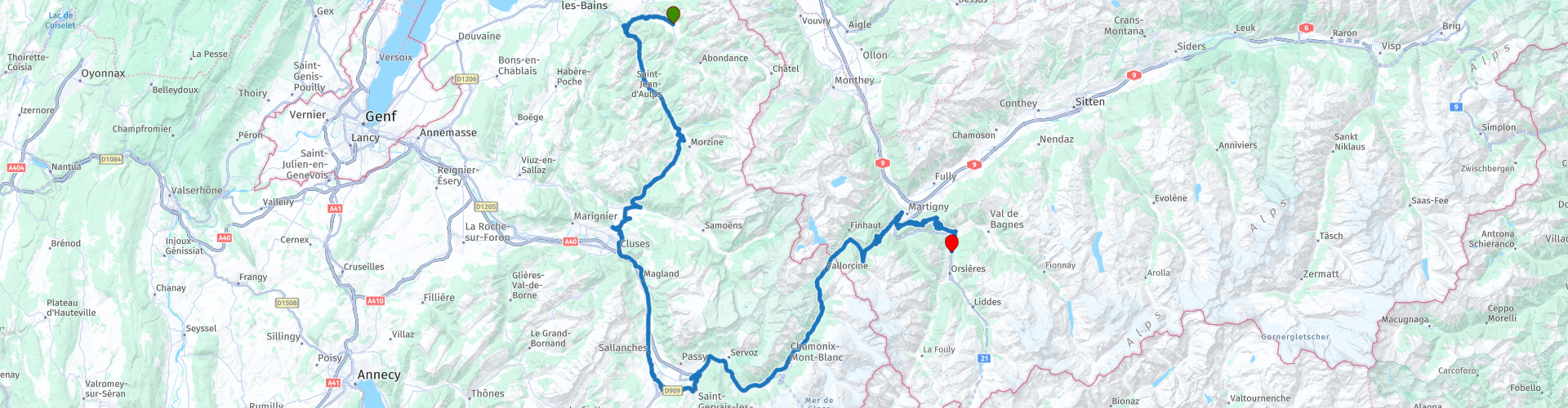
Across country borders 02 Vacheresse to Orsieres along the Mont Blanc massif

This route was brought to you by:
RouteXpert Catherine De Groote RouteXpert
Last edit: 11-03-2024
 Route Summary
 No less impressive are the individual towns and villages you drive through. BulIe, in the heart of the Gruyère district, and Cluses, in the Arve Valley in the French Alps, are as historic as they are picturesque. This also applies to Monthey, the city on the Vièze. In between, in touristy Saanen and in Gstaad, the typical chalet architecture surprises: it belongs to Switzerland, just like skyscrapers belong to New York.
A true highlight among the Alpine passes is the Pas de Morgins, which connects Switzerland with France. The Col de la Forclaz - between the Rhone Valley and Chamonix - is also an important transport link. Chamonix is famous as the location of the first Winter Olympics in 1924. On the Swiss side you mainly see vineyards, in France dense green forests dominate the landscape. The mighty, usually snow-capped Mont-Blanc is almost always in sight. At the Col du Grand Saint-Bernard (Great St. Bernard Pass), take the road over the pass: you cannot miss the beauty of this border area between Switzerland and Italy.
This route in the border area of France and Switzerland promises many beautiful things. The gorges of the Gorges du Point du Diable in the Vallée d'Aulps are impressive. Hairpin bends and majestic views are part of the Col de La Forclaz and Col des Planches. But the highlight of this ride is the Mont-Blanc massif in the Chamonix area. With the highest point at 4,810 meters, it is the perfect place to admire the fantastic landscapes of the high mountains, with glaciers, mountain peaks and snow-capped peaks. Giving the ride less than 5 stars is therefore not an option.
 Share this route


Animation

Verdict


Duration
8h 16m

Mode of travel
Car or motorcycle

Distance
171.05 km

Countries


 RouteXpert Review
 Past Bioge, ignore the Route des Grands Alpes and choose the narrower road with some serious hairpin bends.
The Gorges du Pont du Diable are located in the Vallée d'Aulps, in the beautiful UNESCO nature reserve 'Chablais'. These are impressive gorges through which the Dranse river flows. At the top of the gorge is the Pont du Diable, the 'Devil's Bridge'. To get to the entrance of the gorge, you have to take a walk of about 20 minutes through a beech forest and along rocks. When you arrive at the gorge you will see the Dranse River flowing about 50 m below.
The gorges were under a glacier far in the past. The meltwater caused erosion in the limestone subsurface. Holes in the rock walls can be seen throughout the gorge. These are created by eddies. The erosion caused cracks to widen, causing at one point a large boulder fell into the gorge and got stuck halfway. This is called the devil's bridge. Under this rock and 50m above the water of the Dranse River, a glass floor has now been created where you can stand and look straight down. Bridges and walkways have been constructed throughout much of the gorge. In total, the height difference during the walk through the gorge is approximately 120m. At the end you will return to the path that takes you back to the beginning.
The Abbey of Aulps was founded at the end of the 11th century. The monks joined the Cistercian order in 1136. It became one of the most important monasteries in medieval Savoy. Most of the buildings were destroyed in 1823. Until 1998 the monastery estate was a farm.
The domain of the Aulps Abbey has an area of three hectares and is located at an altitude of 800 meters. It contains the remains of the abbey church, the cellars, the gardens, the gatehouse and especially the former monastery farm. The abbey's gardens have also received special attention, with the creation of a botanical garden (herbularius) and a vegetable garden (hortus). The Sainte-Marie d'Aulps Abbey is a true architectural treasure trove.
Via a few S-bends and the Col des Gets it goes to the tourist towns of Cluses in the Vallée de I'Arve. It is surrounded by beautiful nature and has been known for its watchmaking craft since the 18th century. In addition, more than 200 companies are located here that produce turning parts, such as screws, spindles or bolts.
You stay away from the highway and take the parallel road with beautiful views of the surrounding mountains.
Restaurant Le Four in St Gervais les Bains guarantees a pleasant and friendly environment. On sunny days you can enjoy the shaded terrace in a rural setting by the river. The local dishes are fantastic and at very good prices.
You are now just a stone's throw away from Chamonix.
This old mountaineering village - at an altitude of 1030 m at the foot of Mont-Blanc - is today a mix of grand hotels and campsites, casinos and fast food chains. Something like this is probably only conceivable in France. The town has a great name among mountain climbers: alpinists from all over the world come together in 'Cham'. It is said that on the streets of this 'high mountain city' you can hear all the languages of the world. As the site of the First Winter Olympics in 1924, the village established its world fame as a winter sports mecca. The decisive factor here is not found in the valley, but high above Chamonix. The best overview of this beautiful area is provided from the 2524 m high Brévent, which is accessible by cable car. Here you can also take the cable car to the Aiguille du Midi. Breathtaking views of the French, Swiss and Italian Alps await you. From the top terrace (3842 m) you can enjoy an unforgettable view of Mont Blanc.
The Col des Montets is a 1461 meter high mountain pass that, together with the Col de la Forclaz, forms the connection between the French Chamonix-Mont-Blanc and the Swiss Valais. To the west of the pass rise the Aiguilles Rouges (2965 m), to the south there is a good view of the Mont Blanc massif. Usually the section of the pass road is open to traffic all year round. However, in winter the road may be closed due to avalanche danger.
The D1506 passes small villages and through unlit tunnels. It is an important connection between France and Switzerland. Here and there the road is narrow and/or not very good. So adjust your driving behavior accordingly. Shortly after the Swiss municipality of Trient, the route surprises with the first narrow hairpin bend and a beautiful view over the Mont Blanc massif in the southeast. Then you continue up to the Col de la Forclaz (1527 m). On the east side, extensive vineyards determine the landscape and you descend to the beautiful Valais town of Martigny.
Celtic tribes, the Romans and Napoleon's troops have left their mark on Martigny. You can admire a restored amphitheater, as well as Roman baths, temples and residential areas. Later this place became the first episcopal see in Switzerland, which can now be seen in the historic districts of La Batiaz and Vieux-Bourg. In the past, personalities such as Rousseau, Goethe and Liszt lived in this 'Valaiser Sonnenstad'.
The first kilometers of the climb to the Col des Planches from the town of Martigny are steep. The road bends from the start of the climb and the gradient, with sections of more than 15%, never decreases until you reach Chemin-Dessous, the first village you pass. A hairpin bend allows you to enjoy the impressive view of the bend in the Rhône and the town of Martigny below. Then the slope becomes gentler and you can discover the Combe de la Forclaz as you climb through larch forests. The top of the Col des Planches is at 1410 m.
In the descent to Sembrancher you will encounter a few hairpin bends. Don't forget to enjoy the surrounding landscape and steep rock walls.
You have reached the end of this route in Orsières. The gite-restaurant Le Catogne is a place where life is good. The typical character of the place will delight you with its rustic soul of wood, stone, Swiss chalet and warm atmosphere. You will be welcomed in a friendly atmosphere in both the restaurant and the Gîte. There are ten rooms available and you can choose between half board or breakfast. The rooms are equipped with a shower, toilet, TV, free WiFi and a view of the Dranse.
In the restaurant you can discover regional products: Assiette Valaisanne, Pavé de Boeuf sur pierre Ollaire, Tartare de Boeuf, or be tempted by cheese dishes: raclette, fondue... Le Catogne has a spacious parking lot.


 Links
Links  Usage
Usage Want to download this route?
You can download the route for free without MyRoute-app account. To do so, open the route and click 'save as'. Want to edit this route?
No problem, start by opening the route. Follow the tutorial and create your personal MyRoute-app account. After registration, your trial starts automatically.  Disclaimer
Use of this GPS route is at your own expense and risk. The route has been carefully composed and checked by a MyRoute-app accredited RouteXpert for use on TomTom, Garmin and MyRoute-app Navigation.
Changes may nevertheless have occurred due to changed circumstances, road diversions or seasonal closures. We therefore recommend checking each route before use.
Preferably use the route track in your navigation system. More information about the use of MyRoute-app can be found on the website under 'Community' or 'Academy'.

Auvergne Rhone Alpes
About this region
Auvergne-Rhône-Alpes (ARA; French: [ovɛʁɲ ʁon‿alp] (listen); Arpitan: Ôvèrgne-Rôno-Ârpes; Occitan: Auvèrnhe Ròse Aups; Italian: Alvernia-Rodano-Alpi) is a region in southeast-central France created by the 2014 territorial reform of French regions; it resulted from the merger of Auvergne and Rhône-Alpes. The new region came into effect on 1 January 2016, after the regional elections in December 2015.The region covers an area of 69,711 km2 (26,916 sq mi), making it the third largest in metropolitan France; it had a population of 7,948,287 in 2017, second to Île-de-France. It consists of twelve departments and one territorial collectivity (Lyon Metropolis) with Lyon as the prefecture.
This new region combines diverse geographical, sociological, economic and cultural regions, which was already true of Rhône-Alpes, as well as Auvergne, to a lesser extent. While the old Rhône-Alpes and Auvergne regions each enjoyed a unity defined by axes of communication and the pull of their respective metropoles, the new combination is heterogeneous; it sustained lively opposition from some local officials after its creation.
Read more on Wikipedia
This new region combines diverse geographical, sociological, economic and cultural regions, which was already true of Rhône-Alpes, as well as Auvergne, to a lesser extent. While the old Rhône-Alpes and Auvergne regions each enjoyed a unity defined by axes of communication and the pull of their respective metropoles, the new combination is heterogeneous; it sustained lively opposition from some local officials after its creation.
View region
 Statistics
  119
119Amount of RX reviews (Auvergne Rhone Alpes)
 45156
45156Amount of visitors (Auvergne Rhone Alpes)
 5433
5433Amount of downloads (Auvergne Rhone Alpes)
 Route Collections in this region
 The 24 Most Beautiful Alpine Routes
The Alps, The Alps are a mountain range in Europe, stretching from the French Mediterranean coast in the southwest to the Pannonian Plain in the east. The area of the mountain range is more than 200,000 km².
In other words Passes and Mountain Roads!
Driving through the mountains is great! Especially over the mountain passes with hairpin bends and narrow winding roads. Every bend a different view where you can enjoy. There are many beautiful mountain passes in the Alps.
A selection that has also been incorporated into these routes:
The Stlevio Pass:
The Stelvio Pass, also known as Passo dello Stelvio, is mainly known for the stage in the Giro d'Italia. Due to the length and the difference in height, this pass is seen as one of the toughest tests in cycling. The Stelvio Pass reaches a maximum height of 2758 meters and is therefore one of the highest in the Alps. The pass connects the towns of Bormio and Prato Allo Stelvio. In winter the pass is closed due to heavy snowfall.
The Reschenpass:
The Reschenpass, also known as Passo di Resia, connects the Austrian state of Tyrol with the Italian province of South Tyrol. The pass reaches a maximum height of 1,504 meters and has been one of the most important north-south connections in the Alps in recent centuries. The pass was used long before Roman times. Along the way you will pass several highlights and historical relics. One of the highlights is the Reschensee. This lake was created after the construction of the dam and has completely submerged the village of Graun. The only thing that reminds of that is the clock tower in the middle of the lake.
Col du Galibier:
The French mountain pass Col du Galibier connects the towns of Saint-Michel-de-Maurienne and Briançon via the Col du Lautaret in the south and the Col du Télégraphe in the north. The mountain pass is part of the Tour de France and very much feared, due to the fact that it can only be reached via the other two mountain passes. The pass reaches a maximum height of 2646 meters. From there you can take a walk to the viewpoint at 2704 meters. You can admire the peaks of the Grand Galibier, Mont Blanc and La Meije here.
The Grossglockner High Alpine Road:
With a height of 3798 meters the Grossglockner is the highest mountain in Austria. To fully enjoy this impressive mountain, you can drive over the Grossglockner High Alpine Road and the accompanying pass. The route starts from Bruck am Grossglockner and ends in Heiligenblut. Of course you can drive in two directions. The pass reaches a maximum height of 2504 meters and is closed in winter due to heavy snowfall. Along the way you pass several stops with fun activities, information points, mountain huts and viewpoints. A visit to the Kaiser-Franz-Josefs-Höhe and Pasterzen Glacier is highly recommended.
The Col d'Izoard:
Just like the Col du Galibier, the Col d'Izoard is also part of a stage of the Tour de France. The mountain pass connects Briançon with the valley of the river Guil. The pass is partly located in the Regional Natural Park du Queyras and reaches a maximum height of 2360 meters. What is special about the Col d'Izoard is the barren and rocky landscape. Sometimes it feels like driving a car over the moon! Along the way you can stop at several points to enjoy the beautiful view.
The Bernina Pass:
The Bernina Express is one of the most famous rail trains in Switzerland and the Alps. The route is beautiful and partly included on the UNESCO World Heritage List. Parallel to the railway lies the Bernina pass, which connects the Veltlin valley with the Egandin valley. This beautiful Alpine road has a total length of 56 kilometers and reaches a maximum height of 2328 meters. Along the way you can enjoy views of the Morteratsch Glacier.
The Sella Pass:
The Sella Pass, also known as Passo di Sella, takes you over one of the most impressive mountain ranges in the Dolomites: the Sella massif. The pass connects Valle di Fassa with Val Gardena and reaches a maximum height of 2236 meters. At this height is also the border of the Italian provinces of Trentino and Bolzano. Along the way you can enjoy the view of this spectacular mountain world. Admire, for example, the three peaks of the Sasso Lungo massif, the Sella massif or the peaks of the Marmolada. You can also drive the Sella pass in combination with the Gardena pass, Pordoi pass and Campolongo pass.
The Grimsel Pass:
The Grimsel Pass connects Goms in Wallis with the Halis Valley in the Bernese Oberland. The pass reaches a maximum elevation of 2165 meters and is closed in winter due to snowfall. Over the centuries, the mountain pass has played an important role in trade between Switzerland and Italy. Now it is mainly the reservoirs that have an important function. These are used to generate electricity. The landscape you drive through is rugged, rocky and impressive. On top of the pass is a hotel and a restaurant with a special marmot park. The Dodensee (Totensee) is also located here. This lake owes its name to the many soldiers who died in the time of Napoleon.
The Gotthard Pass:
The Gotthard Pass, also known as Passo del San Gottardo and Saint Gotthard, connects the Swiss towns of Airolo and Andermatt. The mountain pass and associated tunnel are especially known among holidaymakers driving from Switzerland to Italy. But where the majority opt for the tunnel, it is precisely the pass that really completes the holiday. The Gotthard Pass has a length of about 26 kilometers and reaches a maximum height of 2106 meters. The route is beautiful and takes you along old villages and beautiful views.
The Silvretta High Alpine Road and Silvretta Pass:
The Paznaun Valley in Tyrol and the Montafon in Vorarlberg are connected by the Silvretta High Alpine Road. The route has a length of 22.3 kilometers and leads from Galtür to Partenen in 34 hairpin bends, via the 2032 meter high Bielerhöhe. The Silvrettasee is also located at this point, where you can enjoy a lovely walk. The pass is closed in winter due to snowfall.
The Simplon Pass:
Just like the Gotthard Pass, many holidaymakers also travel over the Simplon Pass every year. This mountain pass connects the Rhone Valley in the canton of Valais with the Valle d'Ossola in Piemonte. The pass is open all year round and reaches a maximum height of 2005 meters. Along the way you pass a number of buildings, including the well-known Simplon Hospiz from 1825. The hospiz is managed by the monks of St. Bernard. From the highest point on the pass, all kinds of hiking routes are possible and you will also come across a hotel where you can spend the night.
The Gerlos Pass:
The Gerlos Pass connects the Salzach Valley in the Salzburgerland with the Zillertal Valley in Tyrol. The pass is part of the Gerlos Alpenstraße and runs right through the Hohe Tauern National Park. Along the way you can enjoy beautiful views of the surroundings. The pass has a length of 12 kilometers and reaches a maximum height of 1531 meters. A ride over the Gerlos Pass can be ideally combined with a visit to the Krimmler Wasserfälle.
The Great St. Bernard Pass:
The Great St. Bernard Pass, better known as Col du Grand Saint Bernard, connects the Italian province of Valle d'Aosta with the Swiss canton of Valais. The pass is one of the highest in Switzerland and reaches a maximum height of 2469 meters. Like a number of other mountain passes in this list, the Great St. Bernard Pass has also been used as a connecting road for centuries. The pass is named after the St. Bernard dogs that used to help stranded travelers along with the monks. The pass is closed in winter.
The Timmelsjoch High Alpine Road:
The Timmelsjoch High Alpine Road connects the towns of Sölden in the Ötztal and Meran in South Tyrol. Tolls must be paid on the Hochgurgl - Moos route. Via a mountain road with about 60 hairpin bends you drive through a beautiful mountain world. With the Timmelsjoch Experience you can learn more about the history, the road and the environment via various stations. You can also visit the Top Mountain Crosspoint museum.
Col de l'Iseran:
With a maximum pass height of 2770 meters, the Col l'Iséran is one of the highest mountain passes in the Alps. The pass connects Bourg-Saint-Maurice with Bonneval-sur-Arc. Via a road full of hairpin bends you pass, among other things, Val-d'Isère and a side valley of the Maurienne that lies entirely in the National Park de la Vanoise. You can spot animals such as marmots and chamois and there is also a restaurant with a chapel on top of the pass.
The Gavia Pass:
The Gavia Pass (Italian Passo di Gavia) is a mountain pass in the Italian Alps, in the Lombardy region.
It is one of the highest pass roads in Europe. The road leads through the unspoilt Stelvio National Park. The road was built in the First World War to supply Italian soldiers who fought in the Italian-Austrian border area. The pass height is one of the most beautiful in the Alps. Here is the large Lago Bianco with, to the north, the mountain San Matteo (3684 meters). Lago Nero is slightly lower on the south side of the pass. Here the mountain group of the Adamello determines the view. There are many well-marked walks in the area. During the winter the pass is closed due to the heavy snowfall. The pass is often closed until May and June due to the large amount of snow.
Promoter has made a selection of the 24 Most Beautiful Alpine routes that they have set out in recent years.
The routes go through:
France
Austria
Switzerland
Italy
The most beautiful roads, the most beautiful views, the most beautiful viewpoints. The highest mountains, the fastest descents, hairpin bend after hairpin bend, you name it you can't get enough of it.
If you go on holiday in this region, take advantage of it, ALL routes in this collection have been checked and made equal for TomTom, Garmin and MyRoute-app Navigation by a MyRoute-app RouteXpert.
Have fun with this collection and while driving one of these routes. Enjoy all the beauty that the Alps and the Dolomites have to offer. Click on “View route” to read the review of the chosen route.
I would like to hear your findings about the route(s).
View Route Collection
25 Magnificent trails in France
This MRA route collection contains 25 beautiful motorcycle routes in different parts of France, such as the Ardennes, the Alsace, Vercors, the Drôme, the Ardèche, Cote d'Azure, Gorges du Verdon, the Ariège, the Dordogne and Brittany.
The routes have been carefully created by Bert Loorbach, who is an enthusiastic motorcyclist himself. He lived in France for a year and a half, during which time he devoted himself to mapping the unknown and beautiful back roads of France especially for motorcyclists.
The routes are bundled in the Motortourgids France part 1 of Kosmos publishing house and now also available in MyRouteApp.
I have taken over the routes in MRA and sometimes adjusted them slightly to make them even more interesting for the motorcyclist.
View Route Collection