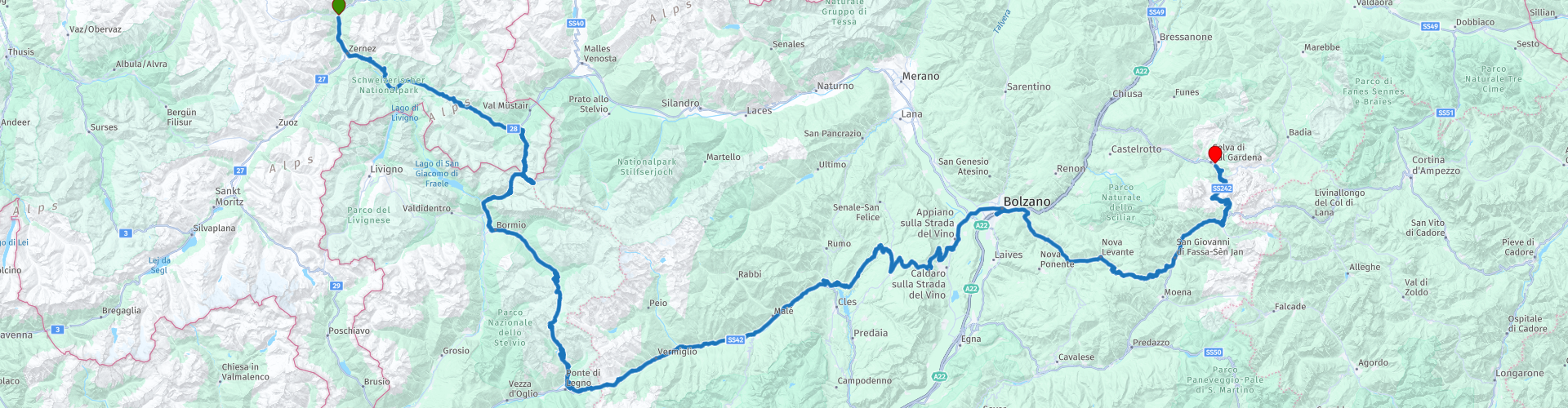
R05 Susch to Selva di Val Gardena

This route was brought to you by:
RouteXpert Arno van Lochem - Senior RX
Last edit: 20-09-2022
 Route Summary
 In this route you will encounter a few 'big boys'. First the Ofenpass, followed by the last pass in Switzerland, the Umbrailpass. This leads to the Stelvio Pass. You turn left to the top. At the top, turn around and drive back to Bormio, where you will go up the Gavia pass. After the Gavia pass you drive over the Passo del Tonale, the Mendel pass, the Passo di Costalunga and the Sella pass to eventually end at Hotel Antares in Selva di Val Gardena. Without perhaps noticing it, you have entered the beautiful world of the Dolomites...
Because of the beautiful passes, the great roads and all the beauty that can be seen along the way, this route deserves 5 stars.
Given the distances in mountainous areas and the many hairpin bends that can be very narrow at times, this route is suitable for the more advanced motorcyclist.
 Share this route


Animation

Verdict


Duration
0h 0m

Mode of travel
Car or motorcycle

Distance
0.00 km

Countries


 RouteXpert Review
 The route starts in Susch, again you can refuel shortly after the start if necessary. Once you have left the village, meander south along the Inn, in Zernez turn left onto the Ofen Pass. The Ofen Pass (Rhaeto-Roman: Pass dal Fuorn) is located in the east of the Swiss canton of Graubünden and forms the connection between the Engadin valley and the Val Müstair.
The Swiss National Park is located on the western side for a large part of the pass. From Zernez the broad road ascends moderately through the uninhabited valley of the river Spöl. At Punt la Drossa the road branches off to the right for the Munt la Schera tunnel (narrow and 3.4 km long), which forms the connection with the Italian Livigno. The road continues up through the Arven woods of the National Park. Two kilometers before the pass height is the Hotel Parc Nazional, which was once an iron smelter.
The mountain saddle of the Ofen Pass is below the tree line. At the highest point is the mountain hotel Süson Givè; the view from here on the Val Müstair is good. The Ofen Pass is a starting point for hikes. The descent is easy on the right road and after six kilometers the first village of Tschierv is reached. A little further on, the route starts to another pass: the Umbrail pass.
In Santa Maria you actually turn right onto the Umbrail pass. The Umbrail Pass (Italian: Giogo di Sta. Maria / alternative German name: Wormserjoch) is a mountain pass that lies on the border of Italy and Switzerland in the Stelvio National Park.
At the highest point an altitude of 2503m is indicated, where however the official height is 2501m, due to corrections to the altitude determination by the Swiss authorities. The pass height is not far from the 250 meters higher Stelvio pass, the Umbrail pass even leads to the Stelvio. In earlier times, the Umbrail Pass formed the connection between the Val Venosta (Vinschau) and the Valtellina. The current road was built in 1901. Due to heavy snowfall at the pass height, the road over the Umbrail is closed to traffic from October to May each year.
The ascent through the Val Muranzina leads with 34 hairpin bends through almost uninhabited area. The maximum gradient on this side is 14%. Until 2015, the road was not paved for several hundred meters halfway through, but this caused few problems.
At the top of the Umbrail you cross the border with Italy, a few tens of meters further you arrive at the Stelvio. You can go in two directions here, the route keeps left and goes to the top of the Stelvio Pass at 2758 meters. You can choose to keep to the right, but then you will miss one of the highlights of this trip. On top of the Stelvio Pass it is always very busy, many shops and stalls, restaurants and not forgetting the sausage sellers. A Bruno sausage is actually a must when you're here. :-)
The Passo dello Stelvio (German: Stilfserjoch) is a mountain pass located at an altitude of 2758 meters in the Italian Alps. The mountain pass is best known for cycling stages in the Tour of Italy. The Stelvio Pass is one of the highest paved mountain passes in the Alps; among others the Col de l'Iséran (Fra) is higher. The Col de la Bonette (Fra) is lower but because there is an extra loop at the top of the col, it is considered by some to be higher.
The Stelvio Pass is located on the border of the Italian-speaking province of Sondrio and German-speaking South Tyrol. East of the pass are the Ortler Alps with the highest point being the Ortler and even closer the Monte Livrio where the glaciers are skied during the summer season. To the north is the Dreisprachenspitze, the meeting point of three languages: Italian, German and Romansh. Finally, in the south, Monte Scorluzzo is one of the easiest to climb three-thousanders. The pass is located in the heart of the Stelvio National Park, one of the oldest (1936) and largest national parks in Europe.
At the beginning of the 19th century, Ferdinand I of Austria wanted to build a road that directly connected Val Venosta to Milan, which was then under Austrian rule. The road had to run over the mountain saddle northwest of the Ortler. Engineer Carlo Donegani from Sondrio, who had already built the Splügen Pass, was given the task of shaping the road. Construction started in 1822. The road was completed just three years later. Until 1915, the Stelvio Pass was ridden by carriages all year round. During the winter the road was kept passable by snow shovels. In 2019, however, the pass is closed to traffic from the end of October to the beginning of May. During the First World War, heavy fighting took place on the pass between the Italian and Austrian armies. From 1918, both sides of the pass height were Italian. The Stelvio Pass was no longer the important connection Milan-Vienna and was closed in winter just like the other high passes. After the Second World War, Giuseppe Pirovano of the Club Alpino Italiano established a ski school here and it was possible to ski on the vast glaciers in summer. In 2019 there are several large hotels at the pass height and several ski lifts go further into the mountains. The ATM of the Banco Popolare di Sondrio has the honor of being the highest ATM in Europe.
When you have finished eating you can continue the route by driving down again on the side where you came up, towards Bormio. This is a really beautiful descent with beautiful views. After you have reached the point where you have entered the Stelvio Pass, you have three more hairpin bends before you get a kind of plateau. Then a whole series of hairpin bends and a handful of tunnels. Tip: Watch out with sunglasses in these tunnels, because you won't see a hand in front of your eyes if you suddenly drive into the dark.
At the end of the descent you drive into Bormio, here you turn sharply left to drive towards the next pass, the Gaviapass. This is also one of the higher pass roads in Europe. The road leads right through the unspoilt Stelvio National Park. The road was built in the First World War to supply Italian soldiers who fought in the Italian-Austrian border area. The pass is one of the most beautiful in the Alps. Here lies the large Lago Bianco with, to the north, the mountain San Matteo (3684 meters). Lago Nero is slightly lower on the south side of the pass. Here the mountain group of the Adamello determines the view. There are many well-marked walks in the area. During the winter the pass is closed due to the heavy snowfall. The pass is often closed until May and June due to the large amount of snow.
The road section between Ponte di Legno and the pass height is very narrow, often no wider than three metres. Overtaking is almost impossible on the route, fall-back places have been constructed for this. Deep in the valley flows the river Frigidolfo. Along the deep precipices there is a guardrail in most places, but in some places it is missing. There begins the abyss of more than 500 meters deep next to the road. This makes this road one of the most dangerous mountain passes so beware! The side of Santa Caterina Valfurva is slightly wider and shorter.
After the descent, in Ponte Di Legno, turn left onto the SS42. You are immediately treated to a number of hairpin bends, or the next pass presents itself: Passo del Tonale. The Tonale Pass is a mountain pass on the border between the Italian regions of Lombardy and Trentino-Alto Adige. It is the connection between Ponte di Legno in the Val Camonica and Vermiglio in the Val di Sole. The Tonalepas can be ridden all year round. The pass height is a popular winter sports area in winter with over 100 kilometers of slopes. In summer it is a popular starting point for mountain hikers. South of the pass height rises the 3326 meter high La Presanella. During the ski season you can ski on the glaciers of this mountain.
During the First World War, the pass formed the border between Italy and Austria-Hungary and there was heavy fighting. A reminder of this is the war memorial west of the summit. A few kilometers away you can see at Forte Strino that there was a lot of fighting here in the First World War.
From the Passo del Tonale, keep following the SS42 until you reach Bolzano. On the way you pass the Mendel Pass, where it is high time for lunch. The Mendel Pass (Italian: Passo della Mendola) connects the Cles in the Valle di Non and Appiano sulla Strada del Vino in South Tyrol. The saddle is located between the Monte Penegal (1737 m) and the Monte Roen.
The SS42 runs over the mountain pass, starting in Lombardy Treviglio and ending in the town of Bolzano. The road over the Mendel Pass was built from 1880 to 1885. In the early twentieth century, the pass was a renowned holiday resort. Some famous persons who stayed there during this period are Franz Joseph I of Austria, Wilhelm Röntgen, Mahatma Gandhi and Elisabeth of Austria-Hungary.
When the weather is clear, the pass height offers a view of the Dolomites in the northeast. Some mountain formations that are clearly visible are Latemar, Rosengarten and Schlern.
After lunch you follow the SS42 as mentioned until Bolzano. There you drive over a traffic circle, it looks like spaghetti with all those roads that criss-cross over and under each other. Fortunately, the route you follow is not too difficult to follow, although you do have to pay attention. Then you drive a (boring) part through Bolzano, luckily this is not too long.
You soon turn off to the SS241, which takes you to the Passo di Costalunga. The Costalunga Pass (Italian: Passo di Costalunga / German: Karerpass / Ladin: Pas de Mont) is located on the border of the Italian provinces of Trento and South Tyrol. It is also the Italian-German language border, in the area east of the pass even a third language is spoken: Ladin. The Costalunga pass is open all year round. Together with the Pordoi Pass and Falzarego Pass, the Costalunga Pass forms the Dolomites Road.
The route to the pass from the west begins at Kardaun (Cardano) in the wide valley of the River Eisack (Isarco). Here the Valle d'Ega (Eggental) opens up, which forms a gorge in the first part. After a few kilometers the valley widens. The good road climbs through dense forests and villages in Tyrolean architecture up to the Lago di Carezza. The water has a clear blue-green color with dense coniferous forests in the background, above which the towers of the Latemar tower.
Just after the lake is Carezza al Lago. This place is an important tourist resort with large hotels, a golf course and a mountain railway to the Rifugio Paolina at 2126 meters altitude. At Carezza al Lago, the road branches off on the right to the Nigra Pass, which runs along the west flank of the Rosengarten massif. The pass height of the Costalunga is about three kilometers further. Here, the view of the southern flank of the Rosengarten and the distant Marmolada is good.
In Canazei you pass the last gas station in this route. Unfortunately there is no gas station in Selva di Val Gardena. So if you have run out of fuel, you have the option to fill the tank again.
The last pass in this route presents itself, the Sella pass. The Sella Pass (Italian: Passo di Sella, German: Sellajoch) forms the connection between the Val di Fassa and the Val Gardena (Gherdëina, Gröden) in Italy. The pass height also crosses the border between the Italian provinces of Trento and South Tyrol. The pass is often ridden in combination with the Pordoi pass, Campolongo pass and Gardena pass, which also surround the mighty mountain range of the Sella.
Canazei in the Valle di Fassa is the starting point on the south side. It is an important winter sports resort with the necessary ski and cabin lifts. From the center the road first climbs through the woods to Alp Roa, where the road branches off to the Pordoi Pass. The walls of the Sella massif rise vertically here. From this point it is another 5 kilometers to the top of the Sella Pass. The road is and remains good. The vegetation becomes thinner and stops near the height of the stride. Hotel Maria Flora is located almost at the highest point of the passage at 2244 meters.
The pass is located on a narrow mountain ridge. The view of the Val di Fassa and the Marmolada with its glacier is good, but it is the three peaks of the Sasso Lungo that attract the most attention. Various hiking tours depart from the pass height.
The descent to the Val Gardena is just as easy as on the other side. After 6 kilometers, branch off on the right-hand side towards the Gardena Pass. The road continues straight on to Selva di Val Gardena, which, like Canazei, is an important winter sports resort.
The end point is at Hotel Antares in Selva di Val Gardena. A nice hotel with swimming pool and sauna. From experience I can tell that the local pizza hut 50 meters away serves a great pizza. Diagonally across the street from the hotel is a good beer available on the terrace. The breakfast in the hotel is top class. Wide choice and very tasty.
Have fun driving this route!


 Links
Links  Usage
Usage Want to download this route?
You can download the route for free without MyRoute-app account. To do so, open the route and click 'save as'. Want to edit this route?
No problem, start by opening the route. Follow the tutorial and create your personal MyRoute-app account. After registration, your trial starts automatically.  Disclaimer
Use of this GPS route is at your own expense and risk. The route has been carefully composed and checked by a MyRoute-app accredited RouteXpert for use on TomTom, Garmin and MyRoute-app Navigation.
Changes may nevertheless have occurred due to changed circumstances, road diversions or seasonal closures. We therefore recommend checking each route before use.
Preferably use the route track in your navigation system. More information about the use of MyRoute-app can be found on the website under 'Community' or 'Academy'.

Graubunden
About this region
The Grisons or Graubünden, more formally the canton of the Grisons or the canton of Graubünden, is one of the twenty-six cantons of Switzerland. It has eleven regions, and its capital is Chur. The German name of the canton, Graubünden, translates as the "Grey Leagues", referring to the canton's origin in three local alliances, the Three Leagues. The other native names (Grischun in Rumantsch Grischun, Grisun in Lombard, and Grigioni in Italian) also refer to the Grey League. The Alpine ibex is the canton's heraldic symbol.
The largest and easternmost canton of Switzerland, it is also one of the three large southern Alpine cantons, along with Valais and Ticino. It is the most diverse canton in term of natural and cultural geography, as it encompasses both sides of the Alps and several natural and cultural regions. The diversity of the canton is often compared to that of Switzerland as a whole and warrants it the name of "Little Switzerland". The Grisons is bordered by four cantons: Ticino to the south; Uri to the west; and Glarus and St. Gallen to the north. The canton is also bordered by Liechtenstein to the north; Austria's federated states of Vorarlberg and Tyrol to the north and east; and Italy's autonomous province of South Tyrol and region of Lombardy to the south.
The Grisons is the only trilingual canton of Switzerland. It is also the only one where Romansh, Switzerland's fourth national language, has official status. Romansh language and culture is an important part of local identity. In 2020 the canton had a population of 200,096. It is the least densely populated canton of Switzerland. The only sizable city in the canton is Chur, as the majority of the population lives in mountainous areas, including some of the deepest valleys in Europe. The canton is a major tourist destination year-round, particularly for winter sports, and comprehends a large number of Alpine resort towns, notably Davos and St. Moritz. The canton is also renowned for its extensive narrow-gauge railway network, operated by the Rhaetian Railway.
Formerly occupied by the Rhaeti, most of the lands of the canton became once part of a Roman province called Raetia, which was established in 15 BC, with Curia, a settlement dating back to the Pfyn culture, as capital city. The area later became part of the lands of the diocese of Chur. The late middle ages saw the foundation of the League of God's House, the Grey League and the League of the Ten Jurisdictions. In 1471, an alliance gave birth to the Three Leagues, and before the end of the 15th century, the latter became an ally of the Old Swiss Confederacy. In 1803, the Three Leagues finally became one of the cantons of the Confederation.
Read more on Wikipedia
The largest and easternmost canton of Switzerland, it is also one of the three large southern Alpine cantons, along with Valais and Ticino. It is the most diverse canton in term of natural and cultural geography, as it encompasses both sides of the Alps and several natural and cultural regions. The diversity of the canton is often compared to that of Switzerland as a whole and warrants it the name of "Little Switzerland". The Grisons is bordered by four cantons: Ticino to the south; Uri to the west; and Glarus and St. Gallen to the north. The canton is also bordered by Liechtenstein to the north; Austria's federated states of Vorarlberg and Tyrol to the north and east; and Italy's autonomous province of South Tyrol and region of Lombardy to the south.
The Grisons is the only trilingual canton of Switzerland. It is also the only one where Romansh, Switzerland's fourth national language, has official status. Romansh language and culture is an important part of local identity. In 2020 the canton had a population of 200,096. It is the least densely populated canton of Switzerland. The only sizable city in the canton is Chur, as the majority of the population lives in mountainous areas, including some of the deepest valleys in Europe. The canton is a major tourist destination year-round, particularly for winter sports, and comprehends a large number of Alpine resort towns, notably Davos and St. Moritz. The canton is also renowned for its extensive narrow-gauge railway network, operated by the Rhaetian Railway.
Formerly occupied by the Rhaeti, most of the lands of the canton became once part of a Roman province called Raetia, which was established in 15 BC, with Curia, a settlement dating back to the Pfyn culture, as capital city. The area later became part of the lands of the diocese of Chur. The late middle ages saw the foundation of the League of God's House, the Grey League and the League of the Ten Jurisdictions. In 1471, an alliance gave birth to the Three Leagues, and before the end of the 15th century, the latter became an ally of the Old Swiss Confederacy. In 1803, the Three Leagues finally became one of the cantons of the Confederation.
View region
 Statistics
  21
21Amount of RX reviews (Graubunden)
 24605
24605Amount of visitors (Graubunden)
 2120
2120Amount of downloads (Graubunden)
 Route Collections in this region
 The 24 Most Beautiful Alpine Routes
The Alps, The Alps are a mountain range in Europe, stretching from the French Mediterranean coast in the southwest to the Pannonian Plain in the east. The area of the mountain range is more than 200,000 km².
In other words Passes and Mountain Roads!
Driving through the mountains is great! Especially over the mountain passes with hairpin bends and narrow winding roads. Every bend a different view where you can enjoy. There are many beautiful mountain passes in the Alps.
A selection that has also been incorporated into these routes:
The Stlevio Pass:
The Stelvio Pass, also known as Passo dello Stelvio, is mainly known for the stage in the Giro d'Italia. Due to the length and the difference in height, this pass is seen as one of the toughest tests in cycling. The Stelvio Pass reaches a maximum height of 2758 meters and is therefore one of the highest in the Alps. The pass connects the towns of Bormio and Prato Allo Stelvio. In winter the pass is closed due to heavy snowfall.
The Reschenpass:
The Reschenpass, also known as Passo di Resia, connects the Austrian state of Tyrol with the Italian province of South Tyrol. The pass reaches a maximum height of 1,504 meters and has been one of the most important north-south connections in the Alps in recent centuries. The pass was used long before Roman times. Along the way you will pass several highlights and historical relics. One of the highlights is the Reschensee. This lake was created after the construction of the dam and has completely submerged the village of Graun. The only thing that reminds of that is the clock tower in the middle of the lake.
Col du Galibier:
The French mountain pass Col du Galibier connects the towns of Saint-Michel-de-Maurienne and Briançon via the Col du Lautaret in the south and the Col du Télégraphe in the north. The mountain pass is part of the Tour de France and very much feared, due to the fact that it can only be reached via the other two mountain passes. The pass reaches a maximum height of 2646 meters. From there you can take a walk to the viewpoint at 2704 meters. You can admire the peaks of the Grand Galibier, Mont Blanc and La Meije here.
The Grossglockner High Alpine Road:
With a height of 3798 meters the Grossglockner is the highest mountain in Austria. To fully enjoy this impressive mountain, you can drive over the Grossglockner High Alpine Road and the accompanying pass. The route starts from Bruck am Grossglockner and ends in Heiligenblut. Of course you can drive in two directions. The pass reaches a maximum height of 2504 meters and is closed in winter due to heavy snowfall. Along the way you pass several stops with fun activities, information points, mountain huts and viewpoints. A visit to the Kaiser-Franz-Josefs-Höhe and Pasterzen Glacier is highly recommended.
The Col d'Izoard:
Just like the Col du Galibier, the Col d'Izoard is also part of a stage of the Tour de France. The mountain pass connects Briançon with the valley of the river Guil. The pass is partly located in the Regional Natural Park du Queyras and reaches a maximum height of 2360 meters. What is special about the Col d'Izoard is the barren and rocky landscape. Sometimes it feels like driving a car over the moon! Along the way you can stop at several points to enjoy the beautiful view.
The Bernina Pass:
The Bernina Express is one of the most famous rail trains in Switzerland and the Alps. The route is beautiful and partly included on the UNESCO World Heritage List. Parallel to the railway lies the Bernina pass, which connects the Veltlin valley with the Egandin valley. This beautiful Alpine road has a total length of 56 kilometers and reaches a maximum height of 2328 meters. Along the way you can enjoy views of the Morteratsch Glacier.
The Sella Pass:
The Sella Pass, also known as Passo di Sella, takes you over one of the most impressive mountain ranges in the Dolomites: the Sella massif. The pass connects Valle di Fassa with Val Gardena and reaches a maximum height of 2236 meters. At this height is also the border of the Italian provinces of Trentino and Bolzano. Along the way you can enjoy the view of this spectacular mountain world. Admire, for example, the three peaks of the Sasso Lungo massif, the Sella massif or the peaks of the Marmolada. You can also drive the Sella pass in combination with the Gardena pass, Pordoi pass and Campolongo pass.
The Grimsel Pass:
The Grimsel Pass connects Goms in Wallis with the Halis Valley in the Bernese Oberland. The pass reaches a maximum elevation of 2165 meters and is closed in winter due to snowfall. Over the centuries, the mountain pass has played an important role in trade between Switzerland and Italy. Now it is mainly the reservoirs that have an important function. These are used to generate electricity. The landscape you drive through is rugged, rocky and impressive. On top of the pass is a hotel and a restaurant with a special marmot park. The Dodensee (Totensee) is also located here. This lake owes its name to the many soldiers who died in the time of Napoleon.
The Gotthard Pass:
The Gotthard Pass, also known as Passo del San Gottardo and Saint Gotthard, connects the Swiss towns of Airolo and Andermatt. The mountain pass and associated tunnel are especially known among holidaymakers driving from Switzerland to Italy. But where the majority opt for the tunnel, it is precisely the pass that really completes the holiday. The Gotthard Pass has a length of about 26 kilometers and reaches a maximum height of 2106 meters. The route is beautiful and takes you along old villages and beautiful views.
The Silvretta High Alpine Road and Silvretta Pass:
The Paznaun Valley in Tyrol and the Montafon in Vorarlberg are connected by the Silvretta High Alpine Road. The route has a length of 22.3 kilometers and leads from Galtür to Partenen in 34 hairpin bends, via the 2032 meter high Bielerhöhe. The Silvrettasee is also located at this point, where you can enjoy a lovely walk. The pass is closed in winter due to snowfall.
The Simplon Pass:
Just like the Gotthard Pass, many holidaymakers also travel over the Simplon Pass every year. This mountain pass connects the Rhone Valley in the canton of Valais with the Valle d'Ossola in Piemonte. The pass is open all year round and reaches a maximum height of 2005 meters. Along the way you pass a number of buildings, including the well-known Simplon Hospiz from 1825. The hospiz is managed by the monks of St. Bernard. From the highest point on the pass, all kinds of hiking routes are possible and you will also come across a hotel where you can spend the night.
The Gerlos Pass:
The Gerlos Pass connects the Salzach Valley in the Salzburgerland with the Zillertal Valley in Tyrol. The pass is part of the Gerlos Alpenstraße and runs right through the Hohe Tauern National Park. Along the way you can enjoy beautiful views of the surroundings. The pass has a length of 12 kilometers and reaches a maximum height of 1531 meters. A ride over the Gerlos Pass can be ideally combined with a visit to the Krimmler Wasserfälle.
The Great St. Bernard Pass:
The Great St. Bernard Pass, better known as Col du Grand Saint Bernard, connects the Italian province of Valle d'Aosta with the Swiss canton of Valais. The pass is one of the highest in Switzerland and reaches a maximum height of 2469 meters. Like a number of other mountain passes in this list, the Great St. Bernard Pass has also been used as a connecting road for centuries. The pass is named after the St. Bernard dogs that used to help stranded travelers along with the monks. The pass is closed in winter.
The Timmelsjoch High Alpine Road:
The Timmelsjoch High Alpine Road connects the towns of Sölden in the Ötztal and Meran in South Tyrol. Tolls must be paid on the Hochgurgl - Moos route. Via a mountain road with about 60 hairpin bends you drive through a beautiful mountain world. With the Timmelsjoch Experience you can learn more about the history, the road and the environment via various stations. You can also visit the Top Mountain Crosspoint museum.
Col de l'Iseran:
With a maximum pass height of 2770 meters, the Col l'Iséran is one of the highest mountain passes in the Alps. The pass connects Bourg-Saint-Maurice with Bonneval-sur-Arc. Via a road full of hairpin bends you pass, among other things, Val-d'Isère and a side valley of the Maurienne that lies entirely in the National Park de la Vanoise. You can spot animals such as marmots and chamois and there is also a restaurant with a chapel on top of the pass.
The Gavia Pass:
The Gavia Pass (Italian Passo di Gavia) is a mountain pass in the Italian Alps, in the Lombardy region.
It is one of the highest pass roads in Europe. The road leads through the unspoilt Stelvio National Park. The road was built in the First World War to supply Italian soldiers who fought in the Italian-Austrian border area. The pass height is one of the most beautiful in the Alps. Here is the large Lago Bianco with, to the north, the mountain San Matteo (3684 meters). Lago Nero is slightly lower on the south side of the pass. Here the mountain group of the Adamello determines the view. There are many well-marked walks in the area. During the winter the pass is closed due to the heavy snowfall. The pass is often closed until May and June due to the large amount of snow.
Promoter has made a selection of the 24 Most Beautiful Alpine routes that they have set out in recent years.
The routes go through:
France
Austria
Switzerland
Italy
The most beautiful roads, the most beautiful views, the most beautiful viewpoints. The highest mountains, the fastest descents, hairpin bend after hairpin bend, you name it you can't get enough of it.
If you go on holiday in this region, take advantage of it, ALL routes in this collection have been checked and made equal for TomTom, Garmin and MyRoute-app Navigation by a MyRoute-app RouteXpert.
Have fun with this collection and while driving one of these routes. Enjoy all the beauty that the Alps and the Dolomites have to offer. Click on “View route” to read the review of the chosen route.
I would like to hear your findings about the route(s).
View Route Collection
11 day trip from the Netherlands
8 countries in 11 days; The Netherlands, Germany, Austria, Italy, Switzerland, France, Luxembourg and Belgium. This route collections consists of 10 routes that I have driven with friends in the summer of 2019.
The start is in Geldermalsen Netherlands, the first 7 days you drive through the Netherlands, Germany, Austria, Italy, Switzerland, France and a piece of Luxembourg with overnight stays in hotels.
The last three days you stay in Barweiler (D) in the Eifel and you drive two beautiful tours through the Eifel, Luxembourg and parts of the Belgian Ardennes.
There is no highway in the routes, only beautiful provincial and country roads, many beautiful passes with beautiful panoramas.
Be sure to check whether the passes are open before you leave.
These are routes for experienced drivers.
View Route Collection