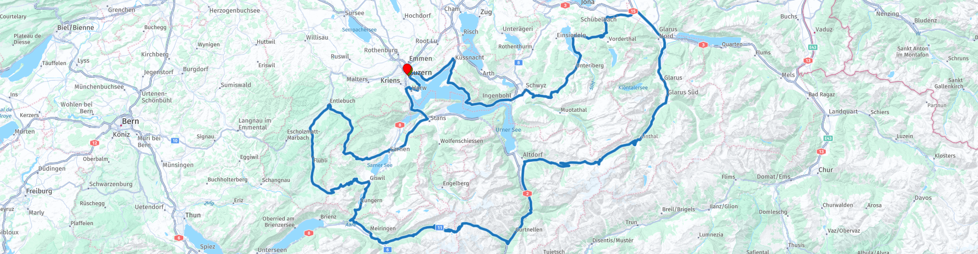
Centraal Zwitserland

This route was brought to you by:
RouteXpert Hans van de Ven (Mr.MRA)
Last edit: 21-08-2023
 Route Summary
 Start: Lucerne
Finish: Lucerne
The route made the same for TomTom, Garmin and MyRoute-app Navigation users.
If you want to ride this TT, keep the info below in mind:
- No mountain experience
- Tour
- Accommodation necessary
- Tol
Source: Promoter 07, September / October 2018.
 Share this route


Animation

Verdict


Duration
8h 2m

Mode of travel
Car or motorcycle

Distance
384.64 km

Countries

 RouteXpert Review
 Passes and mountain roads: Pragel Pass (1550 m), Sattelegg (1190 m), Klausen Pass (1948 m), Susten Pass (2224 m), Engstenalp (1840 m), Brünig Pass (1008 m), Glaubenbüelen Pass (1611 m), Glaubenberg Pass (1540) .
Route details:
- Winter closure: outside the Glaubenberg Pass (November to April) there are no official winter closures. Keep an eye on the weather.
- Toll: the road to the Engstlenalp.
- Alternative routes: toll road to the Engstlenalp and the road from Schwyz to Glarus over the Sattelegg (not always handy for motorcyclists because the Pragel pass is closed for motor vehicles at the weekend)
- Ideal months: Beginning of May until late in the fall.
- Engine: No restrictions
- Roads: Parts of the Glaubenberg Pass are not paved, but doable.
- Driving pleasure: Sattelegg, Pragelpas, Sustenpas, Klausenpas.
- Landscape: Vierwaldstättersee, Lammschlucht (Emme-Durchbruch) north of Flühli.
This 5-star route is one of the 24 most beautiful Alpine routes in recent years!
Colored route points:
rp 1 - Starting point in Lucerne at Hotel Rothaus
rp 12 - Glaubenberg Pass
rp 13 - Stopover: Gfellen, turn right
rp 17 - Glaubenbielen
rp 20 - Lungern viewpoint
rp 21 - Brünigpass
rp 24 - Stopover: Alpin Center Sustenpass
rp 25 - Viewpoint Gadmen
rp 26 - Sustenpass
rp 27 - (Possible) Stopover: Sustenbrüggli
rp 28 - Tank stop: Avia-Tankstelle
rp 31 - Possibility to spend the night at Hotel Stern and Post
rp 35 - Stopover: Klausenpasshöhe on the Klausenpass
rp 36 - Viewpoint Spiringen
rp 41 - Stopover: Bergrestaurant Sattelegg
rp 44 - Ibergeregg
rp 49 - Tank stop: BP
rp 50 - End point in Lucerne at Hotel Rothaus


 Links
Links  Usage
Usage Want to download this route?
You can download the route for free without MyRoute-app account. To do so, open the route and click 'save as'. Want to edit this route?
No problem, start by opening the route. Follow the tutorial and create your personal MyRoute-app account. After registration, your trial starts automatically.  Disclaimer
Use of this GPS route is at your own expense and risk. The route has been carefully composed and checked by a MyRoute-app accredited RouteXpert for use on TomTom, Garmin and MyRoute-app Navigation.
Changes may nevertheless have occurred due to changed circumstances, road diversions or seasonal closures. We therefore recommend checking each route before use.
Preferably use the route track in your navigation system. More information about the use of MyRoute-app can be found on the website under 'Community' or 'Academy'.

Nidwalden
About this region
Nidwalden, also Nidwald (German: (Kanton) Nidwalden, [ˈnidˌvaldən] (listen)) is one of the 26 cantons forming the Swiss Confederation. It is composed of eleven municipalities and the seat of the government and parliament is in Stans. It is traditionally considered a "half-canton", the other half being Obwalden.
Nidwalden lies in Central Switzerland. It borders the canton of Obwalden to the west, the cantons of Lucerne and Schwyz to the north, the canton of Uri to the east and the canton of Bern to the south. The canton is essentially in the Alps, south of Lake Lucerne.
It is one of the smallest cantons, the population is 40,287 (in 2007). The largest town is Stans, followed by Hergiswil and Buochs.
Together with Obwalden, Nidwalden was part of the forest canton of Unterwalden, one of the three participants in the foundation of the Old Swiss Confederacy, named in the Pact of Brunnen of 1315 with Uri and Schwyz. The division of Unterwalden into two separate territories, Obwalden and Nidwalden, appears to develop over the course of the 14th and 15th centuries.
Read more on Wikipedia
Nidwalden lies in Central Switzerland. It borders the canton of Obwalden to the west, the cantons of Lucerne and Schwyz to the north, the canton of Uri to the east and the canton of Bern to the south. The canton is essentially in the Alps, south of Lake Lucerne.
It is one of the smallest cantons, the population is 40,287 (in 2007). The largest town is Stans, followed by Hergiswil and Buochs.
Together with Obwalden, Nidwalden was part of the forest canton of Unterwalden, one of the three participants in the foundation of the Old Swiss Confederacy, named in the Pact of Brunnen of 1315 with Uri and Schwyz. The division of Unterwalden into two separate territories, Obwalden and Nidwalden, appears to develop over the course of the 14th and 15th centuries.
View region
 Statistics
  5
5Amount of RX reviews (Nidwalden)
 12361
12361Amount of visitors (Nidwalden)
 558
558Amount of downloads (Nidwalden)
 Route Collections in this region
 The 24 Most Beautiful Alpine Routes
The Alps, The Alps are a mountain range in Europe, stretching from the French Mediterranean coast in the southwest to the Pannonian Plain in the east. The area of the mountain range is more than 200,000 km².
In other words Passes and Mountain Roads!
Driving through the mountains is great! Especially over the mountain passes with hairpin bends and narrow winding roads. Every bend a different view where you can enjoy. There are many beautiful mountain passes in the Alps.
A selection that has also been incorporated into these routes:
The Stlevio Pass:
The Stelvio Pass, also known as Passo dello Stelvio, is mainly known for the stage in the Giro d'Italia. Due to the length and the difference in height, this pass is seen as one of the toughest tests in cycling. The Stelvio Pass reaches a maximum height of 2758 meters and is therefore one of the highest in the Alps. The pass connects the towns of Bormio and Prato Allo Stelvio. In winter the pass is closed due to heavy snowfall.
The Reschenpass:
The Reschenpass, also known as Passo di Resia, connects the Austrian state of Tyrol with the Italian province of South Tyrol. The pass reaches a maximum height of 1,504 meters and has been one of the most important north-south connections in the Alps in recent centuries. The pass was used long before Roman times. Along the way you will pass several highlights and historical relics. One of the highlights is the Reschensee. This lake was created after the construction of the dam and has completely submerged the village of Graun. The only thing that reminds of that is the clock tower in the middle of the lake.
Col du Galibier:
The French mountain pass Col du Galibier connects the towns of Saint-Michel-de-Maurienne and Briançon via the Col du Lautaret in the south and the Col du Télégraphe in the north. The mountain pass is part of the Tour de France and very much feared, due to the fact that it can only be reached via the other two mountain passes. The pass reaches a maximum height of 2646 meters. From there you can take a walk to the viewpoint at 2704 meters. You can admire the peaks of the Grand Galibier, Mont Blanc and La Meije here.
The Grossglockner High Alpine Road:
With a height of 3798 meters the Grossglockner is the highest mountain in Austria. To fully enjoy this impressive mountain, you can drive over the Grossglockner High Alpine Road and the accompanying pass. The route starts from Bruck am Grossglockner and ends in Heiligenblut. Of course you can drive in two directions. The pass reaches a maximum height of 2504 meters and is closed in winter due to heavy snowfall. Along the way you pass several stops with fun activities, information points, mountain huts and viewpoints. A visit to the Kaiser-Franz-Josefs-Höhe and Pasterzen Glacier is highly recommended.
The Col d'Izoard:
Just like the Col du Galibier, the Col d'Izoard is also part of a stage of the Tour de France. The mountain pass connects Briançon with the valley of the river Guil. The pass is partly located in the Regional Natural Park du Queyras and reaches a maximum height of 2360 meters. What is special about the Col d'Izoard is the barren and rocky landscape. Sometimes it feels like driving a car over the moon! Along the way you can stop at several points to enjoy the beautiful view.
The Bernina Pass:
The Bernina Express is one of the most famous rail trains in Switzerland and the Alps. The route is beautiful and partly included on the UNESCO World Heritage List. Parallel to the railway lies the Bernina pass, which connects the Veltlin valley with the Egandin valley. This beautiful Alpine road has a total length of 56 kilometers and reaches a maximum height of 2328 meters. Along the way you can enjoy views of the Morteratsch Glacier.
The Sella Pass:
The Sella Pass, also known as Passo di Sella, takes you over one of the most impressive mountain ranges in the Dolomites: the Sella massif. The pass connects Valle di Fassa with Val Gardena and reaches a maximum height of 2236 meters. At this height is also the border of the Italian provinces of Trentino and Bolzano. Along the way you can enjoy the view of this spectacular mountain world. Admire, for example, the three peaks of the Sasso Lungo massif, the Sella massif or the peaks of the Marmolada. You can also drive the Sella pass in combination with the Gardena pass, Pordoi pass and Campolongo pass.
The Grimsel Pass:
The Grimsel Pass connects Goms in Wallis with the Halis Valley in the Bernese Oberland. The pass reaches a maximum elevation of 2165 meters and is closed in winter due to snowfall. Over the centuries, the mountain pass has played an important role in trade between Switzerland and Italy. Now it is mainly the reservoirs that have an important function. These are used to generate electricity. The landscape you drive through is rugged, rocky and impressive. On top of the pass is a hotel and a restaurant with a special marmot park. The Dodensee (Totensee) is also located here. This lake owes its name to the many soldiers who died in the time of Napoleon.
The Gotthard Pass:
The Gotthard Pass, also known as Passo del San Gottardo and Saint Gotthard, connects the Swiss towns of Airolo and Andermatt. The mountain pass and associated tunnel are especially known among holidaymakers driving from Switzerland to Italy. But where the majority opt for the tunnel, it is precisely the pass that really completes the holiday. The Gotthard Pass has a length of about 26 kilometers and reaches a maximum height of 2106 meters. The route is beautiful and takes you along old villages and beautiful views.
The Silvretta High Alpine Road and Silvretta Pass:
The Paznaun Valley in Tyrol and the Montafon in Vorarlberg are connected by the Silvretta High Alpine Road. The route has a length of 22.3 kilometers and leads from Galtür to Partenen in 34 hairpin bends, via the 2032 meter high Bielerhöhe. The Silvrettasee is also located at this point, where you can enjoy a lovely walk. The pass is closed in winter due to snowfall.
The Simplon Pass:
Just like the Gotthard Pass, many holidaymakers also travel over the Simplon Pass every year. This mountain pass connects the Rhone Valley in the canton of Valais with the Valle d'Ossola in Piemonte. The pass is open all year round and reaches a maximum height of 2005 meters. Along the way you pass a number of buildings, including the well-known Simplon Hospiz from 1825. The hospiz is managed by the monks of St. Bernard. From the highest point on the pass, all kinds of hiking routes are possible and you will also come across a hotel where you can spend the night.
The Gerlos Pass:
The Gerlos Pass connects the Salzach Valley in the Salzburgerland with the Zillertal Valley in Tyrol. The pass is part of the Gerlos Alpenstraße and runs right through the Hohe Tauern National Park. Along the way you can enjoy beautiful views of the surroundings. The pass has a length of 12 kilometers and reaches a maximum height of 1531 meters. A ride over the Gerlos Pass can be ideally combined with a visit to the Krimmler Wasserfälle.
The Great St. Bernard Pass:
The Great St. Bernard Pass, better known as Col du Grand Saint Bernard, connects the Italian province of Valle d'Aosta with the Swiss canton of Valais. The pass is one of the highest in Switzerland and reaches a maximum height of 2469 meters. Like a number of other mountain passes in this list, the Great St. Bernard Pass has also been used as a connecting road for centuries. The pass is named after the St. Bernard dogs that used to help stranded travelers along with the monks. The pass is closed in winter.
The Timmelsjoch High Alpine Road:
The Timmelsjoch High Alpine Road connects the towns of Sölden in the Ötztal and Meran in South Tyrol. Tolls must be paid on the Hochgurgl - Moos route. Via a mountain road with about 60 hairpin bends you drive through a beautiful mountain world. With the Timmelsjoch Experience you can learn more about the history, the road and the environment via various stations. You can also visit the Top Mountain Crosspoint museum.
Col de l'Iseran:
With a maximum pass height of 2770 meters, the Col l'Iséran is one of the highest mountain passes in the Alps. The pass connects Bourg-Saint-Maurice with Bonneval-sur-Arc. Via a road full of hairpin bends you pass, among other things, Val-d'Isère and a side valley of the Maurienne that lies entirely in the National Park de la Vanoise. You can spot animals such as marmots and chamois and there is also a restaurant with a chapel on top of the pass.
The Gavia Pass:
The Gavia Pass (Italian Passo di Gavia) is a mountain pass in the Italian Alps, in the Lombardy region.
It is one of the highest pass roads in Europe. The road leads through the unspoilt Stelvio National Park. The road was built in the First World War to supply Italian soldiers who fought in the Italian-Austrian border area. The pass height is one of the most beautiful in the Alps. Here is the large Lago Bianco with, to the north, the mountain San Matteo (3684 meters). Lago Nero is slightly lower on the south side of the pass. Here the mountain group of the Adamello determines the view. There are many well-marked walks in the area. During the winter the pass is closed due to the heavy snowfall. The pass is often closed until May and June due to the large amount of snow.
Promoter has made a selection of the 24 Most Beautiful Alpine routes that they have set out in recent years.
The routes go through:
France
Austria
Switzerland
Italy
The most beautiful roads, the most beautiful views, the most beautiful viewpoints. The highest mountains, the fastest descents, hairpin bend after hairpin bend, you name it you can't get enough of it.
If you go on holiday in this region, take advantage of it, ALL routes in this collection have been checked and made equal for TomTom, Garmin and MyRoute-app Navigation by a MyRoute-app RouteXpert.
Have fun with this collection and while driving one of these routes. Enjoy all the beauty that the Alps and the Dolomites have to offer. Click on “View route” to read the review of the chosen route.
I would like to hear your findings about the route(s).
View Route Collection
6 day tour CH IT AT DE over the most famous and also dreamy small passes and elevated roads
The six-day route leads over many of the most beautiful alpine crossings in Switzerland, Austria, Italy and Germany.
The path leads over well-known passes such as the Susten, Albula, Timmelsjoch, the Sellaronda, Drei Zinnen and the Ploecken as well as over the high roads of the Grossglockner and the Zillertal Panorama Road and much more. Highlights are also the countless unknown, dreamy alpine crossings away from the big traffic.
Most Alpine passes are only passable in summer, so be sure to check before you set off whether the passes are open.
The long daily routes as well as several road sections demand a lot and are only suitable for experienced drivers.
View Route Collection