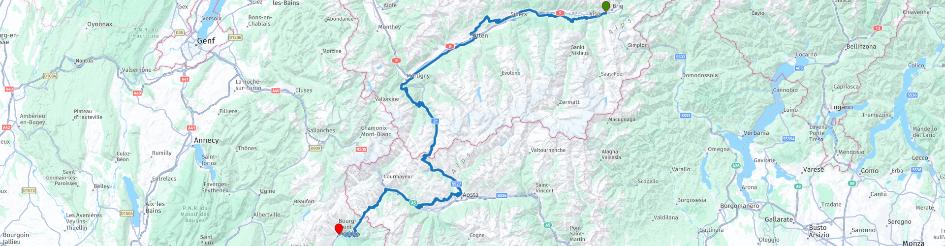
R03 - Brig to Bourg Saint Maurice

This route was brought to you by:
RouteXpert Arno van Lochem - Senior RX
Last edit: 25-08-2021
 Route Summary
 The route starts in Brig at Hotel Olympia. First of all, the Rhône valley has to be 'conquered', but once that has happened you will encounter a number of mountain passes: Hairpin bends and views galore! You will come across the Grand and the Petit Saint Bernard. On top of this latter pass you cross the border with France.
The route ends in Bourg-Saint-Maurice at Hotel Relais de la Venoise.
The route is for the more advanced motorcyclist given the occasional tight hairpin bends in the Alps. Good engine management is desired!
 Share this route


Animation

Verdict


Duration
6h 28m

Mode of travel
Car or motorcycle

Distance
287.64 km

Countries


 RouteXpert Review
 The Rhône is a river that originates in the Rhône glacier near the Furka pass, a pass in the northeast of the canton of Valais and flows from there in a south-westerly direction. The boundaries of the canton correspond to those of the river basin. Until Brig the high mountain valley is called Goms and the river itself is called Rotten. The valley widens sharply at Brig. The river now flows west. Larger places here are Brig, Sion and Martigny, where the river makes a sharp bend to the northwest. 40 km further, the Rhône flows into Lake Geneva.
During the first 100km, the Rhône forms the backdrop for this route. Every now and then there is a little deviation from driving on a nice mountain road, but the river keeps popping up. And yet the river is only crossed twice, most of the first 100km is south of the water.
Just before you cross the Rhône for the first time, you can see a large number of satellite dishes on the mountains you are facing. These are located in the place Leuk and belong to the 'Satelliten Bodenstation Brentjong'.
Brentjong's honeycomb-shaped one-storey station building with its pillar-free interior and enormous circular parabolic antennas at Leuk has long been considered an architectural gem. The architects Heidi and Peter Wenger had built a complex on the gently sloping terrace on the right flank of the Rhône valley between 1972 and 1973, commissioned by PTT, which, despite its imposing dimensions, blended surprisingly well into the environment and at the same time looked futuristic and elegant.
In March 2000, the operator Swisscom withdrew from the satellite communications business. In the future, the company relied on transmission media such as high-quality submarine cables or on purchasing satellite services from other foreign providers. The ground station went to the American company Verestar. As a result, it was repeatedly said that a subsidiary of the buyer had close links with the US Secret Service. Verestar would have ended up in the right company in Leuk: the Onyx reconnaissance and eavesdropping system of the Swiss intelligence service operates its eavesdropping antennas in the same ground station.
In the municipality of Leuk and in the places in the region, there are no concerns about intelligence activities in the satellite earth station. Even at the height of the various wiretapping scandals, there was no criticism. The subject is not very explosive. It is apparently clear to everyone that every country is engaged in espionage, so don't worry about that ...
Unfortunately the station was closed to the public after the death of the founders.
After you have crossed the Rhône you climb higher and higher until you reach the town of Lens. A remarkable museum has been built in that town: The Fondation Pierre Arnoud.
The facade of this museum alone is remarkable: 84 glass solar panels cover this building by architect Jean-Pierre Emery. This reflects the environment of Lac de Louché and the mountain peaks of Wallis. Inside there is approximately 1000 square meters of exhibition space that is arranged with unusual changing exhibitions, amazing. Click on the link below for more information about the exhibition. Not interesting for you? Then it is nice to look at the building from the outside and take a picture, because the location by the lake is beautiful.
The route continues on the right flank of the Rhone Valley until you cross the river again at Sion. You pass this fairly large town on the south side, then you drive a long way along the Rhône. The last 15km through the Rhône valley, the river has been replaced by a railway line. There are no bends in these 15 kilometers, only straight ahead. But do not worry, there will be plenty of curves soon, after Martigny, there will be plenty!
After Martiny has passed the route starts to climb. That does not take too long, because at the first hairpin bend you encounter there is the possibility to stop for a coffee break. This coffee break is planned at restaurant Gorges du Durnand. The restaurant is in a beautiful location, surrounded by greenery at the tip of a hairpin bend. Order a cup of coffee, sit on the terrace and be amazed at what goes up and down the pass. Great to see!
The gorge of the same name, which has the entrance at the restaurant, was built in 1877 and completely renovated in 1987. The gorge offers a breathtaking spectacle, which makes it one of the ten most beautiful in Europe.
Located in the town of Bovernier, the visible part of the Gorges du Durnand extends for about 1 kilometer. It is accessed by a small rural path, lined by blueberries and wild strawberries, that suddenly turns into a series of hanging wooden walkways and stairs (330 steps in total) that provide visitors with amazing views. Be well informed by the information boards or the staff in the restaurant before entering the gorge. It's a tough walk!
After coffee you continue the route up the mountain, the Col de Champex, a pass that has its highest point at 1498m. On top of the pass you will pass through Champex-Lac, a picturesque mountain village. On the edge is a beautiful lake, which should definitely be taken a picture.
Just after the lake you will find the 'Fort d'artillerie de Champex-Lac' on the left. That's a fortress hidden under the Alps. Built in 1940-1943 it is a relic of the 2nd World War, although it was used by the Swiss army until 1998 after modernization for a possible nuclear conflict. More than 600 meters of corridor have been dug into the mountain. Completely invisible from the outside, with space for 300 people. For information about opening hours and admission prices, see the link below.
After Champex-Lac you descend to Orsières, where you will get a fantastic piece of asphalt under wheels that will take you towards the border with Italy. In fact, the climb of the Col du Grand Saint-Bernard starts here with a pass height of 2469m. Slowly but surely, the number of vertical meters is increasing. Just before the road you are driving on disappears into the tunnel, turn off and drive up the old pass. Not very good asphalt on the Swiss side. After a few kilometers there is a concrete construction along the road, Aeration du tunnel. That is the aeration of the tunnel, in this place it runs right under you.
The route continues to climb until you are on top. A lake forms the last part of Switzerland, at the end of this lake you enter Italy. And then ... the descent. Truly a great stretch of asphalt, beautiful views, beautiful curves and tunnels, all great. This descent is in my top three! 15 kilometers Enjoy with a big G!
Unfortunately, this beauty will come to an end far too soon, but there will soon be even more to enjoy.
You follow the route further towards Aosta. Just above this place you turn to the east, but you do not follow the big busy road, but the smaller mountain roads. That means steering, steering and steering again!
Arriving at Pré-Saint-Didier, the route turns southwest. Here you start the ascent of today's last col, the Col du Grand Saint-Bernard. On top of this col you will pass the French border. But before that happens you first have to process 8 tight hairpin bends on asphalt of great quality. Slowly but surely you climb higher and higher, trees become a rarity at this height and have made way for grass and bare rocks.
Although Aosta has been behind you for some time, you still drive through the Aosta valley. Just before the border, at Lago di Verney, there is an opportunity to take a last photo of the Aosta valley before you leave Italy for France.
Once you have passed the border, you immediately notice something. Asphalt is less, not really bad, but bumpy, not as tight as in Italy. And a guardrail? More than that, and often a wall of 40cm high. Not a good idea to come into contact with that during the 25 kilometer descent that you now have in front of the wheels.
Once you have reached the bottom, you enter the town of Bourg-Saint-Maurice, where today's final destination can be found, hotel Relais de la Renoise.
Have fun driving this route!


 Links
Links  Usage
Usage Want to download this route?
You can download the route for free without MyRoute-app account. To do so, open the route and click 'save as'. Want to edit this route?
No problem, start by opening the route. Follow the tutorial and create your personal MyRoute-app account. After registration, your trial starts automatically.  Disclaimer
Use of this GPS route is at your own expense and risk. The route has been carefully composed and checked by a MyRoute-app accredited RouteXpert for use on TomTom, Garmin and MyRoute-app Navigation.
Changes may nevertheless have occurred due to changed circumstances, road diversions or seasonal closures. We therefore recommend checking each route before use.
Preferably use the route track in your navigation system. More information about the use of MyRoute-app can be found on the website under 'Community' or 'Academy'.

Valais
About this region
Valais (in French) (UK: VAL-ay, US: val-AY, French: [valɛ] (listen); Arpitan: Valês), or Wallis (in German) (German: Wallis [ˈvalɪs] (listen)), more formally the Canton of Valais, is one of the 26 cantons forming the Swiss Confederation. It is composed of thirteen districts and its capital and largest city is Sion. The flag of the canton is made of thirteen stars representing the districts, on a white-red background.
Valais is situated in the southwestern part of the country. It borders the cantons of Vaud and Bern to the north, the cantons of Uri and Ticino to the east, as well as Italy to the south and France to the west. It is one of the three large southern Alpine cantons, along with Ticino and the Grisons. It is a bilingual canton, French and German being its two official languages. Traditionally, the canton is divided into Lower, Central and Upper Valais, the latter region constituting the German-speaking minority.
Valais essentially coincides with the valley of the Rhône from its headwaters to Lake Geneva, separating the Pennine Alps from the Bernese Alps. A major wine region, the canton is simultaneously one of the driest regions of Switzerland in its central Rhône valley and among the wettest, having large amounts of snow and rain up on the highest peaks found in Switzerland, such as Monte Rosa and the Finsteraarhorn. Although a major hydroelectricity producer, Valais is essentially renowned for its tourism industry and for its numerous Alpine resort towns, notably Crans-Montana, Saas Fee, Verbier and Zermatt. Overlooking the latter town, the Matterhorn has become an iconic landmark of the canton.
In 1529, Valais became an associate member of the Swiss Confederation. After having resisted the Protestant Reformation and remained faithful to the Roman Catholic Church, it became a republic under the guidance of the prince-bishop of Sion in 1628. In 1815, Valais finally entered the Swiss Confederation as a canton.
Read more on Wikipedia
Valais is situated in the southwestern part of the country. It borders the cantons of Vaud and Bern to the north, the cantons of Uri and Ticino to the east, as well as Italy to the south and France to the west. It is one of the three large southern Alpine cantons, along with Ticino and the Grisons. It is a bilingual canton, French and German being its two official languages. Traditionally, the canton is divided into Lower, Central and Upper Valais, the latter region constituting the German-speaking minority.
Valais essentially coincides with the valley of the Rhône from its headwaters to Lake Geneva, separating the Pennine Alps from the Bernese Alps. A major wine region, the canton is simultaneously one of the driest regions of Switzerland in its central Rhône valley and among the wettest, having large amounts of snow and rain up on the highest peaks found in Switzerland, such as Monte Rosa and the Finsteraarhorn. Although a major hydroelectricity producer, Valais is essentially renowned for its tourism industry and for its numerous Alpine resort towns, notably Crans-Montana, Saas Fee, Verbier and Zermatt. Overlooking the latter town, the Matterhorn has become an iconic landmark of the canton.
In 1529, Valais became an associate member of the Swiss Confederation. After having resisted the Protestant Reformation and remained faithful to the Roman Catholic Church, it became a republic under the guidance of the prince-bishop of Sion in 1628. In 1815, Valais finally entered the Swiss Confederation as a canton.
View region
 Statistics
  19
19Amount of RX reviews (Valais)
 12777
12777Amount of visitors (Valais)
 1209
1209Amount of downloads (Valais)
 Route Collections in this region
 The 24 Most Beautiful Alpine Routes
The Alps, The Alps are a mountain range in Europe, stretching from the French Mediterranean coast in the southwest to the Pannonian Plain in the east. The area of the mountain range is more than 200,000 km².
In other words Passes and Mountain Roads!
Driving through the mountains is great! Especially over the mountain passes with hairpin bends and narrow winding roads. Every bend a different view where you can enjoy. There are many beautiful mountain passes in the Alps.
A selection that has also been incorporated into these routes:
The Stlevio Pass:
The Stelvio Pass, also known as Passo dello Stelvio, is mainly known for the stage in the Giro d'Italia. Due to the length and the difference in height, this pass is seen as one of the toughest tests in cycling. The Stelvio Pass reaches a maximum height of 2758 meters and is therefore one of the highest in the Alps. The pass connects the towns of Bormio and Prato Allo Stelvio. In winter the pass is closed due to heavy snowfall.
The Reschenpass:
The Reschenpass, also known as Passo di Resia, connects the Austrian state of Tyrol with the Italian province of South Tyrol. The pass reaches a maximum height of 1,504 meters and has been one of the most important north-south connections in the Alps in recent centuries. The pass was used long before Roman times. Along the way you will pass several highlights and historical relics. One of the highlights is the Reschensee. This lake was created after the construction of the dam and has completely submerged the village of Graun. The only thing that reminds of that is the clock tower in the middle of the lake.
Col du Galibier:
The French mountain pass Col du Galibier connects the towns of Saint-Michel-de-Maurienne and Briançon via the Col du Lautaret in the south and the Col du Télégraphe in the north. The mountain pass is part of the Tour de France and very much feared, due to the fact that it can only be reached via the other two mountain passes. The pass reaches a maximum height of 2646 meters. From there you can take a walk to the viewpoint at 2704 meters. You can admire the peaks of the Grand Galibier, Mont Blanc and La Meije here.
The Grossglockner High Alpine Road:
With a height of 3798 meters the Grossglockner is the highest mountain in Austria. To fully enjoy this impressive mountain, you can drive over the Grossglockner High Alpine Road and the accompanying pass. The route starts from Bruck am Grossglockner and ends in Heiligenblut. Of course you can drive in two directions. The pass reaches a maximum height of 2504 meters and is closed in winter due to heavy snowfall. Along the way you pass several stops with fun activities, information points, mountain huts and viewpoints. A visit to the Kaiser-Franz-Josefs-Höhe and Pasterzen Glacier is highly recommended.
The Col d'Izoard:
Just like the Col du Galibier, the Col d'Izoard is also part of a stage of the Tour de France. The mountain pass connects Briançon with the valley of the river Guil. The pass is partly located in the Regional Natural Park du Queyras and reaches a maximum height of 2360 meters. What is special about the Col d'Izoard is the barren and rocky landscape. Sometimes it feels like driving a car over the moon! Along the way you can stop at several points to enjoy the beautiful view.
The Bernina Pass:
The Bernina Express is one of the most famous rail trains in Switzerland and the Alps. The route is beautiful and partly included on the UNESCO World Heritage List. Parallel to the railway lies the Bernina pass, which connects the Veltlin valley with the Egandin valley. This beautiful Alpine road has a total length of 56 kilometers and reaches a maximum height of 2328 meters. Along the way you can enjoy views of the Morteratsch Glacier.
The Sella Pass:
The Sella Pass, also known as Passo di Sella, takes you over one of the most impressive mountain ranges in the Dolomites: the Sella massif. The pass connects Valle di Fassa with Val Gardena and reaches a maximum height of 2236 meters. At this height is also the border of the Italian provinces of Trentino and Bolzano. Along the way you can enjoy the view of this spectacular mountain world. Admire, for example, the three peaks of the Sasso Lungo massif, the Sella massif or the peaks of the Marmolada. You can also drive the Sella pass in combination with the Gardena pass, Pordoi pass and Campolongo pass.
The Grimsel Pass:
The Grimsel Pass connects Goms in Wallis with the Halis Valley in the Bernese Oberland. The pass reaches a maximum elevation of 2165 meters and is closed in winter due to snowfall. Over the centuries, the mountain pass has played an important role in trade between Switzerland and Italy. Now it is mainly the reservoirs that have an important function. These are used to generate electricity. The landscape you drive through is rugged, rocky and impressive. On top of the pass is a hotel and a restaurant with a special marmot park. The Dodensee (Totensee) is also located here. This lake owes its name to the many soldiers who died in the time of Napoleon.
The Gotthard Pass:
The Gotthard Pass, also known as Passo del San Gottardo and Saint Gotthard, connects the Swiss towns of Airolo and Andermatt. The mountain pass and associated tunnel are especially known among holidaymakers driving from Switzerland to Italy. But where the majority opt for the tunnel, it is precisely the pass that really completes the holiday. The Gotthard Pass has a length of about 26 kilometers and reaches a maximum height of 2106 meters. The route is beautiful and takes you along old villages and beautiful views.
The Silvretta High Alpine Road and Silvretta Pass:
The Paznaun Valley in Tyrol and the Montafon in Vorarlberg are connected by the Silvretta High Alpine Road. The route has a length of 22.3 kilometers and leads from Galtür to Partenen in 34 hairpin bends, via the 2032 meter high Bielerhöhe. The Silvrettasee is also located at this point, where you can enjoy a lovely walk. The pass is closed in winter due to snowfall.
The Simplon Pass:
Just like the Gotthard Pass, many holidaymakers also travel over the Simplon Pass every year. This mountain pass connects the Rhone Valley in the canton of Valais with the Valle d'Ossola in Piemonte. The pass is open all year round and reaches a maximum height of 2005 meters. Along the way you pass a number of buildings, including the well-known Simplon Hospiz from 1825. The hospiz is managed by the monks of St. Bernard. From the highest point on the pass, all kinds of hiking routes are possible and you will also come across a hotel where you can spend the night.
The Gerlos Pass:
The Gerlos Pass connects the Salzach Valley in the Salzburgerland with the Zillertal Valley in Tyrol. The pass is part of the Gerlos Alpenstraße and runs right through the Hohe Tauern National Park. Along the way you can enjoy beautiful views of the surroundings. The pass has a length of 12 kilometers and reaches a maximum height of 1531 meters. A ride over the Gerlos Pass can be ideally combined with a visit to the Krimmler Wasserfälle.
The Great St. Bernard Pass:
The Great St. Bernard Pass, better known as Col du Grand Saint Bernard, connects the Italian province of Valle d'Aosta with the Swiss canton of Valais. The pass is one of the highest in Switzerland and reaches a maximum height of 2469 meters. Like a number of other mountain passes in this list, the Great St. Bernard Pass has also been used as a connecting road for centuries. The pass is named after the St. Bernard dogs that used to help stranded travelers along with the monks. The pass is closed in winter.
The Timmelsjoch High Alpine Road:
The Timmelsjoch High Alpine Road connects the towns of Sölden in the Ötztal and Meran in South Tyrol. Tolls must be paid on the Hochgurgl - Moos route. Via a mountain road with about 60 hairpin bends you drive through a beautiful mountain world. With the Timmelsjoch Experience you can learn more about the history, the road and the environment via various stations. You can also visit the Top Mountain Crosspoint museum.
Col de l'Iseran:
With a maximum pass height of 2770 meters, the Col l'Iséran is one of the highest mountain passes in the Alps. The pass connects Bourg-Saint-Maurice with Bonneval-sur-Arc. Via a road full of hairpin bends you pass, among other things, Val-d'Isère and a side valley of the Maurienne that lies entirely in the National Park de la Vanoise. You can spot animals such as marmots and chamois and there is also a restaurant with a chapel on top of the pass.
The Gavia Pass:
The Gavia Pass (Italian Passo di Gavia) is a mountain pass in the Italian Alps, in the Lombardy region.
It is one of the highest pass roads in Europe. The road leads through the unspoilt Stelvio National Park. The road was built in the First World War to supply Italian soldiers who fought in the Italian-Austrian border area. The pass height is one of the most beautiful in the Alps. Here is the large Lago Bianco with, to the north, the mountain San Matteo (3684 meters). Lago Nero is slightly lower on the south side of the pass. Here the mountain group of the Adamello determines the view. There are many well-marked walks in the area. During the winter the pass is closed due to the heavy snowfall. The pass is often closed until May and June due to the large amount of snow.
Promoter has made a selection of the 24 Most Beautiful Alpine routes that they have set out in recent years.
The routes go through:
France
Austria
Switzerland
Italy
The most beautiful roads, the most beautiful views, the most beautiful viewpoints. The highest mountains, the fastest descents, hairpin bend after hairpin bend, you name it you can't get enough of it.
If you go on holiday in this region, take advantage of it, ALL routes in this collection have been checked and made equal for TomTom, Garmin and MyRoute-app Navigation by a MyRoute-app RouteXpert.
Have fun with this collection and while driving one of these routes. Enjoy all the beauty that the Alps and the Dolomites have to offer. Click on “View route” to read the review of the chosen route.
I would like to hear your findings about the route(s).
View Route Collection
Pass Parade Alps and Dolomites
The Alps, a mountain range in Europe that stretches from the French Mediterranean coast in the southwest to the Pannonian plain in the east, almost always guarantee beautiful routes. It can hardly be boring there. The many passes, vistas and variations in the landscape make the Alps a true motorcyclist's paradise. Driving around in the Alps is really quite an experience. You haven't gone through one bend yet or the next one is already on its way. Climbing from the valley, see the landscape change from wooded slopes with splashing waterfalls to alpine meadows where no trees can be found and asphalt roads that cut through the eternal snow. Arriving on top of the mountain, enjoy phenomenal views over the surrounding snow-capped peaks, as if you were on the roof of the world.
The Dolomites also form a fantastic mountain world. They are located east of the Eisacktal, through which the “Brenner Autobahn” runs, which only ends at Bolzano. The area is located in the southernmost part of the Alps, but offers a fantastic, often rugged and unreal sight due to the huge rocky peaks. Peaks that rise steeply above the green wooded slopes and Almen. Truly breathtakingly beautiful roads have been built between the peaks.
How nice would it be if these two areas were strung together by a number of routes that take in a selection of the most beautiful passes in both areas? This collection provides you with that. Starting point is the Postillion Hotel in Arnhem, where you can visit both these beautiful areas in 10 days/routes and get 35 great passes under your wheels. The 'big boys' such as the Stelvio, Timmelsjoch, Pordoi and Gardena are on the list, but also the less well-known passes in the south of the Dolomites, such as the Passo Staulanza, the Passo Rolle and the Passo Duran. In the meantime, visiting the highest asphalted point in Austria at 2829 meters is also possible. After more than 3100 kilometers you end up at the Postillion Hotel in Arnhem.
A number of sights are discussed in the review for each route. These often tell you what you see and what to do. Fun facts, quite educational. Often there are also places indicated where you can find some entertainment, for example a suspension bridge at a great height. You are completely free to visit these sights, you can of course also determine your own points of interest.
But the main thing you most likely traveled to these areas for is simply driving. And as mentioned above, you are in a true motorcycle paradise where the steering is fantastic!
Each route ends at a hotel. It is of course not an obligation to use these hotels, you can always find another place to stay in the area, that is entirely up to you. However, my experience is that they are all simple but good hotels for a very reasonable price. They are known at/can be booked via booking.com (subject to change)
The routes of these collections:
R01 Arnhem to Riol, 355km
R02 Riol to Voehrenbach, 311km
R03 Voehrenbach to Innertkirchen, 257km
R04 Innertkirchen to Susch, 303km
R05 Susch to Selva di Val Gardena, 301km
R06 Selva di Val Gardena to Castello Molina di Fiemme, 272km
R07 Castello Molina di Fiemme to Reutte, 289km
R08 Reutte to Voehrenbach, 273km
R09 Voehrenbach to Riol, 367km
R10 Riol to Arnhem, 341km
Have fun driving these routes!
View Route Collection