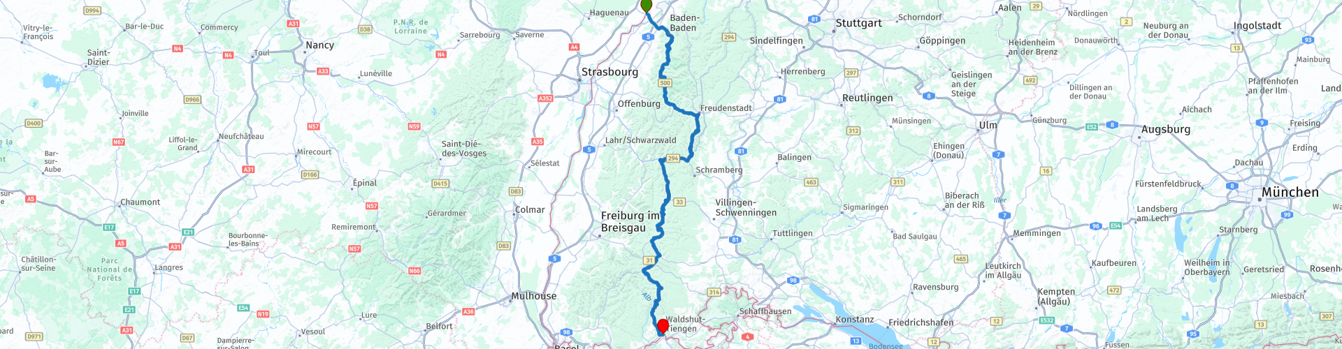
Van Baden Baden naar Waldshut Tiengen Dwars door het zwarte woud via de Schwarzwaldhochstrasse en de B500

This route was brought to you by:
RouteXpert Stijn Claus
Last edit: 23-03-2019
 Route Summary
 This route runs straight through the Black Forest, at an altitude between 800 and 1000 meters.
The road surface is in excellent condition.
 Share this route


Animation

Verdict


Duration
3h 42m

Mode of travel
Car or motorcycle

Distance
220.95 km

Countries

 RouteXpert Review
 First we follow the Northern B500, better known as the Schwarzwaldhochstraße.
The name Schwarzwaldhochstraße was first used in 1930 after the completion of the section of the road between Hundseck and Untersmatt. The road made access to the high Black Forest easier. Under the Third Reich, further construction was done for strategic reasons, including completing the piece between Ruhestein and Alexanderschanze (between 1938 and 1941). The entire route from Baden-Baden to Freudenstadt was completed in 1952.
This road starts in Baden-Baden and rises quickly to the most important ridge of the northern Black Forest and reaches the summit at the Bühlerhöhe. In clear weather there is a wide view over the plain of the Rhine towards the Vosges.
From the Bühlerhöhe, the Hochstraße runs at an altitude between 800 and 1,000 meters above sea level.
At the bottom of the highest mountain in the northern Black Forest, the Hornisgrinde 1,164 meters high, the road reaches the almost circular Mummelsee, a kettle valley from the last ice age
The road then continues over the Schliffkopf and Kniebis, past Zuflucht and the Alexanderschanze to end up in the city of Freudenstadt.
We then follow the B294 and then continue on the B33 to follow the B500 back to Switzerland at Trimberg im Swarzwald. The remaining part of the B500 traverses the southern Black Forest.
We pass on the Titisee and the Schuchsee and the viewpoint Gupfen viewpoint. When the weather is nice you have a wonderful view of the Swiss Alps, the Black Forest, the Hotzenwald and the Rhine plain.
The route ends again on the Rhine, which this time forms the border between Germany and Switzerland.


 Links
Links  Usage
Usage Want to download this route?
You can download the route for free without MyRoute-app account. To do so, open the route and click 'save as'. Want to edit this route?
No problem, start by opening the route. Follow the tutorial and create your personal MyRoute-app account. After registration, your trial starts automatically.  Disclaimer
Use of this GPS route is at your own expense and risk. The route has been carefully composed and checked by a MyRoute-app accredited RouteXpert for use on TomTom, Garmin and MyRoute-app Navigation.
Changes may nevertheless have occurred due to changed circumstances, road diversions or seasonal closures. We therefore recommend checking each route before use.
Preferably use the route track in your navigation system. More information about the use of MyRoute-app can be found on the website under 'Community' or 'Academy'.

Baden-Württemberg
About this region
Baden-Württemberg (; German: [ˌbaːdn̩ ˈvʏʁtəmbɛʁk] (listen)), commonly shortened to BW or BaWü, is a German state (Bundesland) in Southwest Germany, east of the Rhine, which forms the southern part of Germany's western border with France. With more than 11.07 million inhabitants as of 2019 across a total area of nearly 35,752 km2 (13,804 sq mi), it is the third-largest German state by both area (behind Bavaria and Lower Saxony) and population (behind North Rhine-Westphalia and Bavaria). As a federated state, Baden-Württemberg is a partly-sovereign parliamentary republic. The largest city in Baden-Württemberg is the state capital of Stuttgart, followed by Mannheim and Karlsruhe. Other major cities are Freiburg im Breisgau, Heidelberg, Heilbronn, Pforzheim, Reutlingen, Tübingen, and Ulm.
What is now Baden-Württemberg was formerly the historical territories of Baden, Prussian Hohenzollern, and Württemberg. Baden-Württemberg became a state of West Germany in April 1952 by the merger of Württemberg-Baden, South Baden, and Württemberg-Hohenzollern. These states had just been artificially created by the Allies after World War II out of the existing traditional states Baden and Württemberg by their separation over different occupation zones.
Baden-Württemberg is especially known for its strong economy with various industries like car manufacturing, electrical engineering, mechanical engineering, the service sector, and more. It has the third highest gross regional product (GRP) in Germany. Part of the Four Motors for Europe, some of the largest German companies are headquartered in Baden-Württemberg, including Daimler, Porsche, Bosch and SAP.
The sobriquet Ländle (a diminutive of the word "Land" in the local Swabian, Alemannic and Franconian dialects) is sometimes used as a synonym for Baden-Württemberg.
Read more on Wikipedia
What is now Baden-Württemberg was formerly the historical territories of Baden, Prussian Hohenzollern, and Württemberg. Baden-Württemberg became a state of West Germany in April 1952 by the merger of Württemberg-Baden, South Baden, and Württemberg-Hohenzollern. These states had just been artificially created by the Allies after World War II out of the existing traditional states Baden and Württemberg by their separation over different occupation zones.
Baden-Württemberg is especially known for its strong economy with various industries like car manufacturing, electrical engineering, mechanical engineering, the service sector, and more. It has the third highest gross regional product (GRP) in Germany. Part of the Four Motors for Europe, some of the largest German companies are headquartered in Baden-Württemberg, including Daimler, Porsche, Bosch and SAP.
The sobriquet Ländle (a diminutive of the word "Land" in the local Swabian, Alemannic and Franconian dialects) is sometimes used as a synonym for Baden-Württemberg.
View region
 Statistics
  58
58Amount of RX reviews (Baden-Württemberg)
 40793
40793Amount of visitors (Baden-Württemberg)
 9642
9642Amount of downloads (Baden-Württemberg)
 Route Collections in this region
 Top 5 Car and Motorcycle Routes in the Black Forest
The Black Forest, who hasn't heard of it? The Black Forest is a densely forested area and low mountain range in southwestern Germany, located in the state of Baden-Württemberg, on the Rhine and the French border. It is the largest low mountain range in Germany. Geologically, it is related to the Vosges Mountains, which lie on the French side of the Rhine. The highest peak of the Black Forest is the Feldberg with a height of 1493 meters above sea level. The Black Forest is the largest forest area in Germany and consists mainly of pine and spruce trees. The Black Forest is known as one of the most popular tourist destinations in Germany. A small part in the north is protected as the Schwarzwald National Park. The Romans called the densely forested mountain range with its distinctive dark conifers Silva Nigra - "the Black or Dark Forest or impenetrable forest", which to them was ominous and almost impenetrable. The German word Schwarzwald was used for the first time in a document from the Swiss monastery of St. Gallen from the year 868. A well-known car route is the Schwarzwald-Hochstraße, B 500 and the Uhrenstraße. The Black Forest is known worldwide for the fairy tales of the Brothers Grimm.
There are also several lakes in the Black Forest, namely: Titisee, Glaswaldsee, Mummelsee, Kirnbergsee, Feldsee, Schluchsee and the Hotzenwald.
The highest peaks in the Black Forest are: Feldberg (1493 m), Seebuck (1448 m), Herzogenhorn (1415 m), Belchen (1414 m), Schauinsland (1284 m), Kandel (1243 m) and the Hornisgrinde (1164 m ).
Reason enough for the MyRoute app RouteXpert to compile a Top 5 of Car and Motorcycle Routes for you.
All routes in this collection have been checked and made equal for TomTom, Garmin and MyRoute-app Navigation by a MyRoute-app RouteXpert.
If you think, I have a very nice route that should certainly not be missing from this collection, send it to:
email: routeexpert@myrouteapp.com
Subject: New Route for the Top 5 collection Black Forest composed by Hans van de Ven.
The route will then be reviewed and then added to the Top 5. To make the Top 5 also the Top 5, 1 route will have to disappear from the Top 5, you can indicate this when submitting the new route.
Have fun with this collection and while driving one of these routes. Enjoy all the beauty that the Black Forest has to offer. Click on “View route” to read the review of the chosen route.
I would like to hear your findings about the route(s).
View Route Collection
11 day trip from the Netherlands
8 countries in 11 days; The Netherlands, Germany, Austria, Italy, Switzerland, France, Luxembourg and Belgium. This route collections consists of 10 routes that I have driven with friends in the summer of 2019.
The start is in Geldermalsen Netherlands, the first 7 days you drive through the Netherlands, Germany, Austria, Italy, Switzerland, France and a piece of Luxembourg with overnight stays in hotels.
The last three days you stay in Barweiler (D) in the Eifel and you drive two beautiful tours through the Eifel, Luxembourg and parts of the Belgian Ardennes.
There is no highway in the routes, only beautiful provincial and country roads, many beautiful passes with beautiful panoramas.
Be sure to check whether the passes are open before you leave.
These are routes for experienced drivers.
View Route Collection