MTG2 03 Bourgogne Roundtrip southern Morvan

This route was brought to you by:
RouteXpert René Plücken (MRA Master)
Last edit: 12-02-2021
 Route Summary
 climate. It is not for nothing that you see so many motorcyclists there. My previous series of routes in France were based on the route descriptions from the Motortourgids France part 1 made by Bert Loorbach.
This route comes from Motortourgids France part 2 and the original name is "Bougogne; Route description 1: the southern Morvan".
In Motorbike guide France part 2 a difference has been made between approach routes and trips in a certain area. The approach routes can also be used in combination with the routes from Motortourgids France part 1
The routes are sometimes slightly adjusted based on the tips that Bert Loorbach gives in his description, or because of a different place to spend the night, or to achieve the minimum length of 2 hours for the MRA Library. For each route there is a more detailed description in the review, including options to stay overnight or places of interest en route, which are also indicated with a POI and if possible with a short description
The route is made suitable for Garmin, TomTom, Harley-Davidson BoomBox 2019 and Navigation App, can be downloaded for free and without My-Route-app registration. To do this, first click on the 'Use route' button and then on 'Save as'.
 Share this route


Animation

Verdict


Duration
4h 47m

Mode of travel
Car or motorcycle

Distance
259.77 km

Countries

 RouteXpert Review
 Burgundy is roughly in the rectangle Dijon, Auxerre, Nevers and Macon. It is therefore also a nice trip for a long weekend or a mid-week for people who can't get away too long, but want to taste the real French atmosphere. Secondly, nature is very beautiful, three-quarters of the Morvan, the heart of Burgundy, consists of forest and there is water everywhere in the form of streams, rivers, lake and reservoirs. Culturally, Burgundy is rich, there are plenty of Romanesque churches and pretty towns, so plenty of good things to stop along the way for some sightseeing and to take pictures.
You can indulge yourself with a motorbike tour, there are countless small roads that lead you through the forests, along the lakes and the rivers from one charming place to the next. The approach routes to Burgundy are described in routes 1 and 2 from this series. This review describes the first of 2 routes in this beautiful area.
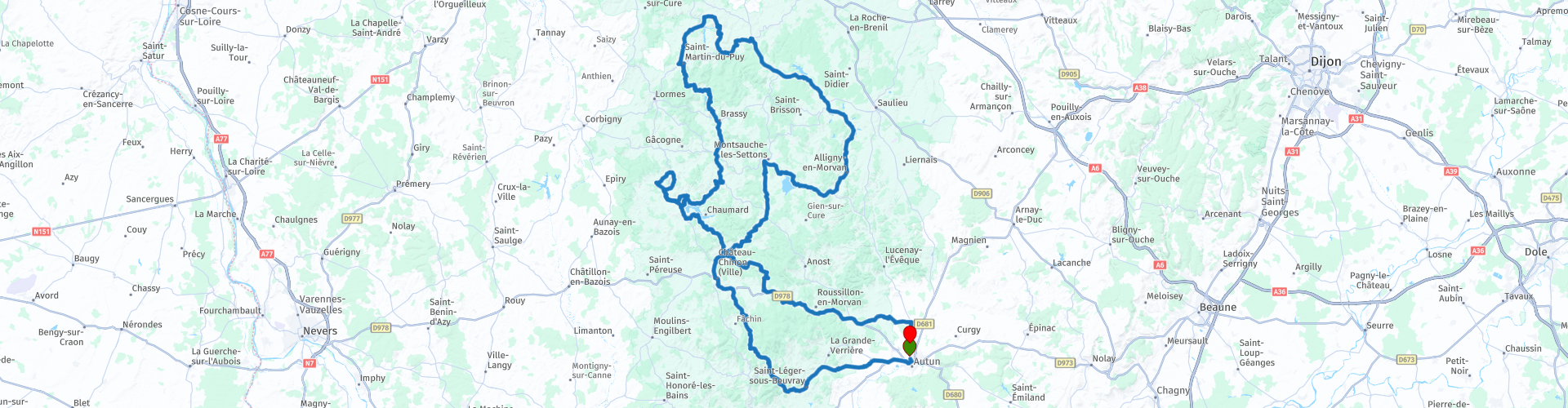
A glance at the map shows a jumble of roads and a landscape that is spotted with many lakes. The aim of this trip is to visit as many lakes as possible. for water lovers it is a party, but also for the knight knights, as well as the lovers of really small country roads and villages. Those interested in water management also get to see enough: the dams in this area control the water supply of the Seine Basin and so is Paris. The original route as described in the Motorbike Guide start is in Château-Chinon (RP4), but I have described the route from the campsite in Autun, the end point of the second approach route to Burgundy.
We drive on the beautiful winding D3 through a beautiful green and wooded area to Bibracte (RP3). This is an open-air museum of the excavations of the Gallic fortified town of Bibracte, identified with the current Mont Beuvray in the French Morvan mountain region. The Bibracte name may mean double reinforced. The city of Bibracte, founded on one of the peaks of the Haut-Morvan, was the capital of the mighty tribe of Haedui.
The route continues to Château-Chinon where we start the original route and after a short stretch on the D944, turn right onto the 340-meter-long dam (RP7) over the 'Lac de pannesière-Chaumard'. At the end we turn right and then immediately sharp left to drive to the aqueduct of Montreuillon. This is 152 meters
long water bridge brings the water from the drainage channel of the Yonne to the other side of the valley of the original course of this river. We drive back via a narrow winding road to the reservoir, at RP14 is a small beach where you can stop for a cooling dip in nice weather.
We continue on a beautiful winding road to the small town of Ouroux-en-Morvan (RP16) with a large church in the middle of the village.
At RP18 we drive over the Hydroelectric Dam “Réservoir du Bois de Chaum” and at RP19 water sports enthusiasts have the option of renting a kayak or rafting on the fast-flowing river.
We continue on wonderfully winding roads such as the D235, D944, D128 and D55 to the small town of Quarré-les-Tombes, where we stop for lunch.
We then drive back via beautiful roads with many curves and beautiful panoramas of the green and hilly French landscape back to the campsite in Autan.
This last part has no special points to stop for a while but I still appreciate this route with 5 ***** stars because of the beautiful roads, the villages, the beautiful lakes and panoramas en route.


 Links
Links  Usage
Usage Want to download this route?
You can download the route for free without MyRoute-app account. To do so, open the route and click 'save as'. Want to edit this route?
No problem, start by opening the route. Follow the tutorial and create your personal MyRoute-app account. After registration, your trial starts automatically.  Disclaimer
Use of this GPS route is at your own expense and risk. The route has been carefully composed and checked by a MyRoute-app accredited RouteXpert for use on TomTom, Garmin and MyRoute-app Navigation.
Changes may nevertheless have occurred due to changed circumstances, road diversions or seasonal closures. We therefore recommend checking each route before use.
Preferably use the route track in your navigation system. More information about the use of MyRoute-app can be found on the website under 'Community' or 'Academy'.