MTG2 06 Autun La Clayette Tarare Bourg Argental

This route was brought to you by:
RouteXpert René Plücken (MRA Master)
Last edit: 12-02-2021
 Route Summary
 climate. It is not for nothing that you see so many motorcyclists there. My previous series of routes in France were based on the route descriptions from the Motortourgids France part 1 made by Bert Loorbach.
This route comes from Motortourgids France part 2 and the original name is "From Burgundy to the Rhone Valley; Route description 2: Over the Col de la République".
In Motorbike guide France part 2 a difference has been made between approach routes and trips in a certain area. The approach routes can also be used in combination with the routes from Motortourgids France part 1
The routes are sometimes slightly adjusted based on the tips that Bert Loorbach gives in his description, or because of a different place to spend the night, or to achieve the minimum length of 2 hours for the MRA Library. For each route there is a more detailed description in the review, including options to stay overnight or places of interest en route, which are also indicated with a POI and if possible with a short description
The route is made suitable for Garmin, TomTom, Harley-Davidson BoomBox 2019 and Navigation App, can be downloaded for free and without My-Route-app registration. To do this, first click on the 'Use route' button and then on 'Save as'.
 Share this route


Animation

Verdict


Duration
4h 46m

Mode of travel
Car or motorcycle

Distance
256.06 km

Countries

 RouteXpert Review
 Three routes are on the west side and one route runs between Clermont-Ferrand and Lyon where you can enjoy the beautiful plateau of the Velay. This is also very suitable if you come from western Burgundy. Then one along St. Étienne and the Col de Ia République, and one that stays reasonably close to Lyon and comes out just below, in Givors. The eastern route is an alternative for those who like to descend on this side as nationally as possible.
This detour route ensures a relaxed drive through forests and over green hills to the south. The only downside is that it is difficult to get a little creative around St. Étienne. A number of kilometers are covered in this urban area. Hence the choice for the fast bypass.
This is compensated by the fantastic end piece with the Col de la République, an 1161 meter high mountain pass in the Pilat massif, on the edge of the Massif Central. The road across the pass, the D1028, connects Saint-Étienne with the Rhone valley. This col is also called the Col du Grand Bois. And this name is right, we drive under the mighty pine trees and there is no shortage of turns.
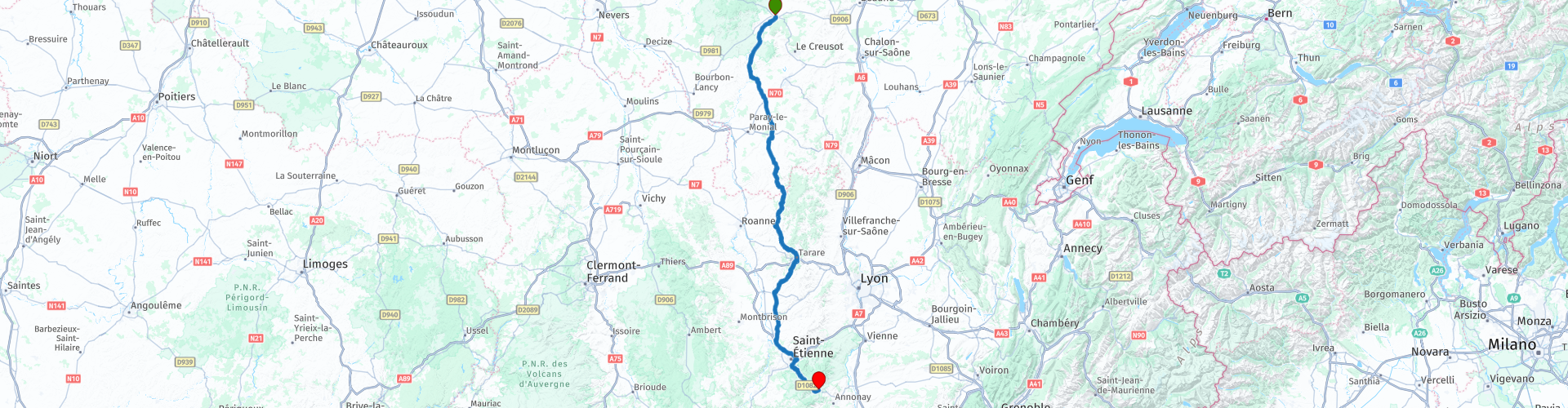
The starting point is in Autun, because it was the end of the approach route from northern France. (see also this series route number 2 MGT2 02 Burgundy Mesnil Saint Pere Bar du Seine Autun).
The original route starts west of Autun on the N81, but we leave it for what it is and we drive through the village and take the D46, a nice narrow and winding road through the meadows. After about 16km we arrive in Étang-sur-Arroux (RP5), where we return to the original route and continue on the D994 through the friendly landscape from South Burgundy to Toulon-sur-Arroux (RP6).
We turn left and then follow the D985 and drive via Perrecy-les-Forges to Charolles (RP7). Originally the white Charolais cows come from this place, which you see a lot in France.
The next city is La Clayette (RP8) with a 14th-century castle “La Château de La Clayette, which houses a car museum with many fantastic collector's models. Entry to the museum is free for collectors. It should also be noted that all vehicles shown are for sale.
When we leave the city again, the road starts to swing a bit more and we drive in a beautiful, hilly area with many nice curves. The road goes through different small towns such as Chauffailles (RP13), Cours-la-Ville (RP18), Thizy-les-Bourgs (RP19), Amplepuis (RP21) and finally ends in Tarare (RP22).
Due to the considerable increases and decreases you sometimes have very nice views on this part. You regularly drive through dense tunnels of trees and it gets cool around you. The area above Tarare itself is also a very nice touring area and is called "Monts de Tarare".
After Tarare we drive on the D60 via Panissières towards Feurs, again a beautiful road with many curves. From Feurs you can choose to continue quickly via the N82 (D1082) to St. Étíenne, but because this is a very busy, boring and straight part we drive an alternative route along the small D roads that are much nicer to drive and runs almost parallel.
Just before the D60 arrives on the D89 at the town of Salt-en-Donzy (RP23) we do not turn right towards Feurs, but we drive through this village and cross the D89 and continue on the D10. This road goes through Bellegarde-en-Forez and the water town of St. Galmier. Water was bottled here for the first time at the beginning of the last century. Shortly thereafter we arrive again on the N82 (D1082).
We are now just in front of St. Étienne, a large city of over 300,000 inhabitants and we have three options to leave this city behind as quickly as possible.
Option 1 is through the city, which is actually not an option if you want to do something in the city, eat or visit, the other two options are to stay on the N82 or and this is the fastest and best option is the four-lane A72- keep to the ring road and after about 14 km highway take the exit to the N82 (RP30) exit.
Now we enter the Parc Natural Régional du Pilat and drive the Col de la République to the end point of this route in Bourg-Argental. This is close to Annonay from where you have a good connection the routes to the south or to the Dróme and the Vercors, these are described in earlier reviews from Motorbike Guide Part 1.
There are a number of less fun parts in this route that run through or around cities, but despite that and because of the beautiful roads and the Col de la Republique, I rate this route with 4 **** Stars.


 Links
Links  Usage
Usage Want to download this route?
You can download the route for free without MyRoute-app account. To do so, open the route and click 'save as'. Want to edit this route?
No problem, start by opening the route. Follow the tutorial and create your personal MyRoute-app account. After registration, your trial starts automatically.  Disclaimer
Use of this GPS route is at your own expense and risk. The route has been carefully composed and checked by a MyRoute-app accredited RouteXpert for use on TomTom, Garmin and MyRoute-app Navigation.
Changes may nevertheless have occurred due to changed circumstances, road diversions or seasonal closures. We therefore recommend checking each route before use.
Preferably use the route track in your navigation system. More information about the use of MyRoute-app can be found on the website under 'Community' or 'Academy'.