De Kust van Normandie

This route was brought to you by:
RouteXpert Stijn Claus
Last edit: 15-02-2019
 Route Summary
 The route ends at the Mont Saint Michel.
This route can be driven with the motor, car as the mobile home.
 Share this route


Animation

Verdict


Duration
11h 8m

Mode of travel
Car or motorcycle

Distance
564.82 km

Countries

 RouteXpert Review
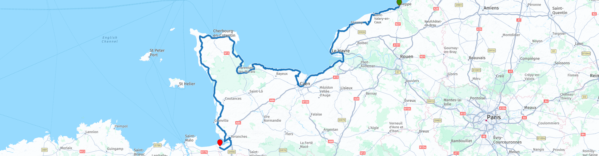
 This route starts in the historic seaside town of Dieppe. This city with its rich history of war can be easily and toll-free to reach. The city originated around the year 1000 when the river that flowed into the Channel there was called the Deep by the Vikings. Afterwards, Dieppe was the scene of the 90-year war and an attack of the Allies took place on 19 August 1942.
From Dieppe we drive along the coast to Étretat. This town is best known for its L'aiguille, an excellent chalk cliff off the coast. Via a walking path on either side of the city you can see and admire the chalk cliffs. The view is phenomenal.
Le Havre is half an hour away. Le Havre is the largest city in Normandy and lies at the mouth of the Seine.
Because of the American bombing in September 1944, Le Havre was almost razed to the ground. The new city that emerged after the Second World War under the direction of the architect Auguste Perret was included in the World Heritage list by UNESCO in 2005.
From Le Harve we drive further south, we take a piece of motorway and cross the Seine via the Pont de Normandie. With a total length of 2,143.21 m, this bridge is the longest of its kind in Europe and was even the longest in the world at the time of opening.
On the other side of the bridge, Honfleur is a picturesque fishing village with picturesque fishing port.
From Honfleur we continue along the coast to the mouth of the river Orne. There we curve 15 kilometers inland towards Caen.
Caen is the third city of Normandy. It was the capital of the former Basse-Normandie region. The city has a rich history and numerous historical sites. Just outside the center is the Memorial of Caen located. This peace monument is built on the foundations of an old German command bunker from the Second World War.
When we leave Caen we drive again towards the sea and arrive at Juno Beach. This is one of the five landing sectors on the beaches of Normandy during the Allied landing during the Second World War. Juno Beach was assigned as landing zone to the Canadian 3rd infantry division, the British 2nd armored brigade and a unit of commands from the British Royal Marines.
Then we pass at the Mulberryhaven of Arromanches-les-Bains and the battery of Longues-sur-Mer. Both war monuments can be viewed freely.
Via Ohama beach and the Normandy American Cemetery and Memorial, an American military cemetery and monument in memory of the American soldiers who fell at the landing in Normandy during the Second World War, we arrive at Point du hoc.
Pointe du Hoc is the most impressive relic of the Second World War along the Normandy coast. In the Second World War this point was covered by German bunkers and cannons. On 6 June 1944 this rock was climbed by the US 2nd Ranger battalion. 225 men would land on the beach and had to destroy the guns.
The site is still littered with deep craters like a lunar landscape. Between these craters, which are caused by shelling of the Allies, are still broken parts of the German bunkers. Some of these bunkers are still fully or partially standing. A memorial and museum has been erected, dedicated to the bloody battle that has taken place.
After the last landing beach, Utah beach, we make a detour on the Normandy peninsula. Via the largest city of Cherbourg-en-Cotentin in the north of the peninsula we bow again and drive towards the final destination of these routes. Le Mont Saint Michel.
The Mont Saint-Michel is a small, rocky tidal island at the mouth of the Couesnon. The granite massif of Mont Saint-Michel was crowned with a medieval abbey. On the spire of the abbey church, since 1898, there is a statue of Saint Michael who stands out one hundred and seventy meters above the bay. The island lies about 1 kilometer from the coast at the place Avranches in Normandy. The island: it was accessible by land at low tide, but at high tide it was surrounded by water. Nowadays there is a narrow bridge, with a shuttle service, to the island. The Mont Saint-Michel, with its staircases, is only accessible to pedestrians.


 Usage
Usage Want to download this route?
You can download the route for free without MyRoute-app account. To do so, open the route and click 'save as'. Want to edit this route?
No problem, start by opening the route. Follow the tutorial and create your personal MyRoute-app account. After registration, your trial starts automatically.  Disclaimer
Use of this GPS route is at your own expense and risk. The route has been carefully composed and checked by a MyRoute-app accredited RouteXpert for use on TomTom, Garmin and MyRoute-app Navigation.
Changes may nevertheless have occurred due to changed circumstances, road diversions or seasonal closures. We therefore recommend checking each route before use.
Preferably use the route track in your navigation system. More information about the use of MyRoute-app can be found on the website under 'Community' or 'Academy'.

Normandy
About this region
Normandy (/ˈnɔːrməndi/; French: Normandie [nɔʁmɑ̃di] (About this soundlisten); Norman: Normaundie; from Old French Normanz, plural of Normant, originally from the word for "northman" in several Scandinavian languages)[2] is a geographical and cultural region in Northwestern Europe, roughly coextensive with the historical Duchy of Normandy.
Normandy comprises mainland Normandy (a part of France) and the Channel Islands (mostly the British Crown Dependencies). It covers 30,627 square kilometres (11,825 sq mi).[3] Its population is 3,499,280. The inhabitants of Normandy are known as Normans,[1] and the region is the historic homeland of the Norman language. Large settlements include Rouen, Le Havre and Cherbourg.
The cultural region of Normandy is roughly similar to the historical Duchy of Normandy, which includes small areas now part of the departments of Mayenne and Sarthe. The Channel Islands (French: Îles Anglo-Normandes) are also historically part of Normandy; they cover 194 square kilometres (75 sq mi)[4] and comprise two bailiwicks: Guernsey and Jersey, which are British Crown Dependencies.
Normandy's name comes from the settlement of the territory by Vikings ("Northmen") starting in the 9th century, and confirmed by treaty in the 10th century between King Charles III of France and the Viking jarl Rollo. For four hundred years following the Norman conquest of England in 1066, Normandy and England were linked by having the same person reign as both Duke of Normandy and King of England.
Read more on Wikipedia
Normandy comprises mainland Normandy (a part of France) and the Channel Islands (mostly the British Crown Dependencies). It covers 30,627 square kilometres (11,825 sq mi).[3] Its population is 3,499,280. The inhabitants of Normandy are known as Normans,[1] and the region is the historic homeland of the Norman language. Large settlements include Rouen, Le Havre and Cherbourg.
The cultural region of Normandy is roughly similar to the historical Duchy of Normandy, which includes small areas now part of the departments of Mayenne and Sarthe. The Channel Islands (French: Îles Anglo-Normandes) are also historically part of Normandy; they cover 194 square kilometres (75 sq mi)[4] and comprise two bailiwicks: Guernsey and Jersey, which are British Crown Dependencies.
Normandy's name comes from the settlement of the territory by Vikings ("Northmen") starting in the 9th century, and confirmed by treaty in the 10th century between King Charles III of France and the Viking jarl Rollo. For four hundred years following the Norman conquest of England in 1066, Normandy and England were linked by having the same person reign as both Duke of Normandy and King of England.
View region
 Statistics
  15
15Amount of RX reviews (Normandy)
 18654
18654Amount of visitors (Normandy)
 1528
1528Amount of downloads (Normandy)
 Route Collections in this region
 3 day mini break through Brittany and Normandy
The overnight ferry crossing from Plymouth to Roscoff is a relaxing way to begin your 3 days of sightseeing in North West France. Touring the coasts and countryside of Brittany and Normandy, you'll discover beautiful sandy beaches, tiny fishing ports, bustling market towns and iconic and historical sites. Don't forget to sample Brittany's renowned seafood and delicious sweet and savoury pancakes, or Normandy cider and of course their 'hard to say no to' apple brandy, Calvados .
Day 1 takes you along the beautiful and rugged coast to Mont St Michel, a World Heritage site, visible for miles around. This is a wonderful place at any time of year, although be prepared for it to be very busy in summer. Your first hotel is just 30 minutes further along the coast at Hôtel Ibis Avranches Baie du Mont Saint-Michel. Other hotels are nearby and links for this hotel and your second night at Port en Bessin are in the individual route reviews.
Day 2 takes you first to Bayeux, world famous for its astonishing tapestry depicting the Norman Conquest of England in 1066, remarkable as a work of art and important as a source for 11th-century history. Bayeux also has a picturesque old quarter, WW2 museum and cathedral worth visiting (park motorcycles next to cathedral).
Then you can take in the sobering atmosphere at Pegasus Bridge, liberated by the British 6th Airborne Division glider unit, a full size replica of a Horsa glider shown in the picture above is on display, and the tale of the men it transported gives you a remarkable insight into the scale, ferocity and poignancy of Operation Overlord. Arromanches' Mulberry Harbour (Port Winston) and the gun emplacements dotted along the coast that you'll visit are reminders of the combats that took place here over 70 years ago. A great night is guaranteed at your second hotel in the fishing port of Port en Bessin where you can sample local cider (cidre) some of the freshest seafood available, fine wine, and finish off with some local calvados.
Day 3 tells the American story of D-Day with visits to Omaha and Utah beaches, various museums and the first town in France to be liberated during operation Overlord - Sainte-Mère-Eglise where an effigy of private John Steele dangles by his parachute from the church steeple.
Your return to the UK is via Cherbourg, to either Poole or Plymouth depending on the time of year, most sailings are around 17:00 hrs. Details from Brittany Ferries can be found in the link in the first review.
This is a great mini tour that'll give you a good glimpse of what this part of northern France has to offer and will leave you wanting to return.
View Route Collection
The 10 most downloaded routes in France from RouteXpert Catherine De Groote
Hello and welcome to this collection of the Top 10 MyRoute app downloaded routes in France.
A great new event will be announced soon, where all of these routes can be driven.
Download them all now and place them in a new "Top 10" folder so that you always have them at hand.
If you are going to drive one of these routes in the meantime, track them with the MRA Mobile App or with MRA Navigation. Take some photos (moments) along the way as they will come in handy.
Create a travelogue of your Top 10 driven routes and add the recorded track to it.
There will also be some great prizes on offer, so keep an eye on the MRA-RouteXperts page and your email.
View Route Collection