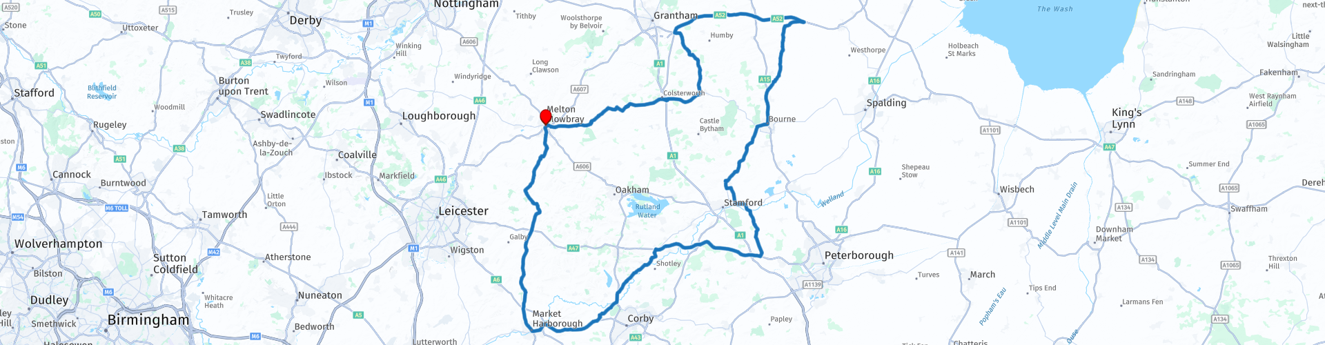
Round tour from Melton Mowbray Via Market Harborough and Bourne

This route was brought to you by:
RouteXpert Paul Taylor
Last edit: 19-09-2023
 Route Summary
 This route easily deserves 4**** stars because the roads, scenery and attractions are all Very Good.
 Share this route


Animation

Verdict


Duration
5h 19m

Mode of travel
Car or motorcycle

Distance
191.92 km

Countries

 RouteXpert Review
 Melton Mowbray pork pie Mary Dickinson (1768 to 1841) was considered the originator of the hand raised Melton Mowbray pork pie; Mary is credited with using the first wooden dolly to raise a pastry case. Mary’s method has stood the test of time and she is the reason the Melton Mowbray pork pies we all know and love, look the way they do. The pork pie industry originated about the year 1831 from in a little bakery and confectionary shop in Leicester Street, owned by a gentleman by the name of Edward Adcock.
In 1851 at the height of Britain’s Industrial Revolution John Dickerson (Marys Grandson) rented a shop in Nottingham Street making his Gramma’s pork pies and in 1880, John later took under his wing a young apprentice by the name of Joseph Morris, hence saving him from the workhouse. They both seemed to work well together, so in 1886 without further ado John added Joseph’s name to the business, this resulted in the shop name being changed to Dickerson and Morris, the shop was later bought in 1901, “Ye Olde pork pie Shoppe” it is still there today and is now the oldest pork pie bakery in the town.
In 2009, the Melton Mowbray pork pie was granted Protected Geographical Indication (PGI) status by the EU, recognising its historical, cultural, and culinary importance. What this means is it guarantees a product's characteristics or reputation, authenticity, and origin, so it protects the product name from misuse or imitation. In short to make Melton Mowbray pork pies they must be made within a certain geographical location.
Originally these pies were made for aristocratic gentlemen, as it was the traditional centre of English foxhunting who had come up for the hunt. They would put them in their saddlebags and eat them while they were out. They were very tasty, filling and eating them would not disrupt the hunt for too long. The black and scarlet hunting coats worn where made traditionally from Melton cloth, of wool that is woven in a twill form. It is thick, due to having been well fulled, which gives it a felt-like smooth surface, also with good weatherproof qualities.
Melton Carnegie Museum opened its doors for the first time in 1977, it is housed in Melton’s former Carnegie Library that was built in 1905 and showcase’s the history of Melton and the people who have lived and worked here from the Bronze Age to the present day. The museum is in the centre of Melton Mowbray, within easy walking distance of the marketplace and is free entry. There is free designated motorcycle parking available at Wilton Road, Chapel Street and St Mary's Way car park.
St Marys Church is one of six churches that are in the Melton Mowbray area, dating back mainly from the 13th – 15th centuries with some parts dating back further to Norman times - 1170. It has been described as "one of the finest parish churches in Leicestershire". It is built on a plan more usual for cathedrals with its grand cruciform church with isle transepts (one of only five in the country) normally found in a cathedral and a crossing tower with 100ft (30m) tower of scrubbed limestone that has dominated the town for centuries. The belfry since 1802 only had six bells but now contains ten bells, with the earliest one dating back to the fourteenth century.
Anne of Cleves building in Burton Street, next door to St Mary's Church it began its life in EST. 1384 and is now one of Melton's oldest surviving pubs, with original features still showing from the early fourteenth century. It was originally home to fourteen chantry monks who ministered to the leapers at the hospital, it was set up by Roger de Mowbray, the building including the lands of the Priory of Lewes was passed over to Anne of Cleves after the Dissolution as part of her divorce settlement from King VIII.
The Crosses these could be found sited all around Melton near the marketplace, there was six originally recorded. The Corn Cross, Butter Cross, Sheep Cross, Sage Cross, Thorpe Cross and Kettleby Cross. The corn market was held on Cornhill, at the top of the High Street or Merridine Street, as it was previously called and stood in the centre of the roadway where around it was the corn market. All the original crosses were removed or destroyed during the Reformation and other iconoclastic periods, or to make room for traffic or other development. So, the Corn Cross that can be seen today is a modern version that was erected in 1996 to replace the earlier medieval one. The same as the Butter Cross this was erected in 1986 to commemorate the 900th anniversary of the Domesday Book in which "Medeltone" Market is recorded, these are the only two that remain.
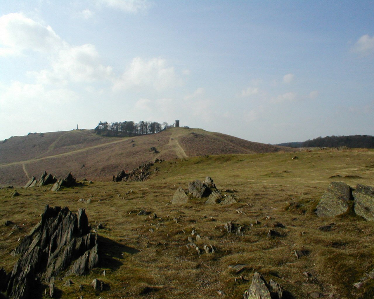
Shortly after leaving Melton Mowbray on the B6047 to Market Harborough this stretch of road is known locally as the “Big Dipper” for reasons that will soon become apparent with its undulating rise and fall of the road through the lovely Leicestershire countryside. There is also the first of many route options by continuing Straight onto Burrough Road then Melton Road for approximately 3.5 miles you can visit one of the most striking, prominent and historic features in the landscape of eastern Leicestershire. This well-preserved Iron Age hillfort that dramatically crowns a steep-sided promontory of land reaching 690ft (210m), with superb views and ready-made arena. The site is free and there is off road parking for a fee of £2.50 a day at the ticket machine.
With the “Big Dipper” behind you it is a brief stop in Market Harborough just in the county of Leicestershire, it was first established as a small village built by the Anglo Saxons during the 5th and 11th century. With plenty of free parking why not take some time to stroll around this quintessential market town, have some light refreshments and soak up some of the town’s history, culture and delicious food, be sure not to miss the amazing old grammar school perched high on its stilts that was founded in the 1607 to educate the poor children, St Dionysius an Anglican Church with its stunning stained glass windows and the Harborough Museum with free entry that celebrates the towns long history as a centre of trade and industry in the heart of the Welland Valley at the crossroads between Leicestershire and Northamptonshire.
Leaving Market Harborough, we head out onto the B670, there is a route option here at the junction with the A6003, turn right onto Main Street to visit the famous Rockingham Castle set on a hill overlooking five counties with some stunning views, built by William the Conqueror. The Castle was a royal residence for 450 years. In the 16th Century Henry VIII granted it to Edward Watson and for 450 years it has remained a family home. There is an admission fee that includes your parking, it is only open seasonally so do check times before you visit.
Further on the B672 there is also another route option, turn Left onto Gretton road and travel for 1 mile, here you can visit Lyddington Bede House, an historic house in the county of Rutland, England. The existing Grade I listed building is a part of a former palace of the Bishops of Lincoln, in 1600 it had passed to Sir Thomas Cecil, son of Queen Elizabeth’s chief minister, who converted it into an almshouse for 12 poor ‘bedesmen’ over 30 years old and two women (over 45), all free of lunacy, leprosy or the French pox. Situated next to St Andrew's Church in the picturesque ironstone village of Lyddington. It is now owned and run by British Heritage, so there is a £7 entrance fee, unfortunately there is also no onsite parking, so visitor have to park on the street.
Back on the B672 you see the Welland Viaduct come into view in the distance, this viaduct goes over the river Welland and both the B672 and Seaton Road, so it is also sometimes referred to as the Harringworth Viaduct or Seaton Viaduct. It is the longest masonry viaduct across a valley in Britain and took 13 months to construct using 30 million bricks. At a staggering 3825ft (1166m) long it certainly makes an impact on the landscape around it, with its 82 arches each with a span of 40ft (12m) and stands at 60ft (18m) high. It was built in 1878 and is now a Grade II listed building. The viaduct lies on the Oakham to Kettering Line and carries the twin-track non-electrified line between Corby and Manton Junction, where it then joins the Leicester to Peterborough line. There is a convenient stopping point for a photo opportunity in the tarmac layby on the opposite side of the road, where you can stand in ore and take in this monumental construction.
From here it is approximately a 30-mile ride on roads with lovely long sweeping corners, until the next stop in the town of Bourne. This town lays on the eastern slopes of the limestone Kesteven Uplands, on the southern edge of Lincolnshire bordering the fens. The earliest record of the town again was in the Doomsday book, in which it is recorded as Brune this is derived from an Anglo-Saxon word Brunna (Stream). The more modern name it was known by was Bourn, this was later changed in 1893 when the “e” was added by the post office to stop confusion with a similar named place in Cambridgeshire. It is believed at some point it became a Roman settlement as vast amounts of Roman coins have been found in the town location. It is most famously known for Bourne Eau this can be found in Wellhead Gardens where it rises up from an artesian spring, this is fed from a limestone aquifer some 165ft (50m) below the surface, so would have been of great interest to settlers as a drinking water resource, which now provides, both locally and Spalding with water. This spring then goes into a short river that was once used to power three water mills, it then flows in an easterly direction to join the river Glen at Tongue End. This is also an ideal opportunity to stop for some lunch or refreshments where there are a few cafes to choose from. Other recommended attractions include the jewel of Bourne Architecture, Red Hall built in 1605 an Elizabethan Hall, built with local red bricks that give its name, Tudor Cinema now a Chinese restaurant on North Street that opened its doors for the first time in 1929, Smiths store that’s been established nearly 150 years that in 2001 was converted into a pub but still retains Its original façade. There are several famous people that were born in Bourne these include Raymond Mays who lived there all his life, he was famous for motor car racing, Robert Bourne who it is claimed was the first person to ever write in English, William Cecil he was Lord High Treasurer to the Queen and Frederick Worth, who was the founder of the Paris Fashion House. The town also boast an outdoor Lido one of only a few hundred that are left now in the country. To really get a full appreciation of the history of Bourne you would be best to visit Bourne Heritage centre with free entry, it is about 656ft (200m) from the market on South Street. But please do check the opening times as they are only open at weekends, free parking can be found just off south street for all the attraction.
After Bourne we continue northwards for a short while before heading westerly and heading back towards Melton Mowbray. After coming off the A52 onto the B1176, this is the infamous Bitchfield Bends where the road meanders through the South Kesteven district in the heart of the Lincolnshire countryside. At Corby Glen it is then onto the B676 with its superb wide right and left angle sweeping corners. Approximately 6 miles before you arrive back at Melton Mowbray there is one final route option by taking the next left onto Wymondham Road and following for 1.7 miles you can visit a local attraction. Wymondham Windmill was built with local ironstone over 200 years ago, this historic five story flour mill with an ogee cap, fantail and originally with six sails. Set in seven acres of land where visitors are free to explore, with its very own tearoom that sells hot food and you can also buy fresh milled flour, there are a host of bespoke shops and ample free parking also onsite.
The route finishes in the Wilton Road carpark in Melton Mowbray.


 Links
Links  Usage
Usage Want to download this route?
You can download the route for free without MyRoute-app account. To do so, open the route and click 'save as'. Want to edit this route?
No problem, start by opening the route. Follow the tutorial and create your personal MyRoute-app account. After registration, your trial starts automatically.  Disclaimer
Use of this GPS route is at your own expense and risk. The route has been carefully composed and checked by a MyRoute-app accredited RouteXpert for use on TomTom, Garmin and MyRoute-app Navigation.
Changes may nevertheless have occurred due to changed circumstances, road diversions or seasonal closures. We therefore recommend checking each route before use.
Preferably use the route track in your navigation system. More information about the use of MyRoute-app can be found on the website under 'Community' or 'Academy'.
East Midlands
About this region
The East Midlands is one of nine official regions of England at the first level of NUTS for statistical purposes. It consists of Derbyshire, Leicestershire, Lincolnshire (except North and North East Lincolnshire), Northamptonshire, Nottinghamshire and Rutland. The region has an area of 15,627 km2 (6,034 sq mi), with a population over 4.5 million in 2011. The most populous settlements in the region are Derby, Leicester, Lincoln, Mansfield, Northampton and Nottingham. Other notable settlements include Boston, Chesterfield, Corby, Grantham, Hinckley, Kettering, Loughborough, Newark-on-Trent, Skegness, Wellingborough, and Worksop.
Relative proximity to London and its position on the national motorway and trunk road networks help the East Midlands to thrive as an economic hub. Nottingham and Leicester are each classified as a sufficiency-level world city by the Globalization and World Cities Research Network.The region is primarily served by East Midlands Airport, which lies between Derby, Leicester and Nottingham.
Read more on Wikipedia
Relative proximity to London and its position on the national motorway and trunk road networks help the East Midlands to thrive as an economic hub. Nottingham and Leicester are each classified as a sufficiency-level world city by the Globalization and World Cities Research Network.The region is primarily served by East Midlands Airport, which lies between Derby, Leicester and Nottingham.
View region
 Statistics
  18
18Amount of RX reviews (East Midlands)
 24571
24571Amount of visitors (East Midlands)
 1763
1763Amount of downloads (East Midlands)
 Route Collections in this region
 The Ultimate 10 Day (North) UK Tour
Starting from and returning to Harwich ferry port, this tour follows the east coast of England up to the Highlands of Scotland and returns via the Lake District. It visits 6 of the UK's national parks and explores 2 islands and visits 2 James Bond 007 film locations.
Daily highlights.
Day 1, Harwich to Wells Next the Sea:
Southwold lighthouse, Cromer Crab lunch and sleeping on a Dutch barge.
Day 2, Wells Next the Sea to Middlesbrough:
Royal Sandringham Estate, Humber Bridge, a lap of Oliver's Mount, North York Moors National Park, Whitby Abbey the inspiration for Dracula.
Day 3, Middlesbrough to Dundee:
Tees Transporter Bridge, Angel of the North, Bamburgh Castle, Holy Island of Lindisfarne.
Day 4, Dundee to Inverness:
Cairngorms National Park, Balmoral Castle, Whisky Distilleries.
Day 5, Inverness to Ullapool:
Exceptional Landscapes, Falls of Shin, Loch Drumbeg Viewpoint, Kylesku Bridge.
Day 6, Ullapool to Dornie:
Kinlochewe viewpoint, Applecross Pass, Isle of Skye.
Day 7, Dornie to Keswick:
Eilean Donan Castle (007), Glencoe Pass, Glen Etive (007), Loch Lomond and Trossachs National Park.
Day 8, Keswick to Kendal:
A tour of the Lake District National Park visiting 6 of the best passes including Wrynose Pass and Hardknott Pass and 7 of the great lakes including Ullswater and Windermere.
Day 9, Kendal to Matlock:
Yorkshire Dales National Park, Ribblehead Viaduct, Peak District National Park, Snake Pass, Matlock Bath (motorcycle Mecca).
Day 10, Matlock to Harwich:
Heckington Windmill, Moulton Windmill, Dutch Quarter in Colchester.
By starting from Harwich, this tour avoids the traffic congestion of the south east and London making it perfect for European visitors wanting to see some of the best landscapes and sights that the north of the UK has to offer.
The cost of the ferry from Hoek Van Holland to Harwich return for motorcycle and rider costs £139.00 (163.51 Euro) (in 2019) which includes a cabin on the outward leg.
Where possible, motorways have been avoided and scenic routes are used every day.
Enjoy.
View Route Collection
Top 10 Downloaded UK routes by RouteXpert Nick Carthew
Hello and welcome to this collection of the Top 10 MyRoute app downloaded routes in the UK.
There will be a great new event to be announced soon, where all these routes can be ridden.
Download them all now and place them in a new "Top 10" folder, so that you always have them at hand.
If you are going to drive one of these routes in the meantime, track them with the MRA Mobile App or with MRA Navigation. Take some photos (moments) along the way as these will come in handy.
Create a travelstory of your Top 10 driven routes and add the recorded track to it.
There will also be some great prizes on offer, so keep an eye on the MRA-RouteXperts page and your email.
View Route Collection