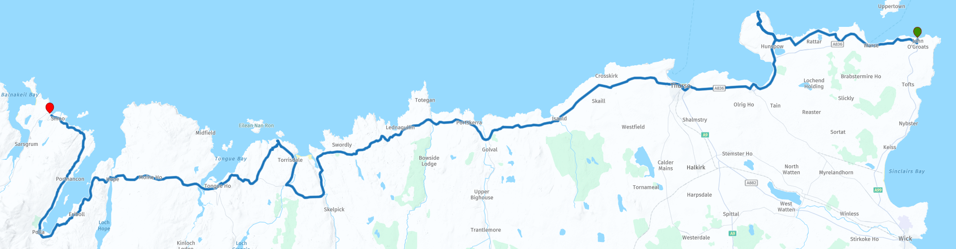
John O Groats Dunnet Head Kyle of Tongue and Durness

This route was brought to you by:
RouteXpert Nick Carthew - (MRA Master)
Last edit: 01-04-2025
 Route Summary
 Excellent landscape, roads and very good attractions make this a 5***** star route.
 Share this route


Animation

Verdict


Duration
6h 20m

Mode of travel
Car or motorcycle

Distance
168.42 km

Countries

 RouteXpert Review
 This route starts from John O' Groats and we rode it in May 2016 as the start of our return leg of our Lands End to John O' Groats trip. The land and seascapes across the top of Scotland are breathtaking, some of the best that the Highlands of Scotland has to offer.
Just along the coast from John O'Groats is Dunnets Head, this is the most northerly point on mainland GB so we had to 'bag it' and this route does too! There are some great views from Dunnet Head viewpoint.
Fuel and shops are thin on the ground in this part of Scotland so it is advisable to fill up at Thurso, we also bought some provisions for a picnic and our supper in the Lidl supermarket at Thurso. We had booked to stay the night at a bunkhouse in Durness and although there is a shop and a 24hr fuel station there, we wanted to make sure we had enough supplies (wine and beer) as Durness is quite remote, I would advise you to do the same.
This route is all about the scenery and the further west you travel the more remote and beautiful the scenery becomes. We went in May and the roadsides were awash with bright yellow Gorse, filling the air with the smell of coconut, that coupled with the bright blue sky, white sandy beaches and turquoise sea, we could have been in the Caribbean.
It's a joy to use the ancient cast iron bridge to cross over the River Naver on the way to a picnic stop at Coldbackie Beach. The beach and coastline are beautiful making this an ideal place for a break.
Next is a spectacular crossing of the Kyle of Tongue by causeway and bridge. Perhaps Tongue's most significant moment in history came in early 1746 when the ship Hazard, en route for Inverness, fled into the Kyle of Tongue to evade HMS Sheerness, a Royal Navy frigate. The Hazard (aptly named!) was carrying a large quantity of gold coins to fund Bonnie Prince Charlie's rebellion and its crew took the gold ashore in an effort to carry it overland to its destination. The Mackays were supporters of the government and their forces caught up with the crew of the Hazard next morning at Lochan Haken, near the southern end of the Kyle of Tongue. The gold was thrown into the loch by the crew before they were captured, though most of it was later recovered by the government. What adds significance is the story that when word of this reached Bonnie Prince Charlie, he sent 1,500 of his men north in an effort to regain the gold, and they were defeated en route. Some believe that had these men still been available a short time later at the Battle of Culloden the outcome might have been different. It is more likely that as Culloden was so one-sided the missing troops would have made little difference, but who can say for sure?
Now it's on to Loch Eriboll. It was here at the end of WW2 that 33 U-boat commanders surrendered their U-boats. In the space of just 15 days from May 10th to May 25th 1945, the 10-mile long loch turned into the biggest single gathering of the German submarine fleet anywhere in the world. The surrender of the subs – the wolf pack that terrorised the north Atlantic shipping lanes – in Loch Eriboll was one of the strangest episodes at the end of the war.
Durness and the Lazy Crofter Bunkhouse are just a short ride from the mouth of Loch Eriboll.
It was our first experience of a hostel style evening and I must say, it was very pleasant, we sat out on the veranda swapping tales with other travellers until it got dark, it was almost midnight as the sun sinks very slowly this far north.
Links for the hotel and bunkhouse are below as well as a link to a video I shot during our 2016 visit.
Enjoy


 Links
Links  Usage
Usage Want to download this route?
You can download the route for free without MyRoute-app account. To do so, open the route and click 'save as'. Want to edit this route?
No problem, start by opening the route. Follow the tutorial and create your personal MyRoute-app account. After registration, your trial starts automatically.  Disclaimer
Use of this GPS route is at your own expense and risk. The route has been carefully composed and checked by a MyRoute-app accredited RouteXpert for use on TomTom, Garmin and MyRoute-app Navigation.
Changes may nevertheless have occurred due to changed circumstances, road diversions or seasonal closures. We therefore recommend checking each route before use.
Preferably use the route track in your navigation system. More information about the use of MyRoute-app can be found on the website under 'Community' or 'Academy'.