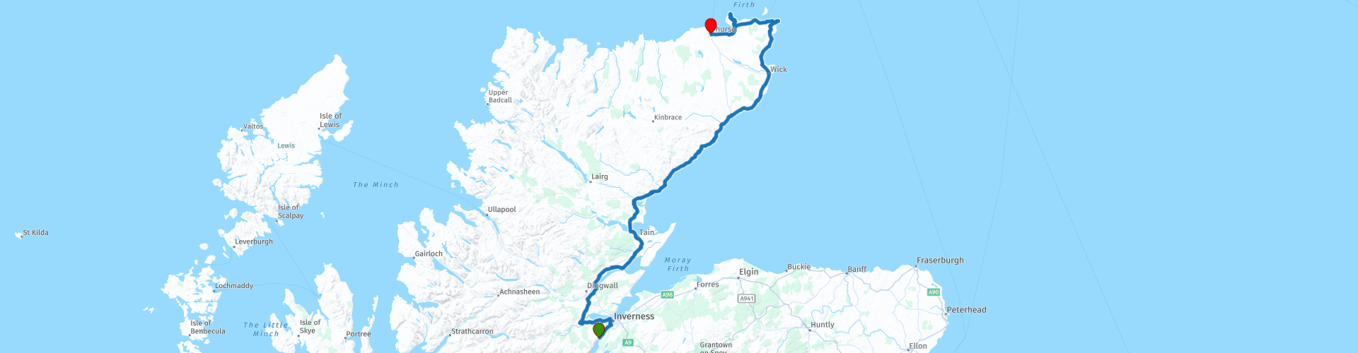
UK Scotland 04 Loch Ness to Thurso 280km svd

This route was brought to you by:
RouteXpert Serge van Driel - RouteXpert
Last edit: 27-01-2019
 Route Summary
  Share this route


Animation

Verdict


Duration
4h 23m

Mode of travel
Car or motorcycle

Distance
273.43 km

Countries

 RouteXpert Review
 Day 5: Loch Ness to Thurso. Today we go to the most Northeast point of the mainland of the UK and of Scotland of course. With clear weather you will soon see the Orkney Islands, as we look out from John O'Groat, Dunnet Head and the steep rock points at Duncansby Head.
But, before we get there, after breakfast we go to Kim to prepare the engine for departure, and we drive to Inverness, but immediately turn left to drive along the water of the Beauly Firth and after a quarter of an hour we pass a big motorcycle shop. , as far as I know, the last one we see until we get close to Fort William. If you need anything else, stop here. I bought a rain suit because my Rev'it was not (anymore) able to cope with the Scottish rain that we had received over us yesterday. With the good waterproof clothing it runs so fine in this somewhat humid and at times very fresh climate. Keep that in mind, put on an extra shirt too.
We continue the road to Wester-Balblair where we cross the River Beauly and immediately turn right to the North. At RP7 you have beautiful views and if we cross the Cromarty Bridge it is great left and right. Hopefully you drive here with cloudy but sunny weather. On the left is a narrow footpath and if it is quiet you can briefly stop here for some beautiful pictures. There you also get plenty of opportunity at RP9, in Slatburn, unfortunately we drove in a downpour so we did not stop and drove on to Dormoch Firth Bridge and then we are half an hour later at Dunrobin Castle, an impressive castle, located directly on the water. (RP13)
We have in the picturesque village of Brora warm our claws on pumpkin soup, and delicious sandwiches while we were allowed to dry inside and put our feet by the stove. Pumpkinsoup!
With recovered strength and fairly dry, even the gloves that had been dried on the GS cylinders for a while, could continue with it. TIP: when refueling, take a supply of those thin plastic gloves with you, every time you refuel. Put on these before you put on your motorcycle gloves, and you have warmer, drier hands and the dye from your (especially leather) glove does not get in your hands.
We follow the west coast up, and along the way are some castles, not all worth mentioning or visiting, but beautiful to see in passing. RP17 marks a gas station in Wick, and I recommend to refuel often above Inverness. Petrol stations are becoming scarcer, and especially if you have a small radius of action, it is advisable to refuel on time. This is possible here.
Duncansby Head, Lighthouse and striking, distinctive rocks. You have to stop by. RP19
Then the same way back and back to John o 'Groats, RP20, and as said the most Northeast part of "mainland Britain" and overland the furthest from the other extreme of the UK, Land's End (In another report I will tell me about my visit there)
We follow the Northern coast and we see the Orkneys, and we drive to Dunnet Head. With luck you see beautiful birds here and the characteristic "puffin" (puffin) also occurs here.
Tomorrow we will pass Puffin Cove, now first a picture at the Dunnet Head
That was the last stop today, and we drive into Thurso and find a small (very small ....) but excellent B & B. Parking can be on the other side, behind a gate that is locked. More than enough food and drinks in the neighborhood, so a pleasant walk through the town and satisfied to bed.
Watch your head! Trusten, until tomorrow


 Usage
Usage Want to download this route?
You can download the route for free without MyRoute-app account. To do so, open the route and click 'save as'. Want to edit this route?
No problem, start by opening the route. Follow the tutorial and create your personal MyRoute-app account. After registration, your trial starts automatically.  Disclaimer
Use of this GPS route is at your own expense and risk. The route has been carefully composed and checked by a MyRoute-app accredited RouteXpert for use on TomTom, Garmin and MyRoute-app Navigation.
Changes may nevertheless have occurred due to changed circumstances, road diversions or seasonal closures. We therefore recommend checking each route before use.
Preferably use the route track in your navigation system. More information about the use of MyRoute-app can be found on the website under 'Community' or 'Academy'.