10 Bideford to Marlborough via Cheddar Gorge

This route was brought to you by:
RouteXpert Nick Carthew - (MRA Master)
Last edit: 14-08-2023
 Route Summary
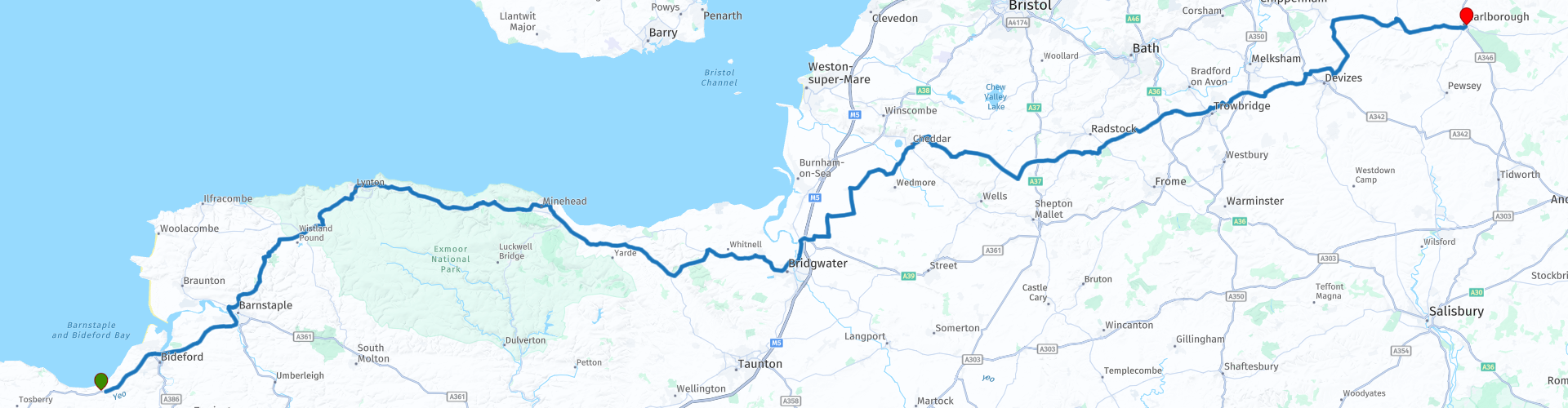
 This route starts the journey back to Dover and travels east across Exmoor, over the Quantock Hills, across the Somerset Levels, through Cheddar Gorge and on to Avebury, recognised as a World Heritage Site for it's outstanding Neolithic and Bronze Age landscape.
A ford crossing a river at Allerford can become swollen with heavy rain, only cross if you feel safe.
This route has good roads with excellant scenery and attractions earning it the full 5***** stars.
 Share this route


Animation

Verdict


Duration
7h 27m

Mode of travel
Car or motorcycle

Distance
258.51 km

Countries

 RouteXpert Review
 The first 60 miles travel on the delightful A39 road, often quoted as one of the best riding roads in the south west of England and once you have ridden this route, you will see why it received that accolade.
The route starts by crossing the two major rivers of North Devon, first the Torridge at Bideford and then the Taw at Barnstaple, it then heads to Exmoor on a wonderfully winding road. Blackmoor Gate is known as the western gateway to Exmoor and was once a station on the former Lynton and Barnstaple Railway. You can see a short section of this legendary railway a few miles further on at Woody Bay station, and if you are lucky, you might see one of the narrow gauge steam locomotives.
The Lynton & Barnstaple Railway Association was formed in 1979. Woody Bay Station was purchased by the Lynton and Barnstaple Railway Company in 1995 and, after much effort, a short section of railway reopened to passengers in 2004. This was extended to over a mile in 2006, with steam and diesel-hauled trains running between Woody Bay and the new, temporary terminus at Killington Lane. Originally opened in 1898, and closed in 1935; what you can see today at Woody Bay is just the beginning of an exciting project to rebuild one of the world's most famous and picturesque narrow-gauge railways.
At Barbrook, you turn off of the A39 and follow the beautiful West Lyn river, which rises high on Exmoor and joins the East Lyn at Lynmouth. The upper reaches have been designated as a Site of Special Scientific Interest, because of the geomorphological landforms created in the 1952 Lynmouth flood.
The previous route (09) in this road trip visits Lynmouth and the review of that route contains further information for Lynmouth. You rejoin the A39 and head up Countisbury Hill, the views along the cliffs and across the Bristol Channel are breathtaking and they carry on until you reach Porlock Hill.
At 25% or 1 in 4, Porlock Hill is reputably the steepest 'A' road in England. It descends approximately 1.300 ft in just 2 miles and has 2 180° hairpin bends just to add to the enjoyment!
Porlock village sits in the wide and fertile Porlock Vale, a little inland from Porlock salt marsh and the shingle ridge. The High Street meanders through the village with a wide range of quality independent shops. The medieval church of St Dubricius sits in the centre of the village.
A few miles further on from Porlock is the small, pretty village of Allerford, home to the iconic and historic packhorse bridge and ford river crossing.
This bridge was a vital trade artery for the whole region and is constructed so that packhorses can cross the river laden with goods. The parapets on either side of the bridge are low so as not to interfere with the overhanging loads on the horses’ backs. I imagine Exmoor ponies piled high and wide with wool on their way to the medieval yarn market in nearby Dunster crossing this cobbled bridge at Allerford. Wool from Exmoor Horn sheep was for a long-time the life-blood of Exmoor. Many roads and tracks were inaccessible by wagon and so the hardy Exmoor pony was called upon for transportation. You can ride through the River Aller using the ford and rejoin the route back on the A39.
The seaside town of Minehead comes next, you can park your motorcycle on the promenade opposite the West Somerset Railway, the longest standard gauge heritage steam railway in the world.
Minehead was once a busy port, trading in wool, coal and salt, but like many of the historic coastal towns, the trade has long stopped and Minehead like so many others rely almost entirely on tourism.
Leaving Minehead behind and rejoining the A39, high on the hill to your right is Dunster Castle. With 1,000 years of history the castle has plenty of great stories to tell. The last family to live here, the Luttrells, moved in in 1376 and out in 1976. Dunster Castle has commanded this outstanding location atop the tor since the Middle Ages. It is a perfect site for a castle – visually impressive and easily defended. The castle, owned by only two families, has been transformed through the ages from fortress to family home.
The route leaves the A39 again at Williton to travel over the Quantock Hills.
The Quantock Hills are an Area of Outstanding Natural Beauty (AONB), which means that its distinctive character, natural beauty and cultural heritage are so outstanding that it is in the nation’s interest to safeguard them. The area received its protected status in 1956. This precious and ancient place with its distinct cultural heritage and village communities is hugely valued locally as a native or adopted homeland and workplace, as well as a favoured educational, recreational and even spiritual resource. The first place in Britain to be designated An Area of Outstanding Natural Beauty was the land on and around the Quantock Hills which inspired the great poets of the Romantic Movement, Coleridge and Wordsworth to pen some of their finest verses. The pair, accompanied by Wordsworth’s sister Dorothy, would wander the woods, rolling hills and coastal paths for hours and in many ways much of what they wondered at has not changed.
Characterised by deep wooded valleys or "combes", open heath land and rich flora and fauna, the Quantocks is an exceptionally beautiful area to travel through.
Just before rejoining the A39 at Nether Stowey, you will pass by what looks like an insignificant hill, it is actually the remains of Stowey Castle. Stowey Castle was a Norman motte-and-bailey castle, built in the 11th century. The castle may have been destroyed during the 12th Century Civil War.
The route says a final farewell to the A39 when it reaches Bridgewater and crosses over the busy M5 motorway to take you onto the Somerset Levels.
The Internationally important Somerset Levels and Moors stretch from the clay-based coastal plains across peat-based Avalon Marshes to the foot of the Mendip Hills. Among the lowest, flattest areas in the UK, the Levels were once covered by sea apart from the curious mumps and mounds that rose above them as islands. Somerset is therefore ‘the land of the summer people’ as the rich grazing pastures of the Levels were only accessible in the drier months. To reach the grasslands from the ‘islands’, prehistoric people built raised wooden tracks, of which there is still evidence today. The most famous is the Sweet Track at Shapwick. The Romans tried managing the Levels but did not have as much success as the monks of Glastonbury. Dutch engineers eventually drained them in the 17th century but thankfully not until after King Alfred had used the marshes to escape the Vikings or English history might have taken a different turn. Still farmed and used for growing willow, the wetlands attract huge numbers of wading birds including the reintroduced Common Crane.
At the foot of the Mendip Hills is the town of Cheddar, famous for the cheese produced around here and the spectacular Cheddar Gorge that cuts its way through the limestone rock. I have suggested a lunch stop in Cheddar before travelling through the gorge, the Bath Arms Hotel is a great place to stop but there are numerous other places that will cater for all tastes.
Cheddar Gorge is not only one of Britain's most spectacular natural landmarks, but also an Area of Outstanding Natural Beauty (AONB) and a Site of Special Scientific Interest (SSSI).
The Gorge boasts awe-inspiring cliffs and extraordinary subterranean stalactite show caves, plus many fascinating secrets about our prehistoric ancestors. Excavated in the late nineteenth century, Gough’s cave is the largest of the show caves, widely considered as one of the finest in the country. The formation of this cave began over half a million years ago, when river water started dissolving the limestone rock. Our ancestors, the Horse Hunters of Cheddar Gorge, lived in Gough’s Cave 14,700 years ago, at the end of the last Ice Age. Archaeological evidence suggests they may have been cannibals, killing and eating their enemies!
Cheddar Man, a hunter-gatherer who lived around 10,000 years ago, is the oldest complete skeleton ever found in Britain. It’s thought that his tribe buried him in a special area of the cave to prevent his spirit passing to the land of the ancestors.
Leaving the gorge, the route remains in the Mendip Hills AONB for several miles and then travels east through open countryside to the village of Norton St Philip. Here you will find The George Inn, one of a number of establishments that claims to be Britain's oldest tavern. It was built in the 14th century and has been designated as a Grade I listed building. It was originally built as a wool store for Hinton Priory at nearby Hinton Charterhouse and to accommodate travellers and merchants coming to the annual wool fairs that were held in the village from the late 13th century until 1902. The building has been used as a setting for a number of films and TV shows and makes an excellent backdrop for a photo of your motorcycle.
A little further on and located on the banks of the River Frome that marks the border from Somerset and Wiltshire, you’ll find Farleigh Hungerford Castle, built to serve as a luxurious home for the Hungerford family. They rose to prominence through service to the Dukes of Lancaster but this loyalty cost them dearly during the Wars of the Roses. The castle was seized by Royalist forces during the Civil War. Started in the 14th century, the fortified mansion still has much for visitors to enjoy.
The market town of Trowbridge is next, county town of Wiltshire.
Long a market town, the Kennet and Avon canal to the north of Trowbridge played an instrumental part in the town's development as it allowed coal to be transported from the Somerset Coalfield and so marked the advent of steam-powered manufacturing in woollen cloth mills. The town was the foremost producer of this mainstay of contemporary clothing and blankets in south west England in the late 18th and early 19th centuries.
Close to the town of Devizes you will cross over the Kennet and Avon canal and see the series locks known as: Caen Hill Flight of Locks. Caen Hill is one of the longest continuous flight of locks in the country - a total of 29 locks with a rise of 237 feet over 2 miles with a 1 in 44 gradient for anyone who's counting! It truly is an inspirational feet of engineering.
Wiltshire is the county for white horses. There are or were at least twenty-four of these hill figures in Britain, with no less than thirteen being in Wiltshire, and another white horse, the oldest of them all, being just over the border in Oxfordshire. Most of the white horses are chalk hill carvings, and the chalk downs of central Wiltshire make it an ideal place for such figures. Of the thirteen white horses known to have existed in Wiltshire, eight are still visible and the route now visits two of them.
The first is the Devizes White Horse, the youngest of all Wiltshire white horses. It was carved into the hillside in 1999 to celebrate the millennium.
Just a few miles away is the Cherhill White Horse, the second oldest in Wiltshire and was made under the guidance of Dr Christopher Alsop of Calne in 1780, who gave instructions to a team of workers from a distance, using a megaphone!
The Cherhill horse can be seen to the left of the Lansdowne Monument. Built as an ‘eye-catcher’ by the 3rd Marquis of Lansdowne, the Lansdowne Monument is an iconic landmark that can be seen for miles around and was built in 1845 to commemorate Sir William Petty. It is not surprising that the Marquis of Lansdowne wanted to commemorate Sir William Petty, for his ancestor was a remarkable man. Born the son of a lowly cloth worker, Petty studied to become a physician and was appointed as Professor of Anatomy at Oxford. Oliver Cromwell made him Physician-General to his army in Ireland. While in Ireland he turned his hand to engineering and conducted the first meticulous land survey of the country. The Monument stands on the highest point of the National Trust's Calstone and Cherhill Downs estate, within the earthworks of Oldbury Castle, an Iron Age hillfort.
A short ride from Cherhill takes you to Avebury where you can step into the largest stone circle in the world, standing for over 4500 years, and the site of a host of archaeological excavations.
Forming part of the UNESCO World Heritage Site with Stonehenge, Avebury is the lesser-known of Wiltshire’s stone circles, despite being the largest in the world. The great stone circle dates from around 4,500 years ago and encloses part of the village. Visitors can wander freely amongst the stones within the stone circle. The end of the route is just 15 minutes from Avebury so take your time to enjoy some ancient history.
West Kennet Avenue leads you away from Avebury through an avenue of prehistoric standing stones raised to form a winding 1 1/2 mile ritual link between the pre-existing monuments of Avebury and The Sanctuary.
The route passes The Sanctuary that is close to the side of the A4 road. There is parking for you to have a closer look and read the information board. Begun in about 2500 BC, the Sanctuary was originally a complex circular arrangement of timber posts and standing stones. These components are now indicated by concrete blocks and posts. When archaeologists excavated the site in 1930 they found many objects such as flint tools, animal bones and pottery fragments, suggesting that Neolithic people were placing offerings in and around the standing posts. Later, in the early Bronze Age, the site was chosen for the burial of a teenage boy with a small Beaker pot. There are several Bronze Age burial mounds or barrows nearby.
The end of the route at Marlborough is just 5 miles from here.
The thriving town of Marlborough and the neighbouring pretty village of Manton are set in the stunning scenery of the North Wessex Downs Area of Outstanding Natural Beauty. There's countryside within 10 minutes walk of the High Street in almost any direction. The town has remained unspoiled, retaining its historic charm and is perfectly situated on the old Bath Road (built by order of the Kings of England) linking Bath to London - the Great West Way is a rich and enticing route for visitors to explore to this day. A favourite watering hole for coach & horses travellers in the past, Marlborough is a cosmopolitan destination today continuing to welcome visitors from all over the world.
I have chosen the Premier Inn as the accommodation for the end of this route but there are plenty of other forms of accommodation to choose from.
Enjoy


 Links
Links  Usage
Usage Want to download this route?
You can download the route for free without MyRoute-app account. To do so, open the route and click 'save as'. Want to edit this route?
No problem, start by opening the route. Follow the tutorial and create your personal MyRoute-app account. After registration, your trial starts automatically.  Disclaimer
Use of this GPS route is at your own expense and risk. The route has been carefully composed and checked by a MyRoute-app accredited RouteXpert for use on TomTom, Garmin and MyRoute-app Navigation.
Changes may nevertheless have occurred due to changed circumstances, road diversions or seasonal closures. We therefore recommend checking each route before use.
Preferably use the route track in your navigation system. More information about the use of MyRoute-app can be found on the website under 'Community' or 'Academy'.

South West
About this region
The points of the compass are an evenly spaced set of horizontal directions (or azimuths) used in navigation and geography. A compass rose is primarily composed of four cardinal directions—north, east, south, and west—each separated by 90 degrees, and secondarily divided by four ordinal (intercardinal) directions—northeast, southeast, southwest, and northwest—each located halfway between two cardinal directions. Some disciplines such as meteorology and navigation further divide the compass with additional azimuths. Within European tradition, a fully defined compass has 32 'points' (and any finer subdivisions are described in fractions of points).Compass points are valuable in that they allow a user to refer to a specific azimuth in a colloquial fashion, without having to compute or remember degrees.
Read more on Wikipedia
View region
 Statistics
  42
42Amount of RX reviews (South West)
 24541
24541Amount of visitors (South West)
 3732
3732Amount of downloads (South West)
 Route Collections in this region
 Great 6 day tour of Wales
This collection of 6 routes all pass through at least 1 of the 3 spectacular national parks of Wales'. Each park is unique and individual and the landscapes vary from the vast, remote and wide open moorland of the Brecon Beacons to the rugged mountains and glistening lakes of Snowdonia and the spectacular coastline of the Pembrokeshire coast. Each is a delight to travel through and these routes will take you to some of the best beauty spots.
There are some great attractions to visit too, as well as having more than it's fair share of fantastic castles and historic buildings, there is the worlds fastest zip line, a balcony road used for world rally stages, mysterious caves and magical waterfalls and a museum of land speed records. All of these can be seen on the routes in this collection.
Although each route in this collection is a separate stand alone route, they will all link up seamlessly to make a 6 day tour that you will remember. The tour starts and ends in Gloucester which can be easily reached in a day from any of the Channel ports.
Enjoy Wales.
View Route Collection
Top 10 Downloaded UK routes by RouteXpert Nick Carthew
Hello and welcome to this collection of the Top 10 MyRoute app downloaded routes in the UK.
There will be a great new event to be announced soon, where all these routes can be ridden.
Download them all now and place them in a new "Top 10" folder, so that you always have them at hand.
If you are going to drive one of these routes in the meantime, track them with the MRA Mobile App or with MRA Navigation. Take some photos (moments) along the way as these will come in handy.
Create a travelstory of your Top 10 driven routes and add the recorded track to it.
There will also be some great prizes on offer, so keep an eye on the MRA-RouteXperts page and your email.
View Route Collection