09 round tour of Exmoor from Bideford

This route was brought to you by:
RouteXpert Nick Carthew - (MRA Master)
Last edit: 24-10-2022
 Route Summary
 A spectacular tour of Exmoor National Park that takes in the vast open moorland, deep wooded valleys and stunning coastline. The route uses the Lee Abbey Toll road that has a charge of £2 per vehicle, trust me the £2 is worth it! Excellent scenery, very good roads and attractions earn this route 5***** stars.
 Share this route


Animation

Verdict


Duration
7h 17m

Mode of travel
Car or motorcycle

Distance
213.99 km

Countries

 RouteXpert Review
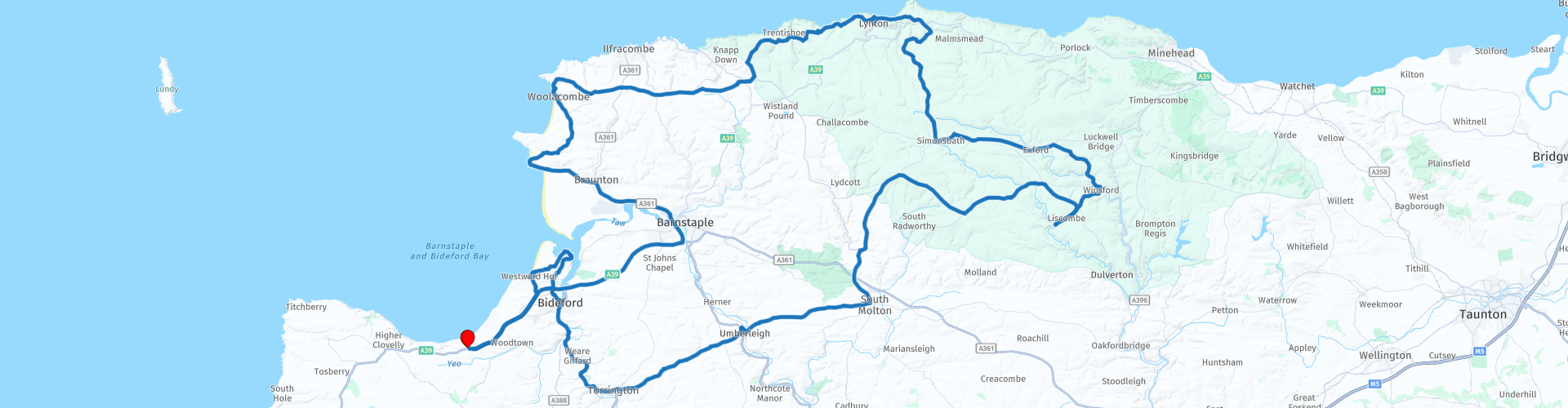
 This round tour from the Hoops Inn, near Bideford will take you high up onto the open moorland of Exmoor National Park.
There is a lot to see so my advice is to get an early start.
From The Hoops Inn a short ride takes you to the small port of Bideford where you can fill your tank.
Believe it or not, Bideford was once Britain’s third largest port and while it still has maritime connections, the silting up of the river has reduced the cargos to one or two ships every couple of months. They come to Bideford to export Ball Clay that is quarried further up the River Torridge.
The route follows the River Torridge under a canopy of trees for about 6 miles to the town of Great Torrington.
Great Torrington had strategic significance in the English Civil War. In the Battle of Torrington (1646), the Parliamentarians, led by Sir Thomas Fairfax, swept into the town and defeated Lord Hopton's forces. This marked the end of Royalist resistance in the West Country.
The B3227 from Great Torrington takes you on a very undulating road, known locally as The Roller Coaster road, and you'll see why when you travel on it. You'll cross over the River Taw at Umberleigh, the second of the two main rivers of North Devon alongside the River Torridge. They both meet at Appledore before emptying into Bideford Bay. The end of this route visits Appledore so you'll see where the two rivers converge.
After passing the market town of South Molton and over the main arterial A39 road the route steadily climbs up to the high moorland of Exmoor at Two Barrows, a height of 480 m, the highest point of the route. The views south from here are breathtaking and on a clear day you can see Dartmoor 30 miles away and on a very clear day Bodmin Moor 50 miles away. This area is known as Two Barrows (bizarrely) because of the four, yes four Bronze Age burial mounds which are known as barrows. This is also a good spot for any bird watchers, buzzards, kestrels, red kites and occasionally a hen harrier or hobby can be seen and this is just the birds of prey. The Two Barrows road marks the county border with Somerset to the north and Devon to the south.
A little further on you'll pass over a cattle grid and onto Withypool Common, another vast area of moorland where you are likely to see some ancient breed ponies.
The Exmoor pony is the oldest native pony breed in Britain and is currently listed as an endangered rare breed. Approximately 3,500 of these ponies survive worldwide, of which around 350 still live free on Exmoor. Keep your eyes open for them.
The road across the common descends to the pretty Exmoor village of Withypool where I have suggested a coffee stop at the tea rooms there. Withypool Tea Rooms is just a few yards from one of Exmoor's principle rivers, the River Barle. The tea rooms are a former fuel station that still have the old Shell fuel pumps outside, with the beautiful river alongside and the nostalgic feel of the tea rooms, it's no wonder that this is a very popular stopping place for motorcyclists and other travellers.
After your coffee, the route will take you to more open moorland as you cross Winsford Hill to Tarr Steps.
Tarr Steps is an ancient clapper bridge across the River Barle possibly dating back to 1000BC. It is a Grade 1 listed building and Scheduled Ancient Monument. A clapper bridge is formed by arranging huge slabs over stacks of stones. No mortar, cement or effort in design is required (although effort in finding and moving the slabs would certainly have been no mean feat, with slabs weighing up to several tons!) This technique has allowed people to form bridges over shallow streams and fords long before stone arches or cementing methods were understood. Although there have been a few periods of damage over the years, the bridge has been successfully repaired on each occasion. Storms with heavy rainfall have resulted in heavy debris being washed down the river. This has then managed to dislodge the massive slabs, washing them downstream. Tarr Steps is the longest clapper bridge in Britain and has been drawing visitors since at least the 19th century and is probably the most frequently photographed attraction on Exmoor.
Ride your motorcycle all the way to the steps as there is room to park and take a photo or two but don't be tempted to ride across the river, there are hidden stones waiting to throw you off!
From here the route takes you to the village of Winsford where the more adventurous can choose to ride through a water-splash.
Next village to ride through is Exford and it is here that you'll meet the River Exe. This mighty river although only 60 miles in length has lent it's name to several villages, the estuary town of Exmouth and the city Exeter and of course, the area of Exmoor. The River Exe rises at Exe Head, a mere muddy patch of ground north of the village of Simonsbath and that is where the route travels to next.
Simonsbath is a charming village in the centre of Exmoor. Once home to the Knight family who lived in Simonsbath House, a large imposing property. The family farmed Exmoor in the 1800’s dividing the moor into plots with stone walling, most of which can still be seen today.
The road out of Simonsbath climbs up onto the high moorland again and you cross back into Devon at Brendon Two Gates on Brendon Common. The vast open space has breathtaking views with the occasional glimpse of the Bristol Channel. As with lots of the commons of Exmoor, livestock roam freely so beware of a startled sheep running out in front of you.
After crossing the moorland the route turns right on a narrow and steep twisty lane to join the East Lyn River where you'll find The Rockford Inn. The pub overlooks the beautiful and scenic East Lyn River with its waterfalls and rocky rapids and is a great place for lunch or wait until you get to Lynmouth, just 10 minutes away.
Follow the enchanting river valley to Brendon and cross over the river and climb high again to Countisbury Hill.
The sea views from Countisbury Hill along the high cliff coast of North Devon and across the Bristol Channel to Wales have to be some of the best coastal views in the south west of England. The twin towns of Lynton and Lynmouth can be seen as you descend this long steep hill into Lynmouth.
Picturesque Lynmouth, where Exmoor meets the sea provides a romantic escape from modern living with its rows of charming fishing cottages and shops that cluster around the pretty harbour of gently bobbing boats. There are several eateries here including pubs, restaurants and a fish and chip shop making it a good alternative stop for lunch.
Lynton & Lynmouth are elegantly connected by the Cliff Railway, the highest and steepest fully water powered Victorian railway in the World! The views from the top of the railway are staggeringly beautiful so I urge you to buy a ticket.
The route now travels up the step and twisty road to Lynton perched high above Lynmouth. Lynton is a vibrant Victorian village retaining a quaint mix of times present and times past and it is also the gateway to Valley of Rocks.
Valley of Rocks is a dramatic section of coastline and is arguably the most spectacular scenic location on Exmoor. Exmoor never fails to disappoint when it comes to varied and interesting landscapes, with this spot certainly being no exception. Arriving in the deep valley floor, steep craggy cliffs on either side of you climb up to point skyward. Climb to the cliff tops and breathe in the fresh salty sea air, with spectacular views of the seascape. Whether you are there under crystal clear blue skies or stormy atmospheric clouds, this is a great place to feel refreshed and rejuvenated.
Riding through the valley the road begins to climb and you'll come to the Lee Abbey Toll road a small charge of £2 per vehicle is made but trust me, the experience of riding this road will stay with you forever. Clinging on to the cliffs and sometimes giving you the feeling that you are defying gravity, this very narrow road snakes its way through thick woodland offering you the occasional hair-raising view of the sea nearly 200 m below you. Oh, and just to add to the excitement, there is a very tight hairpin bend to negotiate too!
The road levels out at 250 m at the small hamlet of Martinhoe but it's not long before you're heading back down again with another tight hairpin bend as you descend into the beautiful Heddon Valley. The moss and lichen covered trees add a magical charm to the woodland that you can smell as well as see as you ride through.
Again the route climbs with first inland views of the patchwork of fields and then more coastal views as you reach Holdstone Hill.
Holdstone Hill is a very popular place with UFO-spotters, and a great many extra-terrestrial encounters are claimed to have taken place on its summit, not least the incident in 1958 which led to its becoming a worldwide pilgrimage site for cosmic energy-harvesters. On 23rd July of that year, Master of Western Yoga and founder of the mystical Aetherius Society, Dr George King, was sent to Holdstone by a Cosmic Intelligence, who told him that he was about to become The Voice of Interplanetary Parliament!
The route now leaves Exmoor and the extraterrestrials and heads to the west coast of North Devon to the small cliff-top village of Mortehoe. There are pubs and cafes here for a coffee stop or why not visit the Mortehoe Museum which gives a glimpse of Old Morte and the days when smugglers lured ships onto the rocks. It's a real treasure trove of local history and has fascinating exhibits on agriculture, tourism, shipwrecks, wartime and a cafe.
The views of the coast and Woolacombe beach are truly spectacular as you descend the narrow road from Mortehoe. This three-mile long stretch of golden sand is renowned for its cleanliness, water quality and breathtaking scenery.
The route now passes through the small yet beautiful village of Georgeham and the surfing hotspot of Croyde on the way to a great viewpoint looking along the length of Saunton Sands, a long straight sandy beach backed by the impressive Braunton Burrows, today the sand dunes are a UNESCO Biosphere Reserve, not so during WWII.
In the months leading up to D-Day, more than 10,000 American General Infantrymen (GIs) lived and trained in North Devon, most of them camped out in tents and 505 Nissen Huts on the edge of Braunton.to train for the assault on the French beaches. When the Americans joined the war they were offered the less preferred North Devon coast. However the beaches and sand dunes of Braunton Burrows and Woolacombe proved to be both excellent training areas, and very similar to the beaches where the men landed on 6th June 1944. The expansive four square miles of sand dunes at Braunton Burrows became the Assault Training Center. The dunes were split into different areas for specific military exercises including the use of machine guns, flame throwers, Bangalore torpedoes for blowing up barbed wire defences, demolition and rockets in the form of the newly invented Bazooka. The beaches of Woolacombe and Saunton were used to simulate the D-Day Landings using Landing Craft vehicles, and replica concrete Landing Crafts were made in the dunes to train on. These concrete structures and a Bazooka wall can still be visited today and have recently been listed by the government in recognition of the part played by the Americans and Braunton Burrows in the successful Normandy landings. They are a powerful reminder and memorial for future generations.
The route now heads back to the Hoops Inn but not before visiting the delightful coastal village of Appledore.
The picturesque quayside village of Appledore is situated on the estuary where the rivers Taw and Torridge meet, in the heart of a UNESCO Biosphere and Area of Outstanding Natural Beauty. With a history that can be traced as far back as a Viking raid in 878 by Hubba the Dane, it is the village’s seafaring past that dominates Appledore’s history.
It has been a thriving maritime village since the 14th century, with a tradition of fishing, trading and boat building. With its maze of quaint, narrow streets and multi-coloured fishermen’s cottages, some of which date back to the Elizabethan era, visitors are also charmed by Georgian ship-owner’s houses, old sail lofts and the Victorian shipwright houses. Shipbuilding has been part of Appledore’s history for centuries, and one that carries on today with the Harland and Wolff shipyard dominating the view up river.
Westward Ho! is just a couple of miles from Appledore, another coastal village but one with a different past to Appledore.
Not only is Westward Ho! the only town in the UK to have an exclamation mark as part of its name, but it was also named after a book. The name comes from Charles Kingsley’s book of the same name written in 1855, which was a best seller and brought a new wave of tourism to his home town of Bideford, which led to the creation of Westward Ho! as a holiday resort. The sunsets from here are truly amazing.
The Hoops Inn is just a 10 minute ride away.
Enjoy


 Links
Links  Usage
Usage Want to download this route?
You can download the route for free without MyRoute-app account. To do so, open the route and click 'save as'. Want to edit this route?
No problem, start by opening the route. Follow the tutorial and create your personal MyRoute-app account. After registration, your trial starts automatically.  Disclaimer
Use of this GPS route is at your own expense and risk. The route has been carefully composed and checked by a MyRoute-app accredited RouteXpert for use on TomTom, Garmin and MyRoute-app Navigation.
Changes may nevertheless have occurred due to changed circumstances, road diversions or seasonal closures. We therefore recommend checking each route before use.
Preferably use the route track in your navigation system. More information about the use of MyRoute-app can be found on the website under 'Community' or 'Academy'.

South West
About this region
The points of the compass are an evenly spaced set of horizontal directions (or azimuths) used in navigation and geography. A compass rose is primarily composed of four cardinal directions—north, east, south, and west—each separated by 90 degrees, and secondarily divided by four ordinal (intercardinal) directions—northeast, southeast, southwest, and northwest—each located halfway between two cardinal directions. Some disciplines such as meteorology and navigation further divide the compass with additional azimuths. Within European tradition, a fully defined compass has 32 'points' (and any finer subdivisions are described in fractions of points).Compass points are valuable in that they allow a user to refer to a specific azimuth in a colloquial fashion, without having to compute or remember degrees.
Read more on Wikipedia
View region
 Statistics
  42
42Amount of RX reviews (South West)
 24542
24542Amount of visitors (South West)
 3732
3732Amount of downloads (South West)
 Route Collections in this region
 Great 6 day tour of Wales
This collection of 6 routes all pass through at least 1 of the 3 spectacular national parks of Wales'. Each park is unique and individual and the landscapes vary from the vast, remote and wide open moorland of the Brecon Beacons to the rugged mountains and glistening lakes of Snowdonia and the spectacular coastline of the Pembrokeshire coast. Each is a delight to travel through and these routes will take you to some of the best beauty spots.
There are some great attractions to visit too, as well as having more than it's fair share of fantastic castles and historic buildings, there is the worlds fastest zip line, a balcony road used for world rally stages, mysterious caves and magical waterfalls and a museum of land speed records. All of these can be seen on the routes in this collection.
Although each route in this collection is a separate stand alone route, they will all link up seamlessly to make a 6 day tour that you will remember. The tour starts and ends in Gloucester which can be easily reached in a day from any of the Channel ports.
Enjoy Wales.
View Route Collection
Top 10 Downloaded UK routes by RouteXpert Nick Carthew
Hello and welcome to this collection of the Top 10 MyRoute app downloaded routes in the UK.
There will be a great new event to be announced soon, where all these routes can be ridden.
Download them all now and place them in a new "Top 10" folder, so that you always have them at hand.
If you are going to drive one of these routes in the meantime, track them with the MRA Mobile App or with MRA Navigation. Take some photos (moments) along the way as these will come in handy.
Create a travelstory of your Top 10 driven routes and add the recorded track to it.
There will also be some great prizes on offer, so keep an eye on the MRA-RouteXperts page and your email.
View Route Collection