05 Round tour of Dartmoor from Bickington

This route was brought to you by:
RouteXpert Nick Carthew - (MRA Master)
Last edit: 26-09-2022
 Route Summary
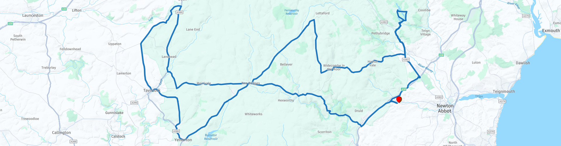
 This is a superb round trip of Dartmoor that will have you saying 'WoW' around every corner. There are ancient historic sites, vast open moorland landscapes, exquisitely beautiful rivers, 3 historic reservoirs and views that go on forever. This route is almost exclusively within the National Park and a speed limit of 40mph gives you chance to soak up your surroundings as well as protecting the free roaming livestock. There are some small roads that might have a little mud on them especially around the reservoirs, but the views are definitely worth it. The landscapes and attractions are excellant and the undulating roads very good earning this route the top score of 5***** stars.
 Share this route


Animation

Verdict


Duration
6h 33m

Mode of travel
Car or motorcycle

Distance
143.27 km

Countries

 RouteXpert Review
 Dartmoor National Park is one of the last great wildernesses in the UK with an inspirational landscape of heather clad moors and rugged tors. A tor is a large, free-standing rock outcrop that rises abruptly from the surrounding smooth and gentle slopes of a rounded hill summit or ridge crest.
Dartmoor was designated as a National Park in 1951, a vast tract of largely untamed countryside of huge richness and diversity stretching across 368 square miles. It's a landscape quite unlike any other, populated by lofty granite tors, mysterious hut circles and standing stones, ancient woodlands, sturdy clapper bridges, rushing streams, Dartmoor ponies, bustling stannary towns and secluded villages. A stannary was an administrative division established under stannary law in the English counties of Cornwall and Devon to manage the collection of tin coinage, which was the duty payable on the metal tin smelted from the ore cassiterite mined in the region.
As well as amazing scenery, Dartmoor has many different layers to discover - curious geology and fascinating archaeology, centuries of history, the mining legacy, local legend and folklore, and its unique wildlife and flora, so let’s go and explore.
Entering the national park at Ashburton, just 5 minutes from the hotel you will cross over the River Dart twice via two medieval bridges built from local granite in the year 1413. The fact that they and many nearby bridges that are still standing today stands testament to the materials used and the men that built them. Both bridges, Holne Bridge and Newbridge are set in the wooded Dart Valley under the canopy of beech and oak trees, a sharp contrast to what comes next.
The gentle climb from the river valley takes you up to 350m to offer you your first glimpse of the sheer vastness of Dartmoor where the views seem to go on forever. The undulating road in this stunning landscape soon has you descending into another river valley and onto the well known beauty spot called Dartmeet. As the name suggests Dartmeet acts as a meeting point of the two major tributaries of the River Dart, the East Dart and the West Dart. The road bridge over the East Dart was built in 1792, while another partially collapsed medieval clapper bridge sits to the side of it.
A clapper bridge is an ancient style of bridge that uses large granite slabs, or clappers as the roadway. You will definitely want to stop here for photos of this beautiful location.
Another gentle climb up to the open moorland will take you to Dunnabridge Pound and The Judge's Chair. The pound is a prehistoric enclosure for keeping livestock and is perhaps the easiest prehistoric site to visit being just a few metres from the road.
Some academics go further and suggest that the pound could belong to a Bronze Age settlement. The Judge’s Chair is a later, 16c addition used as a shelter. Whatever the date, Dunnabridge Pound and The Judge's Chair is worthy of a visit.
Onto Two Bridges now, so called because there are two bridges! And rather fittingly, the route passes here two times because the two main roads that cross Dartmoor intersect here. On the return, you can go over the older bridge situated in the grounds of the Two Bridges Hotel.
You take a left turn now signposted for Princetown and you will see a group of austere looking buildings on your right this is Dartmoor Prison.
HMP Dartmoor is one of the UK’s most famous and notorious prisons. It’s gained such a reputation that it even has its own museum! It’s located in Princetown, in the heart of Dartmoor; and is a category C training prison for adults. The building was originally constructed in the early 1800s and was built to house prisoners of the Napoleonic Wars. Its high granite walls dominate this area of the moor. In 1920, Dartmoor began housing UK criminals. It would develop a reputation for housing some of Britain's most serious offenders that included murderers, gangsters, thieves, spies, and robbers. Dartmoor is now a Category C prison, which means it houses mainly non-violent offenders and white-collar criminals. I’m sure that the beauty of their surroundings is lost on the inmates!
The route heads north on reaching the large village of Yelverton and passes through the picturesque village of Horrabridge beside the River Walkham which is famed for salmon and trout fishing and it's medieval bridge as you make your way to Tavistock for a short coffee break.
Tavistock is a thriving, beautifully friendly market town that is worthy of any visitor. An ancient stannary town and home of the cream tea, Tavistock is the only town in Devon to hold world heritage status. The vibrancy and uniqueness of Tavistock is undeniable with a range of beautiful local independent shops which are a far cry from today's typical high street. Not to be overlooked is the famous pannier market where you’ll find my recommendation for a coffee at - Dukes Coffee House.
Passing under the old railway viaduct as you leave Tavistock you’ll soon see St Michael de Rupe, a church set high on a rocky hill. St Michael de Rupe (meaning of the Rock) was built around 1130 by Robert Giffard, a wealthy merchant, whose ship was caught in a storm off the Devon coast and who, in the midst of the tempest, cried out to his patron St Michael, that if he were saved, he would build a church upon the first land he sighted. Possibly the most spectacular church location in England and certainly one of the most photographed. It perches on the remains of a volcano 1100 ft up and is one of the highest working churches in England.
Next on the route you will see the southern entrance to Lydford Gorge, the deepest river gorge in south west England that has the 30m high Whitelady waterfall.
This steep-sided river gorge, carved into the western edge of Dartmoor, has been drawing visitors in search of the picturesque waterfall since Victorian times. Around every corner the River Lyd plunges, tumbles, swirls and gently meanders as it travels though ancient oak woodland, abundant with wildlife.
Hiking through the gorge is a challenging and rewarding adventure, be prepared for strenuous climbs and rugged ground - sturdy footwear with good grip is recommended. A charge of £10 is payable from either entrance. There are a range of walking trails to choose from. The Waterfall trail is a moderate circular walk of about an hour. The Devil's Cauldron trail is a moderate one-way circular trail taking in the deepest part of Lydford Gorge, it takes around 45 minutes and is best accessed from the northern entrance. The full Lydford Gorge trail takes around 2.5 hours to complete and is a challenging circular walk with narrow slippery paths and steep drops. On this one-way route you can see the Devil's Cauldron, Whitelady Waterfall, and Tunnel Falls.
The village of Lydford has an unforgettable setting on the western edge of Dartmoor, just upriver from the spectacular Lydford Gorge. Its importance in Saxon and medieval times has left its legacy in the street layout and in two castles: a post-Conquest castle, of which the earthworks remain, and a 13th-century tower, built on top of a 12th-century predecessor. This latter castle served as a prison for enforcing the laws that regulated both Dartmoor’s forest and also its important tin industry.
The Engine House of the old Wheal Betsy tin mine can be seen on your left as you head back onto the moor. Engine houses contained the steam engine that powered the mine. The chimney of the engine house has for many years leaned at a precarious angle a bit like the tower in Pisa. This lean can only be viewed if you park up and walk down to it.
The medieval Harford Bridge takes you back onto the high moorland and onto Two Bridges again. Don’t forget that you can take the hotel turning on your right and cross over the older of the two bridges.
The spooky Hairy Hands bridge is next. Dartmoor has lots of ghostly tales and legends and this legend is that a pair of hairy hands appear on your handlebars and try to force you off the road. There have been many incidents on this stretch of road which is notorious for fatal accidents, including in 1921 when a medical officer from Dartmoor Prison died after his motorbike went out of control. This area was avoided long before motor vehicles.
If you escape the Hairy Hands, a mile further on you’ll see the clapper bridge at Postbridge, one of the finest in the country. It is believed to date back to medieval times and would probably have replaced stepping stones to help pack-horses cross the East Dart river. The bridge has two central piers spanned by three large granite slabs, or clappers.
A couple of miles after Postbridge you turn off of the main road to join a smaller road that has spectacular tors on either side. High above you between Hookney Tor and Hameldown Tor is the best known of many prehistoric settlements on Dartmoor, Grimspound. Dating from the late Bronze Age (about 1450–700 BC). The remains of 24 stone roundhouses survive here, within a massive boundary wall about 150 metres in diameter. You can park up and visit but be warned, it’s a steep climb.
A well deserved lunch stop is next in the delightful and picturesque village of Widecombe in the Moor. A village steeped in history and famous the world over for Widecombe Fair and Uncle Tom Cobley. Information boards in the car park will reveal all. The Café on the Green serves great food and coffee and with a safe place to park your bike it makes an ideal place for lunch.
After lunch the route heads east past Haytor Rocks. Haytor Rocks is an impressive granite outcrop on the vast upland of Dartmoor. This area is dominated on its summit by massive outcrops of granite rock known locally as tors. Haytor Rock is not the highest of all the outcrops here on Dartmoor but is definitely the most well known, the most famous, the most impressive and must be the easiest one to get to out of all of them. There is a car park if you fancy walking to the top to admire the views and maybe work off the lunch that you have just eaten!
At Bovey Tracey, a market town on the eastern edge of Dartmoor, you can choose to turn right and go back to the hotel about 10 minutes from here, or follow the route to visit three beautiful reservoirs; this will take about 1 hour.
Discover a haven of history and beauty at the three reservoirs on the eastern fringe of Dartmoor National Park. Soak up the peaceful atmosphere of the surrounding farmland, forests and water.
Trenchford Reservoir is the first to visit and is also the youngest of the three closely linked reservoirs and was constructed in 1903. This 33 acre V shaped reservoir is very deep in places and is a dedicated pike fishery with fish up to 27lbs. A dam that you ride over connects it to Tottiford Reservoir on the right, the oldest reservoir on Dartmoor being constructed in 1861. Ponder the hidden secrets lying beneath the water at Tottiford, a prehistoric ceremonial complex was uncovered in the mud in 2009, when the water levels dropped. The complex consists of stone rows, burial cairns and a stone circle, measuring 27 metres in diameter. Some finely worked flint tools were also found close to the complex, including knives, piercers and notched blades. A surfaced forest road then takes you to Kennick Reservoir, the largest of the three. This 50 acre lake, constructed in 1881 is considered the jewel in the crown of fishing on Dartmoor. Kennick is a top rated premier rainbow trout fishery and is regularly stocked with rainbow trout from 2lbs to 6lbs. There is a resident head of wild brown trout up to 8lbs (all brown trout must be released if caught) with angling from bank and boat.
The route now heads back to Bovey Tracey and onto your hotel at Bickington. The Dartmoor Halfway Inn.
Enjoy.


 Links
Links  Usage
Usage Want to download this route?
You can download the route for free without MyRoute-app account. To do so, open the route and click 'save as'. Want to edit this route?
No problem, start by opening the route. Follow the tutorial and create your personal MyRoute-app account. After registration, your trial starts automatically.  Disclaimer
Use of this GPS route is at your own expense and risk. The route has been carefully composed and checked by a MyRoute-app accredited RouteXpert for use on TomTom, Garmin and MyRoute-app Navigation.
Changes may nevertheless have occurred due to changed circumstances, road diversions or seasonal closures. We therefore recommend checking each route before use.
Preferably use the route track in your navigation system. More information about the use of MyRoute-app can be found on the website under 'Community' or 'Academy'.

South West
About this region
The points of the compass are an evenly spaced set of horizontal directions (or azimuths) used in navigation and geography. A compass rose is primarily composed of four cardinal directions—north, east, south, and west—each separated by 90 degrees, and secondarily divided by four ordinal (intercardinal) directions—northeast, southeast, southwest, and northwest—each located halfway between two cardinal directions. Some disciplines such as meteorology and navigation further divide the compass with additional azimuths. Within European tradition, a fully defined compass has 32 'points' (and any finer subdivisions are described in fractions of points).Compass points are valuable in that they allow a user to refer to a specific azimuth in a colloquial fashion, without having to compute or remember degrees.
Read more on Wikipedia
View region
 Statistics
  42
42Amount of RX reviews (South West)
 24420
24420Amount of visitors (South West)
 3706
3706Amount of downloads (South West)
 Route Collections in this region
 Great 6 day tour of Wales
This collection of 6 routes all pass through at least 1 of the 3 spectacular national parks of Wales'. Each park is unique and individual and the landscapes vary from the vast, remote and wide open moorland of the Brecon Beacons to the rugged mountains and glistening lakes of Snowdonia and the spectacular coastline of the Pembrokeshire coast. Each is a delight to travel through and these routes will take you to some of the best beauty spots.
There are some great attractions to visit too, as well as having more than it's fair share of fantastic castles and historic buildings, there is the worlds fastest zip line, a balcony road used for world rally stages, mysterious caves and magical waterfalls and a museum of land speed records. All of these can be seen on the routes in this collection.
Although each route in this collection is a separate stand alone route, they will all link up seamlessly to make a 6 day tour that you will remember. The tour starts and ends in Gloucester which can be easily reached in a day from any of the Channel ports.
Enjoy Wales.
View Route Collection
Top 10 Downloaded UK routes by RouteXpert Nick Carthew
Hello and welcome to this collection of the Top 10 MyRoute app downloaded routes in the UK.
There will be a great new event to be announced soon, where all these routes can be ridden.
Download them all now and place them in a new "Top 10" folder, so that you always have them at hand.
If you are going to drive one of these routes in the meantime, track them with the MRA Mobile App or with MRA Navigation. Take some photos (moments) along the way as these will come in handy.
Create a travelstory of your Top 10 driven routes and add the recorded track to it.
There will also be some great prizes on offer, so keep an eye on the MRA-RouteXperts page and your email.
View Route Collection