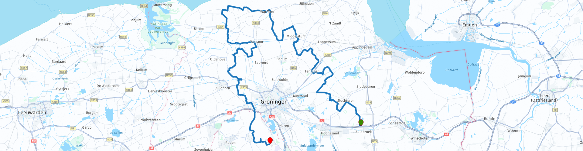
TTT 2014 04 Zuidbroek Eelde

This route was brought to you by:
RouteXpert Hans van de Ven (Mr.MRA)
Last edit: 22-12-2019
 Route Summary
 The 173 ANWB Promoter TankTasTocht (TTT) were scanned by Henry ten Dam and signed by Leon Stolk in Mapsource and later placed as a Track in a .gpx file. These are made available through the MrGPS website with the approval of the ANWB Promoter so that everyone can enjoy them. The 1st TTT is from 1992, so the route may differ slightly from the original.
I have checked all route points and, where necessary, placed them neatly on the road. Also, if necessary, I have further spaced the start point and end point of the route to avoid navigating directly to the end point and I added the POI files from the start and end point just like a possible stopping point.
Finally, I made the route the same for TomTom, Garmin and MyRoute-app Navigation users.
Thanks to Henry, Leon, MrGPS and Promoter.
 Share this route


Animation

Verdict


Duration
3h 10m

Mode of travel
Car or motorcycle

Distance
132.93 km

Countries

 RouteXpert Review
 Furthermore, you will pass in this route, among other things, the drainage channel of Duurswold, this is a canal that was dug between 1869 and 1871 for the drainage of the Duurswold region. From the commissioning until 1986, it was managed by the Duurswold water board and the Eems canal, which connects the city of Groningen with Delfzijl. The canal was constructed between 1866 and 1876.
A stop is included in Pieterburen, at Restaurantschip 't Appeltje or at the Zeehondencentrum. The Pieterburen Seal Center, formerly the Pieterburen Seal Sanctuary, is a shelter for seals in the Netherlands. It was once called seal sanctuary because it mainly caught young orphaned seals.
After the stop you will pass, among other things, the Hoornse Vaart, this canal was built in the 19th century. The canal was partly constructed in the course of the disappeared river Swalve. The sand released during the digging of this canal and the Hunsingo canal in 1873 would have owed its existence to the southeast of Leens. Workers' homes were built on this sand. The canal runs from the Mensingeweersterloopdiep westwards past Wehe-den Hoorn and then along the north side of the area of the former borg Starkenborgh and the Aduarderdiep, this is a 12 kilometer long canal. For centuries it has been of great importance for the drainage of the surrounding area.
At the Allersmaborg, possibly taking some pictures, this is a deposit in the hamlet of Allersma between Ezinge and Aduarderzijl. The Allersmaborg dates from the Middle Ages and lies within a spacious canal with drawbridge and is surrounded by an English garden and wood girdles. The estate is surrounded by an estate of approximately 2 hectares, including an orchard with old Groningen fruit varieties, including Groninger Kroon and Gypsy.
After the Allersmaborg you cross the Van Starkenborgh Canal, this is a channel that connects the Princess Margriet Canal with the Eems Canal. Finally you will pass through the Matsloot area, the Matsloot area is very suitable for water and marsh birds, for amphibians and fish, for dragonflies and Otters. The dynamics of the rising and falling water gives something extra to the swamp. This will make it different every year in the Matsloot area.
Because I have not (yet) driven this route myself, this route gets 3 stars.
Route details:
rp 26 - Lunch possibility in Pieterburen at Restaurantschip 't Appeltje
rp 27 - Possibility to visit the seal center in Pieterburen.


 Links
Links  Usage
Usage Want to download this route?
You can download the route for free without MyRoute-app account. To do so, open the route and click 'save as'. Want to edit this route?
No problem, start by opening the route. Follow the tutorial and create your personal MyRoute-app account. After registration, your trial starts automatically.  Disclaimer
Use of this GPS route is at your own expense and risk. The route has been carefully composed and checked by a MyRoute-app accredited RouteXpert for use on TomTom, Garmin and MyRoute-app Navigation.
Changes may nevertheless have occurred due to changed circumstances, road diversions or seasonal closures. We therefore recommend checking each route before use.
Preferably use the route track in your navigation system. More information about the use of MyRoute-app can be found on the website under 'Community' or 'Academy'.