TTT 2000 01 Rondje Altena

This route was brought to you by:
RouteXpert Hans van de Ven (Mr.MRA)
Last edit: 16-05-2024
 Route Summary
 The 173 ANWB Promoter TankTasTochten (TTT) were scanned by Henry ten Dam and signed by Leon Stolk in Mapsource and later placed as a Track in a .gpx file. These have been made available with the approval of ANWB Promotor via the website of MrGPS so that everyone can enjoy it. The 1st TTT is from 1992, so the route may be slightly different from the original.
I checked all route points and placed them neatly on the road. Also, if necessary, I have put the start point and end point of the route a bit further apart to avoid navigating directly to the end point and I have added the POI files from the start and end point just like a possible stopping point.
Finally, I created the route for TomTom, Garmin and MyRoute-app Navigation users.
With thanks to Henry, Leon, MrGPS and Promoter.
 Share this route


Animation

Verdict


Duration
3h 37m

Mode of travel
Car or motorcycle

Distance
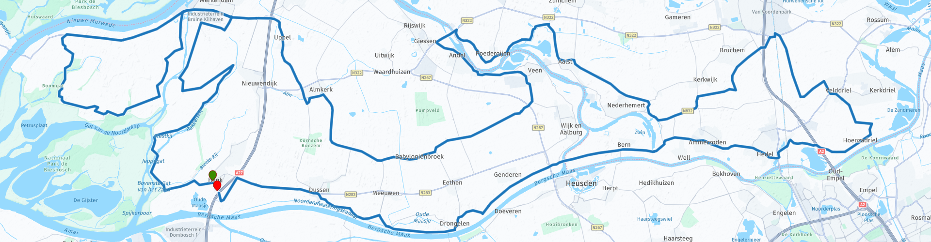
140.68 km

Countries

 RouteXpert Review
 De Biesbosch National Park is the name for a very water-rich nature and recreation area in the Netherlands with freshwater tides, creeks and willow flood forests. It consists of a number of river islands and sand and mud flats in the provinces of Noord-Brabant and Zuid-Holland that lie between the rivers Boven-Merwede and Amer, and that are intersected by the artificial river Nieuwe Merwede. On the east side, the area is bordered by the Land of Heusden and Altena. It can be subdivided into the Brabantse Biesbosch and the Hollandse Biesbosch, the latter again consisting of the Sliedrechtse Biesbosch and the Dordtse Biesbosch. (Source: Wikipedia).
After 43 km you leave Werkendam again to set course in the direction of Almkerk, Wijk and Aalburg & Veen, then you cross the dammed mesh at Giessen in the direction of Poederoijen. You are now about halfway through the TTT, so time for a snack and a drink. You can do this at "De Kraay" in Zuilichem. After lunch you continue your tour through the "Land van Heusden and Altena".
The Land of Heusden and Altena is a region in the north of the Dutch province of Noord-Brabant that is bordered by the Merwede in the north, the Afgedamde Maas and the Heusdensch Kanaal in the east, the Biesbosch in the west and the Bergsche Maas in South. The largest place in the area is Werkendam with around 12,000 inhabitants. Woudrichem is the most historically important place, a fortified city with around 4500 inhabitants. The entire region used to be part of the Groote or Hollandsche Waard. The entire area is located in one municipality: Altena with the capital Almkerk. A total of around 55,000 people (2014) live in 21 villages. Until the opening of the Merwedebrug near Gorinchem in 1961 it was essentially an island with an isolated population. In terms of landscape, it forms the continuation of the Gelderland river area, in particular of the adjacent Bommelerwaard. The clay soil differs greatly from the sandy soil that is more familiar in Brabant. Since January 1, 2019, the entire Land of Heusden and Altena have belonged to a single municipality, namely the Altena merged municipality. In 1994 the region received the status of national park, since then officially called National Park De Biesbosch, and is on the list of protected nature reserves. The Biesbosch is partly used for agriculture, is designed for various forms of recreation and also offers space for the storage of clean surface water in specially constructed reservoirs for the continuity of the drinking water supply. (Source: Wikipedia).
And then you drive along Aalst, Nederhemert, Velddriel, Hedel, Ammerzoden, Drongelen & Dussen to reach Hank again at the end point.
Because I have not (yet) driven this route myself, this route gets 3 stars.
Route details:
The route has been made the same for TomTom, Garmin and MyRoute-app Navigation users. That has been successful everywhere except between the route points: 15, 16, 17, 18, 36 and 37 (Purple), where TomTom and Garmin do not agree with each other. Not a big problem, if you drive alone you just follow the instructions of your GPS, if you drive in a group then you follow the driver. At the route points 16, 18 and 37 the two come together again and your GPS will follow the route correctly again.
rp 32 - Lunch possibility at "De Kraay" in Zuilichem.
rp 48 - Parking place for a photo moment.
17-06-2019: Route adjusted after receiving information about changes to the road network.


 Links
Links  Usage
Usage Want to download this route?
You can download the route for free without MyRoute-app account. To do so, open the route and click 'save as'. Want to edit this route?
No problem, start by opening the route. Follow the tutorial and create your personal MyRoute-app account. After registration, your trial starts automatically.  Disclaimer
Use of this GPS route is at your own expense and risk. The route has been carefully composed and checked by a MyRoute-app accredited RouteXpert for use on TomTom, Garmin and MyRoute-app Navigation.
Changes may nevertheless have occurred due to changed circumstances, road diversions or seasonal closures. We therefore recommend checking each route before use.
Preferably use the route track in your navigation system. More information about the use of MyRoute-app can be found on the website under 'Community' or 'Academy'.