19 Dijk en Duinroute

This route was brought to you by:
RouteXpert Hans van de Ven (Mr.MRA)
Last edit: 05-04-2025
 Route Summary
 This is the 19th in a series of 43 Endangered ANWB routes. These were published in the Promotors between April 2015 and September 2016.
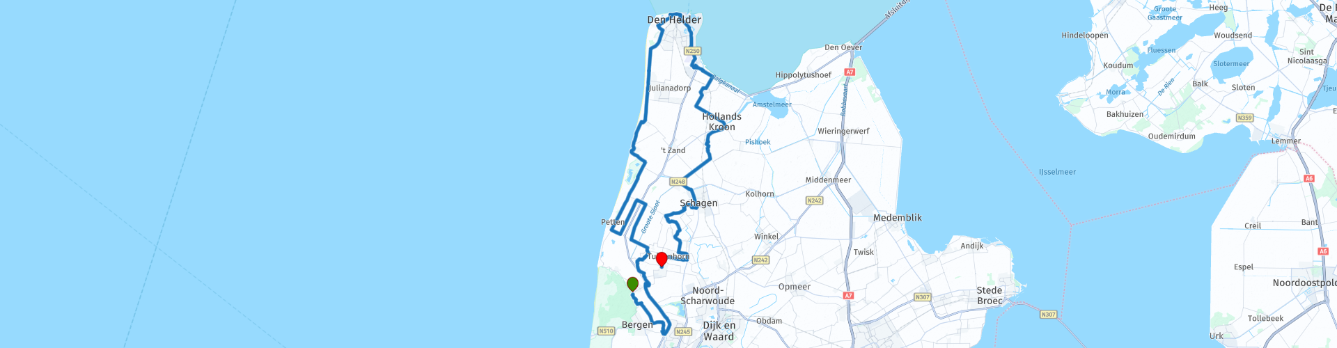
Starting point: Restaurant 't Trefpunt in Groet
End point: Globe Streetfood in Warmenhuizen
I awarded this route 3 stars because the scenery is excellent, the roads are well maintained, and the sights are impressive.
 Share this route


Animation

Verdict


Duration
3h 45m

Mode of travel
Car or motorcycle

Distance
109.64 km

Countries

 RouteXpert Review
 Your motorcycle adventure starts at Restaurant 't Trefpunt in Groet. A logical place, because you are right on the edge of the North Holland Dune Reserve. From here you quickly take a quiet dune road towards Bergen. In the early morning the dune landscape is still serene, the asphalt is dry and clean, the first bends wake you up immediately. Via Schoorl and Bergen you ride over the Kogendijk along the North Holland Canal. Here is the first Tour Info Point, and that is not without reason: this canal was of vital importance to shipping in the 19th century. You follow the water north to Warmenhuizen, where you turn inland. The route winds further via Burgerbrug and Sint Maartensbrug to the coast at Petten. A wonderfully open stretch with wide views and crisp sea air. Then it goes via Callantsoog to the Juttersmuseum, a real Tour Info Point. Here you will find a colorful collection of beach finds and stories from the fishermen's life. After that it becomes seriously maritime. You drive into Den Helder via the coastal road, where the atmosphere changes: tough, military and historical. You pass Fort Erfprins, the largest fort of the Defence Line of Den Helder. Right after that follows the Submarine Service Monument, which commemorates the Dutch submarines and their crews. A short tribute during your ride.
A little later you will be at the gate of the Vlootbasis Den Helder. You don't have to be a soldier to be impressed by the size and history of this place. Then take a break at Fort Westoever, an old defense post that now serves as an atmospheric catering establishment on the water. An ideal Tour Break Point. After Den Helder you head south via Breezand and Anna Paulowna. Driving here feels like a quiet intermezzo - fewer bends, more polder. You can relax again, the view to infinity. But towards Schagen it becomes exciting again. You zigzag along ditches and farmhouses and touch the edge of the town.
Just fill up at TotalEnergies De Banne, and you are ready for the last part. Via Tuitjenhorn and Warmenhuizen you arrive at the cozy Globe Streetfood, the Tour End Point of this ride. Order a burger, have a drink and let the route sink in.
The Dike and Dune Route is a relaxed tour that shows a lot of North Holland: dunes, dikes, forts and fishing villages. You ride on quiet roads with good asphalt and get several chances to get off for a photo or visit. The route can be easily incorporated into a day trip and is suitable for motorcyclists of all levels. Start with a coffee in Groet, end with street food in Warmenhuizen - and enjoy the wind through your visor in between.


 Links
Links  Usage
Usage Want to download this route?
You can download the route for free without MyRoute-app account. To do so, open the route and click 'save as'. Want to edit this route?
No problem, start by opening the route. Follow the tutorial and create your personal MyRoute-app account. After registration, your trial starts automatically.  Disclaimer
Use of this GPS route is at your own expense and risk. The route has been carefully composed and checked by a MyRoute-app accredited RouteXpert for use on TomTom, Garmin and MyRoute-app Navigation.
Changes may nevertheless have occurred due to changed circumstances, road diversions or seasonal closures. We therefore recommend checking each route before use.
Preferably use the route track in your navigation system. More information about the use of MyRoute-app can be found on the website under 'Community' or 'Academy'.