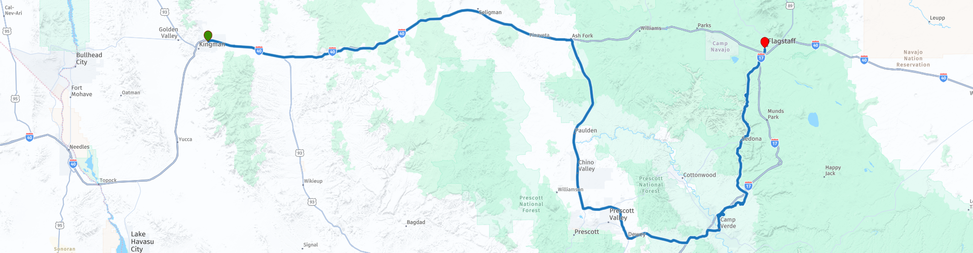
R03 Kingman Flagstaff

This route was brought to you by:
RouteXpert Hans van de Ven (Mr.MRA)
Last edit: 29-12-2019
 Route Summary
 During this journey you will travel through the following states: California, Arizona, Utah & Nevada.
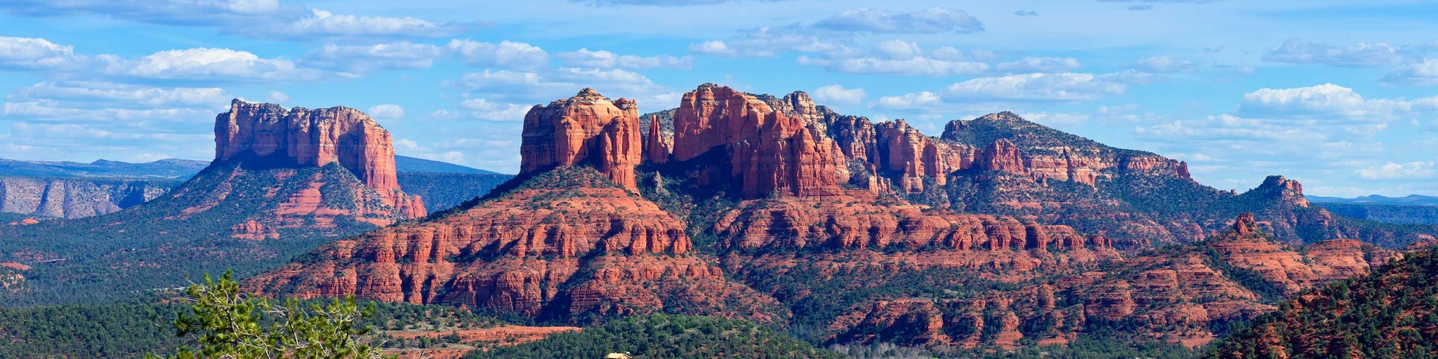
The roads are good, the area hilly and dry and the views beautiful, definitely stop in Sedona and don't forget your camera!
Starting point: Best Western A Wayfarer's Inn.
End point: Hotel Days Inn Flagstaff.
The route has been made the same for TomTom, Garmin and MyRoute-app Navigation users.
Thanks to Richard & Lisa for the information!
 Share this route


Animation

Verdict


Duration
4h 48m

Mode of travel
Car or motorcycle

Distance
388.84 km

Countries

 RouteXpert Review
 The center of Flagstaff dates from 1900. There are unique shops, restaurants and small galleries. The Visitor Center is located in the former train station. Here you can go for information about sights.
So you are going to Flagstaff today. The first part of the trip is about the Interstate 40, after which you go into the interior of Arizona to see different riches of the state of Arizona. The route takes you via Prescott and Camp Verde to the famous Montezuma Castle.
The ruins of Montezuma Castle are located just off Interstate 17 between Phoenix and Flagstaff, about 150 kilometers north of Phoenix. The Sinagua, the name the Spaniards gave to the Indians who apparently lived here without water, built the five-storey structure with its twenty rooms between 1100 and 1200. They left again at the beginning of the fifteenth century. The first pioneers initially thought that this empty "castle" was built by the Aztecs, which is why they came up with the name Montezuma's Castle.
The Visitor center is the first stop on a visit. It offers Native American objects, a time story about the discovery and protection of the ruins and information about life in the desert, including tarantella's and rattlesnakes. You then walk along a wide path under shady sycamore to the ruins. Unfortunately, it is not allowed to enter the ruin and therefore it pays to look at it from different angles. About thirty meters above the floor of the valley, the building drops a large hole in the wall of the cliff. Long ladders once reached the small doors above. It was suspected that this construction was for protection against enemies, but in daily use it was not easy. There were probably other reasons for building like this. People did not have to worry about rain or snow, and in the summer the room offered nice shade, while the sun's rays did shine in the room in winter because of its location. Around fifty people once lived here.
A little further along the path is Castle A. This ruin is not nearly as well-known but was once much larger than Montezuma's Castle. However, little is left of it except a few low walls. Castle A once had six floors and 45 rooms. Equally impressive is the Montezuma Well. It is located about 15 kilometers northeast of the Castle. This natural hole in the ground with its water at the bottom once served as an oasis. Below the edge are the remains of houses visible. There is a walking path around the edge, but you can also walk down to the water
runs away in an irrigation canal. It is replenished from the bottom up in a natural process so that it is never completely empty. The Sinagua used the water to irrigate their fields. In some places you can see remnants of their villages and irrigation canals, such as the Hohokam pithouse along the way to the source. Practical information (Take Exit 289 from Interstate 17, 150 kilometers from Phoenix, 80 kilometers from Flagstaff. The entrance fee is $ 2, free with an Eagle Pass. Open from 8 to 5 in winter, from 8 to 7 in summer).
Then we leave Interstate 17 to head north again, because you should not miss a visit to the red rock formations of Sedona. The view from the engine is beautiful, truly phenomenal. Everyone who comes to Sedona wants to see the red rocks for which the region is famous. But not everyone knows that it takes a fairly short walk in Red Rock State Park, just outside the city, to get a spectacular panoramic view of the rust-colored sand formations. Eagle's Nest Trail, for example, first takes the visitor down to Oak Creek and then to the highest point in the park, at 4100 feet, where you can look around in 360 degrees at the red rocks but also at the Mingus Mountain a bit further in the Verde Valley. It is a route of just over three kilometers that is easy to walk. Red Rock State Park has a network of eight kilometers of hiking trails that are interconnected.
Of course you can take a dip in the swimming pool in the hotel in the evening. Fortunately the shops, bars and restaurant are within walking distance of the hotel, and you can walk here if you still have the money.
In this 4-star route you will drive along beautiful good roads, where you will certainly fall from one surprise to the other in Sedona. Take enough water with you!
General information:
Flagstaff is named after the flagpole that an entrepreneurial pioneer put down in 1876. He did that next to his house, in the middle of nowhere. Today, Flagstaff is a town that mainly serves as a base for trips to the Grand Canyon and the other monuments in Northern Arizona.
It is a pleasant and unremarkable town and can be used as a base for the area. Flagstaff is within driving distance of a large number of attractive destinations. In addition to the Grand Canyon are Crater Monument, Wallnut Canyon, Sedona, Fort Verde, Montezuma's Castle and a stretch of Route 66.
The Lowell Observatoy observatory is located in Flagstaff itself. This is one of the most important observatories in America, the place where, for example, the planet Pluto was discovered. The two museums of the city are also very nice. One is dedicated to local history and has the charm of an amateur collection, the other is dedicated to the Indians and is one of the better museums in this area. In downtown you can visit The Black Bean Burrito Bar & Salsa Co. recommend. 12 E. Route 66. We also ate well in the student neighborhood, in the local brewery, the Beaver Street Brewery.


 Links
Links  Usage
Usage Want to download this route?
You can download the route for free without MyRoute-app account. To do so, open the route and click 'save as'. Want to edit this route?
No problem, start by opening the route. Follow the tutorial and create your personal MyRoute-app account. After registration, your trial starts automatically.  Disclaimer
Use of this GPS route is at your own expense and risk. The route has been carefully composed and checked by a MyRoute-app accredited RouteXpert for use on TomTom, Garmin and MyRoute-app Navigation.
Changes may nevertheless have occurred due to changed circumstances, road diversions or seasonal closures. We therefore recommend checking each route before use.
Preferably use the route track in your navigation system. More information about the use of MyRoute-app can be found on the website under 'Community' or 'Academy'.
.jpg/800px-Grand_Canyon_Horseshoe_Bend_(crop_2).jpg)
Arizona
About this region
Arizona (AIR-iz-OH-nə; Navajo: Hoozdo Hahoodzo Navajo pronunciation: [hoː˥z̥to˩ ha˩hoː˩tso˩]; O'odham: Alĭ ṣonak) is a state in the Western United States, grouped in the Southwestern and occasionally Mountain subregions. It is the 6th largest and the 14th most populous of the 50 states. Its capital and largest city is Phoenix. Arizona shares the Four Corners region with Utah to the north, Colorado to the northeast, and New Mexico to the east; its other neighboring states are Nevada and California to the west and the Mexican states of Sonora and Baja California to the south and southwest.
Arizona is the 48th state and last of the contiguous states to be admitted to the Union, achieving statehood on February 14, 1912. Historically part of the territory of Alta California in New Spain, it became part of independent Mexico in 1821. After being defeated in the Mexican–American War, Mexico ceded much of this territory to the United States in 1848. The southernmost portion of the state was acquired in 1853 through the Gadsden Purchase.
Southern Arizona is known for its desert climate, with very hot summers and mild winters. Northern Arizona features forests of pine, Douglas fir, and spruce trees; the Colorado Plateau; mountain ranges (such as the San Francisco Mountains); as well as large, deep canyons, with much more moderate summer temperatures and significant winter snowfalls. There are ski resorts in the areas of Flagstaff, Alpine, and Tucson. In addition to the internationally known Grand Canyon National Park, which is one of the world's seven natural wonders, there are several national forests, national parks, and national monuments.
Since the 1950s, Arizona's population and economy have grown dramatically because of migration into the state, and now the state is a major hub of the Sun Belt. Cities such as Phoenix and Tucson have developed large, sprawling suburban areas. Many large companies, such as PetSmart and Circle K, have headquarters in the state, and Arizona is home to major universities, including the University of Arizona and Arizona State University. Traditionally, the state is politically known for national conservative figures such as Barry Goldwater and John McCain, though it voted Democratic in the 1996 presidential race and in the 2020 presidential and senatorial elections.
Arizona is home to a diverse population. About one-quarter of the state is made up of Indian reservations that serve as the home of 27 federally recognized Native American tribes, including the Navajo Nation, the largest in the state and the United States, with more than 300,000 citizens. Since the 1980s, the proportion of Hispanics in the state's population has grown significantly owing to migration from Mexico. In terms of religion, a substantial portion of the population are followers of the Catholic Church and The Church of Jesus Christ of Latter-day Saints (Mormon).
Read more on Wikipedia
Arizona is the 48th state and last of the contiguous states to be admitted to the Union, achieving statehood on February 14, 1912. Historically part of the territory of Alta California in New Spain, it became part of independent Mexico in 1821. After being defeated in the Mexican–American War, Mexico ceded much of this territory to the United States in 1848. The southernmost portion of the state was acquired in 1853 through the Gadsden Purchase.
Southern Arizona is known for its desert climate, with very hot summers and mild winters. Northern Arizona features forests of pine, Douglas fir, and spruce trees; the Colorado Plateau; mountain ranges (such as the San Francisco Mountains); as well as large, deep canyons, with much more moderate summer temperatures and significant winter snowfalls. There are ski resorts in the areas of Flagstaff, Alpine, and Tucson. In addition to the internationally known Grand Canyon National Park, which is one of the world's seven natural wonders, there are several national forests, national parks, and national monuments.
Since the 1950s, Arizona's population and economy have grown dramatically because of migration into the state, and now the state is a major hub of the Sun Belt. Cities such as Phoenix and Tucson have developed large, sprawling suburban areas. Many large companies, such as PetSmart and Circle K, have headquarters in the state, and Arizona is home to major universities, including the University of Arizona and Arizona State University. Traditionally, the state is politically known for national conservative figures such as Barry Goldwater and John McCain, though it voted Democratic in the 1996 presidential race and in the 2020 presidential and senatorial elections.
Arizona is home to a diverse population. About one-quarter of the state is made up of Indian reservations that serve as the home of 27 federally recognized Native American tribes, including the Navajo Nation, the largest in the state and the United States, with more than 300,000 citizens. Since the 1980s, the proportion of Hispanics in the state's population has grown significantly owing to migration from Mexico. In terms of religion, a substantial portion of the population are followers of the Catholic Church and The Church of Jesus Christ of Latter-day Saints (Mormon).
View region
 Statistics
  20
20Amount of RX reviews (Arizona)
 25082
25082Amount of visitors (Arizona)
 531
531Amount of downloads (Arizona)
 Route Collections in this region
 Car or motorcycle tour through the western US
This collection contains all 15 routes driven by MRA Goldmember André ter Schegget during his three-week tour through the west of America.
The places to visit, the attractions and beautiful photo spots are nicely marked on the routes. The routes have been fully checked and made equal for the Garmin and the TomTom. Enjoy this wonderful trip and let us know how it was! Enjoy and stay safe!
Order of the tour:
Route 01: from Los Angeles and via Pacific Coast Highway to Solvang
Route 02: Solvang to Monterey / Pacific Grove
Route 03A: Monterey to San Francisco
Route 03B: if you are by car instead of the motorcycle, as motorcycles are not allowed on the 17 Mile Drive: from Monterey to the 17 Mile Drive and further to San Francisco
Route 04: from San Francisco via Nappa and Eldorado National Forrest to Topaz Lake
Route 05: from Topaz Lake via Bodie and Yosemite to Oakhurst
Route 06: from Oakhurst via Kings Canyon NP and Sequoia NP and Giant Forest to Exeter
Route 07: Exeter via Isabella Lake and Ridgecrest to Death Valley
Route 08: from Death Valley via Valley Of Fire to Mesquite
Route 09: from Mesquite via Zion NP and Dixie NF to Hatch
Route 10: Hatch via Bryce Canyon to Page
Route 11: from Page via Grand Canyon to Williams
Route 12: from Williams via Seligman and Route 66 to Kingman and via Hoover Dam to Las Vegas
Route 13: from Las Vegas via Oatman and Lake Havasu to Parker
Route 14: from Parker via Joshua Tree to Rancho Mirage
Route 15: Rancho Mirage via Palm Springs to Santa Monica
View Route Collection
Top car and motorcycle tour through the west of the USA
By car or motorcycle through the West of America is a journey that you do not just make, so also not driving 15 days and then back home. No, book a stay of several days in Los Angeles, Las Vegas, San Francisco and again Los Angeles to also visit several places of interest in these cities, so that this tour becomes an unforgettable tour that you can remember with pleasure.
Do not forget to arrange and pack the following items:
*This is only a summary and completely personal and may differ per person.
Take out travel insurance, +31 for numbers in GSM, (partially) take out gas, Health insurance coverage at destination?, Switch off electrical appliances, Lighting (time clock), Check passport validity, Antenna from radio/TV due to lightning, Residence address for those left behind, Remote control house alarm, Book Smart Parking.
Hand luggage:
Liquids in packaging of max. 100 ml, Liquids in hand luggage in transparent plastic bag.
For on the road:
Candy, Book, Earplugs, Country and road map(s), Directions, Maps in your navigation system
Money & Securities:
Bank card / giro card, Credit card (think pin code), Cash, Calculator for Internet banking, Medical insurance card, Travel insurance card.
Travel documents:
Passport, (International) Driver's License, Ticket(s), Reservation Tickets, Hotel Vouchers, Arrival/Departure Time, Check-in & Check-out Times, Valid Visa (ESTA), Travel Guide.
Clothing:
Underwear, Belt, Shirts/ T-shirts, Shorts, Long pants, Shoes, Socks, Swim trunks, Towel, Slippers.
Personal stuff:
Watch, House Keys, Wallet, Sunglasses.
Toiletries:
Deodorant, Shower gel / Soap, Comb / brush, Shaving equipment, Shampoo, Toothbrush, Toothpaste, Sanitary pads
Health & Medicine:
Own medicines, Insect repellent, Cold sore ointment, Ointment for insect bites, Sunscreen, Norit, Paracetamol, Suction cup for insect bites, First aid bag.
Miscellaneous:
Travel bag / waist bag, Leatherman (= checked luggage), Pen or pencil, Headlamp, Lighter, Tools & Electronics, Mobile phone & charger, Photo/video camera & charger, Memory card(s), World plug / adapter, Ipod & charger, Adapter cable Ipod, Headphones, iPad & charger, Navigation & charger/plug, Plug socket, Fuelpack battery.
Engine (accessories):
Helmet, Motorcycle clothing, Motorcycle boots, Chain lock / disc brake lock, Gloves, Bandana, Inner bags (plastic shopping bag), Insulation bag, Tension straps, Tie wraps, Rain suit, Rainaway.
Addresses:
Address list, Embassy telephone number, Telephone number to block (bank) card(s), Telephone number (airline tickets).
View Route Collection