D12 Steamboat Springs Estes Park

This route was brought to you by:
RouteXpert Hans van de Ven (Mr.MRA)
Last edit: 28-12-2019
 Route Summary
 The roads are good, the mountains high and the views wide and beautiful, don't forget your camera!
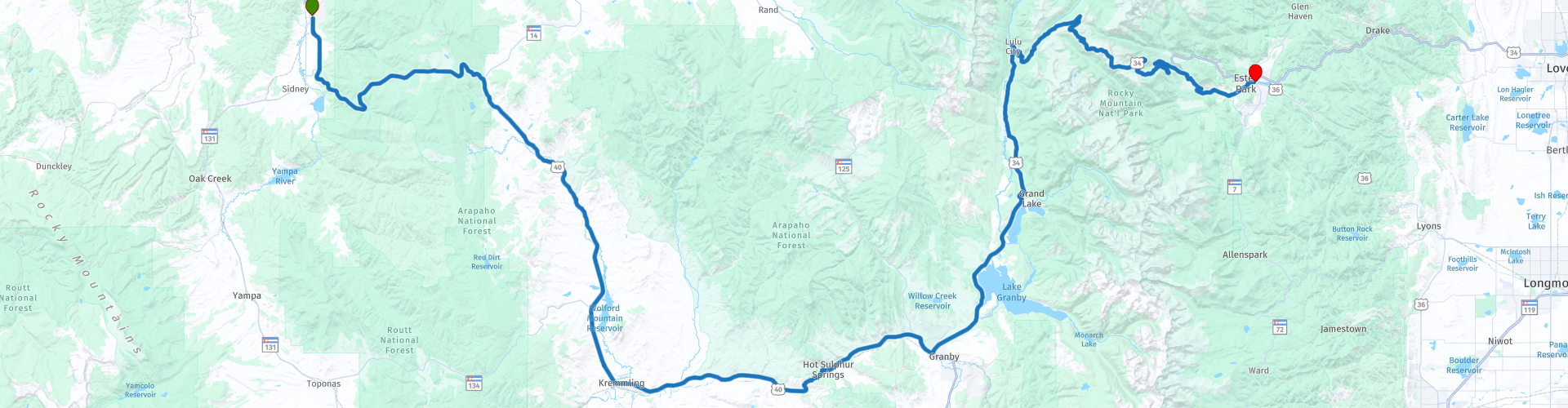
Starting point: The Steamboat Hotel.
End point: The Ridgeline Hotel Estes Park.
The route has been made the same for TomTom, Garmin and MyRoute-app Navigation users.
Thanks to Richard & Lisa for the information!
 Share this route


Animation

Verdict


Duration
3h 12m

Mode of travel
Car or motorcycle

Distance
219.96 km

Countries

 RouteXpert Review
 If you want to explore something, go to Longs Peak (4,346 meters), this is the highest peak in the area. There are few motorways in the park, but there are more than 750 kilometers of hiking trails. From Estes Park it is approximately 16 kilometers along the Bear Lake Road to Bear Lake. The road is narrow and winding and goes along beautiful lakes and ends at Bear Lake. Many walks start from here.
From Steamboat Springs we drive over the U> S. Highway 40 into the Medicine Bow-Routt National Forests, in the Medicine Bow-Routt National Forests rugged mountain tops alternate with forests, cool lakes and narrow streams. Just before Kremmling, the 1st place we visit you will pass the Wolford Mountain Reservoir, this is a reservoir in Grand County. The reservoir and its dam form part of the Wolford Mountain Recreation Area. Here you also get acquainted for the first time with the Colorado River, this is a 2334 kilometer long river in the southwest of the United States and the north of Mexico. It originates in the American state of the same name and flows through Utah, Arizona, Nevada and California before it flows into the Gulf of California on the border between Baja California and Sonora.
We continue to follow the Colorado River for the time being and this takes us to the next town we visit, Hot Sulfur Springs, this town is best known as one of the oldest, largest and most beautiful natural hot springs and resorts in the country. You can admire the Pioneer Village Museum, early tools from Grand County residents, pioneer clothing and historical Grand County artifacts displayed at the museum at the original Hot Sulfur Springs school. After the stop we drive on and pass Lake Granby, this was founded in 1950 by the establishment of Granby Dam as part of the Colorado-Big Thompson Project. Time for a short stop to take some pictures.
Then follows the 77-kilometer Trail Ridge Road. There are viewpoints and other places of interest here. The road is usually open from the second half of May to October. The route rises to more than 3,700 meters. It is possible that you will suffer from altitude sickness due to a rapid rise. You notice this by pressing headache or nausea. Along the way you will pass the Farview Curve viewpoint. From here you have a view of the Never Summer Mountains and the start of the Colorado River, which makes its way through the Kawuneechee Valley. Then you come to the Alpine Visitor Center. At the Alpine Visitor Center you are at 3,595 meters altitude. This is the highest visitor center of all national parks. You are surrounded by mountain peaks, glacier valleys and vast tundra. You can walk to the viewpoint 300 meters higher here. Finally you will pass Many Parks Curve, this viewpoint that you should definitely not miss. At 2,938 meters altitude it is one of the most spectacular viewpoints on the Trail Ridge Road.
Another 18 KM and then we are in Estes Park, where you will first have to refuel before you drive to your hotel, where you will once again process all the impressions you have made along the way.
In this 4-star route you will drive along beautiful good roads, you will make several stops along the Trail Ridge Road, where your Forest Canyon Overlook & Many Parks Curve should not be missed.
History:
The history of Estes Park begins with the powerful geological forces of tectonic elevation and glacial erosion that have formed a beautiful mountain valley and the surrounding peaks in the heart of the Rocky Mountains in Colorado for millions of years. Together they have given us the beautiful and unforgettable landscape and ecosystem that we like to share with millions of visitors from all over the world and around the world every year.
Archaeologists tell us that our human history, at least on a seasonal basis, goes back some ten thousand years to the ancestors of today's American Indians. Until the end of the 18th century, the Utes dominated the mountain area in the west and were increasingly forced to share their territory with the Arapaho, Comanche, Shoshone, and even, as suggested, with itinerant bands from Apache.
The word "Park", in the language of the mountains, means high valley. The name "Estes Park" (or "Este's Park" as it was first called) was given in the valley by William Byers, founder of the Rocky Mountain News. Rocky Mountain National Park was established in January 1915. Two years later, in April 1917, the formal establishment of the city of Estes Park and the start of the local government came to lead the affairs of a fast-growing community.


 Links
Links  Usage
Usage Want to download this route?
You can download the route for free without MyRoute-app account. To do so, open the route and click 'save as'. Want to edit this route?
No problem, start by opening the route. Follow the tutorial and create your personal MyRoute-app account. After registration, your trial starts automatically.  Disclaimer
Use of this GPS route is at your own expense and risk. The route has been carefully composed and checked by a MyRoute-app accredited RouteXpert for use on TomTom, Garmin and MyRoute-app Navigation.
Changes may nevertheless have occurred due to changed circumstances, road diversions or seasonal closures. We therefore recommend checking each route before use.
Preferably use the route track in your navigation system. More information about the use of MyRoute-app can be found on the website under 'Community' or 'Academy'.
a.jpg/800px-Maroon_Bells_(11553)a.jpg)
Colorado
About this region
Colorado is a state in the Mountain West subregion of the Western United States. It encompasses most of the Southern Rocky Mountains as well as the northeastern portion of the Colorado Plateau and the western edge of the Great Plains. Colorado is the eighth most extensive and 21st most populous U.S. state. The 2020 United States Census enumerated the population of Colorado at 5,773,714, an increase of 14.80% since the 2010 United States Census.
The region has been inhabited by Native Americans for more than 13,000 years, with the Lindenmeier Site containing artifacts dating from approximately 9200 BC to 1000 BC; the eastern edge of the Rocky Mountains was a major migration route for early peoples who spread throughout the Americas. "Colorado" is the Spanish adjective meaning "ruddy," the color of red sandstone. The Territory of Colorado was organized on February 28, 1861, and on August 1, 1876, U.S. President Ulysses S. Grant signed Proclamation 230 admitting Colorado to the Union as the 38th state. Colorado is nicknamed the "Centennial State" because it became a state one century after the signing of the United States Declaration of Independence.
Colorado is bordered by Wyoming to the north, Nebraska to the northeast, Kansas to the east, Oklahoma to the southeast, New Mexico to the south, Utah to the west, and touches Arizona to the southwest at the Four Corners. Colorado is noted for its vivid landscape of mountains, forests, high plains, mesas, canyons, plateaus, rivers, and desert lands. Colorado is one of the Mountain States and is a part of the western and southwestern United States.
Denver is the capital and most populous city in Colorado. Residents of the state are known as Coloradans, although the antiquated "Coloradoan" is occasionally used. Colorado is a comparatively wealthy state, ranking eighth in household income in 2016, and 11th in per capita income in 2010. It also ranks highly in the nation's standard of living index. Major parts of the economy include government and defense, mining, agriculture, tourism, and increasingly other kinds of manufacturing. With increasing temperatures and decreasing water availability, Colorado's agriculture, forestry and tourism economies are expected to be heavily affected by climate change.
Read more on Wikipedia
The region has been inhabited by Native Americans for more than 13,000 years, with the Lindenmeier Site containing artifacts dating from approximately 9200 BC to 1000 BC; the eastern edge of the Rocky Mountains was a major migration route for early peoples who spread throughout the Americas. "Colorado" is the Spanish adjective meaning "ruddy," the color of red sandstone. The Territory of Colorado was organized on February 28, 1861, and on August 1, 1876, U.S. President Ulysses S. Grant signed Proclamation 230 admitting Colorado to the Union as the 38th state. Colorado is nicknamed the "Centennial State" because it became a state one century after the signing of the United States Declaration of Independence.
Colorado is bordered by Wyoming to the north, Nebraska to the northeast, Kansas to the east, Oklahoma to the southeast, New Mexico to the south, Utah to the west, and touches Arizona to the southwest at the Four Corners. Colorado is noted for its vivid landscape of mountains, forests, high plains, mesas, canyons, plateaus, rivers, and desert lands. Colorado is one of the Mountain States and is a part of the western and southwestern United States.
Denver is the capital and most populous city in Colorado. Residents of the state are known as Coloradans, although the antiquated "Coloradoan" is occasionally used. Colorado is a comparatively wealthy state, ranking eighth in household income in 2016, and 11th in per capita income in 2010. It also ranks highly in the nation's standard of living index. Major parts of the economy include government and defense, mining, agriculture, tourism, and increasingly other kinds of manufacturing. With increasing temperatures and decreasing water availability, Colorado's agriculture, forestry and tourism economies are expected to be heavily affected by climate change.
View region
 Statistics
  20
20Amount of RX reviews (Colorado)
 14817
14817Amount of visitors (Colorado)
 329
329Amount of downloads (Colorado)
 Route Collections in this region
 Coast to Coast Across the USA
14 Days across the USA
Start the trip at Daytona Pier on the Atlantic Coast.
Through 14 days you will visit New Orleans, Memphis, Tulsa, Colorado Springs, Las Vegas and Los Angeles. See the sights of Monument and Death Valley, the Hoover Dam. Ride across 12 US States for 4267 miles of adventure before ending the trip on Santa Monica Pier, Los Angeles on the Pacific Coast
View Route Collection
The 10 most downloaded routes in the USA from RouteXpert Hans van de Ven
Hello and welcome to this collection of the Top 10 MyRoute app downloaded routes in USA.
There will be a great new event to be announced soon, where all these routes can be driven.
Download them all now and place them in a new "Top 10" folder, so that you always have them at hand.
If you are going to drive one of these routes in the meantime, track them with the MRA Mobile App or with MRA Navigation. Take some photos (moments) along the way as these will come in handy.
Create a travelogue of your Top 10 driven routes and add the recorded track to it.
There will also be some great prizes on offer, so keep an eye on the MRA-RouteXperts page and your mail.
The 10 routes are:
1. D13 Estes Park Denver
2. D03 Chadron Custer
3. D01 Pigeon Forge round trip through the Smokey Mountains
4. D08 Kalispell Sandpoint
5. D10 Colville Wenatchee
6. D09 Sandpoint Colville
7. D04 Custer Wall
8. D11 Wenatchee Seattle
9. D08 Cody Yellowstone NP
10.R13 San Francisco Monterey
View Route Collection