Day 117 The Ultimate USA road trip Neskowin Bandon

This route was brought to you by:
RouteXpert René Plücken (MRA Master)
Last edit: 26-02-2024
 Route Summary
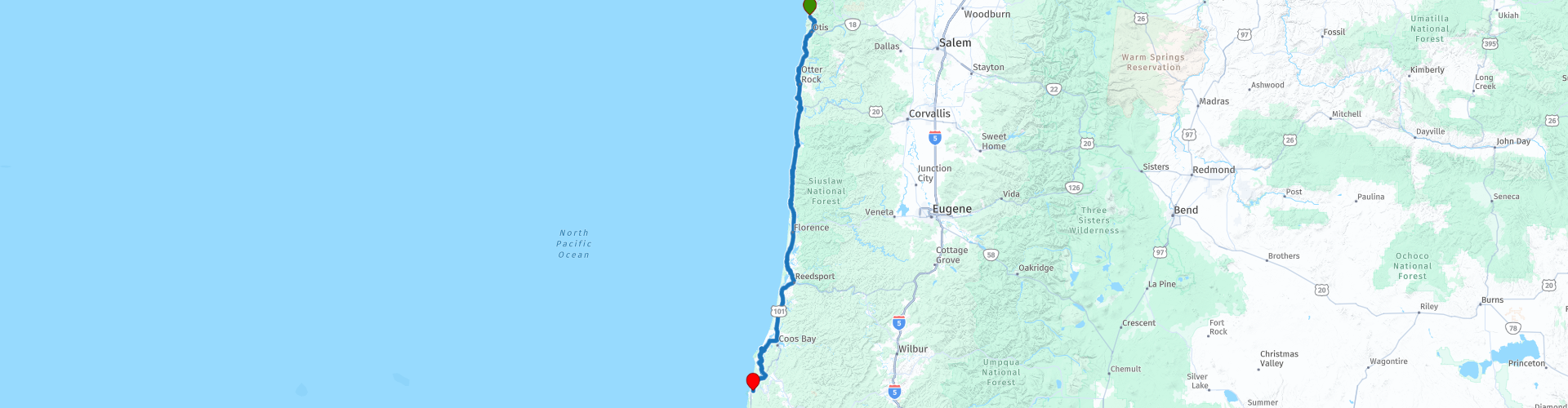
 I have further supplemented the Road Trip with even more special points that you can visit in the USA. Today we drive from Neskowin along the Pacific Coast to Bandon. It is a ride of almost 270 kilometers.
We drive on the beautiful US-101, Oregon Pacific Highway, this is part of the Pacific Coast Scenic Byway. This is the major north-south US highway that starts in Washington and runs along the western coastline of Oregon to the California border. Along the way you will enjoy beautiful views and there are several sights to visit. I rate this route 5 stars.
 Share this route


Animation

Verdict


Duration
10h 26m

Mode of travel
Car or motorcycle

Distance
274.15 km

Countries

 RouteXpert Review
 Pacific Coast Scenic Byway, US Route 101 or US Highway 101 is a north-south US Highway that runs along the west coast of the United States through the states of California, Oregon and Washington. The section in Oregon is called “Oregon Coast Highway No. 9”, has a total length of 363.11 mi (584.37 km), starts in Astoria (see day 114) and runs to the Oregon-California state line at the town of Brookings. Today we drive 270 kilometers of this route, but will also occasionally deviate from the route due to planned stops. You can find more information about this beautiful highway at the links in this review and it is definitely recommended to drive this route in a few days.
The southern part of the Byway changes a bit, as it is dominated by rugged cliffs, farms and sandy beaches. This segment features some of the most photographed areas in Oregon. There are a number of beautiful waypoints with a POI included in the route that are a must stop, such as;
• Siletz Bay; with its sea stacks and estuaries along the dense green forests. There is a small parking lot to the side with a large viewing platform that gives visitors a perfect view of the bay and the Sea stacks.
• The Boiler Bay; a wonderful and rugged bay with basalt beaches. It's a great place to watch some wild surfing action. This panoramic viewpoint offers a good opportunity to see gray whales all year round. Bring binoculars, this is one of the best places in Oregon to see seabirds, including shearwaters, skuas, albatrosses, grebes, pelicans, divers, oystercatchers and murrelets. In 1910 an explosion sank the J. Marhoffer, and at low tide you can see the ship's boiler.
• Pirate Cove; From a 40-foot cliff on the headland of Depoe Bay you can look into Pirate Cove, an inlet protected on either side by lava. At high tide, foam often collects in the middle of the bay. Seals retreat to the sandstone banks. Pirate Cove is one of two research reserves in Oregon.
• Whale Watching Center Depoe Bay; a perfect place to see whales. The center is equipped with binoculars for visitors and displays with facts about whales and information about what swimming patterns you might see. During the busiest weeks, thousands of gray whales migrate past on their way to and from the waters of Alaska and Mexico. You may spot humpback whales, orcas, dolphins, porpoises and even blue whales.
• Rocky Creek State Scenic Viewpoint; it is a spectacular oceanfront park on a wooded bluff overlooking the ocean. Rocks off the coast provide spectacular wave action during storms and are breeding areas for birds, sea lions and harbor seals. The lookout is an official Whale Spoken Here site for gray whale watching.
• Rodea Viewpoint; this part of Oregon's central coast is another notable stretch of rocky coastline where things blow up more often than not. It's an informal lookout point where a small gravel road takes you to a spot where you have more opportunities to watch the huge waves hitting these basalt ridges. They can tower far above you, often twenty feet or more, and then crash onto these rocks with an intense, even terrifying sound.
• Rocky Creek Bridge No. 01089, also known as Ben Jones Bridge, is a concrete highway bridge over Rocky Creek along the Pacific Coast in the U.S. state of Oregon. The bridge crosses a gorge near the mouth of the creek, about 2 miles (3 km) south of Depoe Bay in Lincoln County. Built in 1927, the bridge originally carried US Route 101 (the Oregon Coast Highway) over the creek. After a section of the highway was moved to make it straighter, the abandoned stretch of the old highway became Otter Crest Loop Road, a local road west of the new highway. The arch bridge, designed by Conde McCullough, is 110 meters long. McCullough, the state bridge engineer from 1919 to 1936, designed many bridges along the Oregon Coast Highway, which stretched north to south from Washington to California. Jones was an attorney who helped create Lincoln County in 1893, served as mayor of the Oregon cities of Toledo and Newport, and introduced state-level legislation that led to the construction of the Coastal Highway.
• Otter Crest State Park; enjoy the view from 150 meters above the ocean of the breathtaking crescent-shaped white sand beach stretching south. Formerly called Cape Foul Weather, it is breathtaking and inspiring with its picturesque panoramic views. This popular whale watching spot also offers a good view of the Devil's Punchbowl. The Cape Foul Weather Gift Shop is open Wednesday to Sunday from 10am to 4pm.
• Devils Punch Bowl State Natural Area; this is a park centered on a large bowl naturally carved into a rock headland and partially open to the Pacific Ocean. Waves enter the bowl and often swirl, swirl and foam violently. A large rocky outcrop called Gull Rock is visible offshore, about a half mile west-northwest of Devils Punch Bowl. There are at least seventeen large rocks, part of Oregon Islands National Wildlife Refuge, that provide interesting waves and attract and provide a home for wildlife. It is believed that the bowl was formed when two ocean-carved caves collapsed. Whales migrate seasonally past the park and this spot offers panoramic ocean views and good whale watching opportunities.
• Yaquina Lighthouse; also known early in its existence as the Cape Foul Weather Lighthouse (although Cape Foul Weather is four miles to the north). This lighthouse on the Oregon coast in the United States was built in 1873. The tower is 90 feet tall and is the tallest lighthouse in Oregon.
• Mark O. Hatfield Marine Science Center; was built in 1965 and is the center of Oregon State University's coastal research. The center is dedicated to helping solve problems that affect marine life around the world. It recently underwent a $5 million renovation and remodel (it was closed for more than a year and reopened in 1997.) The newly renovated center features a public wing that focuses on the research and findings of the Center's 300-plus marine scientists Centre. Their work is presented via interactive multimedia displays based on the theme 'In search of patterns in a complex world'. Through these displays, visitors can explore the geology of the ocean floor, learn about coastal hazards (such as earthquakes and tsunamis), and learn about advances made in whale tracking and research. The center's exhibits include a 'touch' tank with intertidal animals and a live octopus.
• The Oregon Coast Aquarium is one of the top 10 aquariums in the country and has offered an outstanding collection of marine treasures since it opened in 1992. The indoor exhibits showcase marine life found in wetlands, sandy and rocky coasts, and the deep waters of the Pacific Ocean. Outdoor exhibits are home to sea otters, seals, sea lions and a giant octopus. The Aquarium also has one of the largest seabird aviaries in North America. Dedicated to marine education and conservation, the Oregon Coast Aquarium was home to Keiko the whale, star of the movie "Free Willy," from 1996 to 1998.
• Seal Rock State Recreation Area; features large rock formations off the coast that provide a habitat for seals, sea lions, seabirds and other marine life. The beach includes interesting tide pools, as well as beautiful ocean views and a sandy beach. The short path to the beach is steep at times, but halfway there is a lookout point overlooking the beach and tide pools.
• Heceta Head Lighthouse State Scenic Viewpoint; the Heceta Head Lighthouse was built in 1894. The 17-meter-tall lighthouse emits a beam visible for a distance of 21 nautical miles (39 kilometers; 24 mi), making it the strongest light on the Oregon coast. Here you have a beautiful view of the coast and the Pacific Ocean.
• Sea Lion Caves; a private nature reserve and bird sanctuary (since 1932), centrally located on the beautiful and rugged Oregon coast. It is the largest sea cave in the Americas and home to the Steller sea lion year-round. Prepare for a wild encounter as you explore one of nature's most beautiful natural sanctuaries. Step into a world created more than 25 million years ago and feel the tranquility of the ocean waves and see the sea lions in their natural habitat.
The end point of this wonderful day is the town of Bandon, on the south side of the mouth of the Coquille River. It was named by George Bennet, an Irish colleague, who settled nearby in 1873 and named the town after Bandon in Ireland, his birthplace. There is a nice historic district with many good restaurants where you can enjoy delicious food. You can spend the night at the Lighthouse Cove Inn.


 Links
Links  Usage
Usage Want to download this route?
You can download the route for free without MyRoute-app account. To do so, open the route and click 'save as'. Want to edit this route?
No problem, start by opening the route. Follow the tutorial and create your personal MyRoute-app account. After registration, your trial starts automatically.  Disclaimer
Use of this GPS route is at your own expense and risk. The route has been carefully composed and checked by a MyRoute-app accredited RouteXpert for use on TomTom, Garmin and MyRoute-app Navigation.
Changes may nevertheless have occurred due to changed circumstances, road diversions or seasonal closures. We therefore recommend checking each route before use.
Preferably use the route track in your navigation system. More information about the use of MyRoute-app can be found on the website under 'Community' or 'Academy'.
_at_the_end_of_Nevada_State_Route_292_(Denio_Road)_at_the_Oregon_border_in_Denio,_Nevada.JPG/800px-thumbnail.jpg)
Oregon
About this region
Oregon is a state in the Pacific Northwest region of the Western United States. The Columbia River delineates much of Oregon's northern boundary with Washington, while the Snake River delineates much of its eastern boundary with Idaho. The 42° north parallel delineates the southern boundary with California and Nevada.
Oregon has been home to many indigenous nations for thousands of years. The first European traders, explorers, and settlers began exploring what is now Oregon's Pacific coast in the early-mid 16th century. As early as 1565, the Spanish began sending vessels northeast from the Philippines, riding the Kuroshio Current in a sweeping circular route across the northern part of the Pacific. In 1592, Juan de Fuca undertook detailed mapping and studies of ocean currents in the Pacific Northwest, including the Oregon coast as well as the strait now bearing his name. Spanish ships – 250 in as many years – would typically not land before reaching Cape Mendocino in California, but some landed or wrecked in what is now Oregon. Nehalem tales recount strangers and the discovery of items like chunks of beeswax and a lidded silver vase, likely connected to the 1707 wreck of the San Francisco Xavier.In 1843, an autonomous government was formed in the Oregon Country, and the Oregon Territory was created in 1848. Oregon became the 33rd state of the U.S. on February 14, 1859. Today, with 4 million people over 98,000 square miles (250,000 km2), Oregon is the ninth largest and 27th most populous U.S. state. The capital, Salem, is the second-most populous city in Oregon, with 169,798 residents. Portland, with 647,805, ranks as the 26th among U.S. cities. The Portland metropolitan area, which also includes the city of Vancouver, Washington, to the north, ranks the 25th largest metro area in the nation, with a population of 2,453,168.
Oregon is one of the most geographically diverse states in the U.S., marked by volcanoes, abundant bodies of water, dense evergreen and mixed forests, as well as high deserts and semi-arid shrublands. At 11,249 feet (3,429 m), Mount Hood, a stratovolcano, is the state's highest point. Oregon's only national park, Crater Lake National Park, comprises the caldera surrounding Crater Lake, the deepest lake in the United States. The state is also home to the single largest organism in the world, Armillaria ostoyae, a fungus that runs beneath 2,200 acres (8.9 km2) of the Malheur National Forest.Because of its diverse landscapes and waterways, Oregon's economy is largely powered by various forms of agriculture, fishing, and hydroelectric power. Oregon is also the top lumber producer of the contiguous United States, with the lumber industry dominating the state's economy during the 20th century. Technology is another one of Oregon's major economic forces, beginning in the 1970s with the establishment of the Silicon Forest and the expansion of Tektronix and Intel. Sportswear company Nike, Inc., headquartered in Beaverton, is the state's largest public corporation with an annual revenue of $30.6 billion.
Read more on Wikipedia
Oregon has been home to many indigenous nations for thousands of years. The first European traders, explorers, and settlers began exploring what is now Oregon's Pacific coast in the early-mid 16th century. As early as 1565, the Spanish began sending vessels northeast from the Philippines, riding the Kuroshio Current in a sweeping circular route across the northern part of the Pacific. In 1592, Juan de Fuca undertook detailed mapping and studies of ocean currents in the Pacific Northwest, including the Oregon coast as well as the strait now bearing his name. Spanish ships – 250 in as many years – would typically not land before reaching Cape Mendocino in California, but some landed or wrecked in what is now Oregon. Nehalem tales recount strangers and the discovery of items like chunks of beeswax and a lidded silver vase, likely connected to the 1707 wreck of the San Francisco Xavier.In 1843, an autonomous government was formed in the Oregon Country, and the Oregon Territory was created in 1848. Oregon became the 33rd state of the U.S. on February 14, 1859. Today, with 4 million people over 98,000 square miles (250,000 km2), Oregon is the ninth largest and 27th most populous U.S. state. The capital, Salem, is the second-most populous city in Oregon, with 169,798 residents. Portland, with 647,805, ranks as the 26th among U.S. cities. The Portland metropolitan area, which also includes the city of Vancouver, Washington, to the north, ranks the 25th largest metro area in the nation, with a population of 2,453,168.
Oregon is one of the most geographically diverse states in the U.S., marked by volcanoes, abundant bodies of water, dense evergreen and mixed forests, as well as high deserts and semi-arid shrublands. At 11,249 feet (3,429 m), Mount Hood, a stratovolcano, is the state's highest point. Oregon's only national park, Crater Lake National Park, comprises the caldera surrounding Crater Lake, the deepest lake in the United States. The state is also home to the single largest organism in the world, Armillaria ostoyae, a fungus that runs beneath 2,200 acres (8.9 km2) of the Malheur National Forest.Because of its diverse landscapes and waterways, Oregon's economy is largely powered by various forms of agriculture, fishing, and hydroelectric power. Oregon is also the top lumber producer of the contiguous United States, with the lumber industry dominating the state's economy during the 20th century. Technology is another one of Oregon's major economic forces, beginning in the 1970s with the establishment of the Silicon Forest and the expansion of Tektronix and Intel. Sportswear company Nike, Inc., headquartered in Beaverton, is the state's largest public corporation with an annual revenue of $30.6 billion.
View region
 Statistics
  8
8Amount of RX reviews (Oregon)
 347
347Amount of visitors (Oregon)
 58
58Amount of downloads (Oregon)
 Route Collections in this region
 Oregon Coast and Mountains
This collection of three routes takes you from Portland in the north to Roseburg in the south of Oregon. It avoids the direct and fast Interstate in favour of interesting and challenging backroads. The route passes through majestic forests, traverses mountain passes, and skirts serene Pacific coast scenery.
To experience and savour all that this collection offers, the rider will need four or five days of time. A week could easily be spent enjoying this beautiful part of the country.
To experience and savour all that this collection offers, the rider will need four or five days of time. A week could easily be spent enjoying this beautiful part of the country.
View Route Collection
Ultimate USA road trip part 12
Michel van Hagen challenged me to follow the Roadtrip of Dr. Randy Olsen as a basis to create the Ultimate USA Road Trip for the MyRoute app RouteXpert Library. I took up that challenge and started in February 2022.
The scientist Dr. Randy Olsen, who became known for using his knowledge of algorithms to find 'Waldo' in the well-known American 'Where's Waldo' book series, has been challenged by Tracy Staedter, from Discovery News, to use the same algorithm to create the perfect Road Trip by creating the US, which will visit almost every state in the US. Alaska and Hawaii are not included in this Road Trip due to their geographical location.
The following three requirements formed the basis of the route: In all 48 countries there must be at least one stop at famous points, monuments, historical sites, national parks, etc. I have added additional interesting points, beautiful tours and routes.
After more than 26 months, the job is finished and, with a lot of support from Nick Carthew, I have created 129 routes that run through the 48 states of the USA and part of Canada. This is the twelfth collection that takes you from Spokane through Washington, Oregon to San Francisco, California in ten days.
View Route Collection