R07 Torrey St George

This route was brought to you by:
RouteXpert Hans van de Ven (Mr.MRA)
Last edit: 11-01-2020
 Route Summary
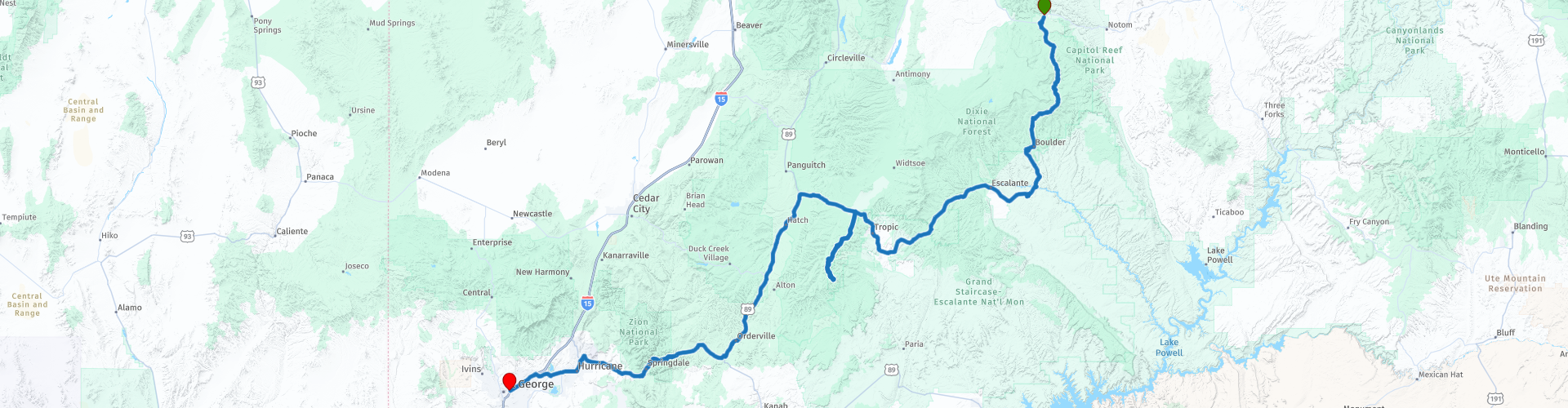
 This route is similar to the previous route, you go all the way through two well-known parks, Zion National Park and Bryce National Park, so that again guarantees the necessary stops to take photos.
During this journey you will travel through the following states: California, Arizona, Utah & Nevada.
The roads are good, the views amazing. Another day to leave early, so much to see. Don't forget your camera and your water!
Starting point: Capitol Reef Resort.
End point: Ramada Inn.
The route has been made the same for TomTom, Garmin and MyRoute-app Navigation users.
Thanks to Richard & Lisa for the information!
 Share this route


Animation

Verdict


Duration
6h 38m

Mode of travel
Car or motorcycle

Distance
442.33 km

Countries

 RouteXpert Review
 In this 4-star route you mainly drive on good roads, a long drive, but a stop in Bryce National Park and Zion National Park you should definitely do, so many endless views. Also bring enough water again!
General information:
Bryce canyon
Bryce Canyon became a National Park in 1928 and covers approximately 145 km2. It is named after the Mormon family Bryce, who lived there between 1875 and 1880. Ebenezer Bryce worked on the accessibility of the area, among other things by constructing a road. Local people called the strange area near Bryce's house "Bryce's Canyon", a name that exists until today. The area that is now a National Park in Utah was formed between 144 and 63 million years ago. The rocks were formed by the constantly attacking and receding seawater (!) That then still reached this area. The red rocks, called "hoodoos", were formed between 66 and 40 million years ago when the highest parts of the area eroded and various sediments were deposited on the bottom of rivers and lakes. Bryce Canyon is more a large series of strange, naturally formed amphitheaters consisting of rocks than a ravine. Thousands of bizarre rock formations can be found in these amphitheaters, carved out over millions of years by the water. Columns, towers, raised points in many different colors characterize this area. The limestone formations in which they originated are the famous Pink Cliffs of the state of Utah. The beautiful and colorful shapes of this area are a feast for the eyes. The colors change constantly under the weather conditions. Visitors can reach almost the entire park by car and only have to walk to a viewpoint to admire this wonderful event. You can also make guided tours on foot or by horse in the park. Where one is guided by an experienced guide. You can also make the choice to enter the park on your own. The climate of Bryce Canyon in Utah is very varied. There may be snow from October to April (average snowfall is 2.5 meters per year); In the summer, the temperature during the day is around 30 C, but at night it can drop to around 7 degrees. Thunder storms often take place. It is advised to always wear a headgear and sunscreen in Bryce Canyon because of the sun.
Zion National Park
This beautiful park owes much of its appearance to the Virgin River. A large canyon, side gorges, rich vegetation, steep rock walls and deep canyons are the ingredients of this area. The park got its status in 1919 and it covers an area of 592 square kilometers. The most important feature, and also the main attraction, is Zion Canyon. A 24 km long and 800 meter deep colorful canyon. Zion, which has been a National Park since 1919, consists of nearly 600 km2 of rocks and canyons. The name comes from the Mormons, the first whites who discovered the park; "Zion" refers to a safe place. In Zion NP there are more than 800 plant species as well as 380 different animal species (including 271 bird species). The area that now includes Zion NP is more than 250 million years old, when huge volcanic eruptions began to form the area. There were also dinosaurs at the time, of which fossils can still be found today. The rocks in the area were formed from compressed sand about 150 million years ago; the gorges that can be found in Zion were carved out of the sandstone after the Virgin River flooded about 4 million years ago. The water has since slowly but surely worn away the rocks, creating the well-known gorges. The first indications of human habitation date from around 7,000 years ago. The Anasazi Pueblo Indians then inhabited the area from about 2,500 years ago to 1150 AD. Chr., Followed by the Paiutes, who inhabited the area when the first whites visited him around 1860. Although illnesses reduce their numbers drastically, they can still be found in the Zion NP area to this day. The vast majority of the rock formations can be seen from the road, but it is certainly not unwise to make a trip so that you can see more of the park. Taking walks assures the walker of beautiful views of some of the park's more hidden beauties. It is wise to follow the Zion Scenic Drive if you are going to see the park by car. A beautiful ride through Zion canyon is then a fact.
Lower, Middle and Upper Emerald Pools Trail
At the Zion Lodge you can cross the Virgin River via a bridge. Immediately after the bridge, the path divides, right into the Lower Emerald Pools, and left into the Middle Emerald Pools. Length Lower Emerald Pool Trail: 1.9 kilometers (round trip) Height difference Lower Emerald Pool Trail: 21 meters The walk to the Lower Emerald Pool is very easy. The path is paved and runs through a shady area with many plants and trees. After a little less than 1 kilometer there is a small waterfall; the water falls down here from the top of an overhanging rock. It ends up in the small pond of the Lower Emerald Pool, just below the path. You can walk behind the waterfall; the path here is a bit slippery because of the drifting water. If you only want to see the Lower Emerald Pool, return from here via the same path. Length Middle Emerald Pool Trail: 2.7 or 3.2 kilometers (round trip) Height difference Middle Emerald Pool Trail: 46 meters The Middle Emerald Pool is 25 meters higher than the Lower Emerald Pool. There are two different paths to this small pond. You can first go to the Lower Emerald Pool, and - after walking under the waterfall - climb up a 400 meter long rocky path. Steps have been carved into the rocks at various places. The area here is much less green than around the Lower Emerald Pool Trail. You can also skip the Lower Emerald Pool. Then at the start of the walk - immediately past the Virgin River - take the left turn. This Middle Emerald Pool Trail is 1.6 kilometers long, and much steeper than the Lower Emerald Pool Trail. You climb 46 meters up here over a mainly sandy surface. As you get closer to the water hole, the path becomes a bit more rocky. From the Middle Emerald Pool you have a very nice view over the southern half of Zion Canyon. Length of the Upper Emerald Pool Trail: 1.6 kilometers (round trip) Height difference Upper Emerald Pool Trail: 61 meters The trail starts at the Middle Emerald Pool; for the total length and the total height difference you must therefore add the data from the Middle Emerald Pool Trail. Upper Emerald Pool is the largest of the three ponds. The mountain lake is sandwiched between a rock face and a small sandy beach with many boulders and plants around it. A small veil-like waterfall can be seen during the winter and spring months; the water falls down from the top of the rock face and ends up in the Upper Emerald Pool. The Upper Emerald Pool Trail is an 800-meter long trail that is dotted with boulders. You climb 61 meters up through those boulders. You can only return via the same path.


 Links
Links  Usage
Usage Want to download this route?
You can download the route for free without MyRoute-app account. To do so, open the route and click 'save as'. Want to edit this route?
No problem, start by opening the route. Follow the tutorial and create your personal MyRoute-app account. After registration, your trial starts automatically.  Disclaimer
Use of this GPS route is at your own expense and risk. The route has been carefully composed and checked by a MyRoute-app accredited RouteXpert for use on TomTom, Garmin and MyRoute-app Navigation.
Changes may nevertheless have occurred due to changed circumstances, road diversions or seasonal closures. We therefore recommend checking each route before use.
Preferably use the route track in your navigation system. More information about the use of MyRoute-app can be found on the website under 'Community' or 'Academy'.

Utah
About this region
Utah ( YOO-tah, YOO-taw) is a state in the Mountain West subregion of the Western United States. It is bordered by Colorado to the east, Wyoming to the northeast, Idaho to the north, Arizona to the south and Nevada to the west. It also touches a corner of New Mexico in the southeast. Of the fifty U.S. states, Utah is the 13th-largest by area; with a population over three million, it is the 30th-most-populous and 11th-least-densely populated. Urban development is mostly concentrated in two areas: the Wasatch Front in the north-central part of the state, which is home to roughly two-thirds of the population and includes the capital city, Salt Lake City; and Washington County in the southwest, with more than 170,000 residents. Most of the western half of Utah lies in the Great Basin.
Utah has been inhabited for thousands of years by various indigenous groups such as the ancient Puebloans, Navajo and Ute. The Spanish were the first Europeans to arrive in the mid-16th century, though the region's difficult geography and harsh climate made it a peripheral part of New Spain and later Mexico. Even while it was Mexican territory, many of Utah's earliest settlers were American, particularly Mormons fleeing marginalization and persecution from the United States. Following the Mexican–American War in 1848, the region was annexed by the U.S., becoming part of the Utah Territory, which included what is now Colorado and Nevada. Disputes between the dominant Mormon community and the federal government delayed Utah's admission as a state; only after the outlawing of polygamy was it admitted in 1896 as the 45th.
Slightly over half of all Utahns are Mormons, the vast majority of whom are members of The Church of Jesus Christ of Latter-day Saints (LDS Church), which has its world headquarters in Salt Lake City; Utah is the only state where a majority of the population belongs to a single church. The LDS Church greatly influences Utahn culture, politics, and daily life, though since the 1990s the state has become more religiously diverse as well as secular.
Utah has a highly diversified economy, with major sectors including transportation, education, information technology and research, government services, mining, and tourism. Utah has been one of the fastest growing states since 2000, with the 2020 U.S. Census confirming the fastest population growth in the nation since 2010. St. George was the fastest-growing metropolitan area in the United States from 2000 to 2005. Utah ranks among the overall best states in metrics such as healthcare, governance, education, and infrastructure. It has the 14th-highest median average income and the least income inequality of any U.S. state. A 2012 Gallup national survey found Utah overall to be the "best state to live in the future" based on 13 forward-looking measurements including various economic, lifestyle, and health-related outlook metrics.
Read more on Wikipedia
Utah has been inhabited for thousands of years by various indigenous groups such as the ancient Puebloans, Navajo and Ute. The Spanish were the first Europeans to arrive in the mid-16th century, though the region's difficult geography and harsh climate made it a peripheral part of New Spain and later Mexico. Even while it was Mexican territory, many of Utah's earliest settlers were American, particularly Mormons fleeing marginalization and persecution from the United States. Following the Mexican–American War in 1848, the region was annexed by the U.S., becoming part of the Utah Territory, which included what is now Colorado and Nevada. Disputes between the dominant Mormon community and the federal government delayed Utah's admission as a state; only after the outlawing of polygamy was it admitted in 1896 as the 45th.
Slightly over half of all Utahns are Mormons, the vast majority of whom are members of The Church of Jesus Christ of Latter-day Saints (LDS Church), which has its world headquarters in Salt Lake City; Utah is the only state where a majority of the population belongs to a single church. The LDS Church greatly influences Utahn culture, politics, and daily life, though since the 1990s the state has become more religiously diverse as well as secular.
Utah has a highly diversified economy, with major sectors including transportation, education, information technology and research, government services, mining, and tourism. Utah has been one of the fastest growing states since 2000, with the 2020 U.S. Census confirming the fastest population growth in the nation since 2010. St. George was the fastest-growing metropolitan area in the United States from 2000 to 2005. Utah ranks among the overall best states in metrics such as healthcare, governance, education, and infrastructure. It has the 14th-highest median average income and the least income inequality of any U.S. state. A 2012 Gallup national survey found Utah overall to be the "best state to live in the future" based on 13 forward-looking measurements including various economic, lifestyle, and health-related outlook metrics.
View region
 Statistics
  19
19Amount of RX reviews (Utah)
 14063
14063Amount of visitors (Utah)
 410
410Amount of downloads (Utah)
 Route Collections in this region
 Car or motorcycle tour through the western US
This collection contains all 15 routes driven by MRA Goldmember André ter Schegget during his three-week tour through the west of America.
The places to visit, the attractions and beautiful photo spots are nicely marked on the routes. The routes have been fully checked and made equal for the Garmin and the TomTom. Enjoy this wonderful trip and let us know how it was! Enjoy and stay safe!
Order of the tour:
Route 01: from Los Angeles and via Pacific Coast Highway to Solvang
Route 02: Solvang to Monterey / Pacific Grove
Route 03A: Monterey to San Francisco
Route 03B: if you are by car instead of the motorcycle, as motorcycles are not allowed on the 17 Mile Drive: from Monterey to the 17 Mile Drive and further to San Francisco
Route 04: from San Francisco via Nappa and Eldorado National Forrest to Topaz Lake
Route 05: from Topaz Lake via Bodie and Yosemite to Oakhurst
Route 06: from Oakhurst via Kings Canyon NP and Sequoia NP and Giant Forest to Exeter
Route 07: Exeter via Isabella Lake and Ridgecrest to Death Valley
Route 08: from Death Valley via Valley Of Fire to Mesquite
Route 09: from Mesquite via Zion NP and Dixie NF to Hatch
Route 10: Hatch via Bryce Canyon to Page
Route 11: from Page via Grand Canyon to Williams
Route 12: from Williams via Seligman and Route 66 to Kingman and via Hoover Dam to Las Vegas
Route 13: from Las Vegas via Oatman and Lake Havasu to Parker
Route 14: from Parker via Joshua Tree to Rancho Mirage
Route 15: Rancho Mirage via Palm Springs to Santa Monica
View Route Collection
Top car and motorcycle tour through the west of the USA
By car or motorcycle through the West of America is a journey that you do not just make, so also not driving 15 days and then back home. No, book a stay of several days in Los Angeles, Las Vegas, San Francisco and again Los Angeles to also visit several places of interest in these cities, so that this tour becomes an unforgettable tour that you can remember with pleasure.
Do not forget to arrange and pack the following items:
*This is only a summary and completely personal and may differ per person.
Take out travel insurance, +31 for numbers in GSM, (partially) take out gas, Health insurance coverage at destination?, Switch off electrical appliances, Lighting (time clock), Check passport validity, Antenna from radio/TV due to lightning, Residence address for those left behind, Remote control house alarm, Book Smart Parking.
Hand luggage:
Liquids in packaging of max. 100 ml, Liquids in hand luggage in transparent plastic bag.
For on the road:
Candy, Book, Earplugs, Country and road map(s), Directions, Maps in your navigation system
Money & Securities:
Bank card / giro card, Credit card (think pin code), Cash, Calculator for Internet banking, Medical insurance card, Travel insurance card.
Travel documents:
Passport, (International) Driver's License, Ticket(s), Reservation Tickets, Hotel Vouchers, Arrival/Departure Time, Check-in & Check-out Times, Valid Visa (ESTA), Travel Guide.
Clothing:
Underwear, Belt, Shirts/ T-shirts, Shorts, Long pants, Shoes, Socks, Swim trunks, Towel, Slippers.
Personal stuff:
Watch, House Keys, Wallet, Sunglasses.
Toiletries:
Deodorant, Shower gel / Soap, Comb / brush, Shaving equipment, Shampoo, Toothbrush, Toothpaste, Sanitary pads
Health & Medicine:
Own medicines, Insect repellent, Cold sore ointment, Ointment for insect bites, Sunscreen, Norit, Paracetamol, Suction cup for insect bites, First aid bag.
Miscellaneous:
Travel bag / waist bag, Leatherman (= checked luggage), Pen or pencil, Headlamp, Lighter, Tools & Electronics, Mobile phone & charger, Photo/video camera & charger, Memory card(s), World plug / adapter, Ipod & charger, Adapter cable Ipod, Headphones, iPad & charger, Navigation & charger/plug, Plug socket, Fuelpack battery.
Engine (accessories):
Helmet, Motorcycle clothing, Motorcycle boots, Chain lock / disc brake lock, Gloves, Bandana, Inner bags (plastic shopping bag), Insulation bag, Tension straps, Tie wraps, Rain suit, Rainaway.
Addresses:
Address list, Embassy telephone number, Telephone number to block (bank) card(s), Telephone number (airline tickets).
View Route Collection