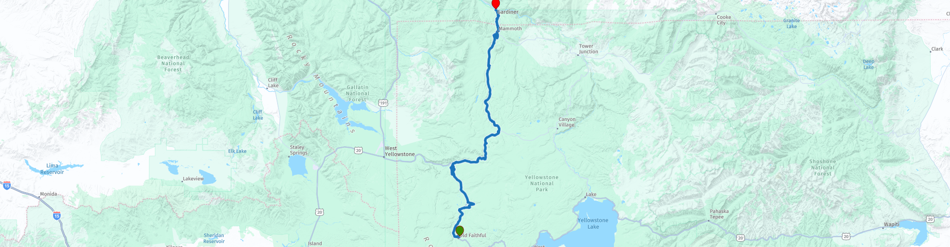
Day 102 The Ultimate USA road trip Old Faithful Gardiner

This route was brought to you by:
RouteXpert René Plücken (MRA Master)
Last edit: 28-12-2023
 Route Summary
 I have further supplemented the Road Trip with even more special points that you can visit in the USA. Today we drive Yellowstone's Grand Loop from Old Faithful Wyoming to Gardiner Montana. It is a short but spectacular ride of almost 107 kilometers.
We drive Yellowstone's Grand Loop with many beautiful attractions and beautiful panoramas. Several stops are planned along the way at geysers, lakes, rivers and waterfalls. I rate this route 5 stars.
 Share this route


Animation

Verdict


Duration
8h 11m

Mode of travel
Car or motorcycle

Distance
106.71 km

Countries

 RouteXpert Review
 Before we start the ride, we fill up with gas and do some shopping for today's ride. The Grand Loop Road in Yellowstone Park is the best way to reach the most beautiful sights in Yellowstone National Park. This stretch of Grand Loop Road runs from the Old Faithful area to Madison Junction and is the most popular and has the most geyser basins. Keep in mind that traffic and attractions can be very busy, so get an early start and make sure you plan enough time to enjoy all the beauty of this part of the park.
The most popular spots are marked with a POI and Waypoint, but there is much more to see and for the hiking enthusiast there are several hiking trails that lead you to remote geysers and springs.
The first stop is near Old Faithful at Black Sand Basin, one of a group of geothermal hot springs and geysers. The spring is too hot to use as a mineral bath, as the scorching water of 93 °C (200 °F) or hotter water has proven fatal.
The second stop just 10 minutes away at Biscuit Basin is more interesting, especially early in the morning on a sunny day. It is perfect to see the beautiful colors of the pools and there will be fewer people so you can enjoy them to the fullest.
There is a boardwalk you can follow to view the pools, springs and geysers. There are not many geysers in the Biscuit Basin, most are small bubbling springs. The main geyser visible from the designated boardwalk is the Jewel Geyser, which spouts approximately every ten minutes.
The main attractions are the Black Opal, Black Diamond and Sapphire Pools, they are breathtaking (not just because of the smell) with beautiful and vibrant colours.
It may be interesting for hikers to plan a stop at the Fairy Falls. The Fairy Falls Trail is a 2.6 mile hike to the falls. You will also pass the Grand Prismatic Spring Overlook with great spring views. It takes about 2.5 hours to walk the route. There are also two small swimming pools with beautiful colors in the parking lot.
We stop at the Grand Prismatic Spring in the Midway Geyser Basin, it is the largest hot spring in the United States and the third largest in the world. Grand Prismatic Spring was noted by geologists working in the Hayden Geological Survey of 1871 and named by them for its striking color. The colors correspond to most of the colors visible in the rainbow propagation of white light through an optical prism: red, orange, yellow, green and blue. This is a breathtakingly beautiful place to visit.
We leave the Grand Loop for a short drive on Firehole Lake Drive (when open), a short 3.1-mile one-way road with geysers and hot springs visible from the road. You can also stop and take a walk on the boardwalk.
Hikers can visit the Fountain Paint Pot area. You can walk the trail and see several hydrothermal features that are expressions of Yellowstone's still active volcano. Within this geological system, every type of thermal feature is represented. They can be grouped into two general categories: those with a lot of water (hot springs and geysers) and those with little water (mud pots and fumaroles). Despite their structural similarities, no two features are exactly the same. The walk takes about 30-45 minutes.
We visit a number of waterfalls along the route, the first is the Firehole Falls, a short walk from the car park you will see a beautiful 12 meter high waterfall in the Firehole Canyon. Another beautiful and larger waterfall to see is the one in the Gibbon River with a drop of about 26 meters.
We stop to see the Artists Paint Pots, a group of more than 50 springs, geysers, vents and, most importantly, mud pots. These exhibit varying shades of blue, gray and brown and have a range of different textures, with behavior changing throughout the year depending on the amount of underground water. All active features can be seen via an easy 0.9km trail through partly wooded country that is largely flat apart from a short climb and descent over the hill overlooking the basin.
We visit the Norris Geyser Basin and Museum; this basin contains many geysers. The geysers are of different sizes and have different eruption properties. The most famous geyser in this basin is the Steamboat Geyser, which produces the highest eruptions of all the geysers in the park and can spout to a height of over 90 meters. The Norris Geyser Basin is the hottest in the park.
You can visit the National Park Ranger Museum, housed in a log cabin across the road, staffed by very friendly and helpful Rangers. The museum tells the story of the Park Rangers and is very interesting and informative.
We stop to take some pictures of the Roaring Mountain and Sheepeater Cliffs. Roaring Mountain (2,485 m) in Yellowstone National Park is named for the numerous fumaroles on the western slope of the summit, which in the early 20th century were loud enough to be heard for miles. The Sheepeater Cliffs are a series of exposed cliffs composed of columnar basalt in Yellowstone National Park. The lava was deposited about 500,000 years ago during one of the periodic basalt floods in the Yellowstone Caldera, and later exposed by the Gardner River. The cliffs are seen as a textbook example of a basalt flow with well-defined joints and hexagonal columns. They are named after a group of Eastern Shoshone known as Tukuaduka (sheep eaters).
We drive through the Golden Gate Canyon. Glen Creek flows north through the gorge on its way to the Gardner River, descending from 8,000 feet at Kingman Pass to just under 6,000 feet in less than 3 miles, so this is an intense downhill ride. The gorge's name Golden Gate is derived from the yellow hue of the area's rocks, which shine like gold in the sun. This road was first built through the Golden Gate in 1884-1885, replacing a steep, difficult road over Snow Pass. The work included a wooden trestle where a rock wall made leveling impossible. In 1900 the viaduct was rebuilt as a concrete structure, the Chittenden Viaduct being replaced in 1930-1934. The drive through this gorge is amazing and the views are breathtaking.
The next part of the ride is a tour of Mammoth Hot Springs, which is a large complex of hot springs on a travertine hill in Yellowstone National Park, adjacent to Fort Yellowstone and the Mammoth Hot Springs Historic District. It formed over thousands of years when hot water from the spring cooled and deposited calcium carbonate (more than two tons of Mammoth flow in solution every day). Due to the enormous amount of geothermal vents, travertine, a type of lime deposit, is formed in different colors ranging from brown, orange, red and green colored.
Arriving in Mammoth we stop for a (late) lunch and you can visit the Mammoth Hot Springs Historic District, which includes Fort Yellowstone, where 35 structures still stand from the 1890s and early 20th century, when the American army managed the park .
We leave Wyoming and enter Montana, after a short drive we arrive at the final destination in Gardiner. This town on the Yellowstone River was officially founded in 1880. The area has served as the main entrance to Yellowstone National Park since its founding in 1872. Yellowstone National Park Heritage and Research Center is located in Gardiner and houses National Park Service archives, Yellowstone museum collections, and reference libraries. Enjoy your stay. There are several hotels, B&Bs and lodges on both sides of the Yellowstone River.


 Links
Links  Usage
Usage Want to download this route?
You can download the route for free without MyRoute-app account. To do so, open the route and click 'save as'. Want to edit this route?
No problem, start by opening the route. Follow the tutorial and create your personal MyRoute-app account. After registration, your trial starts automatically.  Disclaimer
Use of this GPS route is at your own expense and risk. The route has been carefully composed and checked by a MyRoute-app accredited RouteXpert for use on TomTom, Garmin and MyRoute-app Navigation.
Changes may nevertheless have occurred due to changed circumstances, road diversions or seasonal closures. We therefore recommend checking each route before use.
Preferably use the route track in your navigation system. More information about the use of MyRoute-app can be found on the website under 'Community' or 'Academy'.

Wyoming
About this region
Wyoming is a state in the Mountain West subregion of the Western United States. The 10th largest state by area, it is also the least populous and least densely populated state in the contiguous United States. It is bordered by Montana to the north and northwest, South Dakota and Nebraska to the east, Idaho to the west, Utah to the southwest, and Colorado to the south. The state population was 576,851 at the 2020 United States census, making it the least populated U.S. state. The state capital and the most populous city is Cheyenne, which had an estimated population of 63,957 in 2018.Wyoming's western half is mostly covered by the ranges and rangelands of the Rocky Mountains, while the eastern half of the state is high-elevation prairie called the High Plains. It is drier and windier than the rest of the country, being split between semi-arid and continental climates with greater temperature extremes. Almost half of the land in Wyoming is owned by the federal government, leading the state to rank 6th by area and fifth by proportion of a state's land owned by the federal government. Federal lands include two national parks—Grand Teton and Yellowstone—two national recreation areas, two national monuments, several national forests, historic sites, fish hatcheries, and wildlife refuges.
Original inhabitants of the region include the Arapaho, Crow, Lakota, and Shoshone. Southwest Wyoming was claimed by the Spanish Empire and then as Mexican territory until it was ceded to the U.S. in 1848 at the end of the Mexican–American War. The region acquired the name "Wyoming" when a bill was introduced to Congress in 1865 to provide a temporary government for the territory of Wyoming. The name had been used earlier for the Wyoming Valley in Pennsylvania, and is derived from the Munsee word xwé:wamənk, meaning "at the big river flat".Wyoming's economy is driven by tourism and the extraction of minerals such as coal, natural gas, oil, and trona. Agricultural commodities include barley, hay, livestock, sugar beets, wheat, and wool. It was the first state to allow women the right to vote and become politicians, as well as the first state to elect a female governor. Due to this part of its history, its main nickname is "The Equality State" and its official state motto is "Equal Rights". It has been a politically conservative state since the 1950s, with the Republican presidential nominee carrying the state in every election since 1968. A notable exception is Teton County, which has achieved notability for being Wyoming's most Democratic county and the only county in the state to be won by a Democrat in every election since 2004.
Read more on Wikipedia
Original inhabitants of the region include the Arapaho, Crow, Lakota, and Shoshone. Southwest Wyoming was claimed by the Spanish Empire and then as Mexican territory until it was ceded to the U.S. in 1848 at the end of the Mexican–American War. The region acquired the name "Wyoming" when a bill was introduced to Congress in 1865 to provide a temporary government for the territory of Wyoming. The name had been used earlier for the Wyoming Valley in Pennsylvania, and is derived from the Munsee word xwé:wamənk, meaning "at the big river flat".Wyoming's economy is driven by tourism and the extraction of minerals such as coal, natural gas, oil, and trona. Agricultural commodities include barley, hay, livestock, sugar beets, wheat, and wool. It was the first state to allow women the right to vote and become politicians, as well as the first state to elect a female governor. Due to this part of its history, its main nickname is "The Equality State" and its official state motto is "Equal Rights". It has been a politically conservative state since the 1950s, with the Republican presidential nominee carrying the state in every election since 1968. A notable exception is Teton County, which has achieved notability for being Wyoming's most Democratic county and the only county in the state to be won by a Democrat in every election since 2004.
View region
 Statistics
  20
20Amount of RX reviews (Wyoming)
 15439
15439Amount of visitors (Wyoming)
 321
321Amount of downloads (Wyoming)
 Route Collections in this region
 Top car and motorcycle tour through the Midwest of the USA
By car or motorcycle through the Midwest of America is a journey that you do not just make, so it is not a 13-day drive and then back home. No, book a stay of several days in Denver, Cheyenne, Rapid City (In August the Sturgis Bike Ralley, stay there for a day or 4), Yellowstone National Park, Estes Park and again Denver to also visit several places of interest in these cities, so that this tour becomes an unforgettable tour that you can remember with pleasure.
Do not forget to arrange and pack the following items:
*This is only a summary and completely personal and may differ per person.
Take out travel insurance, +31 for numbers in GSM, (partially) take out gas, Health insurance coverage at destination?, Switch off electrical appliances, Lighting (time clock), Check passport validity, Antenna from radio/TV due to lightning, Residence address for those left behind, Remote control house alarm, Book Smart Parking.
Hand luggage:
Liquids in packaging of max. 100 ml, Liquids in hand luggage in transparent plastic bag.
For on the road:
Candy, Book, Earplugs, Country and road map(s), Directions, Maps in your navigation system
Money & Securities:
Bank card / giro card, Credit card (think pin code), Cash, Calculator for Internet banking, Medical insurance card, Travel insurance card.
Travel documents:
Passport, (International) Driver's License, Ticket(s), Reservation Tickets, Hotel Vouchers, Arrival/Departure Time, Check-in & Check-out Times, Valid Visa (ESTA), Travel Guide.
Clothing:
Underwear, Belt, Shirts/ T-shirts, Shorts, Long pants, Shoes, Socks, Swim trunks, Towel, Slippers.
Personal stuff:
Watch, House Keys, Wallet, Sunglasses.
Toiletries:
Deodorant, Shower gel / Soap, Comb / brush, Shaving equipment, Shampoo, Toothbrush, Toothpaste, Sanitary pads
Health & Medicine:
Own medicines, Insect repellent, Cold sore ointment, Ointment for insect bites, Sunscreen, Norit, Paracetamol, Suction cup for insect bites, First aid bag.
Miscellaneous:
Travel bag / waist bag, Leatherman (= checked luggage), Pen or pencil, Headlamp, Lighter, Tools & Electronics, Mobile phone & charger, Photo/video camera & charger, Memory card(s), World plug / adapter, Ipod & charger, Adapter cable Ipod, Headphones, iPad & charger, Navigation & charger/plug, Plug socket, Fuelpack battery.
Engine (accessories):
Helmet, Motorcycle clothing, Motorcycle boots, Chain lock / disc brake lock, Gloves, Bandana, Inner bags (plastic shopping bag), Insulation bag, Tension straps, Tie wraps, Rain suit, Rainaway.
Addresses:
Address list, Embassy telephone number, Telephone number to block (bank) card(s), Telephone number (airline tickets).
View Route Collection
The 10 most downloaded routes in the USA from RouteXpert Hans van de Ven
Hello and welcome to this collection of the Top 10 MyRoute app downloaded routes in USA.
There will be a great new event to be announced soon, where all these routes can be driven.
Download them all now and place them in a new "Top 10" folder, so that you always have them at hand.
If you are going to drive one of these routes in the meantime, track them with the MRA Mobile App or with MRA Navigation. Take some photos (moments) along the way as these will come in handy.
Create a travelogue of your Top 10 driven routes and add the recorded track to it.
There will also be some great prizes on offer, so keep an eye on the MRA-RouteXperts page and your mail.
The 10 routes are:
1. D13 Estes Park Denver
2. D03 Chadron Custer
3. D01 Pigeon Forge round trip through the Smokey Mountains
4. D08 Kalispell Sandpoint
5. D10 Colville Wenatchee
6. D09 Sandpoint Colville
7. D04 Custer Wall
8. D11 Wenatchee Seattle
9. D08 Cody Yellowstone NP
10.R13 San Francisco Monterey
View Route Collection