Vorarlberg roundtrip 5 Rankweil to Allgaeu and Niedersonthofen

This route was brought to you by:
RouteXpert Edgar Hofer
Last edit: 23-04-2023
 Route Summary
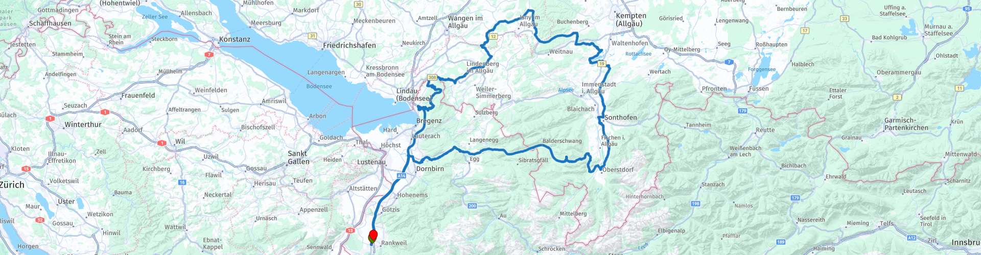
 This is the 5th route in my Vorarlberg circular tours collection.
This round trip takes you to Bregenz to the Pfänder and then to the beautiful Allgäu. The tour takes you over the legendary Riedberg Pass back to the Bregenzerwald and then back to the Rhine Valley.
Start and finish: Rankweil (gastronomy workshop)
Course: Rankweil - Lochau - Eichenberg - Lindenberg - Isny im Allgäu - Niedersonthofen - Sonthofen - Oberstdorf - Balderschwang - Hittisau - Dornbirn - Rankweil
The route is identical for TomTom, Garmin and MyRoute app.
If you drive this tour, please note the following information:
● Some mountain experience necessary
● In principle, the motorways in Austria are subject to tolls. However, the section between Bregenz and Hohenems is toll-free. In order to drive directly to Bregenz, I recommend buying a motorway vignette for Austria. (As of 2023 motorcycle: 10 days 5.80; 2 months 14.50)
● If you do not have a motorway vignette, drive from the start of the tour via the L190 to point 4. At the end of the tour, turn left after point 44 and drive again via the L190 to Rankweil.
I give this tour 5 stars. It offers everything that a great motorcycle tour needs. The high passes are missing, but the changing landscapes with their beautiful views and above all the fantastic roads will inspire you.
 Share this route


Animation

Verdict


Duration
6h 49m

Mode of travel
Car or motorcycle

Distance
237.63 km

Countries


 RouteXpert Review
 The tour then takes you on a small plateau to Möggers, before heading back down into the Leiblachtal shortly before Hohenweiler. You cross the border into Germany and branch off onto the famous German Alpine Road. After a short but winding section you will reach Scheidegg.
Shortly before Scheidegg you can make a stop to visit the Scheidegger waterfalls on a short hiking trail.
The Scheidegger Waterfalls are a popular destination for tourists and locals who want to enjoy nature and relax. The hiking trail is relatively easy to manage and offers many opportunities for photography and nature observation. The water of the Rickenbach falls over two mighty rock steps: the two waterfalls, which are close to each other, are 22 meters and 18 meters high. There are several viewing platforms along the way, which offer a spectacular view of the waterfalls and the Rohrach Gorge, which is up to 200 meters deep.
After a leisurely coffee break at the Schwarz bakery in Lindenberg, leave the Alpenstraße and the tour leads via Isny im Allgäu, to Wengen and Buchenberg. Shortly before Buchenberg you drive over a small hilltop to Niedersonthofen and the Niedersonthhofner See. Since the tour runs on side roads in the Allgäu, you will hardly have any traffic and can enjoy the ride to the fullest.
On the cozy terrace of Landgasthof Sonne, with a view of the lake, it's time for lunch. You will enjoy the obligatory coffee a little later.
After the lunch break, the Niedersonthofner See is circumnavigated and you continue to Sonthofen, to Oberstdorf. You can see the large Heini-Klopfer ski jumps in Oberstdorf from afar.
Just before the ascent to the Riedberg Pass begins, you have the opportunity to visit a 120 million year old cave. It was first discovered in 1929 by a farmer looking for a stray cow. The Sturmannshöhle is the only accessible fissure cave in the Allgäu. From a geological point of view, the Sturmanns Cave consists of Schrattenkalk, which was folded up millions of years ago during mountain formation in the Alps to form a more than 90 degree steep, longitudinal ellipse. Invading water and faults formed a 460 meter long gap along a vertical layer joint, of which almost 290 meters is accessible. The lighting in the Sturmannshöhle shines in modern LED light, which is also good for the inhabitants of the cave, especially the bats. An experience in the heart of the earth - all year round.
The ascent to the legendary Riedberg Pass follows. The Riedberg Pass is a very popular route for motorcyclists, as it is not only scenic, but also offers some challenges. The winding road requires concentration and skill, which is exactly what we motorcyclists want. That is why the Riedberg Pass is a popular destination for bikers from all over the world. As the saying goes - every motorcyclist must have cycled the Riedberg Pass once in their life.
Now it's time for the second coffee. Shortly after the Riedberg Pass, turn right, cross the large car park and park your motorbikes in front of the Grasgehren mountain hut. Berghütte Grasgehren is a cozy and rustic hut with a beautiful terrace. It offers spectacular views of the surrounding countryside and is ideal for a short break.
The onward journey to Balderschwang is just as spectacular as the ascent. Only shortly before Balderschwang does the road have fewer curves and you can cruise leisurely through the Bregenzerwald to Hittisau and on to Alberschwende. In Alberschwende you leave the main road and drive via Achrain to Dornbirn and then directly to Rankweil.


 Links
Links  Usage
Usage Want to download this route?
You can download the route for free without MyRoute-app account. To do so, open the route and click 'save as'. Want to edit this route?
No problem, start by opening the route. Follow the tutorial and create your personal MyRoute-app account. After registration, your trial starts automatically.  Disclaimer
Use of this GPS route is at your own expense and risk. The route has been carefully composed and checked by a MyRoute-app accredited RouteXpert for use on TomTom, Garmin and MyRoute-app Navigation.
Changes may nevertheless have occurred due to changed circumstances, road diversions or seasonal closures. We therefore recommend checking each route before use.
Preferably use the route track in your navigation system. More information about the use of MyRoute-app can be found on the website under 'Community' or 'Academy'.

Vorarlberg
About this region
Vorarlberg ( FOR-arl-burg, Austrian German: [foːɐ̯ˈarlbɛrk] (listen); Vorarlbergisch: Vorarlbearg, Voralbärg, or Voraadelbearg) is the westernmost state (Land) of Austria. It has the second-smallest geographical area after Vienna and, although it has the second-smallest population, it also has the second-highest population density (also after Vienna). It borders on three countries: Germany (Bavaria and Baden-Württemberg via Lake Constance), Switzerland (Grisons and St. Gallen), and Liechtenstein. The only Austrian state that shares a border with Vorarlberg is Tyrol, to the east.
The capital of Vorarlberg is Bregenz (29,698 inhabitants), although Dornbirn (49,845 inhabitants) and Feldkirch (34,192 inhabitants) have larger populations. Vorarlberg is also the only state in Austria in which the local dialect is not Austro-Bavarian, but rather an Alemannic dialect; it therefore has much more in common culturally with (historically) Alemannic-speaking German-speaking Switzerland, Liechtenstein, Swabia, and Alsace than with the rest of Austria, southeastern Bavaria, and South Tyrol.
Vorarlberg is to a large extent mountainous. About 37% (97,000 hectares) of its surface is forest.
Read more on Wikipedia
The capital of Vorarlberg is Bregenz (29,698 inhabitants), although Dornbirn (49,845 inhabitants) and Feldkirch (34,192 inhabitants) have larger populations. Vorarlberg is also the only state in Austria in which the local dialect is not Austro-Bavarian, but rather an Alemannic dialect; it therefore has much more in common culturally with (historically) Alemannic-speaking German-speaking Switzerland, Liechtenstein, Swabia, and Alsace than with the rest of Austria, southeastern Bavaria, and South Tyrol.
Vorarlberg is to a large extent mountainous. About 37% (97,000 hectares) of its surface is forest.
View region
 Statistics
  15
15Amount of RX reviews (Vorarlberg)
 16056
16056Amount of visitors (Vorarlberg)
 1232
1232Amount of downloads (Vorarlberg)
 Route Collections in this region
 The 24 Most Beautiful Alpine Routes
The Alps, The Alps are a mountain range in Europe, stretching from the French Mediterranean coast in the southwest to the Pannonian Plain in the east. The area of the mountain range is more than 200,000 km².
In other words Passes and Mountain Roads!
Driving through the mountains is great! Especially over the mountain passes with hairpin bends and narrow winding roads. Every bend a different view where you can enjoy. There are many beautiful mountain passes in the Alps.
A selection that has also been incorporated into these routes:
The Stlevio Pass:
The Stelvio Pass, also known as Passo dello Stelvio, is mainly known for the stage in the Giro d'Italia. Due to the length and the difference in height, this pass is seen as one of the toughest tests in cycling. The Stelvio Pass reaches a maximum height of 2758 meters and is therefore one of the highest in the Alps. The pass connects the towns of Bormio and Prato Allo Stelvio. In winter the pass is closed due to heavy snowfall.
The Reschenpass:
The Reschenpass, also known as Passo di Resia, connects the Austrian state of Tyrol with the Italian province of South Tyrol. The pass reaches a maximum height of 1,504 meters and has been one of the most important north-south connections in the Alps in recent centuries. The pass was used long before Roman times. Along the way you will pass several highlights and historical relics. One of the highlights is the Reschensee. This lake was created after the construction of the dam and has completely submerged the village of Graun. The only thing that reminds of that is the clock tower in the middle of the lake.
Col du Galibier:
The French mountain pass Col du Galibier connects the towns of Saint-Michel-de-Maurienne and Briançon via the Col du Lautaret in the south and the Col du Télégraphe in the north. The mountain pass is part of the Tour de France and very much feared, due to the fact that it can only be reached via the other two mountain passes. The pass reaches a maximum height of 2646 meters. From there you can take a walk to the viewpoint at 2704 meters. You can admire the peaks of the Grand Galibier, Mont Blanc and La Meije here.
The Grossglockner High Alpine Road:
With a height of 3798 meters the Grossglockner is the highest mountain in Austria. To fully enjoy this impressive mountain, you can drive over the Grossglockner High Alpine Road and the accompanying pass. The route starts from Bruck am Grossglockner and ends in Heiligenblut. Of course you can drive in two directions. The pass reaches a maximum height of 2504 meters and is closed in winter due to heavy snowfall. Along the way you pass several stops with fun activities, information points, mountain huts and viewpoints. A visit to the Kaiser-Franz-Josefs-Höhe and Pasterzen Glacier is highly recommended.
The Col d'Izoard:
Just like the Col du Galibier, the Col d'Izoard is also part of a stage of the Tour de France. The mountain pass connects Briançon with the valley of the river Guil. The pass is partly located in the Regional Natural Park du Queyras and reaches a maximum height of 2360 meters. What is special about the Col d'Izoard is the barren and rocky landscape. Sometimes it feels like driving a car over the moon! Along the way you can stop at several points to enjoy the beautiful view.
The Bernina Pass:
The Bernina Express is one of the most famous rail trains in Switzerland and the Alps. The route is beautiful and partly included on the UNESCO World Heritage List. Parallel to the railway lies the Bernina pass, which connects the Veltlin valley with the Egandin valley. This beautiful Alpine road has a total length of 56 kilometers and reaches a maximum height of 2328 meters. Along the way you can enjoy views of the Morteratsch Glacier.
The Sella Pass:
The Sella Pass, also known as Passo di Sella, takes you over one of the most impressive mountain ranges in the Dolomites: the Sella massif. The pass connects Valle di Fassa with Val Gardena and reaches a maximum height of 2236 meters. At this height is also the border of the Italian provinces of Trentino and Bolzano. Along the way you can enjoy the view of this spectacular mountain world. Admire, for example, the three peaks of the Sasso Lungo massif, the Sella massif or the peaks of the Marmolada. You can also drive the Sella pass in combination with the Gardena pass, Pordoi pass and Campolongo pass.
The Grimsel Pass:
The Grimsel Pass connects Goms in Wallis with the Halis Valley in the Bernese Oberland. The pass reaches a maximum elevation of 2165 meters and is closed in winter due to snowfall. Over the centuries, the mountain pass has played an important role in trade between Switzerland and Italy. Now it is mainly the reservoirs that have an important function. These are used to generate electricity. The landscape you drive through is rugged, rocky and impressive. On top of the pass is a hotel and a restaurant with a special marmot park. The Dodensee (Totensee) is also located here. This lake owes its name to the many soldiers who died in the time of Napoleon.
The Gotthard Pass:
The Gotthard Pass, also known as Passo del San Gottardo and Saint Gotthard, connects the Swiss towns of Airolo and Andermatt. The mountain pass and associated tunnel are especially known among holidaymakers driving from Switzerland to Italy. But where the majority opt for the tunnel, it is precisely the pass that really completes the holiday. The Gotthard Pass has a length of about 26 kilometers and reaches a maximum height of 2106 meters. The route is beautiful and takes you along old villages and beautiful views.
The Silvretta High Alpine Road and Silvretta Pass:
The Paznaun Valley in Tyrol and the Montafon in Vorarlberg are connected by the Silvretta High Alpine Road. The route has a length of 22.3 kilometers and leads from Galtür to Partenen in 34 hairpin bends, via the 2032 meter high Bielerhöhe. The Silvrettasee is also located at this point, where you can enjoy a lovely walk. The pass is closed in winter due to snowfall.
The Simplon Pass:
Just like the Gotthard Pass, many holidaymakers also travel over the Simplon Pass every year. This mountain pass connects the Rhone Valley in the canton of Valais with the Valle d'Ossola in Piemonte. The pass is open all year round and reaches a maximum height of 2005 meters. Along the way you pass a number of buildings, including the well-known Simplon Hospiz from 1825. The hospiz is managed by the monks of St. Bernard. From the highest point on the pass, all kinds of hiking routes are possible and you will also come across a hotel where you can spend the night.
The Gerlos Pass:
The Gerlos Pass connects the Salzach Valley in the Salzburgerland with the Zillertal Valley in Tyrol. The pass is part of the Gerlos Alpenstraße and runs right through the Hohe Tauern National Park. Along the way you can enjoy beautiful views of the surroundings. The pass has a length of 12 kilometers and reaches a maximum height of 1531 meters. A ride over the Gerlos Pass can be ideally combined with a visit to the Krimmler Wasserfälle.
The Great St. Bernard Pass:
The Great St. Bernard Pass, better known as Col du Grand Saint Bernard, connects the Italian province of Valle d'Aosta with the Swiss canton of Valais. The pass is one of the highest in Switzerland and reaches a maximum height of 2469 meters. Like a number of other mountain passes in this list, the Great St. Bernard Pass has also been used as a connecting road for centuries. The pass is named after the St. Bernard dogs that used to help stranded travelers along with the monks. The pass is closed in winter.
The Timmelsjoch High Alpine Road:
The Timmelsjoch High Alpine Road connects the towns of Sölden in the Ötztal and Meran in South Tyrol. Tolls must be paid on the Hochgurgl - Moos route. Via a mountain road with about 60 hairpin bends you drive through a beautiful mountain world. With the Timmelsjoch Experience you can learn more about the history, the road and the environment via various stations. You can also visit the Top Mountain Crosspoint museum.
Col de l'Iseran:
With a maximum pass height of 2770 meters, the Col l'Iséran is one of the highest mountain passes in the Alps. The pass connects Bourg-Saint-Maurice with Bonneval-sur-Arc. Via a road full of hairpin bends you pass, among other things, Val-d'Isère and a side valley of the Maurienne that lies entirely in the National Park de la Vanoise. You can spot animals such as marmots and chamois and there is also a restaurant with a chapel on top of the pass.
The Gavia Pass:
The Gavia Pass (Italian Passo di Gavia) is a mountain pass in the Italian Alps, in the Lombardy region.
It is one of the highest pass roads in Europe. The road leads through the unspoilt Stelvio National Park. The road was built in the First World War to supply Italian soldiers who fought in the Italian-Austrian border area. The pass height is one of the most beautiful in the Alps. Here is the large Lago Bianco with, to the north, the mountain San Matteo (3684 meters). Lago Nero is slightly lower on the south side of the pass. Here the mountain group of the Adamello determines the view. There are many well-marked walks in the area. During the winter the pass is closed due to the heavy snowfall. The pass is often closed until May and June due to the large amount of snow.
Promoter has made a selection of the 24 Most Beautiful Alpine routes that they have set out in recent years.
The routes go through:
France
Austria
Switzerland
Italy
The most beautiful roads, the most beautiful views, the most beautiful viewpoints. The highest mountains, the fastest descents, hairpin bend after hairpin bend, you name it you can't get enough of it.
If you go on holiday in this region, take advantage of it, ALL routes in this collection have been checked and made equal for TomTom, Garmin and MyRoute-app Navigation by a MyRoute-app RouteXpert.
Have fun with this collection and while driving one of these routes. Enjoy all the beauty that the Alps and the Dolomites have to offer. Click on “View route” to read the review of the chosen route.
I would like to hear your findings about the route(s).
View Route Collection
11 day trip from the Netherlands
8 countries in 11 days; The Netherlands, Germany, Austria, Italy, Switzerland, France, Luxembourg and Belgium. This route collections consists of 10 routes that I have driven with friends in the summer of 2019.
The start is in Geldermalsen Netherlands, the first 7 days you drive through the Netherlands, Germany, Austria, Italy, Switzerland, France and a piece of Luxembourg with overnight stays in hotels.
The last three days you stay in Barweiler (D) in the Eifel and you drive two beautiful tours through the Eifel, Luxembourg and parts of the Belgian Ardennes.
There is no highway in the routes, only beautiful provincial and country roads, many beautiful passes with beautiful panoramas.
Be sure to check whether the passes are open before you leave.
These are routes for experienced drivers.
View Route Collection