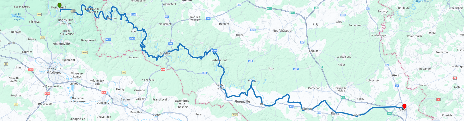
to the Source de Semois from Montherme

This route was brought to you by:
RouteXpert Jan Koelstra (jan cabrio)
Last edit: 27-01-2025
 Route Summary
 During this ride you follow the river from the mouth to the source and are treated to the most beautiful views of spectacular river loops. Regularly you descend to water level to cross the river. A good opportunity for a stop in one of the cozy villages along the river.
This route gets four stars for its spectacular viewpoints on the many meanders it makes. In addition, many charming villages along the Semois offer a romantic view. Whether you like history, nature or gastronomy, there is something for everyone in this region of Belgium.
 Share this route


Animation

Verdict


Duration
7h 16m

Mode of travel
Car or motorcycle

Distance
154.09 km

Countries


 RouteXpert Review
 The material into which the Semois cuts itself is mainly slate. This metamorphic rock was originally clay that was deposited in the Middle Siegenian (Early Devonian). The best-known place on the Semois is the medieval town of Bouillon with its castle. Downstream, traces can be seen of the tobacco cultivation that characterised the Semois valley until the middle of the 20th century and to which a museum is dedicated in Vresse. The Semois is popular with anglers who catch barbel, nase, chub and pike there.
In this trip you follow the river in the opposite direction of the current. You start in Monthermé and end in Arlon. The distance from the source to the mouth is only 70 km as the crow flies, but the total length of the river is almost three times that because of the many meanders.
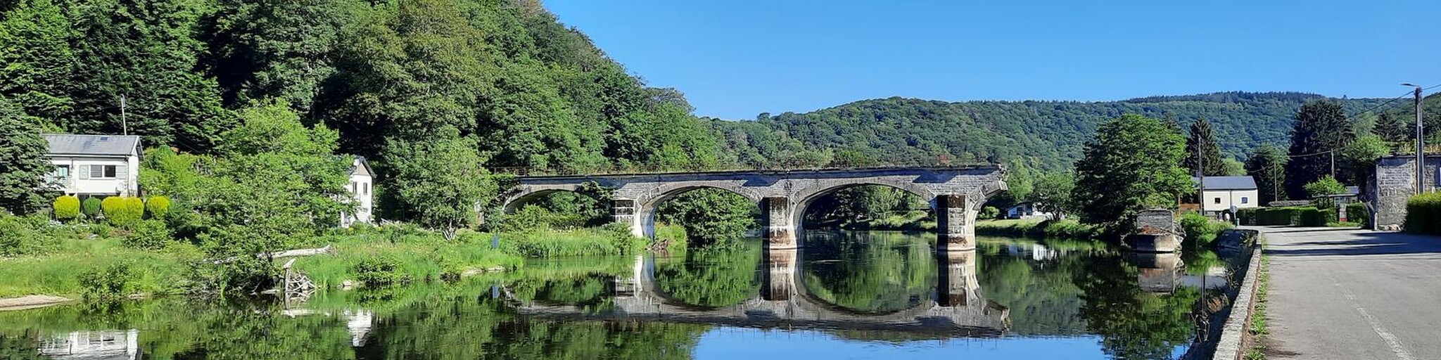
The town of Monthermé is located about 10 kilometers from the Belgian border, in the Grand Est region. Formerly called Champagne-Ardennes, it has been merged with the regions of Lorraine and Alsace since 2016. It is located in the Parc Naturel Régional des Ardennes (or simply: the French Ardennes) and is therefore great for outdoor activities. It is located on both the Meuse and the Semoy rivers; you can go canoeing and fishing. In Monthermé itself there are a few historical sights to be found, including the Église Saint-Léger, a church with parts dating back to the 12th century. The abbey church of Laval-Dieu is also worth a visit. There are also a lot of events organized. For an overview of them, go to the tourist office on the Place Jean Baptiste Clément. Right next door is a boulangerie with delicious croissants and baguettes: Le Fournil du Baraquin to load up for the road.
Monthermé lived from the exploitation of the forest, slate quarries, nails and shipping on the Meuse. From 1749 to 1846, a glass factory was in operation on the site of the Laval Dieu Abbey. Then, at the end of the 19th century, the metallurgical industry followed. Favourably situated at the confluence of the Meuse and the Semoy, it supplies sheet metal and wrought iron to the nail and bolt factories in the area. Nearby, on the left bank of the Semoy, a foundry is located at a place called "le Champ du Trou" which manufactures "Monthermé" stoves and a little further upstream, in the hamlet of Phades, it is a factory of rolled galvanised sheets.
Founded by the canons of Prémontré in the 14th century, the abbey of Laval-Dieu has undergone numerous modifications following the devastation caused by enemy crossings in this border area. Today, there remains the listed abbey church with beautiful woodwork.
Tournavaux is the next village on the Semoy. Here nature is the main influence on the village. The 'Roche aux Corpias', or the raven rock, overlooks the beautiful Semoy with its charming meanders. But as nice as it may look, the river can be merciless. The inhabitants of Tournavaux will not easily forget it. At the end of the nineteenth century, the water rose above the first floor of their houses.
There is a former medieval fortress near the village of Thilay, the Château de Linchamps, the ruins of which are still visible. Originally built in the 12th century and renovated in the 16th century. Destroyed by the royal troops in the mid-16th century, it was then rebuilt by the Duke of Guise before undergoing a major restructuring and being destroyed again in the second half of the 17th century. Today, the Château de Linchamps lies in an abandoned state on a rocky outcrop and is largely overgrown.
In Bohan you cross the border with Belgium. Bohan is situated in a kind of valley but it is certainly worth the effort to make the climb to the top. From here you will find a large number of panoramic spots with appealing names: La Croix, Le Jambon and Les Huit Semois. The village of Membre is a short distance away. This old centre of tobacco cultivation is recognisable in the summer by the high stems with hard, slightly hairy leaves. The tobacco of the Semois is used to make fairly strong shag and a rather hard type of cigar. Around Membre there are still drying sheds for tobacco.
Between Membre and Bohan you will find the spectacular remains of a local railway line that functioned normally for barely 5 years. On both sides, the bridges over the Semois were bombed and are still a monument to that past. The connecting tunnel became a paradise for bats, but was recently restored and is back in use as a cycle tunnel. The Membre-Bohan site is unique on the former local railway network with its handful of tunnels and where viaducts of this size are just as rare, unlike many secondary networks, for example in neighbouring France and in Italy.
The viewpoint Le Jambon de la Semois is one of the most beautiful viewpoints on the Semois! The name of this place is immediately clear when you get there. The shape of the river and the land reminds you of a large ham.
The village of Vresse-sur-Semois has an important tourist function, because there are quite a few sights nearby. There is a beautiful replica of the first locomotive of Belgium from 1835 "Le Belge". In real size and completely in wood. This is a beautiful reconstruction of the locomotive La Belge, the oldest locomotive of Belgium.
The Pont de Claies is a special bridge over the Semois. It is a temporary bridge that can only be used in the summer. It is built and dismantled every year. This has been done for centuries and the tradition is maintained. Construction begins in June and the bridge is removed at the end of September. When the bridge is ready, someone comes by every day to check that everything is still in order. The bridge is made of woven panels of birch and hazel branches! Le Pont de Claies can be found in the village of Laforêt, one of the most beautiful villages in Wallonia. In the past, a lot of tobacco was grown in this region. When the water level was low, it was decided to build a bridge. This allowed the tobacco growers to reach the agricultural lands along the river without a detour. This saved the people who worked on the land a lot of time.
With its three irregular arches and situated in the beautiful greenery, the Saint-Lambert bridge is the calling card of Vresse. When the bridge was built and by whom, is lost in history.
In the village of Alle, slate is the main focus. Bluestone makes you dream and many people are unaware that the Ardennes were the first to discover and exploit it. At the top of the charming and lively village of Alle-sur-Semois, the mine provided the livelihood of the families in the region for decades. The company closed its doors in 1948 after the successful development of foreign and modern production. In 2012, it was decided to give the mine a new lease of life as a tourist site and to exploit the abandoned Ardois'Alle cave.
Towards Rochehaut you will come across the panorama of Frahan and the meander of the Semois. In the restaurant at the lookout point, coffee is ready.
A few villages further on, the valley suddenly opens up and there is Bouillon with its quay, stately homes and the legacy of Godfrey: the castle. The town is no longer as rich and important as it was in the Middle Ages, but you can still feel its allure. The name alone: Bouillon. Godfrey of Bouillon. Super knight, hero of the Ardennes and official Protector of the Holy Sepulchre. The fact that he left his homeland at the end of the 11th century to liberate Jerusalem from hostile Muslims with his crusaders appeals to the imagination. The Ducal Museum (Musée Ducal), housed in two buildings from the 18th century and close to the Castle of Bouillon, has a magnificent collection including Islamic art and medieval art. The archaeology of the region is also discussed and the iron industry is highlighted. The museum also pays a lot of attention to Godfrey of Bouillon and you can admire souvenirs from the crusades such as weapons and religious objects from that period.
Passing viewpoints here and there, you will pass the charming hamlet of Mortehan with a remarkable cemetery on the banks of the Semois.
In Herbeumont, a peaceful and at the same time touristic village, where the ruins of a medieval castle offer a beautiful view of the Semois, it is time to eat. At the crossroads in the village there are a few nice places.
Today, only a few traces remain of this once very powerful fortress on a steep hill, which was supposedly impregnable. But they do bear witness to a tumultuous past. The building from 1268 was inhabited by many illustrious family dynasties over the centuries. In 1657, it was destroyed by French troops.
In Chassepierre, with a stream of the same name in the centre of the village, was covered in the 19th century. In the past, the water of the Chassepierre powered the mills and fed the wash houses located along the slopes of the village, between the presbytery and the church. Unfortunately demolished in 1980, it nevertheless allowed the discovery of the remains of a much older occupation of the site and its geological origins, nicely called the “fairy well”: a network of galleries dug by man in the limestone, which extends to the cellars of the presbytery and forms a mysterious network.
The main attractions of Chiny are the sturdy Saint-Nicolas Bridge over the Semois and the private castle of Villemont.
From here the Semois becomes less winding, because the area here is less hilly. The landscape gradually becomes more charming. The Saint Walburgis church (1829) with abstract stained glass windows by Louis-Marie Londot and a painted Stations of the Cross by Louis Lecomte. In the forest of Chiny live deer, European mouflons and wild boars.
Along the way you will pass Château du Faing, a castle in the district of Jamoigne. Now in use as a town hall. The road also takes you past a brewery in Breuvanne, brasserie Artisanale Millevertus, to taste something.
Then the end point quickly comes into view. Arlon is one of the three oldest cities in Belgium. As befits an old city, it has narrow streets in its center. You can stroll through the old quarter, discover the charming site of Saint-Donat, and enjoy a beautiful panorama from the Belvedere.
The sources of the Semois are located in the rue Sonnetty. They are situated where two ponds from the 17th and 18th centuries were discovered. These structures belonged to nearby tanneries.
The research into the location of the springs is due to the Arlon Tourist Office. The search was started between 1967 and 1970. Barely 2 years later, in 1972, the springs were inaugurated. Since then, a copy of a fragment of a Roman monument has stood here. It refers to the Gallo-Roman past of Aelonn and reminds visitors of the importance of water since Antiquity.


 Links
Links  Usage
Usage Want to download this route?
You can download the route for free without MyRoute-app account. To do so, open the route and click 'save as'. Want to edit this route?
No problem, start by opening the route. Follow the tutorial and create your personal MyRoute-app account. After registration, your trial starts automatically.  Disclaimer
Use of this GPS route is at your own expense and risk. The route has been carefully composed and checked by a MyRoute-app accredited RouteXpert for use on TomTom, Garmin and MyRoute-app Navigation.
Changes may nevertheless have occurred due to changed circumstances, road diversions or seasonal closures. We therefore recommend checking each route before use.
Preferably use the route track in your navigation system. More information about the use of MyRoute-app can be found on the website under 'Community' or 'Academy'.
;_vue_de_la_partie_occidentale_du_château-fort_(XIIIe–XIX_siècles).jpg/1280px-Bouillon_(Belgique);_vue_de_la_partie_occidentale_du_château-fort_(XIIIe–XIX_siècles).jpg)
Luxembourg
About this region
Luxembourg (French: Luxembourg [lyksɑ̃buʁ] (About this soundlisten); Dutch: Luxemburg [ˈlyksəmˌbʏrx] (About this soundlisten); German: Luxemburg [ˈlʊksəmbʊʁk] (About this soundlisten); Luxembourgish: Lëtzebuerg; Walloon: Lussimbork), also called Belgian Luxembourg, is the southernmost province of Wallonia and of Belgium. It borders on the country of Luxembourg to the east, the French departments of Ardennes, Meuse and Meurthe-et-Moselle to the south and southwest, and the Walloon provinces of Namur and Liège to the north. Its capital and largest city is Arlon (Luxembourgish: Arel, Dutch: Aarlen), in the south-east of the province.
It has an area of 4,459 km2 (1,722 sq mi), making it the largest Belgian province. With around 285,000 residents, it is also the least populated province, with a density of 64/km2 (170/sq mi), making it a relatively sparsely settled part of a very densely populated region.
It is significantly larger (70%), but much less populous than the neighbouring Grand Duchy of Luxembourg. About eighty percent of the province is part of the densely wooded Ardennes region. The southernmost region of the province is called Gaume or Belgian Lorraine (main city: Virton).
The Arelerland or Arlon region (in red on the map of arrondissements, below) bordering the neighbouring Grand-Duchy of Luxembourg has the particularity that many of its residents have historically spoken Luxembourgish, a language closely related to German, rather than the French or Walloon spoken elsewhere in the province.
The province was separated from the neighbouring Luxembourg by the Third Partition of Luxembourg, de jure in 1830–31 by the Conference of London dealing with the consequences of the Belgian Revolution of 1830, de facto in 1839, after William I, King of the Netherlands and Grand-Duke of Luxembourg, agreed to its decisions and thus the province was given to the newly created Kingdom of Belgium.
Read more on Wikipedia
It has an area of 4,459 km2 (1,722 sq mi), making it the largest Belgian province. With around 285,000 residents, it is also the least populated province, with a density of 64/km2 (170/sq mi), making it a relatively sparsely settled part of a very densely populated region.
It is significantly larger (70%), but much less populous than the neighbouring Grand Duchy of Luxembourg. About eighty percent of the province is part of the densely wooded Ardennes region. The southernmost region of the province is called Gaume or Belgian Lorraine (main city: Virton).
The Arelerland or Arlon region (in red on the map of arrondissements, below) bordering the neighbouring Grand-Duchy of Luxembourg has the particularity that many of its residents have historically spoken Luxembourgish, a language closely related to German, rather than the French or Walloon spoken elsewhere in the province.
The province was separated from the neighbouring Luxembourg by the Third Partition of Luxembourg, de jure in 1830–31 by the Conference of London dealing with the consequences of the Belgian Revolution of 1830, de facto in 1839, after William I, King of the Netherlands and Grand-Duke of Luxembourg, agreed to its decisions and thus the province was given to the newly created Kingdom of Belgium.
View region
 Statistics
  39
39Amount of RX reviews (Luxembourg )
 22621
22621Amount of visitors (Luxembourg )
 8243
8243Amount of downloads (Luxembourg )
 Route Collections in this region
 Route collection MRA NAVIGATION GRAND TOUR 2019
MRA NAVIGATION GRAND TOUR 2019 in short:
From 2019, MyRoute-app organizes every year the "MyRoute-app Navigation Grand Tour" exclusively for MyRoute-app Navigation users. During the Grand Tour you drive 4 routes during the calendar year. A few commands are included in each route. Participants who capture all 4 tracks via MyRoute-app Navigation have the chance to win a great prize. In 2019 we had chosen the 2nd World War as the theme for the 4 routes.
The routes and the assignments:
As mentioned, the theme of 2019 was the 2nd World War. A loaded theme, you are confronted with the dual nature of humanity; the willingness to kill for an ideology, we are better than them, cruelty, slaughter, but also heroism and sacrifices, would it ever change? I myself am very interested in world history, I have even studied it for a year at the university and certainly the 1st and 2nd world war have my interest. So it was no task to put together the routes, drive yourself and come up with the assignments.
Have fun driving these beautiful and interesting routes with a loaded theme!
View Route Collection
5 tours in Belgium in flat Flanders the hills of the Pays des Collines and the Ardennes
Those who like a winding and hilly course, along many small lanes with little to no traffic, will certainly find what they are looking for in the Pays des Collines, the region east and south of Ronse.
Between Diksmuide and Ypres there are many commemorative monuments of the First World War. In Vinkt in East Flanders, the monument commemorates the massacre that took place in May 1940.
Along rural quiet roads you can taste the history of World War I and II.
Marche-en-Famenne is an excellent starting point to thoroughly explore this plateau, which is cut by rivers and strewn with coniferous forests. The real Ardennes are the most hilly areas of Belgium behind the Meuse. Nature plays an all-important role on this trip.
In addition to the Ardennes, the route with start and end point in Huy also goes through a part of Condroz and Famenne. The Condroz, where wooded hills and valleys alternate, and the Famenne, which makes the transition to the Ardennes plateaus. In the summer it is wonderful motorcycling in the vast forests. You will not only enjoy the natural beauty, but you will also pass numerous castles, wild flowing Ardennes rivers, quiet villages and authentic tourist towns.
The tour from Namur runs through the Meuse area where you discover that the tributaries of the Meuse are of picturesque beauty. You will pass a large number of castles and fortresses. The roads along the Maas are busy arterial roads. But as soon as you can you will look for the smaller roads that are immediately a lot quieter and take us through forests and meadows.
View Route Collection