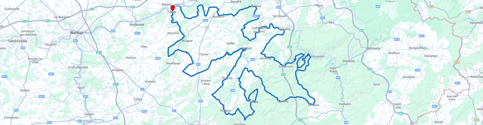
Roundtrip through the hinterland of Huy

This route was brought to you by:
RouteXpert Catherine De Groote RouteXpert
Last edit: 01-05-2021
 Route Summary
 In the summer, motorcycling is beautiful in the vast forests. The route follows winding dual carriageways. A small part of the route is on very small quiet secondary roads.
You will not only enjoy the natural beauty, but you will also pass numerous castles, wildly flowing Ardennes rivers, quiet villages and authentic tourist towns. Because a number of secondary roads are in less good condition on this ride, I give 4 stars here.
 Share this route


Animation

Verdict


Duration
9h 32m

Mode of travel
Car or motorcycle

Distance
288.70 km

Countries

 RouteXpert Review
 At the top of the hill is the castle 'Tour au Bois'. It is a beautiful castle on the place where originally a building called "Tour â Boys" stood. This name refers to the name of the family that inhabited it. For several decades, French nuns turned it into a girls' school.
Saint-Séverin is worth a stop: you should definitely visit the abbey church. The 12th-century former abbey church provides a beautiful image, not only because of its purity, but also because of its surroundings, a peaceful square with lots of greenery. You can also see a few things inside. The octagonal dome betrays the influence of the Rhineland, where this architectural style was not uncommon.
The road to Nandrin offers some beautiful viewpoints. Via the two-lane road along the Esneux forest you arrive in the town of the same name where the Ourthe makes a big bend. In Poulseur you leave the Ourthe. The road surface is not so good in the forest. A pity because it is nevertheless quiet driving along the narrow road.
In Anthines you will come across one of the most remarkable monuments. The Avouerie (the residence of the ecclesiastical representative) is a unique and beautiful building. Dating from the 12th century (keep), the building has a curious military character. The living area dates back to the 17th century and contains a museum as well as an exhibition on beer, which can be tasted in the cellars.
Open from January 1 to December 31, 2020: every day, except Monday, from 10 a.m. to 6 p.m.
Visit with tasting. Free for children under 6 years old. Guided tours for groups of at least 20 people (by reservation). Entrance price: € 6.00 pp.
From Hamoir, the Ourthe is your regular companion to Aywaille. This small town gives a pleasant impression as a traffic junction and the resulting activities: shops, cafes and restaurants of all kinds. Aywaille also has some very old buildings such as St. Peter's Church (11th century), some old houses in rue Hongrée and a few mills whose origins date back to the early Middle Ages.
The road continues to wind until you cross the E25 motorway. A little further you drive back into the forest. Here too the track is narrow and in some places of poor quality. You now cross the Parc naturel des Sources where you pass the 'Sources minérales de Chevron'. This source has been known since ancient times. In 1903, the first industrial exploitation of Chevron waters bottling was created. In 2001 the factory was moved to Lorcé. The water from this source is marketed under the name Bru. There are many small rivers in this area.
After Chession you get a beautiful view of the region on the plateau. Forests and open spaces alternate.
You can take a break at the 'Relais de Pêcheurs' in Chevron. You enter a kind of snack bar, but at the back is 'the restaurant'.
The ride now follows the winding Lienne. The Lienne is a tributary of the Amblève that has its source at an altitude of 540 meters near Lierneux (which you will pass within a few kilometers). It winds its way almost due north through the Ardennes to end at Targnon at an altitude of 190 meters in the Amblève.
In Manhay, a visit to the MHM 44 museum is highly recommended. It was opened in December 2017. Thanks to the sets of historical sites that have been precisely reconstructed, this museum about the Second World War will introduce you to this painful period in history. The museum is dedicated to American units that fought in Manhay, an episode in the Battle of the Bulge, in December 1944 and January 1945.
Open daily 10 am-6pm - closed on Tuesdays - Open every day in July and August: 10am - 6pm
Entrance price: € 7.50 pp.
Opposite the museum is a German Panther Mark V tank that was part of the 2nd SS Panzer Division. The tank was abandoned in a pasture in December 1944.
Via Bomal-sur-Ourthe you arrive in Barvaux. This is a busy holiday center that offers options for a hearty bite to eat.
In the hinterland of Huy, the dolmens of Wéris form a kind of small Stonehenge. The menhir Danthine stands on the edge of the main road from Érezée to Barvaux and has a height of 3.60 m and weighs 8 tons. The menhir originally stood in the "Champ de la Longue Pierre" but was moved 130 m by the archaeologist Hélène Danthine in 1947.
You are now driving through the valley of the Aisne. A rather small, but very authentic sloping landscape with Ardennes villages, small-scale agriculture and forests.
When you leave the tourist Érezée, you come a little further past the castle of Blier. It is somewhat hidden behind the trees. The original castle dates from the 16th century. It underwent remarkable transformations in the 19th century and the whole was considerably strengthened at the beginning of the 20th century. The main tower bears the coat of arms of the Blier family with the motto "virtute et fortuna" (the power of birth and fortune). A second castle was built at the end of the courtyard in the 2nd half of the 19th century. The castle is now a hotel restaurant.
In the square in front of Beffe church is an American M4 Sherman tank, a local reminder of the Battle of the Bulge. You can park your motorcycle in the parking lot opposite the church. On the other corner you can enjoy a snack or a drink on the terrace of brasserie Beffelyhills.
Just outside Hampteau, turn left at the entrance to an old quarry. Here you make a small detour along the caves of One Thousand and One Nights. The caves were only discovered in 1958 and immediately exploited for tourism.
The caves were created because rainwater infiltrated the limestone plateau and eventually returned to the earth's surface via an underground river at Hampteau in the course of Ourthe. Today, about six kilometers of tunnels are known to a depth of about 70 meters below the plateau. In the lowest part, the underground river flows continuously. In the cave there are several rooms, the largest being the large gallery with a maximum height of 35 meters, a width of 10 meters and a length of 200 meters.
Open from April to October: every day from 10am to 5pm (6pm in July and August) - from November to March: guided tours at fixed times on weekends - during the Christmas and Carnival holidays: guided tours every day.
Price: € 10.00 pp
Before entering Hotton, you pass a large Commonwealth military cemetery where more than 600 soldiers are buried who died in heavy fighting in the Battle of the Bulge.
Hotton has a beautiful location in the Ardennes. The river Ourthe runs right through the center and is therefore the center of many water sports in summer. From the terraces on the water you can watch the toiling kayakers.
From there you continue to Durbuy. This medieval town has stood the test of time well. Its round shape reveals that the river once completely flowed around it.
Shops, restaurants and hotels have displaced the original inhabitants, causing Durbuy to lose some of its authenticity. Despite this, it is a beautiful place with a lot of charm: small narrow cobblestone streets, a castle that towers above the town, not to mention its picturesque location in the valley of the Ourthe.
The town is particularly popular with visitors from the Netherlands and Flanders; on busy days you hear more Dutch than French in the streets. All information boards are nicely displayed in Dutch, French and English and you will be helped with a smile in fluent Dutch. There is a motorcycle parking on the other side of the Ourthe.
The castle is one of the most prominent sights of Durbuy. The first was built in the 11th century and was fortified in the 13th century when Durbuy had to help defend the northern borders of the county of Luxembourg. In the 18th century, the castle came into the hands of the important noble d'Ursel family who had it renovated in 1731. The current view was created after a restoration around 1880. The domain is still owned by the d'Ursel family.
Durbuy is located on the border of Condroz and Famenne and quite quickly the typical landscape of the Condroz appears with its variety of meadows, fields and dense forests. Here you can enjoy the panoramic view of the region. In Les Avins you drive on the Hoyoux, a tributary of the Meuse.
Many villages are dominated by monumental farms that can best be described as a cross between a fortified castle and a lavish country house.
You will soon arrive at the castle of Sainte-Fontaine. It is surrounded by a beautiful park and overlooks the Ossogne Valley. The facade recalls the construction dates: 1635 on the north flank and 1692 on the west flank. The facade overlooking the courtyard was renovated around 1900. The castle is crowned with a terracotta balustrade that continues on all sides.
A few kilometers further, the course winds through the forests of Tharoul and Bouhenière and you follow the river Le Hoyoux. Along the national road 641 you arrive in the hamlet of Barse. At the foot of the ruins of the fortress, which was destroyed in 1314, stands the farm-castle of Vieux-Barse from the 17th century. This large square limestone farmhouse has three corner towers.
After a few more turns you will return to Huy. On the Maas you turn left where there is a motorcycle parking.
The center is largely pedestrianized. Here you can reminisce about your ride with a nice meal or a drink.
In addition to the Gothic collegiate church, there are also many cozy little streets behind the town hall. The architectural heritage includes the town hall (18th century), the 14th-century Gothic Bethlehem portal, the 15th-century Sint-Mengold church and numerous beautiful patrician houses.
The Huy fortress is located on the banks of the Maas and dominates the city. This is definitely worth a visit. The fort was built between 1818 and 1823 on the site of the old castle, the "Tchestia" which was destroyed in 1717. From May 1940 to September 5, 1944, the Germans converted the Fort into a prison camp guarded by the Wehrmacht (German army) and controlled by the Geheime Feldpolizei (secret military police). More than 7,000 prisoners of various nationalities were imprisoned.
Today the Fort is a memorial of the Second World War.
Open: April, May, June, September and October: weekdays from 9.30am to 5pm. Weekends and public holidays from 10am to 6pm.
In July and August: daily from 10am to 6pm.
Entrance fee: € 4.00 pp. Free visit every 1st Sunday of the month and on July 21st.
The landscape is very varied. You drive through dense forests as well as open landscapes and along numerous rivers. There is certainly no lack of opportunities to eat something. Many of the Ardennes towns and villages are tourist attractions with restaurants and brasseries. You will pass numerous castles and castle farms as well as some monuments and memories of the Battle of the Bulge. Because a number of secondary roads are in less good condition on this ride, I give 4 stars here.


 Links
Links  Usage
Usage Want to download this route?
You can download the route for free without MyRoute-app account. To do so, open the route and click 'save as'. Want to edit this route?
No problem, start by opening the route. Follow the tutorial and create your personal MyRoute-app account. After registration, your trial starts automatically.  Disclaimer
Use of this GPS route is at your own expense and risk. The route has been carefully composed and checked by a MyRoute-app accredited RouteXpert for use on TomTom, Garmin and MyRoute-app Navigation.
Changes may nevertheless have occurred due to changed circumstances, road diversions or seasonal closures. We therefore recommend checking each route before use.
Preferably use the route track in your navigation system. More information about the use of MyRoute-app can be found on the website under 'Community' or 'Academy'.

Wallonia
About this region
The Walloon Region (French: Région wallonne [ʁeʒjɔ̃ walɔn]; German: Wallonische Region; Dutch: Waals gewest), usually simply referred to as Wallonia (; French: Wallonie [walɔni]; Walloon: Waloneye; German: Wallonien [vaˈloːni̯ən] (listen) or Wallonie [valoˈniː]; Dutch: Wallonië [ʋɑˈloːnijə] (listen)), is one of the three Regions of Belgium—alongside the Flemish Region and the Brussels-Capital Region.Covering the southern portion of the country, Wallonia is primarily French-speaking, and accounts for 55% of Belgium's territory, but only a third of its population. The Walloon Region was not merged with the French Community of Belgium, which is the political entity responsible for matters related mainly to culture and education, because the French Community of Belgium encompasses both Wallonia and the bilingual Brussels-Capital Region.
There is a German-speaking minority in eastern Wallonia, resulting from the annexation of three cantons previously part of the German Empire at the conclusion of World War I. This community represents less than 1% of the Belgian population. It forms the German-speaking Community of Belgium, which has its own government and parliament for culture-related issues.
During the industrial revolution, Wallonia was second only to the United Kingdom in industrialization, capitalizing on its extensive deposits of coal and iron. This brought the region wealth, and from the beginning of the 19th to the middle of the 20th century, Wallonia was the more prosperous half of Belgium. Since World War II, the importance of heavy industry has greatly diminished, and the Flemish Region has exceeded Wallonia in wealth as Wallonia has declined economically. Wallonia now suffers from high unemployment and has a significantly lower GDP per capita than Flanders. The economic inequalities and linguistic divide between the two are major sources of political conflicts in Belgium and a major factor in Flemish separatism.
The capital of Wallonia is Namur, and the most populous city is Charleroi. Most of Wallonia's major cities and two-thirds of its population lie along the east-west aligned Sambre and Meuse valley, the former industrial backbone of Belgium. To the north of this valley, Wallonia lies on the Central Belgian Plateau, which, like Flanders, is a relatively flat and agriculturally fertile area. The south and southeast of Wallonia is made up of the Ardennes, an expanse of forested highland that is less densely populated.
Wallonia borders Flanders and the Netherlands (the province of Limburg) in the north, France (Grand Est and Hauts-de-France) to the south and west, and Germany (North Rhine-Westphalia and Rhineland-Palatinate) and Luxembourg (Capellen, Clervaux, Esch-sur-Alzette, Redange and Wiltz) to the east. Wallonia has been a member of the Organisation Internationale de la Francophonie since 1980.
Read more on Wikipedia
There is a German-speaking minority in eastern Wallonia, resulting from the annexation of three cantons previously part of the German Empire at the conclusion of World War I. This community represents less than 1% of the Belgian population. It forms the German-speaking Community of Belgium, which has its own government and parliament for culture-related issues.
During the industrial revolution, Wallonia was second only to the United Kingdom in industrialization, capitalizing on its extensive deposits of coal and iron. This brought the region wealth, and from the beginning of the 19th to the middle of the 20th century, Wallonia was the more prosperous half of Belgium. Since World War II, the importance of heavy industry has greatly diminished, and the Flemish Region has exceeded Wallonia in wealth as Wallonia has declined economically. Wallonia now suffers from high unemployment and has a significantly lower GDP per capita than Flanders. The economic inequalities and linguistic divide between the two are major sources of political conflicts in Belgium and a major factor in Flemish separatism.
The capital of Wallonia is Namur, and the most populous city is Charleroi. Most of Wallonia's major cities and two-thirds of its population lie along the east-west aligned Sambre and Meuse valley, the former industrial backbone of Belgium. To the north of this valley, Wallonia lies on the Central Belgian Plateau, which, like Flanders, is a relatively flat and agriculturally fertile area. The south and southeast of Wallonia is made up of the Ardennes, an expanse of forested highland that is less densely populated.
Wallonia borders Flanders and the Netherlands (the province of Limburg) in the north, France (Grand Est and Hauts-de-France) to the south and west, and Germany (North Rhine-Westphalia and Rhineland-Palatinate) and Luxembourg (Capellen, Clervaux, Esch-sur-Alzette, Redange and Wiltz) to the east. Wallonia has been a member of the Organisation Internationale de la Francophonie since 1980.
View region
 Statistics
  95
95Amount of RX reviews (Wallonia)
 26609
26609Amount of visitors (Wallonia)
 21387
21387Amount of downloads (Wallonia)
 Route Collections in this region
 The 10 most beautiful car and motorcycle routes in Limburg
Limburg, who thinks of Limburg, thinks of flan, coal mines, marl and the hill country. The coal mines have been closed for almost 40 years, the last load of coal was brought up from the Oranje-Nassau coal mine in Heerlen on 31 December and, as they say, South Limburg was transformed from Black to Green and unfortunately there is still little left. view of this period.
But not only pie, marl and coal in Limburg, but also a very beautiful province to tour by car or motorcycle and enjoy all the beauty that the province of Limburg has to offer. For this, the MyRoute app RouteXpert has put together a Top 10 of Car and Motorcycle routes for you.
All routes in this collection have been checked and made equal for TomTom, Garmin and MyRoute-app Navigation by a MyRoute-app RouteXpert.
If you think, I have a very nice route that should certainly not be missing from this collection, send it to:
email: routeexpert@myrouteapp.com
Subject: New Route for the Top 10 collection Province of Limburg composed by Hans van de Ven.
The route will then be reviewed and then added to the Top 10.
To make the Top 10 also the Top 10, 1 route will have to disappear from the Top 10, you can indicate this when submitting the new route.
Have fun with this collection and while driving one of these routes. Enjoy all the beauty that the Netherlands and in particular the province of Limburg has to offer. Click on “View route” to read the review of the chosen route.
I would like to hear your findings about the route(s).
View Route Collection
Top 5 Car and Motorcycle Routes in the Eifel
The Eifel is the eastern part of the medium plateau Eifel-Ardennes. It is located north of the Moselle and west of the Rhine. The largest part is in Germany, a small part is in Belgium, in the East Cantons. The German part of Eifel is located in the federal states of North Rhine-Westphalia and Rhineland-Palatinate. The highest point is the Hohe Acht with 747 meters.
Several chains can be distinguished in the Eifel:
The northernmost part is called the Nordeifel, which in Belgium connects to the High Fens;
To the east of this is the Ahrgebirge, this part is located north of the Ahr in the Ahrweiler district;
South of the Ahr is the Hohe Eifel (or Hocheifel), of which the Hohe Acht (747 m) is the highest point, and also the highest point in the entire Eifel region;
To the west, near the Belgian border, the hills are known as Schneifel, part of the wider Snow Eifel area with peaks reaching up to 698 metres;
South and east of the Hohe Eifel is the Volcano-Eifel, a volcanic area with many crater lakes (Maare).
The southern part of the Eifel is less high. The area is bisected by streams and rivers running southwards. These streams flow into the Moselle. The largest of these rivers is the Kyll; the hills around this river are known as the Kyllwald;
In the south, the Eifel ends in the Voreifel.
In the north of the Eifel there are some large reservoirs. The largest of these is the reservoir in the Roer that was created by the construction of the Roerdal dam.
The Nürburgring is also located in the Eifel, a well-known car circuit for Formula 1 races, among other things. Since 2004, part of the north of the Eifel has become the Eifel National Park. This National Park falls entirely within the German-Belgian nature park High Fens-Eifel. Another part of the Eifel falls within the South Eifel Nature Park.
Well-known throughout the Netherlands and Belgium by car and motorcyclists, so reason enough for the MyRoute app RouteXpert to compile a Top 5 of Car and Motorbike routes for you.
All routes in this collection have been checked and made equal for TomTom, Garmin and MyRoute-app Navigation by a MyRoute-app RouteXpert.
If you think, I have a very nice route that should certainly not be missing from this collection, send it to:
email: routeexpert@myrouteapp.com
Subject: New Route for the Top 5 collection Eifel composed by Hans van de Ven.
The route will then be reviewed and then added to the Top 5. To make the Top 5 also the Top 5, 1 route will have to disappear from the Top 5, you can indicate this when submitting the new route.
Have fun with this collection and while driving one of these routes. Enjoy all the beauty that the Eifel has to offer. Click on “View route” to read the review of the chosen route.
I would like to hear your findings about the route(s).
View Route Collection