Roundtour Col de Vars Col de la Bonnette

This route was brought to you by:
RouteXpert Peter Moerman - RouteXpert
Last edit: 13-09-2021
 Route Summary
 On the way you will pass a beautiful reservoir which you also cross via a long bridge.
It is a long route, so start on time. The roads are fine and you can enjoy driving on large parts.
The Cols are not very difficult to ride but do have some sharp hairpin bends where you have to be careful.
We have driven this route and variations on it several times ourselves in recent years and enjoy the beautiful and varied surroundings again and again.
I give this route 4.5 stars because of the attractive environment and the excellent and challenging roads.
This route is part of a series of routes in this area, all starting from a great motorcycle hotel.
 Share this route


Animation

Verdict


Duration
10h 12m

Mode of travel
Car or motorcycle

Distance
392.64 km

Countries

 RouteXpert Review
 The Drôme department is part of the Auvergne-Rhône-Alpes region. It is bordered by the departments of Ardèche, Isère, Hautes-Alpes, Alpes-de-Haute-Provence and Vaucluse. The canton of Valréas, called Enclave des papes until the French Revolution, belongs to the department of Vaucluse, but is completely surrounded by the department of Drôme.
The department takes its name from the river Drôme, a tributary of the Rhône, with a length of 110 km.
Hautes-Alpes is surrounded by the departments of Alpes-de-Haute-Provence, Drôme, Isère and Savoie as well as by Italy.
It is a very mountainous department. Of all the French departments, it has the highest average height above sea level, above 1,000 m. The highest point is at 4,101 meters. Only 3 agglomerations really claim to be cities, viz. Gap, Briançon and Embrun (sub-prefecture until 1926). The village of Saint-Véran, the highest village in France, is located at an altitude of 2042 meters. Gap is the highest-lying prefecture in France, and Briançon the highest-lying sub-prefecture.
Alpes-de-Haute-Provence is surrounded by the departments of Alpes-Maritimes, Var, Vaucluse, Drôme and Hautes-Alpes as well as by Italy. Important city: Manosque, largest city in the department, although not even a sub-prefecture.
Watercourses: Durance, Verdon, Bléone, Ubaye, Var, Buëch, Jabron, Largue. The Verdon (regional nature park) lies on the border with the Var department.
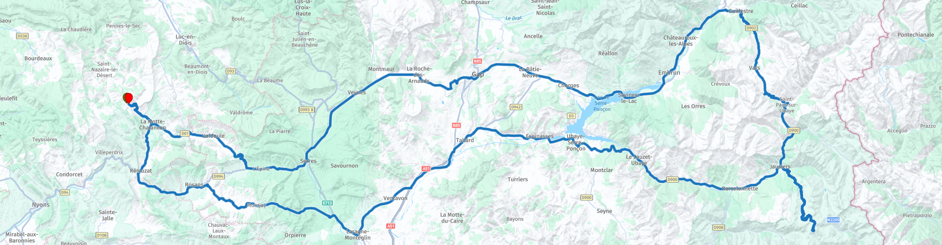
The route starts and ends at the village of Chalancon at Motovacances Chamauche, a great base for exploring this region. From the start it goes straight down to La Motte de Chalancon. After about 14 kilometers you drive past a geological site that was only discovered in 1977 and where all kinds of rocks can be seen.
The route continues through a valley towards the Col de Tourettes where it pays to get off and enjoy the view from both sides. Driving up the beautiful curves with excellent asphalt is always a pleasure for motorcyclists. The descent is a bit more careful because there are some blind corners. After the descent you turn left onto the D994, a somewhat boring road but great to continue for a while to gain some time. It is advisable not to skip the refueling stop because you won't find many petrol stations in this region.
The route continues towards Gap, the capital of the Hautes Alpes department. Here you can score a delicious cup of coffee with a sandwich at the bakery. Furthermore, we did not find the city really worthwhile and because of the number of kilometers still to be driven, it is better to spend your time on the view of the next highlight, Lac de Seres-Ponçon.
This reservoir is bordered on one side by a gigantic dam, which you have the opportunity to view later in the day. As the second largest artificial lake in Europe, Lake Serre-Ponçon, with an area of 3000 hectares, is a wonderful water surrounded by mountain reliefs. A real sea in the mountains! Numerous activities can be practiced, both on water and on land. To enjoy the beautiful viewpoints on the site of Serre-Ponçon, hikers should certainly not ignore the hiking trails that cross the surroundings of this vast, turquoise water. The impressive Serre-Ponçon dam, built on the Durance, is, with a height of 123 meters and a length of 650 meters at the base, the largest earth dam in Europe! To visit: the Museoscope of the Lake, located at the viewpoint of Serre-Ponçon in Rousset, which allows you to delve into the history and construction of this immense dam.
Further on you cross the lake at Savines le Lac and continue towards Guillestre. Located at the gates of the Queyras Regional Natural Park, between the Vars Pass and the Izoard Pass, the town of Guillestre has a beautiful religious heritage. Built in country stones, the Gothic Assomption Church is decorated with a remarkable portal whose columns rest on reclining lions. Its three-storey clock tower is adorned with a beautiful sundial. Guillestre has also preserved old houses and remains of the fortress from its past, as evidenced by the remains of the city walls and the four gates. Lovers of regional products will not fail to head for the Guillestre market on Monday morning.
From Guillestre the first climb towards Col de Vars starts with some beautiful hairpin bends. There is another scheduled refueling stop halfway through. On top of the Col de Vars at 2109 meters there is a parking lot and catering. The descent starts again with a few hairpin bends and continues to Jausier.
If you are pressed for time, you can decide to skip the Col de La Bonette here. You make an unforgivable mistake that you will regret for years to come. So don't and just turn left towards Nice. The road quickly rises out of the village via a number of hairpin bends. You will pass Restaurant Halte 2000. You can now stop for lunch or on the way back during the descent. The road meanders between the masses of stone and the number of trees decreases as you approach the tree line. Hairpin bends every time so that your view is different every time. The landscape is getting rougher and barren until there are only rocks and bare slopes around you. Fear of heights is not really a feature you can use here, but luckily the road is wide enough to pass. On the way up you will also pass Fortin de Resteford, an inaccessible military establishment.
At the crossing of the Col de La Bonette, just drive straight ahead and drive around the top. The monument is at the highest point. Here is a parking lot and you are at an altitude of 2802 meters, the almost highest asphalt point in Europe. If you want to go even higher, go to the top on foot, where you have a fantastic 360-degree view of the surroundings. So now you can check something off your bucket list again.
The two kilometer long road around the Cime de la Bonette, a side road from the Col de la Bonette, is one of the highest paved roads in the Alps. The road reaches a height of 2802 meters and is often, incorrectly, classified as the highest paved road in the Alps, but the Austrian Ötztaler Gletscherstraße reaches up to 2829 meters, which is higher. Strictly speaking, the road around the Cime de la Bonette is not a col, but it is the highest point of the Alps that can be reached via two different roads.
The descent follows the same way back to Jausiers. If you are in dire need, you can stop here for a sanitary stop in the parking lot just after the exit towards Barcelonette. There are a number of attractions in this town. Musee de la Vallee is a regional museum and Vila Bleue is a historic villa with special architecture. There is also a possible refueling stop if you missed the previous one. The route continues back towards the Lac de Serres-Ponçon. At the indicated vantage point you again have a beautiful view over the lake. After this you descend to the reservoir and pass the canal De Sisteron EDF. At the roundabout you can choose to turn left towards the last coffee stop or you can turn right and drive 5 km up to the largest dam in Europe. Here is a nice viewpoint with information boards about its construction.
From the parking lot, turn back towards the roundabout and you will soon reach the last coffee stop at Hotel La Poste. After this, the mind is at zero and the gas is on towards the end of the route. Don't forget to fill up your tank for the next day in Remuzat. In the cozy village of La Motte de Chalancon you can score a cup of coffee or you can drive straight up the mountain to Chamauche where a nice cold beer or a cool glass of wine will be waiting for you.


 Links
Links  Usage
Usage Want to download this route?
You can download the route for free without MyRoute-app account. To do so, open the route and click 'save as'. Want to edit this route?
No problem, start by opening the route. Follow the tutorial and create your personal MyRoute-app account. After registration, your trial starts automatically.  Disclaimer
Use of this GPS route is at your own expense and risk. The route has been carefully composed and checked by a MyRoute-app accredited RouteXpert for use on TomTom, Garmin and MyRoute-app Navigation.
Changes may nevertheless have occurred due to changed circumstances, road diversions or seasonal closures. We therefore recommend checking each route before use.
Preferably use the route track in your navigation system. More information about the use of MyRoute-app can be found on the website under 'Community' or 'Academy'.

Auvergne Rhone Alpes
About this region
Auvergne-Rhône-Alpes (ARA; French: [ovɛʁɲ ʁon‿alp] (listen); Arpitan: Ôvèrgne-Rôno-Ârpes; Occitan: Auvèrnhe Ròse Aups; Italian: Alvernia-Rodano-Alpi) is a region in southeast-central France created by the 2014 territorial reform of French regions; it resulted from the merger of Auvergne and Rhône-Alpes. The new region came into effect on 1 January 2016, after the regional elections in December 2015.The region covers an area of 69,711 km2 (26,916 sq mi), making it the third largest in metropolitan France; it had a population of 7,948,287 in 2017, second to Île-de-France. It consists of twelve departments and one territorial collectivity (Lyon Metropolis) with Lyon as the prefecture.
This new region combines diverse geographical, sociological, economic and cultural regions, which was already true of Rhône-Alpes, as well as Auvergne, to a lesser extent. While the old Rhône-Alpes and Auvergne regions each enjoyed a unity defined by axes of communication and the pull of their respective metropoles, the new combination is heterogeneous; it sustained lively opposition from some local officials after its creation.
Read more on Wikipedia
This new region combines diverse geographical, sociological, economic and cultural regions, which was already true of Rhône-Alpes, as well as Auvergne, to a lesser extent. While the old Rhône-Alpes and Auvergne regions each enjoyed a unity defined by axes of communication and the pull of their respective metropoles, the new combination is heterogeneous; it sustained lively opposition from some local officials after its creation.
View region
 Statistics
  118
118Amount of RX reviews (Auvergne Rhone Alpes)
 45072
45072Amount of visitors (Auvergne Rhone Alpes)
 5427
5427Amount of downloads (Auvergne Rhone Alpes)
 Route Collections in this region
 The 24 Most Beautiful Alpine Routes
The Alps, The Alps are a mountain range in Europe, stretching from the French Mediterranean coast in the southwest to the Pannonian Plain in the east. The area of the mountain range is more than 200,000 km².
In other words Passes and Mountain Roads!
Driving through the mountains is great! Especially over the mountain passes with hairpin bends and narrow winding roads. Every bend a different view where you can enjoy. There are many beautiful mountain passes in the Alps.
A selection that has also been incorporated into these routes:
The Stlevio Pass:
The Stelvio Pass, also known as Passo dello Stelvio, is mainly known for the stage in the Giro d'Italia. Due to the length and the difference in height, this pass is seen as one of the toughest tests in cycling. The Stelvio Pass reaches a maximum height of 2758 meters and is therefore one of the highest in the Alps. The pass connects the towns of Bormio and Prato Allo Stelvio. In winter the pass is closed due to heavy snowfall.
The Reschenpass:
The Reschenpass, also known as Passo di Resia, connects the Austrian state of Tyrol with the Italian province of South Tyrol. The pass reaches a maximum height of 1,504 meters and has been one of the most important north-south connections in the Alps in recent centuries. The pass was used long before Roman times. Along the way you will pass several highlights and historical relics. One of the highlights is the Reschensee. This lake was created after the construction of the dam and has completely submerged the village of Graun. The only thing that reminds of that is the clock tower in the middle of the lake.
Col du Galibier:
The French mountain pass Col du Galibier connects the towns of Saint-Michel-de-Maurienne and Briançon via the Col du Lautaret in the south and the Col du Télégraphe in the north. The mountain pass is part of the Tour de France and very much feared, due to the fact that it can only be reached via the other two mountain passes. The pass reaches a maximum height of 2646 meters. From there you can take a walk to the viewpoint at 2704 meters. You can admire the peaks of the Grand Galibier, Mont Blanc and La Meije here.
The Grossglockner High Alpine Road:
With a height of 3798 meters the Grossglockner is the highest mountain in Austria. To fully enjoy this impressive mountain, you can drive over the Grossglockner High Alpine Road and the accompanying pass. The route starts from Bruck am Grossglockner and ends in Heiligenblut. Of course you can drive in two directions. The pass reaches a maximum height of 2504 meters and is closed in winter due to heavy snowfall. Along the way you pass several stops with fun activities, information points, mountain huts and viewpoints. A visit to the Kaiser-Franz-Josefs-Höhe and Pasterzen Glacier is highly recommended.
The Col d'Izoard:
Just like the Col du Galibier, the Col d'Izoard is also part of a stage of the Tour de France. The mountain pass connects Briançon with the valley of the river Guil. The pass is partly located in the Regional Natural Park du Queyras and reaches a maximum height of 2360 meters. What is special about the Col d'Izoard is the barren and rocky landscape. Sometimes it feels like driving a car over the moon! Along the way you can stop at several points to enjoy the beautiful view.
The Bernina Pass:
The Bernina Express is one of the most famous rail trains in Switzerland and the Alps. The route is beautiful and partly included on the UNESCO World Heritage List. Parallel to the railway lies the Bernina pass, which connects the Veltlin valley with the Egandin valley. This beautiful Alpine road has a total length of 56 kilometers and reaches a maximum height of 2328 meters. Along the way you can enjoy views of the Morteratsch Glacier.
The Sella Pass:
The Sella Pass, also known as Passo di Sella, takes you over one of the most impressive mountain ranges in the Dolomites: the Sella massif. The pass connects Valle di Fassa with Val Gardena and reaches a maximum height of 2236 meters. At this height is also the border of the Italian provinces of Trentino and Bolzano. Along the way you can enjoy the view of this spectacular mountain world. Admire, for example, the three peaks of the Sasso Lungo massif, the Sella massif or the peaks of the Marmolada. You can also drive the Sella pass in combination with the Gardena pass, Pordoi pass and Campolongo pass.
The Grimsel Pass:
The Grimsel Pass connects Goms in Wallis with the Halis Valley in the Bernese Oberland. The pass reaches a maximum elevation of 2165 meters and is closed in winter due to snowfall. Over the centuries, the mountain pass has played an important role in trade between Switzerland and Italy. Now it is mainly the reservoirs that have an important function. These are used to generate electricity. The landscape you drive through is rugged, rocky and impressive. On top of the pass is a hotel and a restaurant with a special marmot park. The Dodensee (Totensee) is also located here. This lake owes its name to the many soldiers who died in the time of Napoleon.
The Gotthard Pass:
The Gotthard Pass, also known as Passo del San Gottardo and Saint Gotthard, connects the Swiss towns of Airolo and Andermatt. The mountain pass and associated tunnel are especially known among holidaymakers driving from Switzerland to Italy. But where the majority opt for the tunnel, it is precisely the pass that really completes the holiday. The Gotthard Pass has a length of about 26 kilometers and reaches a maximum height of 2106 meters. The route is beautiful and takes you along old villages and beautiful views.
The Silvretta High Alpine Road and Silvretta Pass:
The Paznaun Valley in Tyrol and the Montafon in Vorarlberg are connected by the Silvretta High Alpine Road. The route has a length of 22.3 kilometers and leads from Galtür to Partenen in 34 hairpin bends, via the 2032 meter high Bielerhöhe. The Silvrettasee is also located at this point, where you can enjoy a lovely walk. The pass is closed in winter due to snowfall.
The Simplon Pass:
Just like the Gotthard Pass, many holidaymakers also travel over the Simplon Pass every year. This mountain pass connects the Rhone Valley in the canton of Valais with the Valle d'Ossola in Piemonte. The pass is open all year round and reaches a maximum height of 2005 meters. Along the way you pass a number of buildings, including the well-known Simplon Hospiz from 1825. The hospiz is managed by the monks of St. Bernard. From the highest point on the pass, all kinds of hiking routes are possible and you will also come across a hotel where you can spend the night.
The Gerlos Pass:
The Gerlos Pass connects the Salzach Valley in the Salzburgerland with the Zillertal Valley in Tyrol. The pass is part of the Gerlos Alpenstraße and runs right through the Hohe Tauern National Park. Along the way you can enjoy beautiful views of the surroundings. The pass has a length of 12 kilometers and reaches a maximum height of 1531 meters. A ride over the Gerlos Pass can be ideally combined with a visit to the Krimmler Wasserfälle.
The Great St. Bernard Pass:
The Great St. Bernard Pass, better known as Col du Grand Saint Bernard, connects the Italian province of Valle d'Aosta with the Swiss canton of Valais. The pass is one of the highest in Switzerland and reaches a maximum height of 2469 meters. Like a number of other mountain passes in this list, the Great St. Bernard Pass has also been used as a connecting road for centuries. The pass is named after the St. Bernard dogs that used to help stranded travelers along with the monks. The pass is closed in winter.
The Timmelsjoch High Alpine Road:
The Timmelsjoch High Alpine Road connects the towns of Sölden in the Ötztal and Meran in South Tyrol. Tolls must be paid on the Hochgurgl - Moos route. Via a mountain road with about 60 hairpin bends you drive through a beautiful mountain world. With the Timmelsjoch Experience you can learn more about the history, the road and the environment via various stations. You can also visit the Top Mountain Crosspoint museum.
Col de l'Iseran:
With a maximum pass height of 2770 meters, the Col l'Iséran is one of the highest mountain passes in the Alps. The pass connects Bourg-Saint-Maurice with Bonneval-sur-Arc. Via a road full of hairpin bends you pass, among other things, Val-d'Isère and a side valley of the Maurienne that lies entirely in the National Park de la Vanoise. You can spot animals such as marmots and chamois and there is also a restaurant with a chapel on top of the pass.
The Gavia Pass:
The Gavia Pass (Italian Passo di Gavia) is a mountain pass in the Italian Alps, in the Lombardy region.
It is one of the highest pass roads in Europe. The road leads through the unspoilt Stelvio National Park. The road was built in the First World War to supply Italian soldiers who fought in the Italian-Austrian border area. The pass height is one of the most beautiful in the Alps. Here is the large Lago Bianco with, to the north, the mountain San Matteo (3684 meters). Lago Nero is slightly lower on the south side of the pass. Here the mountain group of the Adamello determines the view. There are many well-marked walks in the area. During the winter the pass is closed due to the heavy snowfall. The pass is often closed until May and June due to the large amount of snow.
Promoter has made a selection of the 24 Most Beautiful Alpine routes that they have set out in recent years.
The routes go through:
France
Austria
Switzerland
Italy
The most beautiful roads, the most beautiful views, the most beautiful viewpoints. The highest mountains, the fastest descents, hairpin bend after hairpin bend, you name it you can't get enough of it.
If you go on holiday in this region, take advantage of it, ALL routes in this collection have been checked and made equal for TomTom, Garmin and MyRoute-app Navigation by a MyRoute-app RouteXpert.
Have fun with this collection and while driving one of these routes. Enjoy all the beauty that the Alps and the Dolomites have to offer. Click on “View route” to read the review of the chosen route.
I would like to hear your findings about the route(s).
View Route Collection
25 Magnificent trails in France
This MRA route collection contains 25 beautiful motorcycle routes in different parts of France, such as the Ardennes, the Alsace, Vercors, the Drôme, the Ardèche, Cote d'Azure, Gorges du Verdon, the Ariège, the Dordogne and Brittany.
The routes have been carefully created by Bert Loorbach, who is an enthusiastic motorcyclist himself. He lived in France for a year and a half, during which time he devoted himself to mapping the unknown and beautiful back roads of France especially for motorcyclists.
The routes are bundled in the Motortourgids France part 1 of Kosmos publishing house and now also available in MyRouteApp.
I have taken over the routes in MRA and sometimes adjusted them slightly to make them even more interesting for the motorcyclist.
View Route Collection