Roundtour Gran Canaria day 1 West

This route was brought to you by:
RouteXpert Arno van Lochem - Senior RX
Last edit: 21-12-2021
 Route Summary
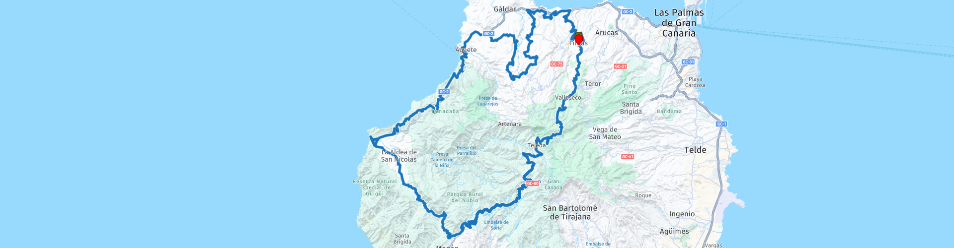
 The start of the route is in the small town of El Risco. The route is mainly on the smaller, beautiful roads, which are provided with good asphalt. You really have to do your best to find a straight piece, it is all bends that you will encounter in the route. Assume that the straps will be used completely! After almost 180 kilometers you will return to El Risco.
The route is for the more advanced motorcyclist. Certainly the second part requires good engine management given the (tight!) Hairpin bends.
Sights along the way include Cenobio de Valerón, Museo de la Rama, Cactualdea Park, Los Azulejos and a few places with a great view.
Because of the beautiful roads, the fantastic landscape and the nice sights I rate this route with 5 stars.
 Share this route


Animation

Verdict


Duration
9h 13m

Mode of travel
Car or motorcycle

Distance
223.59 km

Countries

 RouteXpert Review
 Enjoy high quality roads with little traffic, spectacular views and endless curves. The landscape is so varied that you will never get bored. It is an absolute paradise for motorcyclists!
The route starts in El Risco, a small town located fairly north on Gran Canaria. You will soon leave the built-up area and meander through the beautiful landscape. Right swinging, there is almost no straight to discover here. You haven't gone through one bend yet or the next one is already coming up, it doesn't stop.
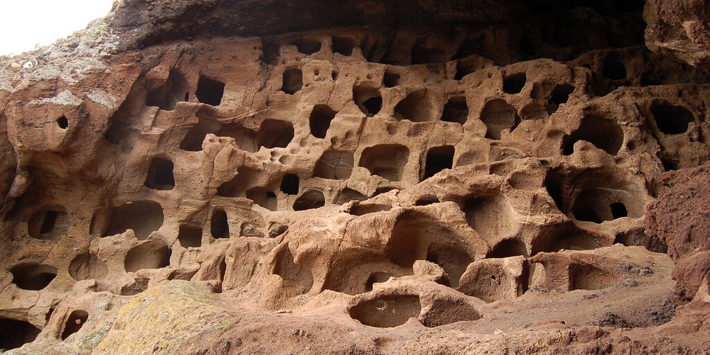
The first ten kilometers you drive to the north, soon you see the sea looming. For a short time you drive parallel to the water, until you come to Cenobio de Valerón. This is a spectacular Aboriginal barn of a collective character. Located on a high mountainside of Mount Gallego, is this site that the ancient inhabitants built more than 500 years ago, taking advantage of the geological conditions of the volcanic cone. In it, and aided by stone peaks, more than 350 cavities were opened, which are located on different levels and were used as storage of grain and other foodstuffs.
The strategic character of this location makes it a real natural fortress, unnoticed from the outside and set in an almost vertical mountain wall.
The image of the caves and the surrounding towering cliffs leave unforgettable memories for visitors, who can learn about the ancient inhabitants who have lived here over the centuries.
You continue the route while winding along the GC-291, which soon turns into the GC-70. Via this road you drive through the interior of Gran Canaria, which is not a punishment at all. Nice villages, beautiful views and pieces of forest alternate, you don't have to be bored for a moment. What is striking is the beautiful asphalt you drive over, the Spaniards know how to build roads!
Arriving in Agaete you have the opportunity to visit the Museo de La Rama. La Rama (the branch) takes center stage during the celebrations of the 'Virgen de Las Nieves' in Agaete. Over the years, this event has developed into one of the most important summer festivals in the Canary Islands. It is not just any celebration, but has great symbolism for the people of Gran Canaria. In 1972, the festivities were therefore declared a festival of national tourist importance.
In the Museo de La Rama you can taste the essence of this celebration every day of the year. The museum gives a picture of the various elements that play a role at the party. From the 'papagüevos', giant carnivalesque dolls, to the various decorations on the feast and the branches that gave the feast its name. The museum is located in a specially designed building with six different exhibition areas.
After Agaete you descend south along the coast. The road you drive on is great again. No straight to discover, beautiful views are presented to you after every bend. Sometimes also a view over the sea, in short, enjoy! After about 15 kilometers it is time to interrupt this beauty for a well-deserved cup of coffee.
After the coffee, the party is not over yet, the swinging continues for another 20 kilometers. What a punishment! In between all this driving force, don't forget to stop at the many beautiful places with fantastic views.
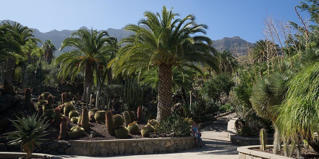
Just south of La Aldea de San Nicolás you pass the Cactualdea Park, the largest cactus park in Europe. A cactus with palm trees, aloes, peacocks and turtles. Six meters. This is how much the tallest cactus of Cactualdea Park measures, the indisputable protagonist of the best pictures that this incredible garden bestows. And so it is common that, when entering the largest cactus park in Europe, one is surprised at the sheer size of the many specimens of the more than 1200 species that make their home here. An area of 15,000 square meters in La Aldea de San Nicolás in western Gran Canaria that can be crossed in a smooth and enjoyable one hour walk.
Cactualdea offers much more than just spiny plants from exotic places like Madagascar. Between the rippling water, just past the amphitheater, the artificial volcano erupts towards the steps leading to the beautiful garden. A large stone path runs through the cacti where an infinite number of cacti can be discovered surrounded by palm trees, aloes and cardoons while free roaming peacocks, ducks, turtles and donkeys look on carelessly. Then comes the visit to the cave and of course some snacks in the bar or buy souvenirs.
After the cacti you drive over the only mountain pass that is rich on this route, the Degollada de la Aldea with a height of 658 meters. Although this height is of course not much in the world of passes, you still have an impressive view from this pass.
After this pass you wind along Los Azulejos to the lunch place. While most people won't spend hours at the unusual rock formation of Los Azulejos, a short visit is highly recommended.
The rock formation of Los Azulejos is located along the road from Mogán to San Nicolás de Tolentino about 10 km from Mogán. The rocks owe their name Los Azulejos to the special colors they display. These resemble the colors of the well-known Portuguese tiles, the azulejos. When you look at the rocks you will notice many different shades, from blue to green and dark red. These differences are the result of oxidation. The color palette of Los Azulejos offers an impressive view.
At the restaurant where lunch is planned you will also come across a small museum that has been filled by the owner of the restaurant over the years. Housed in a typical Canarian house, the museum allows restaurant patrons to learn about the customs and tools used by herders, farmers and people of the island. From old bicycles to one of the first switchboards, but also documents, bottles, implements and agricultural tools. Nice to stroll through!
After lunch you swing north again and via one more coffee stop you reach El Risco after 180 kilometers, where the route also started. Also in this last part there are a number of places directly on the route where you really have to stop to enjoy the view for a moment to realize what a beautiful island Gran Canaria is.
Have fun driving this route!
 Links
Links  Usage
Usage Want to download this route?
You can download the route for free without MyRoute-app account. To do so, open the route and click 'save as'. Want to edit this route?
No problem, start by opening the route. Follow the tutorial and create your personal MyRoute-app account. After registration, your trial starts automatically.  Disclaimer
Use of this GPS route is at your own expense and risk. The route has been carefully composed and checked by a MyRoute-app accredited RouteXpert for use on TomTom, Garmin and MyRoute-app Navigation.
Changes may nevertheless have occurred due to changed circumstances, road diversions or seasonal closures. We therefore recommend checking each route before use.
Preferably use the route track in your navigation system. More information about the use of MyRoute-app can be found on the website under 'Community' or 'Academy'.

Canary Islands
About this region
The Canary Islands (; Spanish: Canarias, pronounced [kaˈnaɾjas]), also known informally as the Canaries, is a Spanish archipelago in the Atlantic Ocean, in a region known as Macaronesia. At their closest point to the African mainland, they are 100 kilometres (62 miles) west of Morocco. They are the southernmost of the autonomous communities of Spain, and are located in the African Tectonic Plate. The archipelago is economically and politically European, and is part of the European Union.The eight main islands are (from largest to smallest in area) Tenerife, Fuerteventura, Gran Canaria, Lanzarote, La Palma, La Gomera, El Hierro and La Graciosa. The archipelago includes many smaller islands and islets, including Alegranza, Isla de Lobos, Montaña Clara, Roque del Oeste, and Roque del Este. It also includes a number of rocks, including those of Salmor, Fasnia, Bonanza, Garachico, and Anaga. In ancient times, the island chain was often referred to as "the Fortunate Isles". The Canary Islands are the southernmost region of Spain, and the largest and most populous archipelago of Macaronesia. Because of their location, the Canary Islands have historically been considered a bridge between the four continents of Africa, North America, South America, and Europe.In 2019, the Canary Islands had a population of 2,153,389, with a density of 287.39 inhabitants per km2, making it the eighth most populous autonomous community of Spain. The population is mostly concentrated in the two capital islands: around 43% on the island of Tenerife and 40% on the island of Gran Canaria.
The Canary Islands, especially Tenerife, Gran Canaria, Fuerteventura, and Lanzarote, are a major tourist destination, with over 12 million visitors per year. This is due to their beaches, tropical to subtropical climate, and important natural attractions, especially Maspalomas in Gran Canaria, Teide National Park, and Mount Teide (a World Heritage Site) in Tenerife. Mount Teide is the highest peak in Spain and the third tallest volcano in the world, measured from its base on the ocean floor. The islands have warm summers and winters warm enough for the climate to be technically tropical at sea level. The amount of precipitation and the level of maritime moderation vary depending on location and elevation. The archipelago includes green areas as well as desert areas. The islands’ high mountains are ideal for astronomical observation, because they lie above the temperature inversion layer. As a result, the archipelago boasts two professional observatories: Teide Observatory on the island of Tenerife, and Roque de los Muchachos Observatory on the island of La Palma.In 1927, the Province of Canary Islands was split into two provinces. In 1982, the autonomous community of the Canary Islands was established. The cities of Santa Cruz de Tenerife and Las Palmas de Gran Canaria are, jointly, the capital of the islands. Those cities are also, respectively, the capitals of the provinces of Santa Cruz de Tenerife and Las Palmas. Las Palmas de Gran Canaria has been the largest city in the Canaries since 1768, except for a brief period in the 1910s. Between the 1833 territorial division of Spain and 1927, Santa Cruz de Tenerife was the sole capital of the Canary Islands. In 1927, it was ordered by decree that the capital of the Canary Islands would be shared between two cities, and this arrangement persists to the present day. The third largest city in the Canary Islands is San Cristóbal de La Laguna (a World Heritage Site) on Tenerife. This city is also home to the Consejo Consultivo de Canarias, which is the supreme consultative body of the Canary Islands.During the Age of Sail, the Canaries were the main stopover for Spanish galleons on their way to the Americas, which sailed that far south in order to catch the prevailing northeasterly trade winds.
Read more on Wikipedia
The Canary Islands, especially Tenerife, Gran Canaria, Fuerteventura, and Lanzarote, are a major tourist destination, with over 12 million visitors per year. This is due to their beaches, tropical to subtropical climate, and important natural attractions, especially Maspalomas in Gran Canaria, Teide National Park, and Mount Teide (a World Heritage Site) in Tenerife. Mount Teide is the highest peak in Spain and the third tallest volcano in the world, measured from its base on the ocean floor. The islands have warm summers and winters warm enough for the climate to be technically tropical at sea level. The amount of precipitation and the level of maritime moderation vary depending on location and elevation. The archipelago includes green areas as well as desert areas. The islands’ high mountains are ideal for astronomical observation, because they lie above the temperature inversion layer. As a result, the archipelago boasts two professional observatories: Teide Observatory on the island of Tenerife, and Roque de los Muchachos Observatory on the island of La Palma.In 1927, the Province of Canary Islands was split into two provinces. In 1982, the autonomous community of the Canary Islands was established. The cities of Santa Cruz de Tenerife and Las Palmas de Gran Canaria are, jointly, the capital of the islands. Those cities are also, respectively, the capitals of the provinces of Santa Cruz de Tenerife and Las Palmas. Las Palmas de Gran Canaria has been the largest city in the Canaries since 1768, except for a brief period in the 1910s. Between the 1833 territorial division of Spain and 1927, Santa Cruz de Tenerife was the sole capital of the Canary Islands. In 1927, it was ordered by decree that the capital of the Canary Islands would be shared between two cities, and this arrangement persists to the present day. The third largest city in the Canary Islands is San Cristóbal de La Laguna (a World Heritage Site) on Tenerife. This city is also home to the Consejo Consultivo de Canarias, which is the supreme consultative body of the Canary Islands.During the Age of Sail, the Canaries were the main stopover for Spanish galleons on their way to the Americas, which sailed that far south in order to catch the prevailing northeasterly trade winds.
View region
 Statistics
  8
8Amount of RX reviews (Canary Islands)
 12858
12858Amount of visitors (Canary Islands)
 309
309Amount of downloads (Canary Islands)
 Route Collections in this region
 Exploring the magnificent roads of Gran Canaria in three days
Nog een weekje vakantie tegoed? En het snertweer zat? Op vier uur vliegen is het, in tegenstelling tot het wisselvallige Nederlandse weer, altijd zomer. En Gran Canaria kan dan wel bekend staan om de massa's zonaanbidders, het blijkt ook een waar walhalla voor de motorrijder!
Deze drie routes zijn prima in één weekend of midweek te rijden. Ze brengen je naar alle hoeken van het eiland waar het maar enigszins interessant is om te rijden. En laten we eerlijk zijn, dat is bijna het hele eiland! Laat je overweldigen door de fantastische krullende wegen, voorzien van strak asfalt, die over het eiland zijn aangelegd, laat je verrassen door de verborgen schatten die aan het massatoerisme voorbij gaan.
Op het eiland zijn meerdere verhuurders van motoren aanwezig waaronder Motor Rental Bike en Pic Y Poc. Voor het meest actuele aanbod en prijzen schiet je een zoekopdracht in bij Google, dan ben je vrijwel zeker dat de data niet verouderd is.
Per route worden in de review enkele bezienswaardigheden besproken. Deze vertellen vaak iets over de geschiedenis van het gebied waarin je rijdt. Leuke weetjes, best leerzaam. Het staat je geheel vrij om deze bezienswaardigheden te bezoeken, je kunt uiteraard ook je eigen interessante punten bepalen.
Maar het belangrijkste waar je waarschijnlijk voor bent afgereisd naar dit gebied, is het geweldige rijden en het schitterende weer. En zoals hierboven al is gezegd, je bevindt je in een waar motorparadijs waarin het fantastisch sturen is!
De routes van deze collectie:
Roundtour Gran Canaria day 1 West - 223km
Roundtour Gran Canaria day 2 North-East - 191km
Roundtour Gran Canaria day 3 South - 245km
Heel veel plezier bij het rijden van deze routes!
View Route Collection