Roundtour Gran Canaria day 2 North East

This route was brought to you by:
RouteXpert Arno van Lochem - Senior RX
Last edit: 22-10-2021
 Route Summary
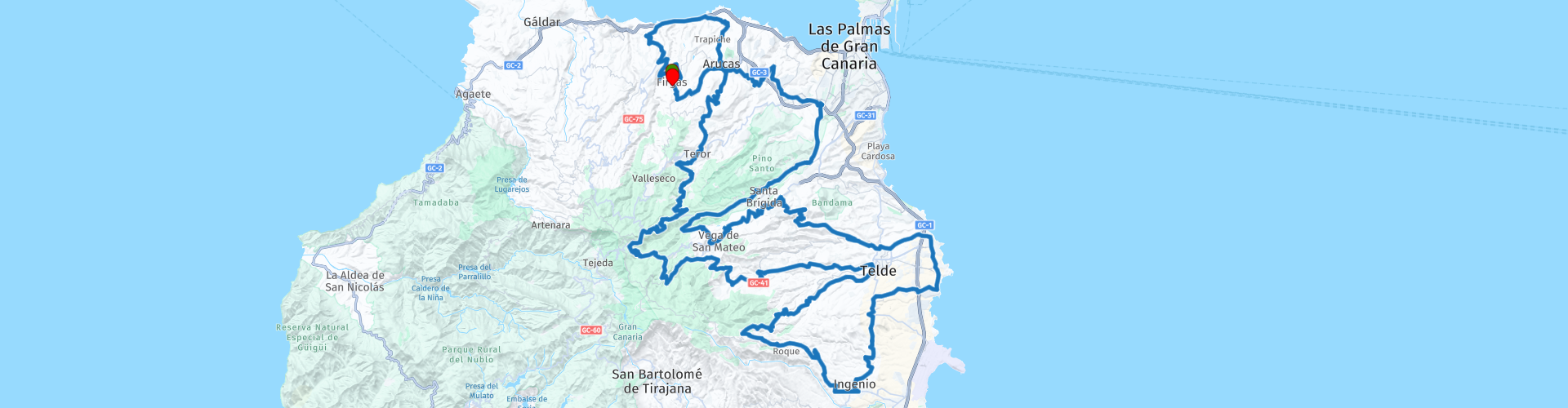
 The start of the route is in the small town of El Risco. The route is mainly about the smaller, beautiful roads, which are equipped with good asphalt. You really have to do your best to find a straight, it is all bends that you will encounter in the route. Assume that the straps will be fully used! After more than 190 kilometers you will return to El Risco.
The route is for the more advanced motorcyclist. Be aware of tight hairpin bends!
Sights along the way include Balneario de Azuaje, Basilica de Nuestra Senora del Pino, Cuatro Puertas and a few spots with great views.
Because of the beautiful roads, the fantastic landscape and the nice sights, I rate this route with 5 stars.
 Share this route


Animation

Verdict


Duration
8h 20m

Mode of travel
Car or motorcycle

Distance
191.39 km

Countries

 RouteXpert Review
 Enjoy high quality roads, low traffic, spectacular views and endless curves. The landscape is so varied that you will never get bored. It is an absolute paradise for motorcyclists!
The route starts in El Risco and, like part 1, takes you north. After driving for 5 kilometers you will pass Balneario de Azuaje, an abandoned spa town. There are few places in Gran Canaria that are really undiscovered, but Balneario de Azuaje is one of those places that you won't find in the travel guides. In fact, it's so hidden that many locals don't even know it! The 150-year-old Azuaje Spa makes every urban explorer's heart beat faster. In short, do you love abandoned buildings, history and natural beauty? Then turn left, park your vehicle and get into the Urban Exploration!
Balneario de Azuaje or Spa Azuaje was once a prestigious spa town in a green barranco in the north of Gran Canaria. The spa was built about 150 years ago, in the year 1868. At that time, Balneario de Azuaje was a hotel with spa facilities and was popular with wealthy tourists and locals alike.
The route continues on the GC-350 and GC-75 to the coast. Here you head east to descend a little later to the more southerly town of Arucas. Via the GC-43 and GC-230 you reach the town of Teror, where you can visit the Basilica de Nuestra Senora del Pino. This basilica is probably the most important religious building in Gran Canaria and its patron saint is Our Lady of the Pine, many pilgrims come to this church to honor her. The church does not look impressive from the outside, but it is very special in construction with its small dome and certainly nice to see. The church was built in the 17th century and the tower is from 1767. The interior is beautiful, with the main altar with statue of the Virgin as the highlight. The treasury can also be visited, note the beautiful stained glass windows.
In a side room of the church are religious treasures and the statue of the Madonna in a jeweled robe, which can be viewed for a small fee. The statue is a precious work of art from the fifteenth century, which is therefore a few hundred years older than the church itself. On holidays, the statue is displayed outside the church.
After Teror, turn onto GC-42. A beautiful stretch of winding asphalt through an equally beautiful area. Around every corner you get another fantastic view, a real pleasure to drive here! After about 10 kilometers you turn right onto the GC-400, which continues to merrily offering curves and beautiful views.
There is a single spot signposted to stop and enjoy the view, but actually it's worth stopping for a moment at every turn to take in the scenery, amazing!
A little further on, where the GC-400 has been abandoned for a while and you have arrived at the GC-15 via the GC-220, you will find Bar Perera, where the enjoyment continues for a while. In addition to your delicious cup of coffee, the view over the beautiful mountains around you makes the break even more enjoyable.
You drive to the east of Gran Canaria over a really beautiful piece of asphalt with ditto curves. You come through a small built-up area of the town of Telde, but once you've left it behind, it's fun again with a big G. Don't forget to stop every now and then to take a look at the amazingly beautiful surroundings. A single place where you can do that is indicated, but there are many!
Along the old road between Ingenio and Telde, on the Montaña Bermaje, is one of the largest archaeological sites in the Canary Islands, Cuatro Puertas. The complex consists of several caves and takes its name from one of them, which has four entrances, or four doors (cuatro puertas). These openings were carved out of the rock by the original inhabitants of Gran Canaria, the Guanches. The mountain was probably a sacred place in the time of the Guanches. Evidence for this is the presence of an altar above the Cuatro Puertas cave. Religious rituals were probably performed at this altar. On the south side of the Montaña Bermaje you will find a cave complex that is still in very good condition. The caves have doors and windows and some sleeping alcoves. On the walls of the caves you can see triangular signs, which may have to do with fertility rituals of the Guanches. Interesting water supply systems can be seen outside. From the caves on the south side of the mountain you have a beautiful view of the sea and the valley below.
A few kilometers away, in Playa de Malenara, you have the opportunity to enjoy lunch. Turn right at the indicated spot, park your vehicle and walk onto the boulevard. You can choose from a few restaurants. While eating you have a beautiful view over the sea.
After lunch you basically just keep turning corners: bend after bend after bend, there seems to be no end to it. Via a planned coffee break at Restaurant Guiniguada on the GC-42 you will pass the botanical garden Viera y Clavijo, located in the Guiniguada ravine. In this ravine you will find a truly beautiful place: the Jardín Botánico Viera y Clavijo, the largest in Spain and one of the best in the world. A walk through the 27 hectares will allow you to discover the varied flora that the Canary Islands can boast of. Located in the capital of Gran Canaria, in the northeast of the island, it is home to exotic and incredible plant species and over 500 endemic plants, some in danger of extinction.
The creation and layout of the garden was the life's work of the Swedish botanist Erik Ragnar Svensson (1910–1973). He searched for a long time for a place where as many endemic species of the island as possible could thrive. He eventually found a suitable site, with natural waterfalls and caves, on a steep slope in the Barranco de Guiniguada. Construction began in 1952 and it opened in 1959. Svenson was the director until his death and was then succeeded by Englishman David Bramwell.
After this natural beauty you meander for about 20 kilometers on beautiful back roads that again demand a lot from your steering skills. Eventually you will return to El Risco, the place where your route started.
Have fun driving this route!


 Links
Links  Usage
Usage Want to download this route?
You can download the route for free without MyRoute-app account. To do so, open the route and click 'save as'. Want to edit this route?
No problem, start by opening the route. Follow the tutorial and create your personal MyRoute-app account. After registration, your trial starts automatically.  Disclaimer
Use of this GPS route is at your own expense and risk. The route has been carefully composed and checked by a MyRoute-app accredited RouteXpert for use on TomTom, Garmin and MyRoute-app Navigation.
Changes may nevertheless have occurred due to changed circumstances, road diversions or seasonal closures. We therefore recommend checking each route before use.
Preferably use the route track in your navigation system. More information about the use of MyRoute-app can be found on the website under 'Community' or 'Academy'.

Canary Islands
About this region
The Canary Islands (; Spanish: Canarias, pronounced [kaˈnaɾjas]), also known informally as the Canaries, is a Spanish archipelago in the Atlantic Ocean, in a region known as Macaronesia. At their closest point to the African mainland, they are 100 kilometres (62 miles) west of Morocco. They are the southernmost of the autonomous communities of Spain, and are located in the African Tectonic Plate. The archipelago is economically and politically European, and is part of the European Union.The eight main islands are (from largest to smallest in area) Tenerife, Fuerteventura, Gran Canaria, Lanzarote, La Palma, La Gomera, El Hierro and La Graciosa. The archipelago includes many smaller islands and islets, including Alegranza, Isla de Lobos, Montaña Clara, Roque del Oeste, and Roque del Este. It also includes a number of rocks, including those of Salmor, Fasnia, Bonanza, Garachico, and Anaga. In ancient times, the island chain was often referred to as "the Fortunate Isles". The Canary Islands are the southernmost region of Spain, and the largest and most populous archipelago of Macaronesia. Because of their location, the Canary Islands have historically been considered a bridge between the four continents of Africa, North America, South America, and Europe.In 2019, the Canary Islands had a population of 2,153,389, with a density of 287.39 inhabitants per km2, making it the eighth most populous autonomous community of Spain. The population is mostly concentrated in the two capital islands: around 43% on the island of Tenerife and 40% on the island of Gran Canaria.
The Canary Islands, especially Tenerife, Gran Canaria, Fuerteventura, and Lanzarote, are a major tourist destination, with over 12 million visitors per year. This is due to their beaches, tropical to subtropical climate, and important natural attractions, especially Maspalomas in Gran Canaria, Teide National Park, and Mount Teide (a World Heritage Site) in Tenerife. Mount Teide is the highest peak in Spain and the third tallest volcano in the world, measured from its base on the ocean floor. The islands have warm summers and winters warm enough for the climate to be technically tropical at sea level. The amount of precipitation and the level of maritime moderation vary depending on location and elevation. The archipelago includes green areas as well as desert areas. The islands’ high mountains are ideal for astronomical observation, because they lie above the temperature inversion layer. As a result, the archipelago boasts two professional observatories: Teide Observatory on the island of Tenerife, and Roque de los Muchachos Observatory on the island of La Palma.In 1927, the Province of Canary Islands was split into two provinces. In 1982, the autonomous community of the Canary Islands was established. The cities of Santa Cruz de Tenerife and Las Palmas de Gran Canaria are, jointly, the capital of the islands. Those cities are also, respectively, the capitals of the provinces of Santa Cruz de Tenerife and Las Palmas. Las Palmas de Gran Canaria has been the largest city in the Canaries since 1768, except for a brief period in the 1910s. Between the 1833 territorial division of Spain and 1927, Santa Cruz de Tenerife was the sole capital of the Canary Islands. In 1927, it was ordered by decree that the capital of the Canary Islands would be shared between two cities, and this arrangement persists to the present day. The third largest city in the Canary Islands is San Cristóbal de La Laguna (a World Heritage Site) on Tenerife. This city is also home to the Consejo Consultivo de Canarias, which is the supreme consultative body of the Canary Islands.During the Age of Sail, the Canaries were the main stopover for Spanish galleons on their way to the Americas, which sailed that far south in order to catch the prevailing northeasterly trade winds.
Read more on Wikipedia
The Canary Islands, especially Tenerife, Gran Canaria, Fuerteventura, and Lanzarote, are a major tourist destination, with over 12 million visitors per year. This is due to their beaches, tropical to subtropical climate, and important natural attractions, especially Maspalomas in Gran Canaria, Teide National Park, and Mount Teide (a World Heritage Site) in Tenerife. Mount Teide is the highest peak in Spain and the third tallest volcano in the world, measured from its base on the ocean floor. The islands have warm summers and winters warm enough for the climate to be technically tropical at sea level. The amount of precipitation and the level of maritime moderation vary depending on location and elevation. The archipelago includes green areas as well as desert areas. The islands’ high mountains are ideal for astronomical observation, because they lie above the temperature inversion layer. As a result, the archipelago boasts two professional observatories: Teide Observatory on the island of Tenerife, and Roque de los Muchachos Observatory on the island of La Palma.In 1927, the Province of Canary Islands was split into two provinces. In 1982, the autonomous community of the Canary Islands was established. The cities of Santa Cruz de Tenerife and Las Palmas de Gran Canaria are, jointly, the capital of the islands. Those cities are also, respectively, the capitals of the provinces of Santa Cruz de Tenerife and Las Palmas. Las Palmas de Gran Canaria has been the largest city in the Canaries since 1768, except for a brief period in the 1910s. Between the 1833 territorial division of Spain and 1927, Santa Cruz de Tenerife was the sole capital of the Canary Islands. In 1927, it was ordered by decree that the capital of the Canary Islands would be shared between two cities, and this arrangement persists to the present day. The third largest city in the Canary Islands is San Cristóbal de La Laguna (a World Heritage Site) on Tenerife. This city is also home to the Consejo Consultivo de Canarias, which is the supreme consultative body of the Canary Islands.During the Age of Sail, the Canaries were the main stopover for Spanish galleons on their way to the Americas, which sailed that far south in order to catch the prevailing northeasterly trade winds.
View region
 Statistics
  8
8Amount of RX reviews (Canary Islands)
 12849
12849Amount of visitors (Canary Islands)
 309
309Amount of downloads (Canary Islands)
 Route Collections in this region
 Exploring the magnificent roads of Gran Canaria in three days
Nog een weekje vakantie tegoed? En het snertweer zat? Op vier uur vliegen is het, in tegenstelling tot het wisselvallige Nederlandse weer, altijd zomer. En Gran Canaria kan dan wel bekend staan om de massa's zonaanbidders, het blijkt ook een waar walhalla voor de motorrijder!
Deze drie routes zijn prima in één weekend of midweek te rijden. Ze brengen je naar alle hoeken van het eiland waar het maar enigszins interessant is om te rijden. En laten we eerlijk zijn, dat is bijna het hele eiland! Laat je overweldigen door de fantastische krullende wegen, voorzien van strak asfalt, die over het eiland zijn aangelegd, laat je verrassen door de verborgen schatten die aan het massatoerisme voorbij gaan.
Op het eiland zijn meerdere verhuurders van motoren aanwezig waaronder Motor Rental Bike en Pic Y Poc. Voor het meest actuele aanbod en prijzen schiet je een zoekopdracht in bij Google, dan ben je vrijwel zeker dat de data niet verouderd is.
Per route worden in de review enkele bezienswaardigheden besproken. Deze vertellen vaak iets over de geschiedenis van het gebied waarin je rijdt. Leuke weetjes, best leerzaam. Het staat je geheel vrij om deze bezienswaardigheden te bezoeken, je kunt uiteraard ook je eigen interessante punten bepalen.
Maar het belangrijkste waar je waarschijnlijk voor bent afgereisd naar dit gebied, is het geweldige rijden en het schitterende weer. En zoals hierboven al is gezegd, je bevindt je in een waar motorparadijs waarin het fantastisch sturen is!
De routes van deze collectie:
Roundtour Gran Canaria day 1 West - 223km
Roundtour Gran Canaria day 2 North-East - 191km
Roundtour Gran Canaria day 3 South - 245km
Heel veel plezier bij het rijden van deze routes!
View Route Collection